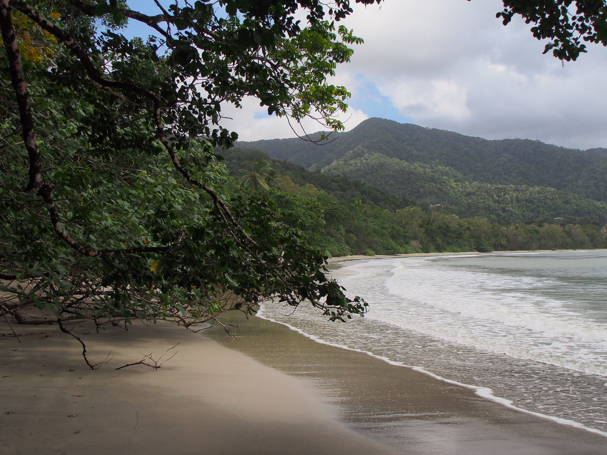
A curving sandy beach under overhanging rainforest branches, with forested green hills rising behind the shore

Queensland, Australia

Cape Tribulation

The beach at Cape Tribulation, where the Daintree rainforest reaches the sea. (rheins / Wikimedia Commons · CC BY 3.0)

A rainforest headland and scattered settlement on the coast of Far North Queensland, north of the Daintree River, where the lowland rainforest of the Wet Tropics runs down to beaches facing the Great Barrier Reef. Named by James Cook in 1770, it is now a small, off-grid community of guesthouses, campgrounds and cafés inside Daintree National Park, on the country of the Eastern Kuku Yalanji people.

Neighbourhoods

  • Cape Tribulation settlement and beaches
    • Beaches
    • Rainforest walks
    • First-time visitors

    The northern end of the sealed road, where a handful of guesthouses, campgrounds, cafés and a small shop sit under the forest canopy. Short tracks lead to the beaches around the headland, including Cape Tribulation Beach, and boardwalks such as Kulki and Dubuji wind through mangroves and fan palms.

    Open in Maps
  • Cow Bay and Diwan
    • Quiet and residential
    • Rainforest stays
    • Tropical fruit

    A stretch of the Daintree coast between the ferry and the cape, with rainforest lodges, holiday houses, fruit orchards and beaches. It is one of the more settled parts of the coast north of the river, and the Daintree Discovery Centre, with a 23-metre canopy tower, lies on the road at Cow Bay.

    Open in Maps
  • Daintree Village
    • River cruises
    • Birdwatching
    • Historic township

    A small township upstream of the ferry on the southern side of the Daintree River, reached without crossing it. It began as a settlement of timber workers cutting red cedar in the late 1870s and 1880s and is now the base for crocodile and birdwatching cruises on the river and its creeks.

    Open in Maps

Things to do

Rainforest and national park

  • Daintree National Parkpark

    The national park that covers the coastal rainforest from the Daintree River to the Bloomfield River, as well as Mossman Gorge, part of the Wet Tropics of Queensland World Heritage Area and now jointly managed with the Eastern Kuku Yalanji people.

    Open in Maps
  • Daintree Rainforestpark

    Part of some of the oldest surviving rainforest communities in the world, rich in primitive flowering plant families, and home to rare species such as the southern cassowary and Bennett's tree-kangaroo.

    Open in Maps
  • Thornton Peakviewpoint

    Queensland's fourth-highest peak, 1,374 metres high and covered in rainforest, rising above the Daintree; the Eastern Kuku Yalanji call it Wundu, and it has spiritual significance for them.

    Open in Maps

River and coast

  • Daintree Riverattraction

    The broad tidal river crossed by cable ferry on the way north, where boat cruises look for saltwater crocodiles, kingfishers and other birds among the mangroves.

    Open in Maps
  • Bloomfield Tracktrail

    The partly sealed four-wheel-drive road that continues north from Cape Tribulation through steep rainforest and creek crossings to Wujal Wujal, completed in 1984 amid protests and blockades.

    Open in Maps

Short trips from Cape Tribulation

  • Mossman Gorgepark

    A river gorge in the southern section of Daintree National Park, near Mossman, on Kuku Yalanji land; the Mossman Gorge Centre, with an Indigenous art gallery, runs a shuttle bus to a loop walk through the rainforest.

    Open in Maps
  • Wujal Wujalneighborhood

    A Kuku Yalanji community on the Bloomfield River at the northern end of the Bloomfield Track, near the Bloomfield Falls, formerly the Bloomfield River Mission.

    Open in Maps
  • Port Douglasneighborhood

    The resort town south of the Daintree with Four Mile Beach and a marina, from which companies run daily trips to the outer Great Barrier Reef and the Low Isles.

    Open in Maps

Eat and drink

Long-standing places and food districts in Cape Tribulation. Hours, ratings and directions come from your maps app, always current.

Daintree coast food

  • Cafés and restaurants at Cape Tribulationneighborhood

    A few cafés, bars and resort restaurants clustered around the end of the sealed road, serving casual meals, seafood, burgers and tropical fruit smoothies to campers and day visitors.

    Open in Maps
  • Cafés around Cow Bay and Diwanneighborhood

    Roadside cafés and farm stalls on the forest road, several of them selling ice cream and sorbet made from fruit grown on the surrounding orchards.

    Open in Maps
  • Daintree Village cafésneighborhood

    A small cluster of cafés and restaurants in the riverside township, serving classic Australian dishes alongside tropical fruit grown in the Daintree, and one specialising in native Australian food.

    Open in Maps

Experience Cape Tribulation

History

The coast between the Daintree and Bloomfield rivers is the country of the Eastern Kuku Yalanji people, who lived from the rainforest, the reef and the creeks for many thousands of years. Their knowledge of plants, seasons and sacred places is tied to features of the land, and the mountains, rivers and reefs of the area appear in their stories.

The headland's English name comes from James Cook. In June 1770 the Endeavour sailed past the point he called Cape Tribulation and soon afterwards struck a reef offshore, now known as Endeavour Reef; Cook wrote that here began all their troubles. The damaged ship was eventually beached for repairs at the Endeavour River, where Cooktown now stands. Europeans settled the Daintree area from the late nineteenth century, cutting red cedar and other timber and clearing land for farms, but the steep coast north of the river remained remote and lightly settled.

In the 1970s a major push cleared more of the coastal flatlands, and much of the land was held in private blocks. In 1983 conservationists blockaded the construction of a road north from Cape Tribulation to Bloomfield, drawing national and international attention; the road was built, but the campaign helped lead to the listing of the Wet Tropics of Queensland as a World Heritage Site in 1988. Government and charitable buyback schemes have since returned many private blocks to the forest, and in 2021 Daintree National Park was handed back to the Eastern Kuku Yalanji, who now manage it jointly with the state.

Culture & Customs

Cape Tribulation's identity is bound up with the forest. Residents include conservationists, tourism operators, farmers and people who came for a quieter life off the grid, and debates over development, the road, the ferry and power supply have shaped local politics for decades. There is no mains electricity north of the Daintree River, so homes and businesses rely on solar panels and generators, a fact that many residents regard as part of what keeps the area wild.

Kuku Yalanji culture is increasingly visible to visitors. Aboriginal cultural experiences are offered in the area, and the Mossman Gorge Centre has an Indigenous art gallery. Thornton Peak, known to the Eastern Kuku Yalanji as Wundu, has spiritual significance for them.

Much of the area's culture is outdoor and informal: guided night walks to look for frogs, possums and insects, birdwatching for kingfishers and the southern cassowary, and evenings in a beach bar or around a campground. Scientists and students also come here, as the lowland forest is studied for its ancient plant families, which help explain how flowering plants evolved. Dress is casual, and most social life happens in the handful of cafés and lodges along the road.

Daily Life

The permanent population of the Daintree coast is small, counted in the hundreds rather than thousands, and spread along the road in houses and farms hidden in the forest. Tourism is the main employer, from lodges, campgrounds and cafés to guiding, reef boats and the river ferry; some residents grow tropical fruit, and others work in conservation, research or the arts.

Life follows the seasons. In the dry season, from about May to October, the road is busy with hire cars, campervans and tour buses, and businesses work long days. In the wet season visitor numbers fall, rain can cut creek crossings, and some residents travel south or turn to maintenance and repair. Shopping, banking, schooling beyond the primary level and most health services mean a drive across the ferry to Mossman or further, to Port Douglas or Cairns.

Current issues include the balance between tourism and protection of the forest, the future of the ferry crossing, where a bridge has been discussed but rejected by the Queensland Government, the cost of living off the grid, road safety for cassowaries, and flooding: in 2023 torrential rain from ex-Cyclone Jasper brought a record flood of 15 metres at Daintree.

Food

Eating at Cape Tribulation is simple and outdoor: café breakfasts, burgers, fish and chips, pizzas and plates of local seafood, often taken on a veranda facing the forest. Barramundi, a large white-fleshed fish of tropical rivers and estuaries, appears on many menus, along with prawns and reef fish such as coral trout when available from boats in Port Douglas and Cairns.

The orchards around Cow Bay and Diwan grow rare tropical fruits, and some farms offer tastings or tours. Fruits of this kind include rambutan, a hairy-skinned relative of the lychee; mangosteen, with sweet white segments under a purple rind; and black sapote, sometimes called chocolate pudding fruit for the taste and texture of its ripe flesh. Some of the fruit is turned into ice cream and sorbet sold at farm stalls along the road, and smoothies made from the season's fruit are common.

Native foods also feature: a restaurant at Daintree Village serves native Australian cuisine, and the Davidson's plum is the fruit of a rainforest tree of northern Queensland. Daintree Tea, grown in the area, is sold in shops and restaurants as the local specialty. Most visitors self-cater for part of their stay, so groceries are best bought before crossing the river.

Planning tools

Budget

Accommodation north of the river is limited and spread out, from campgrounds and backpacker lodges to rainforest retreats, and it fills in the dry season. Food and fuel cost more than in Cairns because everything is trucked in across the ferry, and guided walks, river cruises and reef trips are the main extra costs. A hire car, a bus or a place on a day tour is needed to get there.

Daily Budget Midrange
USD 170–300 (rainforest cabin or lodge, café and restaurant meals, a guided walk or river cruise, a hire car)
Daily Budget Shoestring
USD 70–110 (campsite or hostel bed, self-catering with supplies from Mossman, free beaches and boardwalks)

Stock up on groceries and fuel in Mossman or Port Douglas before crossing the river; the beaches and the national park boardwalks cost nothing.

Best Time to Visit

May to October, the dry season, when days are warm, humidity is lower and the roads and walks are at their best. The wet season, roughly November to March, brings heavy rain, swollen creeks, high humidity and a chance of cyclones, and the Bloomfield Track and some creek crossings can close; the forest is at its greenest then and visitors are fewest.

Suggested Number of Days

Many people see the coast on a day tour, but a night or two north of the river allows the forest at dawn and dusk, when wildlife is most active. A longer stay suits those adding a reef trip, a river cruise or a four-wheel-drive journey further north.

First Visit
1–2 days
With Surroundings
3–4 days

Transportation

Public transport is very limited. Most visitors drive a hire car or come on an organised tour or bus from Cairns or Port Douglas. The cable ferry carries cars across the river, and a sealed but narrow, winding road runs from the ferry to Cape Tribulation through forest with steep hills and many creeks. Beyond the end of the bitumen, the Bloomfield Track needs a high-clearance four-wheel drive and is affected by rain.

Drive slowly and watch for cassowaries crossing the road, and check whether hire car terms allow the Bloomfield Track before heading north.

Airport & Station Connections

Cairns, about 110 kilometres to the south, has the nearest airport, about three hours away by road via Port Douglas and Mossman, including the ferry crossing of the Daintree River. Most visitors arrive by hire car or on a coach or minibus tour from Cairns or Port Douglas.

Walkability

The settlement itself is spread along the road in the forest, and the beaches and boardwalks around the cape are reachable on foot. Places further down the coast, such as Cow Bay or the ferry, are too far to walk and the road has no footpath. There is little or no street lighting, so a torch is useful at night.

Safety

Crime is low; the risks here come from nature. Saltwater crocodiles live in the rivers, creeks and estuaries and can turn up on the beaches. Box jellyfish and Irukandji stingers are present in coastal waters in the warmer months, roughly October to May. Cassowaries can be dangerous if approached or fed.

Obey crocodile warning signs, stay away from the water's edge at creek mouths, keep well back from cassowaries and never feed them, and wear a stinger suit if swimming in the warmer months. Check current official travel advice before travelling.

Climate

A wet tropical climate, with an average annual rainfall of about 3,900 millimetres and warm to hot weather all year. Most rain falls in the wet season; the dry season is sunnier and less humid, though showers still occur.

Summer
hot, humid and very wet — December to February, around 25–33°C as on much of the Queensland coast, with heavy downpours and a risk of cyclones
Winter
warm and drier — June to August, about 18–26°C, similar to Cairns

Local Customs

This is the country of the Eastern Kuku Yalanji people, who are the traditional owners of Daintree National Park and manage it jointly with the Queensland Government. Some places, such as Thornton Peak (Wundu), have spiritual significance, and signs at cultural sites should be respected. The atmosphere is relaxed and casual, and many residents care strongly about the forest.

Tipping is not expected, though rounding up for good service is welcome. Stay on marked tracks, take rubbish out of the park, respect signs at sacred sites and ask before photographing people.

Common Payment Methods

The currency is the Australian dollar. Cards and contactless payment are widely accepted at shops, cafés and lodges, but services north of the river are few, so carrying some cash is sensible. Mossman and Port Douglas have banks and supermarkets.