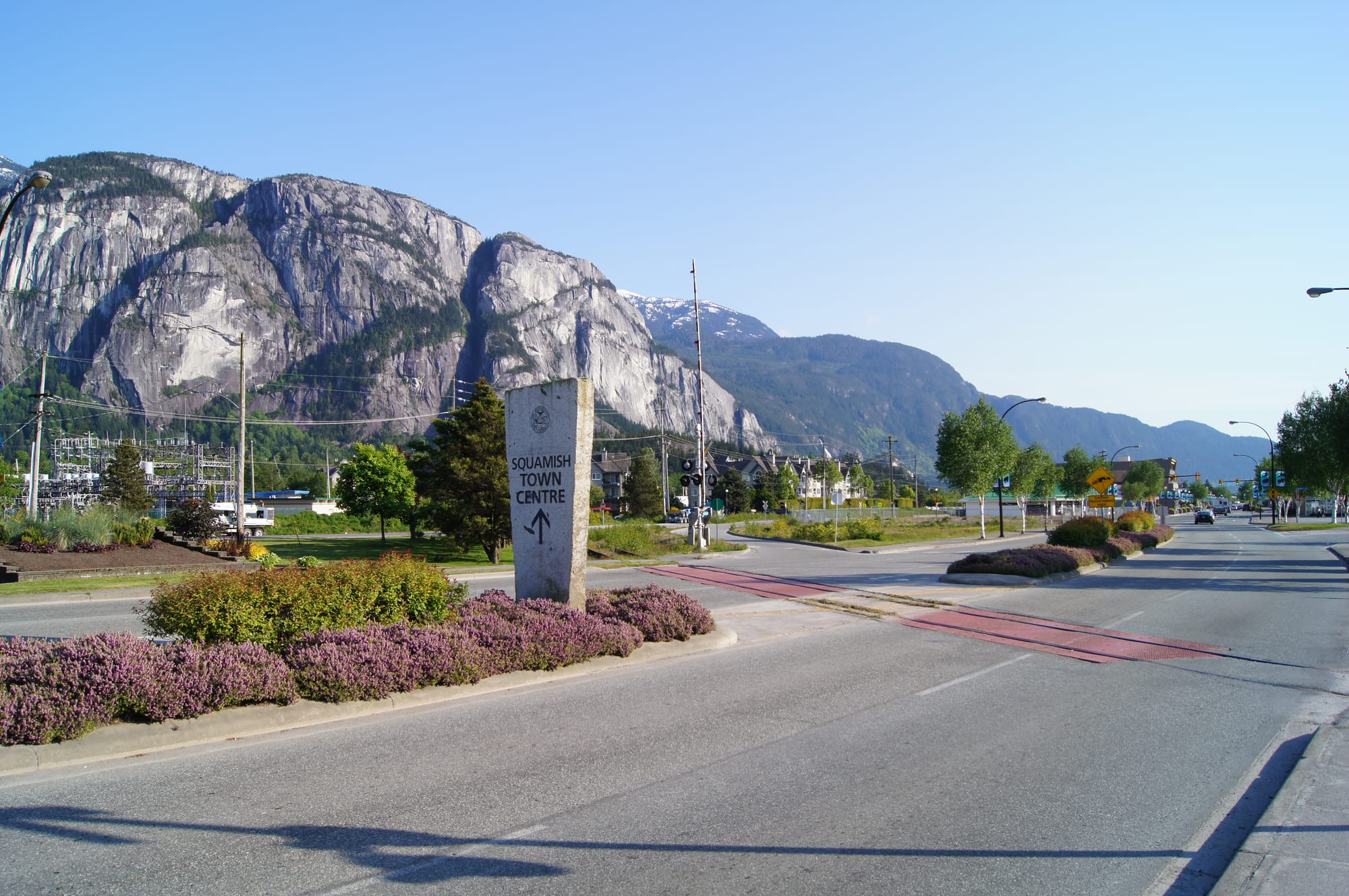
A wide road into downtown Squamish with a stone town-centre sign and the grey granite cliffs of the Stawamus Chief rising behind

British Columbia, Canada

Squamish

Cleveland Avenue at the entrance to downtown Squamish, with the granite face of the Stawamus Chief behind. (Straitgate / Wikimedia Commons · CC BY-SA 3.0)

A town of about 24,000 people at the head of Howe Sound, an hour north of Vancouver on the Sea to Sky Highway and halfway to Whistler. A logging and port town for most of its life, it has become one of Canada's outdoor capitals, known for rock climbing on the granite wall of the Stawamus Chief, windsurfing on the estuary, mountain biking and the winter gathering of bald eagles at Brackendale.

Neighbourhoods

  • Downtown
    • First-time visitors
    • Best for food
    • Close to the waterfront

    The original townsite on the flat land between the Squamish River estuary and the Mamquam Blind Channel, centred on Cleveland Avenue. Low commercial blocks hold the cafés, a brewpub, outdoor shops and restaurants, and the waterfront at the southern end is former industrial and port land.

    Open in Maps
  • Brackendale
    • Quiet and residential
    • Wildlife

    A spread-out community about 7 km north of downtown along the Squamish River, now a suburban neighbourhood with its own small cluster of shops and the Brackendale Art Gallery. Eagle Run, on the riverbank here, is the place to watch the bald eagles that gather on the river every winter.

    Open in Maps
  • Garibaldi Estates and Garibaldi Highlands
    • Families
    • Close to trails

    The suburban districts on the bench and slopes north of the Mamquam River, home to much of the town's population. They sit near Alice Lake, the Diamond Head entrance to Garibaldi Provincial Park and the highway shops, and feel more like a Vancouver suburb than the old downtown.

    Open in Maps
  • Valleycliffe and the Chief
    • Climbers
    • Close to trails

    The neighbourhood south of downtown on the far side of the Stawamus River, directly beneath the Chief's granite walls and next to the Smoke Bluffs climbing area. It is a quiet grid of family houses where climbers and the campground at the foot of the cliffs set the tone.

    Open in Maps

Things to do

Famous landmarks

  • Stawamus Chieflandmark

    A granite monolith about 700 metres high at the southern edge of town, one of North America's great rock-climbing walls, with steep hiking trails up its back to three summits above Howe Sound.

    Open in Maps
  • Shannon Fallsattraction

    A waterfall dropping about 335 metres in a series of cascades beside the highway just south of the Chief, among the highest in the province and a short walk from the car park.

    Open in Maps
  • Sea to Sky Gondolaattraction

    A gondola opened in 2014 that climbs from the highway near Shannon Falls to a summit lodge with a suspension bridge, viewing platforms and trails looking down Howe Sound.

    Open in Maps

Museums and heritage

  • Railway Museum of British Columbiamuseum

    The outdoor railway museum on a 12-acre site, opened in 1994 as the West Coast Railway Heritage Park, where the Royal Hudson steam locomotive No. 2860 is preserved alongside other historic railway equipment.

    Open in Maps
  • Britannia Mine Museummuseum

    The former copper mine at Britannia Beach, about 10 km south on Howe Sound, with an underground train tour and the restored concentrator mill building, a National Historic Site.

    Open in Maps

Parks, lakes and the estuary

  • Alice Lake Provincial Parkpark

    A forested park about 10 km north of downtown with four small lakes, a popular swimming beach on Alice Lake, a campground and trails for hiking and mountain biking.

    Open in Maps
  • Brackendale Eagles Provincial Parkpark

    A protected stretch of the west bank of the Squamish River, closed to visitors, where large numbers of bald eagles gather to feed on spawning salmon between November and February, watched from Eagle Run on the Brackendale side; a record 3,769 eagles were counted here in 1994.

    Open in Maps
  • Squamish Estuarypark

    The marshes and channels where the Squamish River meets Howe Sound, west of downtown, with flat trails used by walkers and birdwatchers, and the afternoon winds that make the Spit a windsurfing and kiteboarding spot.

    Open in Maps
  • Porteau Cove Provincial Parkpark

    A waterfront park on Howe Sound about 17 km south, known for scuba diving on artificial reefs that include two sunken vessels, with a pier and a campground on the shore.

    Open in Maps

Walks and viewpoints

  • Garibaldi Provincial Parkpark

    The vast alpine park east of town, whose southernmost entrance is at Diamond Head in Squamish, with more than 150 glaciers and the volcanic peak of Mount Garibaldi.

    Open in Maps
  • Murrin Provincial Parkpark

    A small park on Browning Lake beside the highway south of town, with a picnic ground, a trail to a collection of petroglyphs and rock faces popular with local climbers.

    Open in Maps
  • Stawamus Chief Provincial Parktrail

    The park around the monolith, with a walk-in campground and steep trails up its back to the three summits, with chains and ladders bolted to the rock on the steepest sections.

    Open in Maps

Short trips from the town

  • Whistlerattraction

    The resort town about 50 km north along the Sea to Sky Highway, with the Whistler Blackcomb ski area and a pedestrian village.

    Open in Maps
  • Lions Bay and Howe Sound viewpointsviewpoint

    The fjord-like sound stretching south to Horseshoe Bay, seen from pull-outs along the highway and from the ferry crossing to Gibsons on the Sunshine Coast.

    Open in Maps

Seasonal events

  • Winter eagle seasonMid-November to late February

    The winter weeks when bald eagles gather on the Squamish and Cheakamus rivers to feed on salmon, watched from Eagle Run in Brackendale, where volunteers often staff the viewing area at weekends.

  • Squamish Days Loggers SportsA weekend in August

    A weekend festival of logging competitions held in the town every August, one of the best-known loggers' sports events in Canada.

Eat and drink

Long-standing places and food districts in Squamish. Hours, ratings and directions come from your maps app, always current.

Food districts and markets

  • Cleveland Avenue and downtownneighborhood

    The main street and the blocks around it hold most of the town's restaurants and cafés — coffee roasters, bakeries, sushi, pizza, pub food and a few more ambitious kitchens, with a strong outdoor-crowd breakfast trade.

    Open in Maps
  • Squamish breweriesneighborhood

    The town's craft beer runs from the Howe Sound Brewpub on Cleveland Avenue, known for its in-house beers, to other local brewers; beer is the local drink after a day on the rock or the trails.

    Open in Maps
  • Garibaldi Village and the highway shopsneighborhood

    The shopping plazas beside the highway in Garibaldi Estates hold supermarkets, takeaways and casual restaurants used by residents of the northern neighbourhoods.

    Open in Maps

Experience Squamish

History

The Squamish people have lived in the valley and around Howe Sound for thousands of years, with villages at the river mouth and up the valley. The name of the town comes from their language, Sḵwx̱wú7mesh, and the Stawamus Chief takes its name from a village at its foot. Captain George Vancouver sailed into Howe Sound in 1792, but settlement came slowly: a few farms at Brackendale and the mouth of the river in the late 19th century, reached only by boat from Vancouver.

Logging and the railway made the town. Boats and barges linked it with Vancouver; the Pacific Great Eastern Railway, later BC Rail, built its line north from Squamish in the 1910s, and the town was its southern terminus for decades until the link to North Vancouver was completed in 1956. A pulp mill opened at Woodfibre across the sound in 1912, a copper mine at Britannia Beach was for a time the largest in the British Empire, and sawmills, logging and the port kept the town working. The road to Vancouver opened in 1958 and was extended to Whistler in the 1960s.

The resource economy ran down in the early 2000s. The Britannia mine had already closed in 1974, the Interfor sawmill closed a few years before the pulp mill, the Woodfibre mill shut in 2006 and the BC Rail passenger service ended in 2002. In their place came the outdoors: climbers had been working the Chief's granite since the first ascent of the Grand Wall in 1961, windsurfers discovered the estuary winds, and the opening of the Sea to Sky Gondola in 2014 and the rebuilding of the highway for the 2010 Winter Olympics turned a logging town between Vancouver and Whistler into a destination and a fast-growing commuter town.

Culture & Customs

Squamish calls itself the Outdoor Recreation Capital of Canada, and the claim is at least half true. The Chief is one of the world's best-known granite climbing areas, with routes of every grade on its walls and on the Smoke Bluffs, and the climbing community that formed around it in the 1960s and 1970s shaped the town's character. Mountain biking followed, with a dense network of trails above the valley; kiteboarders and windsurfers gather at the Spit when the afternoon wind rises; and the rivers draw paddlers and rafters. The mix gives the town a young, fit and informal population.

The logging past survives in Squamish Days, the loggers' sports festival held every August, and in the railway museum's locomotives. Art in the town leans towards the outdoors too — galleries in Brackendale, murals downtown and a growing number of festivals in summer.

The Squamish Nation is the valley's oldest community, with reserves in and around the town and a cultural presence that has grown more visible in recent years, from Squamish-language place names on the highway signs to displays on Squamish history at the gondola summit. Howe Sound itself was designated a UNESCO Biosphere Reserve in 2021 in recognition of its recovery from industrial pollution, and the return of humpback whales, orcas and sea lions to the sound is a point of local pride. Manners are easy-going; what locals expect is that visitors stay on the trails, pick up after themselves and do not feed or crowd the wildlife.

Daily Life

About 24,000 people live in the district, and its population grew by more than a fifth between 2016 and 2021. Many residents commute to Vancouver or Whistler, and the town has become a place where people priced out of the city buy a first house. The economy that once rested on logging, the mill and the port now runs on construction, tourism, outdoor businesses, a university campus and a growing number of people who work remotely; the port still handles some cargo, and a liquefied natural gas plant is being built at the old Woodfibre site across the sound.

Housing costs are a common worry, as across the corridor, with newcomers arriving to escape the higher cost of living in Vancouver and Whistler. Traffic on the Sea to Sky Highway is the other constant topic, especially on winter Sundays when the Whistler skiers drive home.

The rhythm is set by the weather and the light. Summer evenings are long and spent on the trails, the lakes or the patios; winter is dark and wet, and people head to Whistler for snow or to the eagle dykes with a thermos. Youth sports, the climbing and biking communities and the summer festivals are the social fixtures, and most people know the Chief's trails and the Alice Lake loop by heart.

Food

Squamish eats the way an outdoor town does: large breakfasts, strong coffee and beer. The cafés and bakeries along Cleveland Avenue open early for climbers and bikers heading out, and the town's breweries fill in the late afternoon when they come back. Craft beer is the local product above all — the Howe Sound Brewpub on Cleveland Avenue is known for its in-house beers, and other local brewers have followed.

The restaurant scene has grown with the population and now runs from pub food, pizza and burgers to sushi, Thai, Indian and Mexican kitchens, with a handful of more ambitious places using coastal ingredients. Salmon, spot prawns and other seafood from the sound and the coast appear on many menus, as does Fraser Valley produce. Poutine and the Nanaimo bar, both Canadian standards, are everywhere.

Berries matter in summer, when wild berries grow along trails and roadsides, and the salmon runs on the Squamish and Cheakamus rivers, which feed the wintering eagles, are as much a part of the food calendar for the birds as for the people.

Planning tools

Budget

Squamish costs less than Whistler and about the same as Vancouver for food, but lodging is limited and rises sharply in summer. Camping and hostel beds keep costs low for the climbing and biking crowd; a car, gondola tickets and a Whistler day push them up. Most of the headline sights — the Chief, Shannon Falls, the estuary, the eagles — are free apart from parking.

Daily Budget Midrange
USD 200–360 (hotel or rental, restaurant meals, car hire, the gondola or a guided trip)
Daily Budget Shoestring
USD 70–130 (campsite or hostel bed, groceries and takeaway, trails and provincial parks on foot)

Book summer rooms and campsites well ahead, use Squamish as a cheaper base for Whistler, and expect paid parking at the popular trailheads in season.

Best Time to Visit

June to September for dry rock, warm days and the estuary winds that bring windsurfers and kiteboarders. May and October are quieter and often still fine. Winter is wet at sea level but brings the bald eagles to Brackendale from November to February, and the town stays open as a base for Whistler skiing. Snow lies on the high trails well into June.

Suggested Number of Days

A day or two covers the town and its nearest sights. Climbers, mountain bikers and hikers stay longer, and the number grows with the amount of time spent in the surrounding mountains and on the water, or with a side trip north along the highway.

First Visit
1–2 days
With Surroundings
3–4 days

Transportation

The town stretches a long way along the highway and most people get around by car. A local bus system links downtown, Garibaldi Estates, Brackendale and Valleycliffe, and regional buses run along the Sea to Sky corridor to Whistler and Vancouver. Cycling is common on the valley's paved paths and gravel trails, and the downtown core is small enough to walk.

Trailhead car parks for the Chief, Shannon Falls and the gondola fill early on summer weekends; arrive before mid-morning or come midweek.

Airport & Station Connections

Squamish lies about 60 km north of Vancouver on Highway 99, the Sea to Sky Highway, less than an hour's drive from the city; the coach from Vancouver International Airport takes about two hours. Whistler is about 50 km further north. There is no passenger train; coach services from Vancouver and the airport run along the corridor, and many visitors come by hire car from the city.

Walkability

Downtown and the waterfront are flat and walkable, with the estuary trails a few minutes from Cleveland Avenue. The outer neighbourhoods and the sights along the highway are too spread out for walking, and the highway itself has no pavement. Trails to the Chief's peaks are steep and rough and need proper footwear.

Safety

The town is safe and crime is low. The risks are outdoors: falls on the Chief's trails, which have chains and ladders; cold water and strong currents in the rivers; sudden weather on the alpine trails; and bears, which are common in the valley from spring to autumn.

Carry bear spray on backcountry trails, check wildfire and avalanche bulletins, and leave nothing visible in a parked car. Keep food locked away at campsites and tell someone the route before heading into Garibaldi. Check current official travel advice before travelling.

Climate

A mild, very wet coastal climate at sea level, with the mountains behind holding snow for much of the year. Rain falls heavily from October to March; summers are warm and much drier, with reliable afternoon winds off the sound. Over 2,200 mm of rain falls in a year, making it one of the wettest inhabited places in Canada.

Summer
warm and fairly dry — an oceanic climate in which even the warmest month averages below 22°C, cooler by the water, with strong afternoon winds on the estuary
Winter
moderately cold and wet — monthly averages stay above 0°C, long stretches of rain, occasional snow in town and deep snow on the mountains

Local Customs

An informal outdoor town where fleece and climbing shoes are everyday dress and conversation turns quickly to conditions on the rock, the river or the trails. Tipping of 15–20 per cent is expected in restaurants and bars. The town lies in the traditional territory of the Squamish Nation, whose name it carries; the Nation's reserves along the Squamish River are part of the valley, and visitors should treat cultural sites with respect.

The legal drinking age in British Columbia is 19, and drinking in public places is restricted. Keep well back from eagles and other wildlife, and ask before photographing people.

Common Payment Methods

The currency is the Canadian dollar. Cards and contactless payment are accepted almost everywhere, and bank ATMs are downtown and at the highway plazas. A little cash is useful for small vendors, campground fees and parking machines that do not take cards.