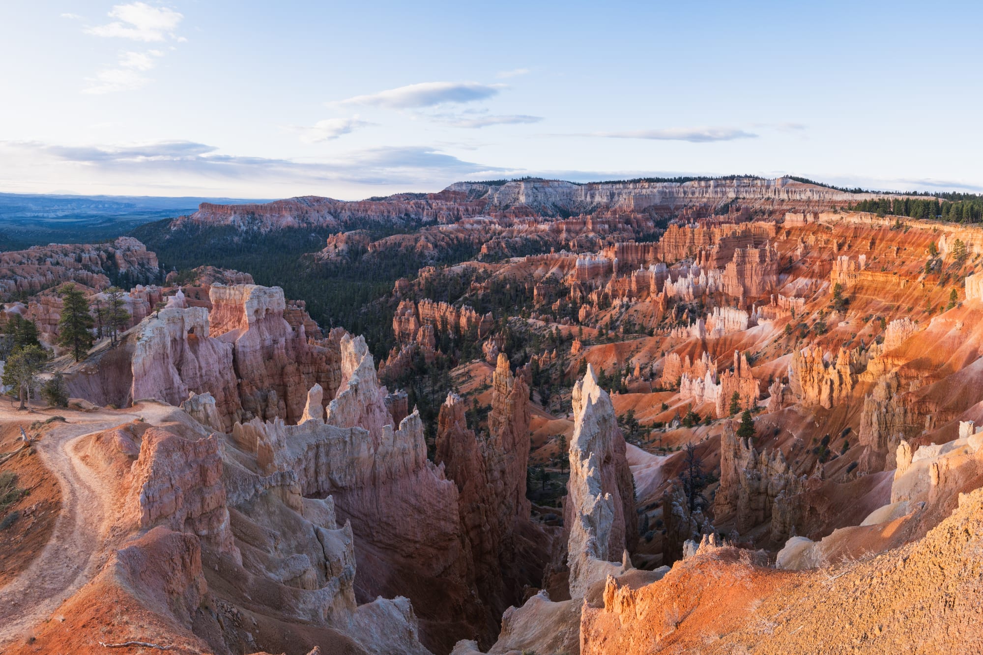
Orange, pink and white hoodoos filling the Bryce Amphitheater in soft morning light, with a trail along the rim on the left

The Rocky Mountains, United States

Bryce Canyon City

The Bryce Amphitheater seen from Sunrise Point, a short drive from Bryce Canyon City. (Christian David / Wikimedia Commons · CC BY-SA 4.0)

A small town on the high plateau of southern Utah, just outside the entrance to Bryce Canyon National Park. It grew from a lodge built in 1916 to serve the first visitors to the canyon and was incorporated only in 2007. Today it is a strip of lodging, shops and services at the edge of the forest, a few minutes from amphitheatres of orange hoodoos.

Neighbourhoods

  • The town strip
    • First-time visitors
    • Close to the park
    • Shuttle access

    A short stretch of State Route 63 just north of the park boundary, lined with lodging, campgrounds, a general store, restaurants, petrol stations and outfitters for horse rides and tours. In summer a park shuttle runs from parking outside the park to the viewpoints, so a car can be left behind.

    Open in Maps
  • Inside the park
    • Views
    • Hiking
    • Quiet nights

    The park's own lodge, cabins and campgrounds sit among ponderosa pines close to the rim of the Bryce Amphitheater, a short walk from the viewpoints. Nights are dark and quiet, and there is little else around.

    Open in Maps
  • Tropic
    • Local life
    • Quieter base

    A small town founded in 1891 in the Tropic Valley below the eastern edge of the plateau, about 15 minutes' drive away. It has a handful of places to eat and stay, and views up to the cliffs of the park.

    Open in Maps

Things to do

Bryce Canyon

  • Bryce Canyon National Parkpark

    Natural amphitheatres carved into the plateau edge, filled with orange, pink and white rock spires called hoodoos. The Bryce Amphitheater, seen from Sunrise, Sunset, Inspiration and Bryce points, is the best known; the park's 1920s lodge stands near its rim.

    Open in Maps
  • Paunsaugunt Plateauviewpoint

    The high, forested plateau on which the town stands; its eroded eastern edge forms the amphitheatres of the park, and the park road follows it south to the highest viewpoints.

    Open in Maps

Short trips from the town

  • Utah State Route 12viewpoint

    A scenic highway that runs east through Tropic and Escalante towards Capitol Reef, crossing high ridges and canyon country.

    Open in Maps
  • Kodachrome Basin State Parkpark

    A state park about 20 miles south-east of Bryce Canyon National Park, known for its sandstone spires and columns called sand pipes, rarely found elsewhere.

    Open in Maps
  • Grand Staircase–Escalante National Monumentpark

    A vast protected area of plateaus, cliffs and slot canyons that begins east of Bryce Canyon.

    Open in Maps
  • Panguitchattraction

    The county seat, about 20 miles west, settled by Latter-day Saint pioneers in 1864 and known for its rose-coloured brick houses.

    Open in Maps
  • Cedar Breaks National Monumentpark

    A natural amphitheatre with hoodoos in the same rock formation as Bryce Canyon, about 25 miles west on the Markagunt Plateau near Cedar City, its rim over 10,000 feet high.

    Open in Maps

Seasonal events

  • Bryce Canyon Astronomy FestivalJune

    A festival of night-sky viewing, talks and telescope sessions in the park, which is recognised as a Dark Sky Park.

Eat and drink

Long-standing places and food districts in Bryce Canyon City. Hours, ratings and directions come from your maps app, always current.

Food in and around town

  • The town stripneighborhood

    Family restaurants, a buffet, cafés and pizza places along State Route 63, mostly aimed at park visitors, with a general store selling groceries and picnic supplies.

    Open in Maps
  • Tropicneighborhood

    A few small restaurants and cafés in the farming town below the park, a short drive east on Scenic Byway 12.

    Open in Maps

Experience Bryce Canyon City

History

The Paiute people lived on and below the plateau long before settlers arrived, and their stories describe the hoodoos as people turned to stone. Mormon pioneers arrived from the 1850s, and in the 1870s Ebenezer Bryce, a Scottish-born carpenter, settled below the canyon that came to bear his name and grazed cattle there. He is reputed to have called it "a helluva place to lose a cow".

In 1916 Reuben "Ruby" Syrett built a lodge and cabins near the rim, at the place where the town now stands, just as the canyon was beginning to be promoted to tourists. Bryce Canyon became a national monument in 1923 and a national park in 1928, and the railway-owned Utah Parks Company built a lodge inside the park. Syrett's business grew along with the park's popularity, and the settlement that grew around it was long known simply as Ruby's Inn.

For most of its history the settlement was effectively a family business and its employees. It was formally incorporated as Bryce Canyon City in 2007, under a short-lived state law that allowed it. Since then it has grown modestly with the rising number of park visitors, and new lodging, shops and campgrounds have been built along the main road.

Culture & Customs

Life in the town revolves around the national park and the visitors it draws from around the world. In summer the main road fills with tour buses, rental cars and travellers from many countries, while in winter the town is quiet. Western traditions are on show in horse rides and Western-style shops.

The region's culture is shaped by its Mormon pioneer history. Nearby Panguitch was founded by Latter-day Saint settlers in 1864, and the church remains central to community life. People are courteous and reserved, Sunday is a quiet day, and alcohol is less widely served than in many parts of the United States.

The night sky is part of local identity. Bryce Canyon was recognised as a Dark Sky Park in 2019, and its remoteness and the lack of nearby large light sources make it an outstanding place for stargazing. Rangers lead astronomy programmes, and a festival in June brings astronomers and visitors for telescope viewing and talks.

Daily Life

About 340 people lived in the town at the 2020 census. Almost all of the economy depends on tourism: lodging, restaurants, shops, tours and services for park visitors. Seasonal staff increase the number of people living and working in the area in summer.

The rhythm of the year follows the park season. From spring to autumn, days begin before dawn as visitors head to the viewpoints for sunrise, and the town is busy until late evening. In winter many visitors stay away, some businesses reduce their hours, and the high plateau is cold and snowy.

The town is remote. The nearest large cities are hours away, and residents travel to larger towns for many services, schools and healthcare. Housing for workers, water supplies and the effects of rising visitor numbers on the park and the town are recurring local concerns. Ranching and the national forest around the plateau remain part of working life in the wider county.

Food

Bryce Canyon City has no food traditions of its own, and its restaurants mostly serve visitors: steaks, burgers, barbecue, pizza, Mexican dishes and hearty breakfasts, often in large Western-style dining rooms and buffets. A general store sells groceries and supplies for camping and picnics.

Utah dishes appear across the region. Fry sauce, a mix of ketchup and mayonnaise, is served with chips and burgers. Utah scones are not baked but fried — pieces of sweet yeast dough, similar to frybread. Dutch-oven cooking, with stews, potatoes and cobblers cooked in cast-iron pots over coals, is part of the pioneer and outdoor tradition, and the Dutch oven is Utah's official state cooking pot.

Tropic and Panguitch have a few small restaurants and cafés, some with local specialities such as homemade pies. Because of Utah's alcohol laws and the area's culture, some restaurants do not serve alcohol, and visitors who want a drink should check before ordering. Grocery stores may sell only beer of limited strength; wine, spirits and stronger beer are sold through state-run liquor stores and package agencies.

Planning tools

Budget

Bryce Canyon City exists for park visitors, and prices for rooms and meals are high for the area, especially from late spring to early autumn. Camping in the park or the town's campgrounds is the cheapest way to stay. There is a park entry fee per vehicle or person, and an annual pass is worthwhile for anyone visiting several parks.

Daily Budget Midrange
USD 220–400 (motel or lodge room, restaurant meals, park entry, rental car and fuel)
Daily Budget Shoestring
USD 100–170 (campsite, groceries from the general store, park entry with the summer shuttle included)

Lodging in town and in the park fills in summer; Tropic and Panguitch are alternatives within a short drive.

Best Time to Visit

May to October is the main season, with mild days and cool nights and occasional thunderstorms. Spring and autumn are quieter and can bring snow at the high elevation. Winter is cold, but snow on the red hoodoos makes the canyon especially striking, and the park and some businesses stay open.

Suggested Number of Days

One or two days are enough for the rim viewpoints and a walk among the hoodoos. Staying a night allows for sunrise and the dark sky. Adding the canyon country along the scenic byway, or combining Bryce with other Utah parks, stretches a trip to several days.

First Visit
1–2 days
With Surroundings
3–5 days

Transportation

A car is needed to reach the town and the surrounding area. In summer a park shuttle, included in the entrance fee, runs to the main viewpoints, reducing traffic and parking problems at the rim. The park road continues south along the plateau to the highest viewpoints.

Parking at the main viewpoints fills on summer days; the shuttle from town avoids the search for a space.

Airport & Station Connections

The town is on State Route 63, just south of its junction with Scenic Byway 12. The nearest large airports are Las Vegas and Salt Lake City, both several hours' drive away, and many visitors arrive by car after visiting Zion National Park, about 50 miles to the south-west. There is no public transport to the town.

Walkability

The town strip is short and walkable, and the park's Rim Trail links the main viewpoints on foot. Beyond that, the distances are long and walking means trails. At over 7,000 feet, and 8,000 to 9,000 feet on the park's rim, walking uphill is tiring for new arrivals.

Safety

Crime is very low. The risks are natural: steep, unfenced drops at the rim, steep and slippery trails among the hoodoos, lightning on the exposed rim during summer storms, strong sun at high altitude and ice on trails in winter. Deer and other animals cross the roads, especially at dusk.

Stay back from the rim edge, carry water on trails, move away from the rim when thunder is heard, and drive carefully at night. Check current official travel advice before travelling.

Climate

A high plateau climate, cooler than the desert below, with strong sunshine, cold nights all year and snowy winters. Occasional thunderstorms break the mild weather from April to October.

Summer
warm days, with July highs averaging about 83°F, and cool nights
Winter
cold and often snowy — January nights average about 9°F

Local Customs

Rural Utah is quiet, polite and conservative, and the Church of Jesus Christ of Latter-day Saints shapes local life; some businesses in the region close on Sundays. Dress is casual. Tipping is expected at about 15–20 per cent in restaurants. In the park, visitors must stay on trails, leave rocks and plants as they are, and never feed wildlife.

Utah has strict alcohol laws, and some restaurants in the area do not serve it; the legal age is 21. Recreational cannabis is illegal in Utah.

Common Payment Methods

The currency is the US dollar. Cards are accepted almost everywhere, and a little cash is useful in the small towns of the area.