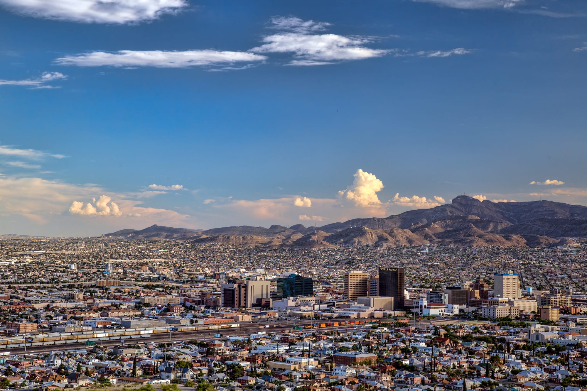
Downtown El Paso's towers rising from low city blocks and rail yards, with bare desert mountains on the horizon

Texas, United States

El Paso

El Paso seen from Scenic Drive on the slopes of the Franklin Mountains. (WmCheez / Wikimedia Commons · CC BY-SA 4.0)

The largest city in West Texas, on the Rio Grande directly across from Ciudad Juárez in Mexico, with the Franklin Mountains running through its middle. Spanish missions, a major army post and the railways made it the crossroads of the borderlands; today it is a largely Mexican American city where two countries meet every day.

Neighbourhoods

  • Downtown
    • First-time visitors
    • Museums
    • Close to public transport

    The old centre between the railway and the border, built around San Jacinto Plaza. Early 20th-century office towers, the restored Plaza Theatre, the art and history museums and the baseball park are all within a few blocks, and the shopping streets of El Segundo Barrio lead down to the bridges into Juárez.

    Open in Maps
  • Sunset Heights
    • Historic district
    • Quiet and residential

    A hillside neighbourhood just north-west of downtown, with older houses above the city and the river. Revolutionary exiles from Mexico lived here in the 1910s.

    Open in Maps
  • Kern Place and UTEP
    • Students and nightlife
    • Best for food

    A residential district of early 20th-century houses below the Franklin Mountains, beside the University of Texas at El Paso. Cincinnati Avenue has a cluster of bars and restaurants that fill with students and young professionals.

    Open in Maps
  • Westside
    • Quiet and residential
    • Shopping

    The newer suburbs west of the Franklin Mountains, along the Upper Valley of the Rio Grande, with shopping centres, chain restaurants and easy access to the mountain trails and New Mexico.

    Open in Maps
  • Lower Valley and the Mission Trail
    • Historic district
    • Local life

    The farming valley south-east of the centre, where the Ysleta and Socorro missions and the San Elizario chapel stand within a few miles of each other among farmland and small towns. The Tigua community of Ysleta del Sur Pueblo is here.

    Open in Maps

Things to do

Missions and history

  • Ysleta Missionlandmark

    A mission built in 1682 by Tigua people who had fled the Pueblo Revolt in New Mexico, recognised as the oldest continuously operated parish in Texas.

    Open in Maps
  • Socorro Missionlandmark

    An adobe mission church in the Lower Valley, rebuilt around 1839 after a Rio Grande flood, with painted ceiling beams made in 1691 by Piro craftsmen and reused from the earlier church.

    Open in Maps
  • San Elizariolandmark

    A small town that grew around a Spanish military post, with an old presidio chapel at the southern end of the Mission Trail.

    Open in Maps
  • Magoffin Homemuseum

    An 1870s adobe house built for a prominent El Paso family, preserved as a state historic site near downtown.

    Open in Maps
  • Chamizal National Memorialpark

    A park on the border marking the peaceful settlement in 1963 of a long dispute over land moved by the shifting course of the Rio Grande.

    Open in Maps

Museums

  • El Paso Museum of Artmuseum

    A downtown museum with European, American and Mexican collections, including Kress Collection paintings.

    Open in Maps
  • El Paso Museum of Historymuseum

    The city's history museum downtown, covering four centuries of life in the borderlands.

    Open in Maps
  • El Paso Holocaust Museum and Study Centermuseum

    A museum near downtown dedicated to the history of the Holocaust, founded in 1994 by the survivor Henry Kellen.

    Open in Maps
  • National Border Patrol Museummuseum

    A museum on the northern edge of the city telling the history of the US Border Patrol.

    Open in Maps

Mountains and parks

  • Franklin Mountains State Parkpark

    One of the largest urban parks in the United States, covering the desert range that splits the city, with trails and rock climbing.

    Open in Maps

Downtown landmarks

  • San Jacinto Plazalandmark

    The central square of downtown, known for its alligator sculpture, a reminder of the live alligators kept in its pond for decades.

    Open in Maps
  • Plaza Theatrelandmark

    A 1930 Spanish Colonial Revival movie palace, saved from demolition and restored as a performing arts venue.

    Open in Maps
  • University of Texas at El Pasolandmark

    A university campus known for buildings in a Bhutanese style, with sloping walls and dark bands under the roofs.

    Open in Maps

Short trips from the city

  • Hueco Tankspark

    A state historic site east of the city where rock basins once held rainwater, known for Native American rock paintings and for bouldering.

    Open in Maps
  • Mount Cristo Reyviewpoint

    A peak just across the line in Sunland Park, New Mexico, crowned by a limestone statue of Christ on the cross completed in 1939, a site of Catholic pilgrimage.

    Open in Maps

Seasonal events

  • Sun Bowllate December

    A college football bowl game played in El Paso since 1935, now held at the Sun Bowl stadium on the UTEP campus.

Eat and drink

Long-standing places and food districts in El Paso. Hours, ratings and directions come from your maps app, always current.

El Paso classics

  • Chico's Tacosrestaurant

    A local chain founded in the 1950s, known for rolled tacos served in a thin tomato broth and covered with shredded cheese.

    Open in Maps

Food districts

  • Downtown and El Segundo Barrioneighborhood

    Small cafés, bakeries and lunch counters in the old barrio near the border bridges, serving burritos, menudo and pan dulce.

    Open in Maps
  • Cincinnati Avenueneighborhood

    The short strip of bars and restaurants beside the UTEP campus, the liveliest place to eat and drink in the evenings.

    Open in Maps

Experience El Paso

History

The Rio Grande crossing here gave the city its name: El Paso del Norte, the pass of the north, where the Camino Real from Mexico City threaded between the mountains on its way to Santa Fe. In 1659 Spanish friars founded a mission on the south bank, in what is now Ciudad Juárez. After the Pueblo Revolt of 1680 drove Spanish colonists and allied Pueblo peoples south from New Mexico, the refugees founded the settlements of Ysleta and Socorro downstream, among the oldest in Texas; San Elizario grew up later around a Spanish presidio moved there in 1789.

After the Mexican–American War of 1846–1848 the river became the border, and the small settlements on the north bank grew into an American town. Fort Bliss was established in the area in the 1840s, and the arrival of several railways in 1881 turned El Paso into a rough boomtown of saloons, gunfights and trade. During the Mexican Revolution of the 1910s the city became a centre of intrigue, home to refugees and exiled leaders such as Victoriano Huerta.

In the 20th century El Paso grew with Fort Bliss, copper refining and garment factories, and a long dispute over land shifted by the river was settled with the Chamizal agreement of 1963. In 2019 a mass shooting at a Walmart store, targeting Hispanic shoppers, killed 23 people.

Culture & Customs

El Paso is shaped by the border more than any other large American city. Most residents are Hispanic, mainly of Mexican origin, and Spanish and English mix freely in homes, shops and on the radio. For generations families have lived, worked, studied and shopped on both sides of the river, and the city has often described itself, together with Juárez and Las Cruces, as one metropolitan region of more than two million people.

The Tigua of Ysleta del Sur Pueblo keep their own traditions, feast days and government, and are one of the oldest communities in the state. Catholic faith remains strong, from the old missions to the pilgrimages up Mount Cristo Rey. Day of the Dead is widely observed, and murals across the barrios depict Mexican and Chicano history, saints and local heroes.

The army is the other strong influence: Fort Bliss is one of the largest military installations in the country, and soldiers and their families are part of daily life. The Sun Bowl, UTEP basketball and the Chihuahuas minor-league baseball team draw loyal crowds. The city is the subject of Marty Robbins's 1959 ballad "El Paso", and El Pasoans are known for their friendliness and a relaxed pace.

Daily Life

About 680,000 people live in the city, which makes it the sixth largest in Texas. Fort Bliss, the school districts, the University of Texas at El Paso, hospitals, government work and cross-border trade are among the main employers. Trade across the international bridges with the factories of Juárez is a mainstay of the economy, and many El Pasoans work in logistics and customs.

The city spreads around the Franklin Mountains. The Westside and the north-east are suburban, with newer houses, shopping centres and easy mountain access; the Lower Valley keeps a more rural and traditional feel; and the old barrios near downtown remain the most Mexican in character. The Eastside has grown fastest, with new subdivisions stretching into the desert.

Wages are lower than the national average, and so is the cost of living. Water is a constant concern in the desert, and the city has invested in desalination of brackish groundwater. Immigration and border policy are everyday matters here rather than distant debates, affecting families, businesses and the waits at the bridges.

Food

El Paso's food is border Mexican, related to the cooking of Chihuahua and New Mexico more than to the Tex-Mex of San Antonio. Green and red chile sauces appear in many dishes. Chile con queso, melted cheese with roasted green chile, is a standard starter, and flat enchiladas, sometimes topped with a fried egg, are common. Caldillo, a beef and potato stew with green chile, is a cold-weather favourite.

Burritos are an everyday food, as in Juárez, often small and filled with a single stew such as chile colorado or chile verde. Rolled tacos served in a thin tomato broth and buried in cheese are a local speciality, and gorditas, tamales and menudo, a tripe soup eaten on weekend mornings, are found across the city. Panaderías sell pan dulce, sweet breads, and biscochos, the anise-flavoured cookies of Mexican celebrations.

Texas barbecue and steakhouses are also popular, and Mexican sodas and beers appear on many tables.

Planning tools

Budget

El Paso is one of the less expensive large cities in the United States. Hotels, Mexican food and petrol cost less than in Dallas, Austin or the big western cities. The main extra cost is a car, which most visitors need to reach the mountains and the missions.

Daily Budget Midrange
USD 150–280 (mid-range hotel, sit-down dinners, rental car and fuel, park and museum entries)
Daily Budget Shoestring
USD 70–120 (budget motel, taco and burrito lunches, buses)

Much of what draws visitors, from the missions to the plazas and the mountain views, costs little or nothing.

Best Time to Visit

October to April. Autumn and spring are warm and dry, and winter days are mild and sunny, though nights can be cold. Spring can be windy, with dust storms. June is usually the hottest month, and July to September bring the summer monsoon of afternoon thunderstorms.

Suggested Number of Days

Two days are enough for a first look at the city and its mountains. Add a day or two for the outlying historic sites and parks, which are spread across a wide area and need a car.

First Visit
2 days
With Surroundings
3–4 days

Transportation

El Paso is spread out and built around the car. Most visitors drive or use ride-hailing. Sun Metro runs city buses, including Brio rapid bus lines on the main corridors, which link downtown with the outer transfer centres. Interstate 10 crosses the city from east to west.

Rental cars from the United States often may not be taken into Mexico without special insurance and permission from the rental company.

Airport & Station Connections

El Paso International Airport is about 4 miles north-east of downtown. Amtrak's Sunset Limited and Texas Eagle stop at Union Depot downtown a few times a week. By road, the city lies on Interstate 10, the main highway across southern Texas and the South-West.

Walkability

Downtown is compact and walkable, with the plazas, museums and the ballpark close together, and the shopping streets lead south towards the border. Most other neighbourhoods are spread out along wide roads and freeways, and summer heat makes long walks uncomfortable.

Safety

El Paso has consistently had one of the lower violent crime rates among large American cities. Ordinary precautions are enough in most areas. Ciudad Juárez, across the river, has had much higher levels of violent crime linked to drug trafficking, so official advice should be checked before crossing.

Carry water and sun protection on mountain trails, and carry a passport if planning to cross into Mexico. Check current official travel advice before travelling.

Climate

A hot desert climate at about 3,700 feet above sea level, with abundant sunshine, low humidity and little rain outside the summer monsoon.

Summer
hot — afternoons are typically in the mid-90s °F and often pass 100°F in June, with thunderstorms from July
Winter
mild and sunny — days usually in the high 50s °F, with nights near or below freezing and occasional light snow

Local Customs

Most El Pasoans are of Mexican descent, and Spanish is heard as often as English; many people switch between the two. Life is closely tied to Juárez, with families, work and shopping on both sides. Tipping follows US norms: about 18–20 per cent in restaurants.

The legal drinking age is 21, and Texas sales tax is added at the till. Ask before photographing people or the border infrastructure.

Common Payment Methods

The currency is the US dollar. Cards and contactless payment are accepted almost everywhere, and ATMs are common. Some shops near the border accept Mexican pesos, but dollars are standard.