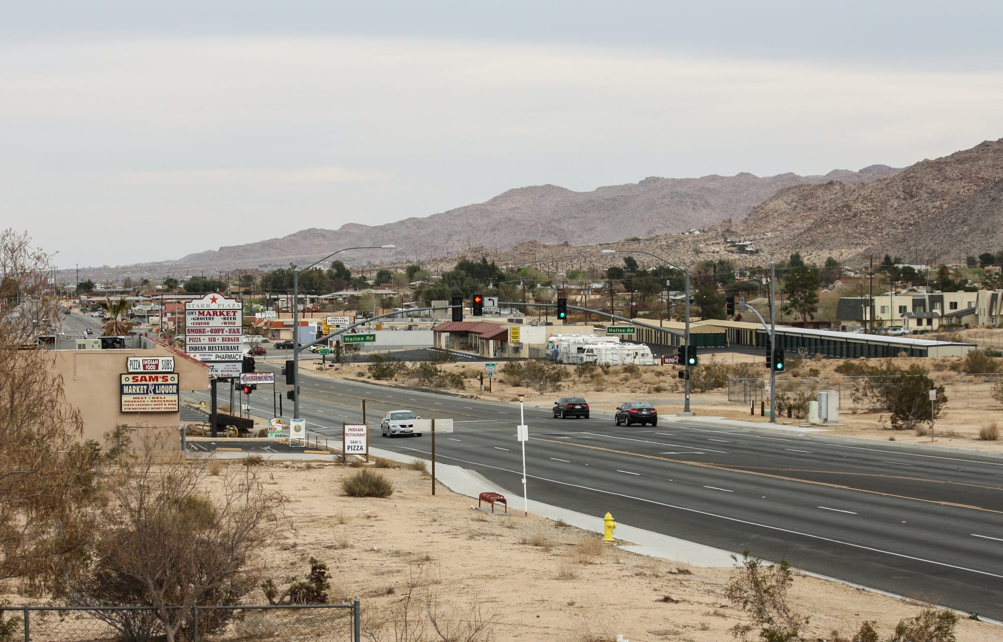
A wide highway running through a low desert town of roadside signs and small buildings below rocky brown hills

California, United States

Joshua Tree

Twentynine Palms Highway (State Route 62) through the town of Joshua Tree. (Bernard Gagnon / Wikimedia Commons · CC BY-SA 3.0)

A small, unincorporated desert community in San Bernardino County, strung along Highway 62 at the western entrance to Joshua Tree National Park. Settled by homesteaders in the 20th century, it has become a gateway town for climbers, hikers and stargazers and a home for artists and musicians drawn by the open Mojave landscape and its spiky Joshua trees.

Neighbourhoods

  • The Highway 62 strip
    • First-time visitors
    • Best for food
    • Shopping

    The town's commercial centre along Twentynine Palms Highway around the junction with Park Boulevard, with cafés, outdoor-gear and climbing shops, galleries, a grocery and the national park's visitor centre within a few blocks.

    Open in Maps
  • Park Boulevard and the south side
    • Close to the park
    • Quiet and residential

    The road south from the highway climbs gently through scattered houses and holiday rentals among Joshua trees and boulders to the park's west entrance, a few miles from town. It is quiet, dark at night and closest to the park.

    Open in Maps
  • The north side and the open desert
    • Stargazing
    • Quiet

    North of the highway, dirt roads lead to homestead cabins, artists' studios and desert houses spread across the flats towards Landers, with wide views and very dark skies.

    Open in Maps

Things to do

The park and the town

  • Joshua Tree National Parkpark

    Nearly 800,000 acres of desert where the Mojave and Colorado deserts meet, with forests of Joshua trees, huge piles of granite boulders, palm oases and thousands of named rock-climbing routes.

    Open in Maps
  • Noah Purifoy Outdoor Desert Art Museummuseum

    Ten acres of sculptures and assemblages built from found materials by the Los Angeles artist Noah Purifoy, who lived and worked here from 1989 until his death.

    Open in Maps

Short trips from the town

  • Integratronlandmark

    A 38-foot domed structure in Landers built in the 1950s by the ufologist George Van Tassel, now known for 'sound baths' in what its owners call an acoustically perfect chamber.

    Open in Maps
  • Pioneertownlandmark

    A Wild West film set built in the 1940s by Hollywood investors including Roy Rogers, where people still live among the false-fronted buildings.

    Open in Maps
  • Desert Christ Parkpark

    A 3.5-acre sculpture garden in neighbouring Yucca Valley of large steel-reinforced concrete biblical figures, begun by Antone Martin in the mid-1940s.

    Open in Maps
  • Twentynine Palmsneighborhood

    The town at the park's north entrance, with the Oasis of Mara and a park visitor centre beside it.

    Open in Maps
  • Palm Springs Aerial Tramwayattraction

    The world's largest rotating aerial tramway, climbing from the Coachella Valley to near the top of San Jacinto Peak above Palm Springs, about 29 miles south-west as the crow flies.

    Open in Maps

Seasonal events

  • Desert wildflower seasonlate winter and spring

    After wet winters the desert floor flowers in spring, and the Joshua trees themselves bloom with clusters of creamy flowers in some years.

  • Climbing seasonOctober to April

    The cool months bring climbers from around the world to the park's granite, filling campsites, climbing shops and guides' calendars.

Eat and drink

Long-standing places and food districts in Joshua Tree. Hours, ratings and directions come from your maps app, always current.

Joshua Tree classics

  • Crossroads Cafecafe

    A café on Twentynine Palms Highway serving breakfasts and simple meals to locals, climbers and park visitors.

    Open in Maps
  • Pappy and Harriet'srestaurant

    A Western-themed barbecue restaurant and live-music venue in the old film set at Pioneertown, run under this name since 1982.

    Open in Maps

Food districts

  • Highway 62 cafés and dinersneighborhood

    Cafés, groceries, taquerías, pizza and roadside diners spread along the highway between Yucca Valley, Joshua Tree and Twentynine Palms.

    Open in Maps

Experience Joshua Tree

History

The Serrano, Chemehuevi and Cahuilla peoples lived in and travelled through this desert, gathering food from its plants and water from its oases, such as the Oasis of Mara at Twentynine Palms. Ranchers grazed cattle among the boulders in the late 19th century, and miners worked gold claims in the hills, of which ruins and old mills survive in the park.

Settlement of the town itself came with homesteaders in the 20th century. In 1938 the federal Small Tract Act offered plots of up to five acres of desert land to citizens willing to build on them, and the scattered shacks of these "jackrabbit homesteads" still dot the land around the town.

The desert around the town was protected as Joshua Tree National Monument in 1936, largely through the efforts of Minerva Hoyt, a South Pasadena gardener and campaigner devoted to the desert's cactus and Joshua trees. It was enlarged and became a national park in 1994. The death of the country-rock musician Gram Parsons in a local motel in 1973, and U2's 1987 album The Joshua Tree, gave the place a counter-cultural fame that has grown with the park's visitor numbers.

Culture & Customs

Joshua Tree has long attracted people seeking space and quiet: artists, musicians, retirees, climbers and people living off the grid. Noah Purifoy's outdoor museum of assemblage art, the Integratron's sound baths and the many small galleries along the highway reflect a creative, slightly offbeat culture, and the wider Hi-Desert has a reputation for music, from the bar stage at Pioneertown to festivals held in the desert.

Climbing is a central part of local life. The park's granite boulders and domes draw climbers from around the world, especially in autumn and spring, and the climbing shops and guides in town are part of the community. Stargazing is another passion: the park is recognised as an International Dark Sky Park, and dark skies are prized by residents.

The Joshua tree itself, a giant species of yucca, is a symbol of the place, and its range is predicted to shrink and shift with climate change. Many residents see themselves as stewards of the desert, and care for its slow-growing plants and fragile soil is expected of visitors too.

Daily Life

About 6,500 people lived in Joshua Tree at the 2020 census. It is an unincorporated community governed by San Bernardino County, part of the Morongo Basin with Yucca Valley to the west and Twentynine Palms to the east, whose economy depends largely on the Marine Corps Air Ground Combat Center.

Tourism linked to the national park has grown sharply, and holiday rentals have become a visible part of the local economy. Other residents work in the Marine base's economy, in local services, in the arts, or commute to the Coachella Valley; many are retired.

Daily life is shaped by distance and climate. Errands mean drives along Highway 62, homes are spread over large plots of desert, and water and power are precious in the desert. Summer heat pushes activity into early mornings and evenings, while winter brings clear, cold nights. Debates centre on growth, holiday rentals, water and protecting the dark skies.

Food

The food scene in Joshua Tree is small and casual. Cafés along the highway serve breakfasts, sandwiches and coffee to climbers and park visitors before they head into the desert, and small groceries cater to the town's mix of residents and visitors. Taquerías and Mexican restaurants, pizza and roadside diners are common up and down Highway 62.

In nearby Pioneertown, a former film set, a barbecue restaurant and music venue built in a Western-style saloon has become a destination in its own right. Further afield, the Coachella Valley's date groves supply date shakes, the area's signature treat, sold in date gardens and cafés.

Inside the national park there is nothing to buy, so picnics and campsite cooking are part of every visit. Visitors stock up on water, fruit and snacks in town, and evenings at campsites revolve around simple meals cooked over stoves, followed by long looks at the night sky.

Planning tools

Budget

Joshua Tree is a gateway town with few services, and costs depend mostly on where people sleep. Holiday rentals and small motels fill up and charge more at weekends in spring and autumn; campsites inside the park are the cheapest option. A car is essential, and the national park charges a vehicle entry fee.

Daily Budget Midrange
USD 220–400 (desert rental or motel, café and diner meals, a hire car and fuel, park entry)
Daily Budget Shoestring
USD 80–150 (park campsite, groceries, park entry shared by car, free hiking and climbing)

Bring food and water into the park — there are no shops or restaurants inside it, and fuel is only available in the towns.

Best Time to Visit

October to May. Spring brings wildflowers and comfortable hiking days; autumn is the main climbing season; winter is cool and clear, with cold nights and occasional snow on the higher ground. From June to September daytime heat makes hiking dangerous, though summer nights are good for stargazing.

Suggested Number of Days

Two or three days are enough for the town and a first look at the park. Four or five allow time for the quieter southern desert, the neighbouring Hi-Desert towns and the Coachella Valley. Climbers often stay much longer.

First Visit
2–3 days
With Surroundings
4–5 days

Transportation

There is no public transport inside the park, and a car is needed to reach almost everything. Basin Transit buses run along Highway 62 between Yucca Valley, Joshua Tree and Twentynine Palms, with a link to Palm Springs International Airport. Distances in the desert are long, and phone signal is patchy.

Fill the tank and carry plenty of water before entering the park; download maps in advance, as phones often lose signal.

Airport & Station Connections

Palm Springs International Airport is about 40 miles south-west, an hour or so by car. Los Angeles International Airport is about 140 miles west, roughly two and a half to three hours by road on Interstate 10 and Highway 62. Almost all visitors arrive by car.

Walkability

The few blocks around the Highway 62 and Park Boulevard junction can be walked, but the rest of the community is spread over miles of desert with no pavements and fast traffic on the highway. Inside the park, hiking trails start at car parks along the main roads.

Safety

Joshua Tree is a quiet community. The serious risks are natural: heat illness and dehydration, getting lost off-trail among identical boulder piles, falls while scrambling or climbing, and flash floods in summer storms. Rattlesnakes and scorpions live in the desert, and roads at night are dark.

Carry far more water than seems necessary, tell someone the route, and avoid hiking in the heat of summer afternoons. Check current official travel advice before travelling.

Climate

A high desert climate, cooler than the low desert around Palm Springs. Rain is scarce, skies are usually clear, and the difference between day and night temperatures is large.

Summer
hot — July days are typically in the upper 90s °F or higher, with occasional monsoon thunderstorms in late summer
Winter
mild days and cold nights — January days are around 60°F, nights often near or below freezing

Local Customs

Tipping is expected: roughly 18–22 per cent in restaurants and cafés. The atmosphere is casual and creative, and many residents value quiet and dark skies. In the park, Joshua trees and other plants are protected, and park rules govern climbing and where pets may go.

Identification is asked for when buying alcohol (the legal age is 21). Keep outdoor lights off at night, respect private land along dirt roads, and stay on trails to protect fragile desert soil.

Common Payment Methods

The currency is the US dollar. Cards are widely accepted in town, and park entry can be paid by card at the entrance stations. ATMs are few, so some cash is useful for small businesses and campsites.