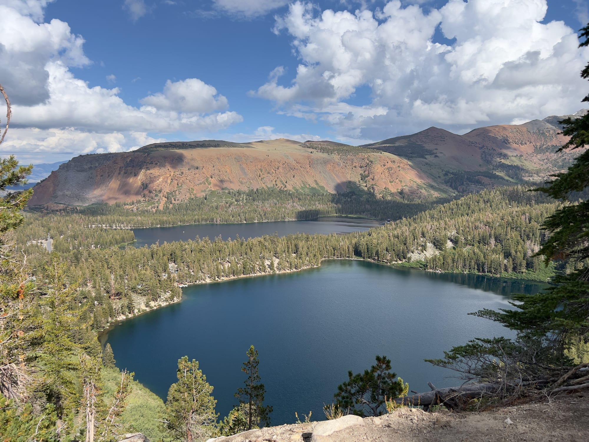
Two deep blue lakes ringed by pine forest below red and grey mountain slopes under white clouds

California, United States

Mammoth Lakes

Lake George, with Lake Mary beyond, in the Mammoth Lakes Basin above the town. (Srishti Sethi / Wikimedia Commons · CC BY-SA 4.0)

A mountain resort town on the eastern slope of the Sierra Nevada in Mono County, at about 7,900 feet. A short-lived mining camp in the 1870s, it grew around the ski area Dave McCoy built on Mammoth Mountain from the 1940s. Today it is a year-round base for skiing, lakes, fishing, mountain biking and the volcanic landscapes of the eastern Sierra.

Neighbourhoods

  • The Village
    • First-time visitors
    • Nightlife
    • Close to the gondola

    A pedestrian complex of shops, restaurants and condominium buildings at the corner of Main Street and Minaret Road, with a gondola up to the ski area in winter. It is the liveliest part of town in the evening.

    Open in Maps
  • Main Street and Old Mammoth Road
    • Local life
    • Best for food
    • Shopping

    The town's commercial spine along Highway 203 and the road south, lined with shops, outdoor-gear stores, restaurants, cafés and motels, much of it in low mountain-style buildings set back behind car parks.

    Open in Maps
  • Canyon Lodge and the ski-area edge
    • Skiing
    • Families

    The condominium districts on the west side of town around Canyon Lodge and Eagle Lodge, where some lifts start close to the town, popular with skiers who want to walk to the snow.

    Open in Maps
  • The Lakes Basin
    • Lakes and hiking
    • Fishing
    • Quiet

    A glacial basin a few miles above town along Lake Mary Road, with Twin Lakes, Lake Mary, Lake George and Horseshoe Lake among pine forest, a few lakeside cabin resorts and campgrounds, and trailheads into the high country. The road is closed by snow in winter.

    Open in Maps

Things to do

Mountain and lakes

  • Mammoth Mountainattraction

    A large ski area with 3,500 acres of skiable terrain on a lava dome rising to over 11,000 feet, with a season that typically runs from November to May.

    Open in Maps
  • Lake Marypark

    The largest lake of the Lakes Basin, used for boating and trout fishing in summer, with trails around its shores.

    Open in Maps
  • Horseshoe Lakepark

    A lake at the top of the Lakes Basin road, ringed by dead trees killed by carbon dioxide seeping from the volcanic ground below.

    Open in Maps
  • Convict Lakepark

    A lake below steep, striped peaks a short drive south of town, named after an 1871 shootout with escaped convicts, with a trail around its shore.

    Open in Maps

Devils Postpile

  • Devils Postpile National Monumentpark

    A cliff of tall basalt columns in the valley of the Middle Fork of the San Joaquin River, reached in summer by the Reds Meadow Road and a shuttle bus from the ski area.

    Open in Maps

Short trips from the town

  • Hot Creek Geological Sitepark

    A creek in a gorge about 8 miles east of the town, where hot springs flow into the stream; some springs spurt very hot water without warning, and parts of the gorge have been closed.

    Open in Maps
  • Mono Lakepark

    An ancient, salty lake about 25 miles north, ringed by limestone tufa towers and visited by huge numbers of migrating birds.

    Open in Maps
  • Tioga Passviewpoint

    The high pass into Yosemite National Park above Lee Vining, the highest highway pass in California, usually open from late spring to autumn.

    Open in Maps
  • June Lakepark

    A small resort community on a loop road of four lakes north of Mammoth, with its own ski area.

    Open in Maps
  • Bodie State Historic Parklandmark

    A gold-mining ghost town preserved in a state of 'arrested decay', with houses, a church and shops left much as they were abandoned.

    Open in Maps

Seasonal events

  • Ski and snowboard seasonNovember to late spring, sometimes into summer

    Mammoth's high elevation and heavy snowfall give it a long season, typically from November to May and in some years into the summer months.

  • Opening of Tioga Roadlate May to June, depending on snow

    The day the road over the pass reopens after the winter closure, linking the eastern Sierra with Yosemite Valley for the summer.

Eat and drink

Long-standing places and food districts in Mammoth Lakes. Hours, ratings and directions come from your maps app, always current.

Mammoth classics

  • Mammoth Brewing Companyrestaurant

    The town's craft brewery, founded in 1995 and one of the highest-elevation breweries on the West Coast of the United States, with its brewery and tasting room on Lake Mary Road.

    Open in Maps
  • Whoa Nellie Delirestaurant

    A restaurant inside a petrol station at the junction of the Tioga Road above Mono Lake, well known among travellers on the eastern Sierra route.

    Open in Maps

Food districts

  • The Villageneighborhood

    Restaurants and bars around the gondola station, busiest after the lifts close in winter.

    Open in Maps
  • Main Street and Old Mammoth Roadneighborhood

    Breakfast places, cafés, pizza and Mexican restaurants used by locals as well as visitors, spread along the town's two main roads.

    Open in Maps

Experience Mammoth Lakes

History

Paiute and other Native peoples lived in and travelled through the area long before European-American settlement. In 1877 four prospectors staked a claim on Mineral Hill, south of the present town, and in 1878 the Mammoth Mining Company was organised, setting off a gold rush. By the end of 1878 about 1,500 people lived in the camp of Mammoth City, but heavy snow, the company's closure in 1880 and a fire that year emptied it, and by 1888 fewer than ten people remained.

By the early 1900s a small settlement, now known as Old Mammoth, had grown up near Mammoth Creek, and the completion of Highway 203 in 1937 drew businesses north to the present town site. The modern town grew with skiing. Dave McCoy, a hydrographer for the Los Angeles water department, set up a rope tow on McGee Mountain in 1938 and one on Mammoth Mountain in 1942; he obtained a Forest Service permit for Mammoth in 1953 and opened the first chairlift in 1955. Paved roads and Highway 395 made the mountain reachable from Southern California, and lodges, motels and condominiums followed.

In 1980 a strong earthquake swarm and ground uplift beneath the Long Valley Caldera raised concerns about volcanic activity, and later carbon dioxide seeping from the mountain began killing trees around Horseshoe Lake. McCoy sold his stake in the ski area in 2005, and in 2017 it passed to the resort group Alterra, which runs it alongside other North American mountains.

Culture & Customs

Life here revolves around the mountain and the seasons. In winter the town is a ski resort of early starts, crowded lift lines on holiday weekends and après-ski in the Village; in summer it turns into a base for hiking, fishing, climbing and mountain biking. Many locals came for a season and stayed, and an outdoors identity — skiing, trail running, backcountry trips — runs through almost everything.

Most visitors come from Southern California, and Mammoth is the easiest major ski resort to reach from Los Angeles, a weekend destination reached by a long drive up Highway 395. Professional and Olympic snowboarders and skiers have trained here, and the terrain parks have hosted international competitions.

The wider eastern Sierra has a distinct culture of open space and small towns, with ranching in the valleys, Paiute communities and public land managed by the Forest Service, the National Park Service and the Los Angeles water department, whose aqueduct draws water from the region. Respect for the land — packing out rubbish, keeping food away from bears, staying on trails — is taken seriously.

Daily Life

About 7,000 people lived in Mammoth Lakes at the 2020 census, the only incorporated town in Mono County, but the number of people in town can multiply on holiday weekends when second-home owners and visitors arrive. Much of the housing is condominiums and holiday homes, and many properties stand empty for part of the year.

Tourism is the whole economy. The ski area, the restaurants, lodging, shops and outdoor guides employ most workers, many of them seasonal; numbers of staff swell in winter and drop in spring. Housing for workers is a persistent problem: at the 2020 census more than two-thirds of the town's homes were counted as vacant, and the growth of the ski area has pushed up housing costs.

Winter shapes daily routines: digging out cars, clearing roofs of snow, school and work arranged around storms. A big winter can bring snow banks higher than the houses. Summer is busy but relaxed, with locals on trails and lakes before work, and spring and autumn are quieter months when some businesses close and residents take their own holidays.

Food

Mammoth's food is mountain-town food: hearty breakfasts before the lifts open, burgers and pizza, Mexican restaurants, and bakeries and coffee shops serving skiers and hikers. Après-ski bars in the Village and along Main Street fill up when the lifts close, and the local craft brewery, founded in 1995, has its tasting room in town.

The eastern Sierra's ranching and fishing traditions show in steak and trout on menus; trout is stocked in many of the lakes and creeks, and some anglers cook their catch at campsites. Bishop, further south on Highway 395, is the nearest larger town.

Along Highway 395 a stop for food is part of the trip. North of town, the Whoa Nellie Deli in a petrol station at Lee Vining, above Mono Lake, has a reputation far larger than its setting would suggest. In summer, farmers' markets and outdoor events bring produce, barbecue and food trucks to town.

Planning tools

Budget

Mammoth is a ski resort and priced like one in winter: lift tickets, equipment hire and lodging near the lifts are the largest costs, and prices peak at holidays and weekends. Summer is cheaper and many of the best things — lakes, trails, the national monument and Mono Lake — cost little beyond park and shuttle fees and fuel.

Daily Budget Midrange
USD 300–550 (condominium or lodge room, a lift ticket or bike-park pass, sit-down dinners, a hire car)
Daily Budget Shoestring
USD 120–200 (campsite or shared condo, groceries and takeaways, town buses, hiking)

Many visitors drive up from Southern California and rent condominiums together, which cuts lodging costs considerably.

Best Time to Visit

December to April for skiing and snowboarding, with the most reliable snow from January to March. Late June to September for hiking, fishing, mountain biking and the drive over Tioga Pass, which depends on the road reopening after winter. Autumn brings golden aspens and quiet trails; May and November are shoulder months when much is closed.

Suggested Number of Days

Two to four days suit a ski weekend or a first summer visit. Five to seven allow time to explore the wider eastern Sierra, from the Mono Basin to the Owens Valley. Winter storms can close roads and add days to any plan.

First Visit
2–4 days
With Surroundings
5–7 days

Transportation

A car is the usual way to reach and explore the eastern Sierra. In town, Eastern Sierra Transit buses link the lodging areas, the Village and the lifts, and a gondola runs from the Village to Canyon Lodge. A mandatory summer shuttle carries visitors down to Devils Postpile, where private cars are restricted.

Carry snow chains in winter — chain controls are common on Highway 395 and the town's roads, and storms can close passes for days.

Airport & Station Connections

Most visitors drive: Highway 395 brings traffic from Los Angeles to the south and from Reno to the north. In summer the Tioga Road links the area to Yosemite and the Bay Area; in winter routes from the west mean long detours around the Sierra. Eastern Sierra Regional Airport at Bishop has seasonal flights to Los Angeles, San Francisco and Denver, and Mammoth Yosemite Airport has limited scheduled service.

Walkability

The Village and the streets around it are walkable, but the town is spread along its main roads with large gaps, and its altitude makes walking tiring for new arrivals. A network of paved paths, used by walkers and cyclists, links much of the town and climbs towards the Lakes Basin. Pavements and paths can be icy or snow-covered in winter.

Safety

Mammoth is a safe town. The hazards are natural: altitude sickness for new arrivals, winter driving, avalanches and tree wells off the groomed runs, sudden storms in the high country, and wildfire smoke in some summers. Black bears live in and around town and are attracted to food.

Drink water and rise slowly to altitude; never leave food in a car, and use bear-proof bins. Check current official travel advice before travelling.

Climate

A mountain climate with heavy winter snow and dry, sunny summers. Big Pacific storms can bury the town under several feet of snow at once, while summer brings short afternoon thunderstorms.

Summer
warm, dry days and cold nights — July highs average about 78°F and nights about 48°F
Winter
long and very snowy — about 21 days a year stay below 32 °F, a few nights drop below 0 °F, and snowfall averages about 206 inches a season

Local Customs

Tipping is expected: roughly 18–22 per cent in restaurants and a dollar or two a drink at a bar, and ski instructors and shuttle drivers are often tipped. Dress is casual and outdoors-oriented everywhere. On the slopes, the skier downhill has right of way.

Identification is asked for when buying alcohol (the legal age is 21). Pack out all rubbish on trails and keep to designated areas in the protected lands.

Common Payment Methods

The currency is the US dollar. Cards and contactless payment are accepted almost everywhere, and ATMs are found in the Village and on Main Street. A little cash is useful for tips and at trailhead fee stations.