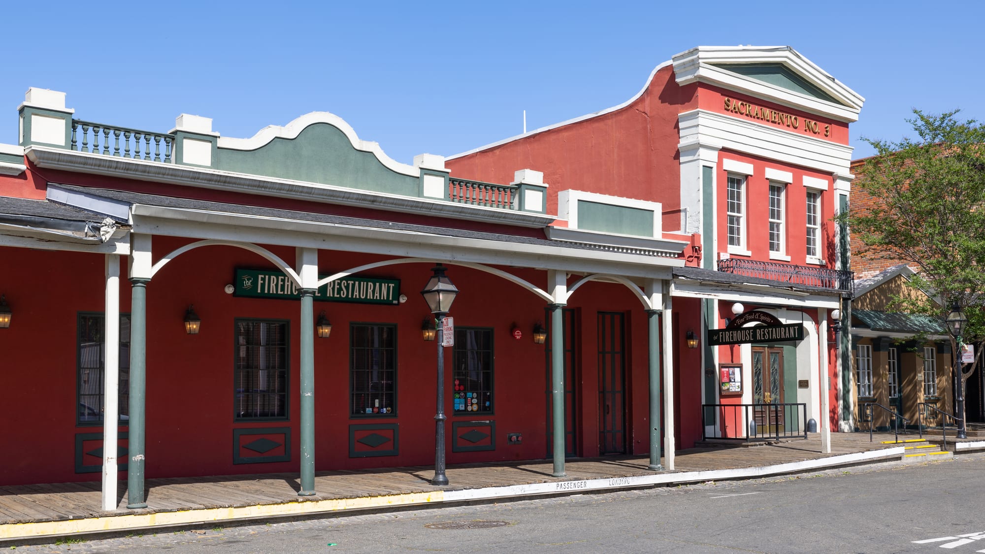
Red-painted 19th-century fire station and arcaded frontage with a wooden boardwalk and lamp posts in Old Sacramento

California, United States

Sacramento

Sacramento Engine Company No. 3 and its neighbours on 2nd Street in Old Sacramento. (Frank Schulenburg / Wikimedia Commons · CC BY-SA 4.0)

California's capital, at the meeting of the Sacramento and American rivers in the Central Valley. Born as the supply town of the 1848 Gold Rush and the starting point of the first transcontinental railroad, it is now a government city of tree-lined grids, restored gold-rush streets on the riverfront and a growing reputation for food drawn from the farms around it.

Neighbourhoods

  • Old Sacramento
    • First-time visitors
    • Historic district
    • Museums

    The gold-rush waterfront on the Sacramento River, a few blocks of restored 1850s and 1860s brick buildings with wooden boardwalks, raised after the floods of the 1860s. The railroad museum, riverboats and souvenir shops are here, and Tower Bridge leads across to West Sacramento.

    Open in Maps
  • Downtown
    • Government buildings
    • Sport and concerts
    • Close to public transport

    The grid of office towers between the river and the Capitol, with the Capitol Mall running up to the state building. The Golden 1 Center arena and the shops and bars of K Street are at its heart, and the light rail lines meet here.

    Open in Maps
  • Midtown
    • Best for food
    • Nightlife
    • Galleries

    East of the Capitol, a grid of Victorian and Craftsman houses under big street trees, mixed with restaurants, bars, coffee roasters and small galleries. It is the liveliest part of the city in the evening and the centre of the monthly Second Saturday art walk.

    Open in Maps
  • Land Park
    • Families
    • Quiet and residential
    • Parks

    A leafy residential district south of downtown, built around William Land Park with its zoo and golf course. Its edge on Broadway, by the Tower Theatre, has restaurants and cafés.

    Open in Maps
  • East Sacramento
    • Quiet and residential
    • Historic homes

    Tree-lined streets of large early 20th-century houses between Midtown and the American River, with the area known as the Fabulous Forties among its grandest. Sutter's Fort and McKinley Park are close by.

    Open in Maps
  • Oak Park
    • Local life
    • Best for food

    Sacramento's first suburb, south-east of downtown, once the end of four of the city's streetcar lines and with its own second downtown. Small restaurants, cafés and shops have opened around its main crossroads in recent years.

    Open in Maps

Things to do

Famous landmarks

  • California State Capitollandmark

    The domed Neoclassical seat of the state government, completed in 1874, with the historic offices of the governor and legislature open as a museum and the ten blocks of Capitol Park around it.

    Open in Maps
  • Tower Bridgelandmark

    A gold-painted vertical-lift bridge of 1935 over the Sacramento River, linking Old Sacramento with West Sacramento.

    Open in Maps
  • Sutter's Fortlandmark

    The adobe fort of John Sutter, its main building original and the rest reconstructed, the settlement from which the city grew, now a state historic park.

    Open in Maps
  • Leland Stanford Mansionlandmark

    The restored downtown home of the railroad magnate and governor Leland Stanford, used for state receptions.

    Open in Maps

Museums

  • California State Railroad Museummuseum

    A large museum of restored locomotives and carriages in Old Sacramento, near where the Central Pacific Railroad began building east in 1863.

    Open in Maps
  • Crocker Art Museummuseum

    Opened in 1885 in the Crocker family's Italianate gallery, it is one of the oldest art museums in the American West, with a strong collection of California art.

    Open in Maps
  • California Museummuseum

    A museum of the state's history and people beside the state archives, home to the California Hall of Fame.

    Open in Maps
  • Governor's Mansion State Historic Parkmuseum

    A Victorian house of 1877 that was home to California's governors for much of the 20th century.

    Open in Maps
  • California Automobile Museummuseum

    A collection of more than 150 classic cars, race cars, muscle cars and early models.

    Open in Maps

Parks and the rivers

  • American River Parkwaytrail

    A long green corridor along the American River with a paved cycling and walking trail running from Discovery Park out to Folsom.

    Open in Maps
  • William Land Parkpark

    A large city park with the zoo, a golf course, the Fairytale Town play park and the Funderland rides for young children.

    Open in Maps
  • Sacramento Zooattraction

    A mid-sized zoo inside William Land Park, opened in 1927.

    Open in Maps

Music, sport and nights out

  • Golden 1 Centerattraction

    The downtown arena of the Sacramento Kings basketball team, opened in 2016, which also holds concerts.

    Open in Maps
  • Sutter Health Parkattraction

    The riverside baseball park in West Sacramento, home of the minor-league Sacramento River Cats and the temporary home of Major League Baseball's Athletics until their Las Vegas stadium is ready.

    Open in Maps
  • Tower Theatrelandmark

    A 1938 cinema with a streamline moderne tower on Broadway, which gave its name to the Tower Records chain, whose original store was built into its side.

    Open in Maps

Short trips from the city

  • Marshall Gold Discovery State Historic Parkattraction

    At Coloma in the Sierra foothills, the site on the American River where James Marshall found gold in January 1848, with a replica of Sutter's sawmill.

    Open in Maps
  • Folsom Lakepark

    A reservoir on the American River north-east of the city, used for boating, swimming and lakeside trails.

    Open in Maps
  • Davisattraction

    A university town to the west, home of the University of California, Davis, and known for its cycling culture.

    Open in Maps

Seasonal events

  • California State FairJuly (from 2027, mid-September to early October)

    The state's annual fair at Cal Expo, with livestock and farm exhibits, rides and concerts.

  • Second Saturdaythe second Saturday of every month

    An evening art walk when Midtown's galleries open late and the streets fill with visitors.

  • AftershockOctober

    A large rock festival held since 2012 in Discovery Park, where the American River meets the Sacramento.

  • California International MarathonDecember

    A marathon run from Folsom Dam into the city on a net downhill course, ending at the State Capitol.

Eat and drink

Long-standing places and food districts in Sacramento. Hours, ratings and directions come from your maps app, always current.

Sacramento classics

  • Tower Cafecafe

    A café on Broadway in the Land Park area, near the Tower Theatre.

    Open in Maps

Food districts

  • Midtownneighborhood

    Restaurants, bars and cafés among the Victorian streets, busiest on Second Saturday evenings when they stay open late for the art walk.

    Open in Maps
  • Old Sacramentoneighborhood

    Restaurants and bars in the historic waterfront buildings, among them one in a red-brick firehouse of 1853.

    Open in Maps
  • Broadwayneighborhood

    A commercial street on the northern edge of Land Park with restaurants of many cuisines, Vietnamese among them.

    Open in Maps

Experience Sacramento

History

The Nisenan and Plains Miwok peoples lived along the Sacramento and American rivers for perhaps thousands of years before Europeans arrived. In 1839 the Swiss-born John Sutter, granted the task of colonising the valley by the Mexican governor, settled at the river junction and called his colony New Helvetia. In January 1848 James Marshall, building a sawmill for Sutter upstream at Coloma, found gold, and by the end of the year Sutter's son and the merchant Sam Brannan were laying out a city on the riverbank two miles south of the fort. Sacramento was incorporated in 1850, a year of flooding, cholera and a squatters' riot over Sutter's land claims.

Floods shaped the city. After the great flood of 1861–62 the business district was raised by a storey, leaving buried ground floors beneath Old Sacramento. Sacramento became the permanent state capital in 1854 and was the western end of the Pony Express in 1860. In 1863 the Central Pacific Railroad, financed by four of its merchants — Leland Stanford, Collis Huntington, Mark Hopkins and Charles Crocker — began building east from the city, completing the first transcontinental line in 1869.

In the 20th century government grew into the largest sector of employment, and military bases and aerospace work added jobs until the base closures of the 1980s and 1990s. The wartime incarceration of Japanese Americans devastated the city's Japantown, and redevelopment for the Capitol Mall later cleared much of the old West End. Old Sacramento was restored from the 1960s onwards, and in the 21st century new housing, the downtown arena and a revived Midtown have brought more people to live in the centre.

Culture & Customs

Sacramento's identity is bound up with government and farming. The Capitol, the courts and the state offices give weekdays their rhythm, while the farms of the Central Valley — rice, tomatoes, almonds, asparagus and wine grapes — supply the city's restaurants, and since 2012 it has promoted itself as America's Farm-to-Fork Capital. It is also known as the City of Trees, and its canopy of street trees shades most of the older neighbourhoods.

In 2002 a Harvard study for Time magazine named Sacramento America's most diverse city. It has large Mexican American, Asian American and Black communities, and its metropolitan area holds one of the country's largest Hmong communities and a large Ukrainian one. Tower Records began in Sacramento, the alternative metal band Deftones come from the area, and Greta Gerwig's film Lady Bird is set in the city she grew up in.

The Kings, the city's National Basketball Association team since 1985, are followed fiercely, and the city fought off a move to Seattle in 2013. Minor-league baseball draws crowds across the river in West Sacramento, where Major League Baseball's Athletics are playing temporarily until their Las Vegas stadium is ready. Midtown's Second Saturday art walk, the State Fair and summer evenings along the rivers are the local gatherings. Sacramentans are relaxed and informal, and often weary of being described as a stopover between San Francisco and Lake Tahoe.

Daily Life

About 525,000 people live in the city at the 2020 census, and nearly 2.5 million in the wider metropolitan area, which spreads into suburbs such as Elk Grove, Roseville and Folsom. Government, state and federal, is the largest sector of employment, alongside hospitals and health systems, the UC Davis Medical Center and California State University, Sacramento, and a technology and logistics sector in the suburbs.

The central grid holds the older neighbourhoods — Midtown, Land Park, East Sacramento, Curtis Park and Oak Park — with porches, bungalows and Victorian houses under heavy shade. Further out, post-war and newer suburbs dominate, and most households depend on a car. Much of the city's growth comes from people moving from the San Francisco Bay Area and from immigration from Asia and Latin America.

Homelessness, the cost of housing and flood protection are the issues most discussed. The city sits at the meeting of two large rivers, is counted the second most flood-prone city in the United States after New Orleans, and is protected by a long system of levees, and wet winters bring regular attention to their strength. Summer days are spent early and late to avoid the heat, with afternoons on the river, at a pool or indoors.

Food

Sacramento's food begins with what grows around it. The Sacramento Valley and the Sacramento–San Joaquin Delta produce rice, almonds, walnuts, tomatoes, asparagus and wine grapes, and many restaurants buy from the surrounding farms. Certified farmers' markets run year-round, among them one of the largest in California under the freeway downtown on Sunday mornings, and the city holds an annual Farm-to-Fork festival of growers, grocers and restaurants.

The city's mix of communities shows on its menus. Mexican taquerías and bakeries are everywhere, and Chinese, Vietnamese, Hmong and other Asian cooking reflects the large Asian communities of the city and its suburbs. The Gold Rush brought Chinese immigrants early, and Chinese restaurants have long been part of the city's dining.

Wine comes from the foothills of El Dorado and Amador counties, from Lodi to the south and from Clarksburg in the Sacramento Valley, and Midtown's bars and cafés are the centre of the city's drinking and coffee. Summer brings peaches, cherries and tomatoes at their best, and the region's farm produce is the theme of much of the city's cooking.

Planning tools

Budget

Sacramento is noticeably cheaper than San Francisco or Los Angeles for hotels and food, though prices are still Californian. Rooms are dearer during legislative weeks, big concerts and the State Fair. A hire car is useful for the foothills and the wider valley, but the central districts can be managed without one.

Daily Budget Midrange
USD 230–420 (central hotel, sit-down dinners, museum tickets, ride-hailing or a hire car)
Daily Budget Shoestring
USD 100–160 (hostel bed or budget motel, tacos and market food, light rail and buses)

Capitol Park, the riverfront and the American River Parkway trail cost nothing to visit; most museums and the state historic parks charge entry.

Best Time to Visit

Spring (March to May) and autumn (September to November) are the most comfortable, with warm days, cool evenings and the city's trees in leaf or colour. Summer is hot and dry, with many days in the 90s °F and occasional wildfire smoke, though the evening breeze from the Delta brings relief. Winter is mild and rainy, with spells of thick tule fog.

Suggested Number of Days

One or two days covers the centre and its museums. Three or four allow for the gold country of the Sierra foothills, the Delta and the nearby wine districts, which need a car. Summer heat slows the pace of a visit.

First Visit
1–2 days
With Surroundings
3–4 days

Transportation

Sacramento is a driving city, but the centre is easy without a car. SacRT light rail lines meet downtown and run out to the suburbs and Folsom, and buses cover the rest of the city. The flat grid and the river trails make cycling practical for much of the year, and ride-hailing is widely used.

Downtown and Midtown follow the original grid of lettered and numbered streets, which makes addresses easy to find.

Airport & Station Connections

Sacramento International Airport is about 10 miles north-west of downtown, typically 15–25 minutes by car or ride-hailing. The Sacramento Valley Station by Old Sacramento has Amtrak Capitol Corridor trains to the Bay Area as well as long-distance trains to Chicago and along the West Coast. Interstate 80 links the city with San Francisco and with Reno and Lake Tahoe across the Sierra Nevada.

Walkability

The central grid is flat and shaded by street trees, so Old Sacramento, downtown, the Capitol and Midtown can be covered on foot; the Capitol to Old Sacramento is about a mile. Land Park, East Sacramento and Sutter's Fort are within cycling distance. Summer afternoons are often too hot for long walks.

Safety

Most visits are trouble-free. As in many Californian cities, car break-ins and other property crime are the main problem, and homelessness is visible downtown and along parts of the river parkway. The rivers are the less obvious hazard: the American River runs cold and fast in spring and early summer and can be dangerous to swimmers.

Leave nothing in a parked car, wear a life jacket on the rivers and take heat and wildfire-smoke warnings seriously in summer. Check current official travel advice before travelling.

Climate

A hot-summer Mediterranean climate: long, dry, sunny summers and mild, wet winters, with nearly all the rain falling between November and March. Afternoon winds from the Delta cool summer evenings.

Summer
hot and dry — about 76 days a year reach 90 °F and about 14 reach 100 °F
Winter
mild and damp — December averages about 47 °F, with around 15 freezing nights a year, rain and dense tule fog that keeps days below 50 °F

Local Customs

Tipping is expected: roughly 18–20 per cent in restaurants and a dollar or two a drink in bars. Sales tax is added at the till. Dress is casual even in good restaurants, and the city's government workforce gives weekday lunchtimes downtown a busy, business-like air. Locals take pride in the nickname 'City of Trees' and in the farms of the valley.

The legal age for buying alcohol is 21, and identification is checked. Cannabis is legal for adults in California but may not be used in public places.

Common Payment Methods

The currency is the US dollar. Cards and contactless payment are accepted almost everywhere, including on light rail ticket machines and most parking machines. ATMs are easy to find; a little cash helps at farmers markets and small food stands.