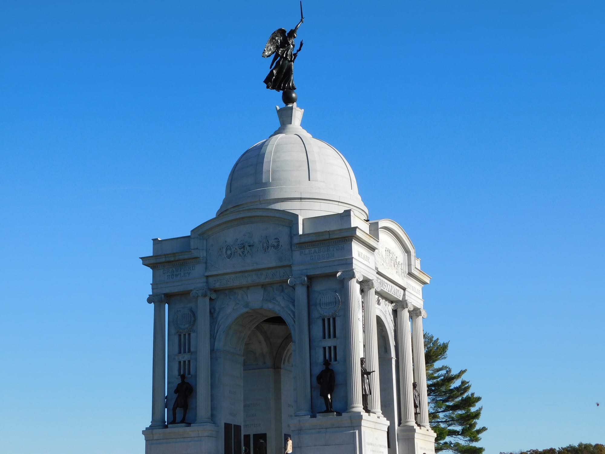
The domed granite Pennsylvania State Memorial on Cemetery Ridge, topped by a bronze winged figure, under a clear blue sky

New York & the Mid-Atlantic, United States

Gettysburg

The Pennsylvania State Memorial on Cemetery Ridge, the largest of the state monuments on the Gettysburg battlefield. (LeapingLion / Wikimedia Commons · CC BY-SA 4.0)

A small county town in the orchard country of south-central Pennsylvania, near the Maryland line, where the bloodiest battle of the American Civil War was fought over three days in July 1863 and where Abraham Lincoln gave the Gettysburg Address four months later. The battlefield surrounds the town on three sides, and visiting it — on foot, by car or with a licensed guide — is why most people come.

Neighbourhoods

  • Lincoln Square and downtown
    • First-time visitors
    • Historic district
    • Best for food

    The town centre, a square where many roads meet, with the David Wills House where Lincoln slept, brick 18th- and 19th-century buildings still carrying bullet holes, restaurants, shops and the old railway station. The centre is walkable in minutes.

    Open in Maps
  • Baltimore Street and Steinwehr Avenue
    • Close to the battlefield
    • Families
    • Nightlife

    The two streets running south from the square towards the National Cemetery and the museum, lined with the Jennie Wade House museum, ghost-tour offices, souvenir shops, taverns and the town's biggest cluster of hotels and family restaurants.

    Open in Maps
  • Seminary Ridge and the college
    • Quiet and residential
    • Walks
    • Students

    The western edge of town, where the Lutheran seminary's 1832 Schmucker Hall — now the Seminary Ridge Museum — and the leafy campus of Gettysburg College stand on the ridge where the fighting of 1 July ended. Quiet streets of old houses between them.

    Open in Maps
  • The battlefield
    • History
    • Walks and viewpoints
    • Cycling

    Not a neighbourhood but the setting: about 3,800 acres of park land, with fields, woods, ridges and stone walls wrapped around the south and west of the town, crossed by park roads, dotted with more than 1,300 monuments and best taken slowly over a day or more.

    Open in Maps

Things to do

The battlefield

  • Gettysburg National Military Parkpark

    The preserved battlefield of 1–3 July 1863, with a signed auto tour, licensed battlefield guides, walking trails and monuments to the regiments of both armies.

    Open in Maps
  • Gettysburg Museum and Visitor Center and the Cycloramamuseum

    The park's museum of the battle and the war, opened in 2008, with the restored Gettysburg Cyclorama, a 377-foot circular painting of Pickett's Charge completed by Paul Philippoteaux in 1883.

    Open in Maps
  • Little Round Topviewpoint

    The rocky hill at the southern end of the Union line, held on 2 July by the 20th Maine among others, with wide views over the battlefield and the boulders of Devil's Den below.

    Open in Maps
  • Devil's Denattraction

    A jumble of huge boulders below Little Round Top used by Confederate sharpshooters on 2 July to fire on Little Round Top.

    Open in Maps
  • Pennsylvania State Memoriallandmark

    The largest of the state monuments, a domed granite structure on Cemetery Ridge dedicated in 1910 and listing the names of about 34,500 Pennsylvanians who fought, with a spiral staircase to an observation deck.

    Open in Maps
  • The High Water Mark and the Anglelandmark

    The clump of trees and stone wall on Cemetery Ridge where Pickett's Charge broke on 3 July, marked by a monument with a large bronze tablet.

    Open in Maps
  • Eternal Light Peace Memoriallandmark

    A monument on Oak Hill with a gas flame, dedicated by Franklin Roosevelt in 1938 before veterans of both sides on the battle's 75th anniversary.

    Open in Maps

Lincoln and the town

  • Gettysburg National Cemeterylandmark

    The burial ground for more than 3,500 Union dead, laid out in arcs around the Soldiers' National Monument, where Lincoln delivered the Gettysburg Address at its dedication on 19 November 1863.

    Open in Maps
  • David Wills Housemuseum

    The house in the town centre where the lawyer who organised the cemetery hosted Lincoln the night before the address, now a museum with the bedroom where he finished the speech.

    Open in Maps
  • Gettysburg Railroad Stationtransit hub

    The 1858 station on Carlisle Street where Lincoln arrived and departed, used as a hospital after the battle and now a visitor site.

    Open in Maps
  • Jennie Wade Housemuseum

    The house on Baltimore Street where the only civilian killed in the battle was shot by a stray bullet through the kitchen door while baking bread, kept much as it was.

    Open in Maps
  • Seminary Ridge Museummuseum

    In Schmucker Hall, the seminary building used as an observation post and then a hospital in 1863, with exhibits on the fighting of 1 July, the wounded and the faith of the time, and a cupola view of the field.

    Open in Maps
  • Evergreen Cemetery gatehouselandmark

    The brick gatehouse of 1855 on Cemetery Hill that gave the hill its name and served as a Union corps headquarters, beside the town cemetery where Jennie Wade is buried.

    Open in Maps

Short trips from the town

  • Eisenhower National Historic Sitemuseum

    The farm beside the battlefield where President Dwight Eisenhower and his wife Mamie retired, with the house and farm preserved, reached by shuttle from the park visitor centre.

    Open in Maps
  • Sachs Covered Bridgelandmark

    A wooden covered bridge of 1854 over Marsh Creek a few miles south-west, crossed by both armies in 1863.

    Open in Maps
  • Caledonia State Parkpark

    About 15 miles west in the South Mountain, a park of woods, trails and a swimming pool on the site of Thaddeus Stevens' ironworks, crossed by the Appalachian Trail.

    Open in Maps
  • Hanoverattraction

    A small city about 15 miles east known for its snack-food factories — pretzels and potato chips — and a Civil War cavalry fight of its own the day before Gettysburg.

    Open in Maps
  • Antietam National Battlefieldpark

    About 40 miles south-west in Maryland, the site of the bloodiest single day of the war in September 1862, quieter and less built-up than Gettysburg.

    Open in Maps
  • Frederickattraction

    A handsome Maryland city about 35 miles south with a long brick historic district, the National Museum of Civil War Medicine and a good restaurant scene.

    Open in Maps

Seasonal events

  • Battle anniversaryearly July

    Ranger programmes, living-history camps on the battlefield and reenactments nearby mark the three days of the battle, the town's busiest week.

  • National Apple Harvest Festivalautumn

    An annual festival of the apple harvest in the orchard villages of the Fruit Belt north of the town.

  • Dedication Day and Remembrance Daymid-November

    Ceremonies in the National Cemetery on the anniversary of the Gettysburg Address, with a parade of Civil War reenactors through the town.

Eat and drink

Long-standing places and food districts in Gettysburg. Hours, ratings and directions come from your maps app, always current.

Gettysburg classics

  • Dobbin House Tavernrestaurant

    A stone house of 1776, the oldest standing building in the town, now a tavern and restaurant in a historic setting; it may have been a stop on the Underground Railroad, though this is unproven.

    Open in Maps
  • Adams County apples and cidermarket

    The countryside north of the town is Pennsylvania's Fruit Belt, with thousands of acres of apple and peach orchards, and farm markets, orchards and cideries in the countryside north and west of the town sell apples, cider, apple butter and pies from late summer.

    Open in Maps

Food districts

  • Lincoln Square and the centreneighborhood

    The square and the streets off it hold the town's pubs, a brewery taproom, cafés and a few serious restaurants in old brick buildings, where townspeople and college students eat alongside visitors.

    Open in Maps
  • Steinwehr Avenueneighborhood

    The tourist strip between the town and the museum: family restaurants, ice cream, taverns and diners near the hotels.

    Open in Maps

Experience Gettysburg

History

James Gettys, son of the Irish settler Samuel Gettys, laid out the town in 1786 on his father's land at a crossroads in the fertile country north of the Maryland line, and it became the seat of the new Adams County in 1800. Roads converging on its square from many directions made it a market town for the surrounding farms, and in the 1830s two institutions gave it a second character: a Lutheran theological seminary, founded in 1826 and moved to the ridge west of town in 1832, and Pennsylvania College, now Gettysburg College, founded in 1832. A railway arrived in 1858, and the town had about 2,400 people.

Those converging roads brought the armies. In late June 1863 Robert E. Lee's Confederate army was moving through Pennsylvania, and on 1 July its advance met Union cavalry west of the town. Over three days the two armies fought across the ridges and fields south and west of Gettysburg, with the Union army under George Meade holding the high ground from Cemetery Hill to the Round Tops and repelling Pickett's Charge on 3 July. Roughly 50,000 men were killed, wounded or captured, the largest toll of any battle in the war, and the town became a vast hospital. One civilian, Jennie Wade, was killed. On 19 November Lincoln spoke for about two minutes at the dedication of the Soldiers' National Cemetery.

Veterans' associations began marking the field within a few years, regimental monuments followed from the 1880s, and the federal government took over the battlefield in 1895. Tourism has been the town's business ever since, growing with the automobile and with the Eisenhowers, who bought a farm beside the field in 1950. A new park museum opened in 2008. Today about 7,000 people live in the borough.

Culture & Customs

Gettysburg lives with history in a way few American towns do. Bullet scars remain in the brick of Baltimore Street, licensed battlefield guides lead visitors over the field, and reenactors in wool uniforms are an ordinary sight on the square. The town takes the battle seriously: the field and the cemetery are treated as sacred ground, the annual Remembrance Day in November is a civic event with a parade, and residents are patient with the many visitors who arrive each year.

Beneath the Civil War layer is a Pennsylvania Dutch and Scots-Irish county seat of long standing, with a courthouse, a Lutheran seminary that still trains ministers, and a liberal-arts college of about 2,100 students whose concerts, lectures and sports add to the town's life. Adams County is apple country, and the orchards' calendar — blossom in spring, harvest festival in autumn — matters as much to locals as the battle anniversary does to visitors. Local manners are small-town and courteous, politically more conservative than the college, and proud of the place without being solemn.

The town also has a lighter commercial culture of ghost tours, of souvenir shops and of family attractions on Steinwehr Avenue, which purists grumble about and most visitors enjoy. Civil War round tables, collectors and historians make Gettysburg a year-round centre of study, and the bookshops are unusually good for a town of its size.

Daily Life

About 7,000 people live in the borough of Gettysburg, with roughly 100,000 in Adams County; the college's students make up a large share of the town's population during term. Tourism — the park, the museums, hotels, restaurants and guiding — is the biggest employer alongside the college, the seminary, the county government and the hospital, and the county's orchards and farms employ many more; the town also has a growing Latino community.

The town is a tight grid of brick and frame houses around the square, with newer housing and most of the hotels, motels and chain restaurants along the approach roads, and with the battlefield fixing a hard edge to growth on the south and west. Residents commute to Hanover, York and Harrisburg as well as working locally.

Daily life has a strong seasonal pattern: summer and October weekends are crowded and parking is hard, while January is empty and the shops on the square are quiet. Tourist traffic through the historic centre, the balance between preservation and business, and the park's management of the field are the perennial local debates. Beyond them, it is an ordinary Pennsylvania county town of high-school football and church suppers.

Food

The food is Pennsylvania Dutch and farm country, with the Civil War as decoration. Chicken pot pie here is a stew with thick homemade noodles and potatoes rather than a pastry pie; scrapple, chicken corn soup, shoofly pie and whoopie pies appear on diner and church-supper menus, and the county's orchards supply apple butter, cider, apple dumplings and pies from late summer, sold at farm markets along the roads north and west of town.

The Dobbin House, a stone house of 1776 and the oldest standing building in Gettysburg, is now a tavern and restaurant; several other inns and taverns around the square and on Baltimore Street trade on 18th- and 19th-century settings, and a brewery taproom and a handful of modern restaurants serve the college and the townspeople. Steinwehr Avenue has the family restaurants, ice cream and diners near the hotels, and the summer evening ritual is ice cream after a day on the field.

Drink runs to local craft beer, Adams County hard cider and wine from the vineyards of the orchard country. Nearby Hanover's snack factories mean Pennsylvania pretzels and potato chips are a point of local pride.

Planning tools

Budget

Gettysburg is good value by Mid-Atlantic standards. Hotels and motels along the approach roads are plentiful and cheap outside peak weeks; bed-and-breakfasts in the historic houses cost more. The battlefield itself is free to drive and walk, with charges for the museum, the cyclorama and a licensed guide, which is the one worthwhile splurge. Prices rise sharply for the battle anniversary in early July and autumn weekends.

Daily Budget Midrange
USD 200–350 (historic inn or bed-and-breakfast, restaurant dinners with tax and tip, museum and cyclorama tickets, a licensed guide shared, rental car)
Daily Budget Shoestring
USD 90–140 (motel or campground, diners and pizza, driving the free auto tour)

Book a licensed battlefield guide in advance for summer and autumn weekends; a two-hour car tour with one is the best way to understand the field.

Best Time to Visit

April to early June and September to October are the pleasant seasons: mild weather, green or turning fields and manageable crowds. July is hot, humid and busiest around the battle anniversary; August is hot and quieter. Winter is cold but the field is empty and atmospheric, and mid-November brings the Address anniversary ceremonies.

Suggested Number of Days

One full day covers the museum and the battlefield by car; two allow walking the key ground and the town's own museums. Three days leave room for the farms and orchards around the town as well.

First Visit
1–2 days
With Surroundings
3 days

Transportation

A car is the practical way to see the battlefield's 24-mile auto tour and the surrounding country. Bus tours also cover the field, licensed guides lead tours, and bikes can be hired and horseback tours booked for the park. The town centre is easily walked.

Park roads are narrow and shared with cyclists and walkers — drive slowly, and expect the auto tour to take three hours or more with stops.

Airport & Station Connections

Gettysburg has no airline or passenger train service. Harrisburg International Airport is about 47 miles away and Baltimore/Washington International about 62 miles; Washington Dulles is about 78 miles. By road the town is about 75 miles from Washington and 55 from Baltimore and about two and a half hours from Philadelphia, with limited bus connections via Harrisburg.

Walkability

The town is small and flat: Lincoln Square, Baltimore Street, the railway station, the college and the National Cemetery are all within a mile. The museum and visitor centre is about a mile south of the square, walkable by pavement. The battlefield is far too large to walk in full, but Little Round Top, Devil's Den, the Angle and the cemetery have short trails from their car parks.

Safety

A safe small town. The risks are practical: summer heat and thunderstorms on the open field, deer ticks in the long grass and woods, traffic on the park roads, and slippery boulders at Devil's Den and Little Round Top. Winter brings ice and occasional heavy snow.

Carry water and check for ticks after walking the field, keep children off the high boulders, and give cyclists and walkers room on the park roads. Check current official travel advice before travelling.

Climate

A humid continental climate with four clear seasons: hot, humid summers with thunderstorms, mild and colourful autumns, cold winters with some snow and wet springs.

Summer
hot and humid — July highs in the mid-80s °F, often higher on the open battlefield
Winter
cold — January highs in the high 30s °F, nights in the low 20s, with snow a few times each winter

Local Customs

Tipping is expected: 18–22 per cent in restaurants, a dollar or two a drink. Pennsylvania adds a 6 per cent sales tax, though not on most clothing. The battlefield and the cemetery are treated as hallowed ground: climbing on monuments, removing relics and metal detecting are prohibited, and quiet is expected in the cemetery. The town is small, conservative and polite, with a college and a long tradition of welcoming visitors.

The drinking age is 21; spirits are sold only in state-run Fine Wine & Good Spirits stores, and beer by distributors and, in limited amounts, some supermarkets.

Common Payment Methods

The currency is the US dollar. Cards and contactless payment are accepted nearly everywhere, including by the national park and the licensed guides, and ATMs are on and around the square. A little cash is useful at farm stands and orchards.