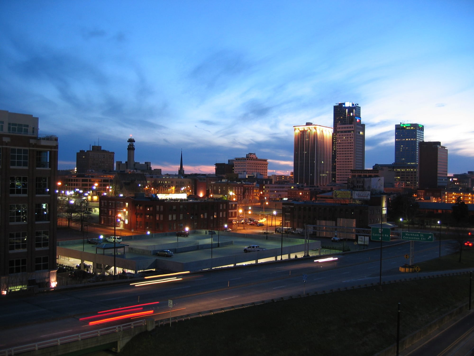
Downtown Little Rock's office towers lit at dusk under a streaked blue sky, with brick warehouses and a freeway in the foreground

The South, United States

Little Rock

The downtown Little Rock skyline at dusk, seen from the River Market district. (Bruce W. Stracener / Wikimedia Commons · Public domain)

The capital and largest city of Arkansas, on the south bank of the Arkansas River where the Ouachita foothills meet the Delta plain. A steamboat landing named for a rock outcrop, it became the state's political centre, the scene of the 1957 Central High School desegregation crisis and Bill Clinton's political home; today it is a government, medical and business city with a riverfront of parks, bridges and the Clinton presidential library.

Neighbourhoods

  • Downtown and the River Market
    • First-time visitors
    • Museums
    • Nightlife

    The riverside blocks east of Main Street where old warehouses hold the market halls, bars, restaurants and the city's main hotels, with Riverfront Park, the Clinton library and the Arkansas Museum of Fine Arts a short walk away.

    Open in Maps
  • Quapaw Quarter and MacArthur Park
    • Historic district
    • Quiet and residential
    • Architecture

    The city's oldest residential district south-east of downtown, with antebellum and Victorian houses, the Governor's Mansion and the arsenal in MacArthur Park where General Douglas MacArthur was born.

    Open in Maps
  • Hillcrest
    • Best for food
    • Quiet and residential

    An early 20th-century streetcar suburb on the hills west of the Capitol, with bungalows, old trees and a strip of cafés, restaurants and shops along Kavanaugh Boulevard.

    Open in Maps
  • The Heights
    • Shopping
    • Best for food
    • Quiet and residential

    The affluent neighbourhood beyond Hillcrest, with boutiques and restaurants on Kavanaugh Boulevard and some of the city's grandest houses.

    Open in Maps
  • Argenta, North Little Rock
    • Historic district
    • Nightlife
    • Arts

    The restored main street of North Little Rock across the river, reached by bridges including the pedestrian Junction Bridge, with galleries, restaurants, a minor-league ballpark and a submarine museum on the bank.

    Open in Maps
  • West Little Rock
    • Shopping
    • Families

    The newer, car-oriented half of the city along Interstate 430 and Chenal Parkway — shopping centres, chain hotels, subdivisions and the edges of Pinnacle Mountain.

    Open in Maps

Things to do

Civil rights and politics

  • Little Rock Central High School National Historic Sitelandmark

    The Gothic Revival school of 1927 where nine Black students enrolled under federal troops in September 1957, still a working school, with a National Park Service visitor centre opposite telling the story of the Little Rock Nine.

    Open in Maps
  • William J. Clinton Presidential Library and Museummuseum

    The glass-and-steel presidential library cantilevered over the riverbank east of downtown, opened in 2004, with a full-size replica of the Oval Office and exhibits on the Clinton presidency.

    Open in Maps
  • Arkansas State Capitollandmark

    A domed capitol built from 1899 to 1915, used in films as a stand-in for the US Capitol, with the Little Rock Nine Civil Rights Memorial on its grounds.

    Open in Maps
  • Old State House Museummuseum

    The Greek Revival capitol built between 1833 and 1842, the oldest surviving state capitol building west of the Mississippi, where Bill Clinton gave his election-night speeches and which now houses a museum of Arkansas history.

    Open in Maps
  • Daisy Bates Houselandmark

    The modest home of the civil rights leader Daisy Bates, which served as a command post for the desegregation of Central High in 1957–58, a National Historic Landmark since 2001.

    Open in Maps

Museums

  • Arkansas Museum of Fine Artsmuseum

    The state's main art museum in MacArthur Park, reopened in 2023 after a major rebuild, with a collection focused on drawings and contemporary craft, and a children's theatre.

    Open in Maps
  • Historic Arkansas Museummuseum

    A half-block of restored historic houses in downtown, including the Hinderliter House, the oldest building in Little Rock, with log structures brought from around the state and gallery space.

    Open in Maps
  • Museum of Discoverymuseum

    A hands-on science museum in the River Market district, which grew from a natural history museum founded in 1927.

    Open in Maps
  • ESSE Purse Museummuseum

    A small museum on South Main Street telling 20th-century women's history through handbags and their contents.

    Open in Maps
  • MacArthur Museum of Arkansas Military Historymuseum

    In the Tower Building of 1840–41, the last remaining structure of the old Little Rock Arsenal and the birthplace of General Douglas MacArthur, a museum of Arkansas military history.

    Open in Maps
  • Arkansas Inland Maritime Museummuseum

    The Second World War submarine USS Razorback moored on the North Little Rock bank, open for tours.

    Open in Maps

The river and the parks

  • Riverfront Parkpark

    The downtown riverside park beside the River Market, with an amphitheatre for summer concerts and the Arkansas River Trail running through it.

    Open in Maps
  • Junction Bridgelandmark

    An 1884 railway bridge reopened in 2008 as a pedestrian and cycle crossing between the two cities' riverfronts, reached by stairs and lifts.

    Open in Maps
  • Big Dam Bridgelandmark

    A pedestrian and cycle bridge built on top of Murray Lock and Dam west of the city, opened in 2006 and about 4,200 feet long, part of the Arkansas River Trail loop.

    Open in Maps
  • Arkansas River Trailtrail

    A trail along both banks of the river, about 17 miles long, linking downtown, the Big Dam Bridge, the Clinton library and North Little Rock's parks.

    Open in Maps

Walks and viewpoints

  • Pinnacle Mountain State Parkpark

    A cone-shaped peak about 14 miles west of downtown, whose West Summit Trail is one of the most used trails in Arkansas.

    Open in Maps
  • Little Rock Zooattraction

    The city's zoo, founded in 1924, with more than 400 animals of over 200 species.

    Open in Maps

Short trips from the city

  • Hot Springs National Parkpark

    The spa town about 45 miles south-west, where the historic bathhouses of Bathhouse Row stand inside a national park around the thermal springs.

    Open in Maps
  • Plum Bayou Moundsattraction

    Formerly called Toltec Mounds, an 18-mound complex about 15 miles south-east with the tallest surviving prehistoric mounds in Arkansas, the largest site of the Plum Bayou culture of about 650–1050 CE.

    Open in Maps
  • Petit Jean State Parkpark

    A state park about 45 miles north-west on a mountain above the river valley, with Cedar Falls, a canyon and log and stone buildings of the 1930s.

    Open in Maps

Seasonal events

  • Arkansas State FairOctober

    The annual state fair at the Arkansas State Fairgrounds south of downtown, with rodeo events in Barton Coliseum.

  • Little Rock MarathonMarch

    A marathon and half-marathon held on the first weekend of March, known for what Runner's World called the world's largest finisher's medal.

Eat and drink

Long-standing places and food districts in Little Rock. Hours, ratings and directions come from your maps app, always current.

Little Rock classics

  • Cheese dipneighborhood

    A warm, spiced cheese sauce served with tortilla chips, first created at Mexico Chiquito in North Little Rock and treated as the local starter at every Mexican restaurant and sports bar.

    Open in Maps
  • Lassis Innrestaurant

    A fish house south of downtown, founded around 1905 and a meeting place for civil rights leaders in the 1950s and 60s, known for fried catfish and buffalo fish ribs.

    Open in Maps

Food districts and markets

  • River Market Ottenheimer Hallmarket

    The covered market hall at the heart of the River Market district, with food stalls serving lunch and a farmers' market outside in season.

    Open in Maps
  • South Main Street (SoMa)neighborhood

    A revived stretch of Main Street south of Interstate 630, with restaurants, bakeries and the ESSE Purse Museum.

    Open in Maps
  • Kavanaugh Boulevard, Hillcrestneighborhood

    The neighbourhood main street of Hillcrest and the Heights, with cafés, bistros, bars and bakeries in old shopfronts.

    Open in Maps

Experience Little Rock

History

The Quapaw people lived along the lower Arkansas River when the French explorer Jean-Baptiste Bénard de la Harpe travelled upstream in 1722 and named a small rock outcrop on the bank — the "little rock" that marked the transition from the flat Delta to the Ouachita foothills. A settlement grew at the landing after Arkansas became a territory in 1819, and in 1821 the capital was moved here from Arkansas Post. Statehood followed in 1836, while the Greek Revival State House (1833–1842) was being built.

Little Rock was a river town of a few thousand people when the Civil War came. Arkansas joined the Confederacy in 1861, and Union forces took the city in September 1863 and held it to the end of the war. The Quapaw Quarter's mansions, the cotton trade and the railways brought growth in the decades after, and the present Capitol was completed in 1915. Central High School opened in 1927, and a Black business district grew along West Ninth Street.

The city's name became known worldwide in September 1957, when Governor Orval Faubus used the National Guard to block nine Black students from entering Central High and President Eisenhower sent the 101st Airborne to escort them in, drawing international attention to the treatment of African Americans. Later decades brought the growth of the medical district, a downtown largely emptied by suburban flight, and the political rise of Bill Clinton, who served as governor from the Capitol here and claimed the presidency from the Old State House steps in 1992. The River Market's Ottenheimer Market Hall opened in 1996 and the Clinton library in 2004, and both anchored the riverfront's revival.

Culture & Customs

Little Rock's public culture is shaped by its place in the civil rights story. The Central High visitor centre, the Daisy Bates house, the Little Rock Nine memorial on the Capitol lawn and the Mosaic Templars Cultural Center on West Ninth Street, which tells the history of Black Arkansans, are part of a trail that the city has embraced rather than buried, and the Little Rock Nine are honoured as local heroes. The Clinton library adds a second layer of political pilgrimage, and the city remains the stage for Arkansas politics during the legislative session.

The arts are concentrated in a few places: the rebuilt Arkansas Museum of Fine Arts in MacArthur Park, the Arkansas Repertory Theatre, the Arkansas Symphony Orchestra at Robinson Center, and galleries in Argenta across the river. Summer concerts in Riverfront Park bring music to the water, and the River Market's bars have live music most nights of the week.

Sport means the Arkansas Razorbacks, the university's teams from Fayetteville that play at least one football game a year at War Memorial Stadium here, and the Arkansas Travelers, the minor-league baseball club in North Little Rock. Manners are Southern — small talk, "y'all", churches of every denomination — and the city is more diverse and liberal than the state around it, with a strong Black community and a growing Latino one. The outdoors is part of identity too: the River Trail, Pinnacle Mountain and the lakes and rivers of the Ouachitas within an hour's drive.

Daily Life

About 200,000 people live in the city and roughly 750,000 in the metropolitan area, which includes North Little Rock, Conway and Benton. State government is a major employer, as is the medical district — the University of Arkansas for Medical Sciences, Arkansas Children's Hospital and Baptist Health — along with banks, insurers, the Dillard's department-store chain and the Clinton Airport. Windstream and other firms keep head offices here, and the Port of Little Rock handles barge traffic on the river.

The city is sharply divided by geography. Interstate 630, built through the middle of the city, separates the wealthier hills of Hillcrest, the Heights and the subdivisions of west Little Rock from the poorer, mostly Black neighbourhoods to the south and east. Downtown lost its shops and residents to the suburbs for decades and has only slowly regained them, with lofts in the River Market and new building along Main Street. North Little Rock, a separate city, is a working-class counterpart across the river.

Days start early and are spent largely in the car; lunch is the social meal of the business district. Evenings go to the River Market, to Kavanaugh Boulevard or to high-school and Razorback games, and weekends to the lakes, the river trail and church. Crime, school quality and the slow revival of downtown are the recurring public arguments, and the summer heat shapes the calendar as much as anything else.

Food

Arkansas's contribution to the national table is modest but fiercely defended: cheese dip, a smooth, warm, spiced cheese sauce served with tortilla chips, which was first created at Mexico Chiquito in North Little Rock and which appears on nearly every Mexican-restaurant and sports-bar menu in the city. Fried catfish is the other staple, served with hush puppies and coleslaw at fish houses such as the Lassis Inn, which also fries the ribs of buffalo fish, a river species rarely eaten outside the region.

The rest is Southern cooking: barbecue pork and beef, fried chicken, chicken-fried steak, meat-and-three lunch plates, biscuits, greens and sweet tea. Arkansas grows more rice than any other state, and it turns up alongside gumbo and in the cooking of the Delta to the east. Pie is a serious matter — fried pies, chocolate and coconut cream — and possum pie, layers of cream cheese, chocolate custard and whipped cream, is a regional favourite.

Restaurants cluster in the River Market, on South Main, along Kavanaugh Boulevard in Hillcrest and the Heights, and in Argenta across the river. Ottenheimer Market Hall in the River Market has lunch counters under one roof, with a farmers' market outside in the warmer months, and the city has a growing set of breweries and a long tradition of Mexican restaurants that keep the cheese dip flowing.

Planning tools

Budget

Little Rock is one of the cheaper state capitals to visit. Hotels in the River Market are the main cost and rise during the legislative session, and on Razorback football weekends. Most of the civil rights and political sights are free or inexpensive, and meals are modestly priced by national standards.

Daily Budget Midrange
USD 180–320 (River Market hotel, restaurant dinners with tax and tip, museum tickets, a hire car)
Daily Budget Shoestring
USD 80–140 (motel or hostel-style room, catfish and taco lunches, free museums and river trails, buses)

The Central High visitor centre, the Capitol, the Old State House and the Historic Arkansas Museum are free; book a hotel early for the State Fair and football weekends.

Best Time to Visit

March to May and October to November are the pleasant seasons, with spring blossom in the Quapaw Quarter and autumn colour on Pinnacle Mountain. Summer is long, hot and humid, with the river trail best in the early morning. Winter is mild and quiet, with occasional ice storms.

Suggested Number of Days

Two days cover the civil rights sites, the Clinton library and the riverfront. Allow three or four to add Hot Springs, the mounds and the state parks of the river valley, all of which need a car.

First Visit
2 days
With Surroundings
3–4 days

Transportation

Downtown, the River Market and the Clinton library are walkable, and the Arkansas River Trail is good for cycling. Rock Region Metro buses cover the city and North Little Rock but run infrequently. Most visitors use a hire car or ride-hailing for Central High, the Heights, Pinnacle Mountain and anything west of the Capitol.

Parking downtown is cheap and easy compared with larger cities; the river bridges make a pleasant loop on foot or by bike between the two downtowns.

Airport & Station Connections

Bill and Hillary Clinton National Airport is on the east side of the city, with flights to major hubs across the country. Interstates 30 and 40 meet at the city, which is about five hours by road from Dallas and two from Memphis. Amtrak's Texas Eagle stops at Union Station at inconvenient hours, and intercity buses serve downtown.

Walkability

The River Market, Riverfront Park, the Clinton library and the Old State House form a flat, compact walking area about a mile long, and the Junction Bridge leads across to Argenta. The Capitol is a mile west and Central High two miles south-west, both walkable but across freeway edges and quiet blocks. Hillcrest and the Heights are pleasant on foot once there. Summer heat limits long walks to mornings and evenings.

Safety

Little Rock's violent-crime rate is among the higher ones for American cities of its size, with a record 81 homicides in 2022. The River Market, the riverfront, the Capitol area, Hillcrest and the Heights are well used and feel safe by day and in the evening. Car break-ins are the most common problem for visitors; summer heat, thunderstorms and spring tornadoes are the natural hazards.

Stay in well-lit, busy areas late at night, leave nothing visible in a parked car and follow tornado warnings in spring. Check current official travel advice before travelling.

Climate

Humid subtropical, with long hot summers, short mild winters and heavy spring rain. Tornadoes are a risk in spring, and ice storms occur occasionally in winter.

Summer
hot and humid — highs above 90°F, with warm nights and afternoon storms
Winter
cool — mild days and nights that fall below 32°F, with occasional snow or ice

Local Customs

Tipping of 18–20 per cent is expected in restaurants and a dollar or two a drink at bars. Sales tax is added at the till. Manners are Southern — greetings to strangers, "sir" and "ma'am" — and Razorback sport, church and state politics are the conversation. The 1957 crisis is remembered with pride in the Nine rather than defensiveness, and the school is still a working high school: visits go through the visitor centre.

Identification is asked for when buying alcohol (legal age 21); some counties nearby are dry. Ask before photographing people, and be respectful at Central High during school hours.

Common Payment Methods

The currency is the US dollar. Cards and contactless payment are accepted almost everywhere; a little cash is useful at the farmers' market, food trucks and a few old-fashioned diners. ATMs are easy to find downtown and in the Heights.