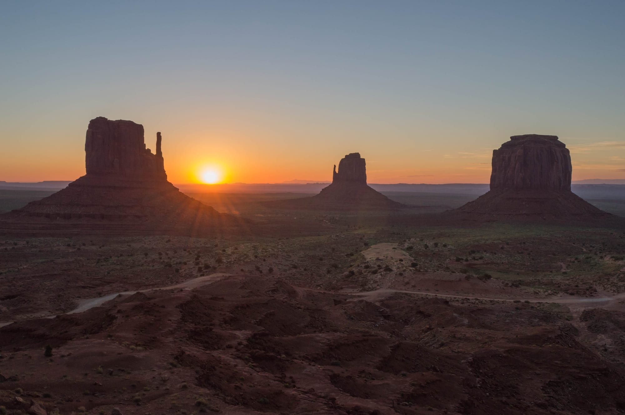
The sun rising between two dark sandstone buttes, with a third flat-topped butte on the right above a red desert floor

The Southwest, United States

Monument Valley

Sunrise behind West Mitten Butte, East Mitten Butte and Merrick Butte in Monument Valley Navajo Tribal Park. (Supercarwaar / Wikimedia Commons · CC BY-SA 4.0)

A scattered Navajo settlement on the Arizona–Utah line, spread among the red sandstone buttes of Monument Valley. The valley is sacred to the Navajo; a trading post, Hollywood westerns and a Navajo tribal park made its buttes an enduring image of the American West. Today a 17-mile dirt road runs between the buttes, and Navajo guides lead tours into the areas beyond it.

Neighbourhoods

  • The tribal park and visitor centre
    • First-time visitors
    • Viewpoints

    The Navajo Nation's park near the Arizona–Utah line, with a visitor centre, a campground and the classic view over the Mittens and Merrick Butte. The dirt loop road into the valley starts here, and Navajo guides run tours from the car park.

    Open in Maps
  • Goulding's and Oljato
    • Historic trading post
    • Quiet and residential

    The cluster of homes, a church, a campground and visitor services on the Utah side of the line, a few miles west of the park, below a sandstone mesa. It grew around a trading post founded in the 1920s, and the road continues to the old Oljato trading post.

    Open in Maps
  • Kayenta
    • Shops and services
    • Local life

    A Navajo town about 20 miles south, on the road towards Flagstaff, with supermarkets, petrol stations and cafés. Many visitors to the valley stay here.

    Open in Maps
  • Mexican Hat
    • River views
    • Road-trip stop

    A tiny settlement on the San Juan River about 20 miles north in Utah, named after a sombrero-shaped rock nearby. It sits at the start of the routes to the Valley of the Gods and Goosenecks State Park.

    Open in Maps

Things to do

The valley

  • Monument Valley Navajo Tribal Parkpark

    The Navajo Nation's park protecting the valley's buttes and mesas, with an unpaved loop road of about 17 miles open to private cars and backcountry areas that can be visited only with a Navajo guide.

    Open in Maps
  • West and East Mitten Butteslandmark

    The two buttes whose thin rock spires make them look like a pair of mittens, the valley's most famous view, seen straight on from the visitor centre.

    Open in Maps
  • Merrick Buttelandmark

    The broad, flat-topped butte beside the Mittens, named after a prospector who died in the area in the 19th century.

    Open in Maps
  • Hunts Mesaviewpoint

    A high mesa on the south-eastern edge of the valley, reached only with a Navajo guide, known for its panoramic views over the buttes.

    Open in Maps
  • Oljato Trading Postlandmark

    A trading post founded in 1906 on the western edge of Oljato–Monument Valley, whose present building dates from 1921, with areas set aside for trading wool and lambs.

    Open in Maps

Short trips from the village

  • Valley of the Godspark

    A quieter valley of sandstone towers near Mexican Hat in Utah, toured on a 17-mile gravel road that winds around the formations.

    Open in Maps
  • Goosenecks State Parkviewpoint

    A Utah state park on the rim of the deep, tightly winding meanders of the San Juan River, about 1,000 feet below.

    Open in Maps
  • Agathla Peaklandmark

    The dark volcanic neck that rises beside the highway between Kayenta and the valley, sacred in Navajo tradition.

    Open in Maps
  • Navajo National Monumentpark

    Cliff dwellings of the Ancestral Puebloans, including Betatakin, in the canyons west of Kayenta, seen from rim trails or on ranger-led hikes.

    Open in Maps
  • Four Corners Monumentlandmark

    The marker where Arizona, Utah, Colorado and New Mexico meet, maintained by the Navajo Nation as a tribal park.

    Open in Maps

Eat and drink

Long-standing places and food districts in Monument Valley. Hours, ratings and directions come from your maps app, always current.

Navajo food

  • Frybread stands in the tribal parkneighborhood

    Navajo families sell frybread and Navajo tacos from stands and stalls along the valley loop and near the viewpoints.

    Open in Maps
  • Kayentaneighborhood

    The nearest town with a choice of places to eat, from fast food to cafés serving Navajo tacos, mutton stew and American breakfasts.

    Open in Maps
  • Oljato–Monument Valley, Utah sideneighborhood

    The small cluster of visitor services on the Utah side, with the area's main grocery store and a petrol station.

    Open in Maps

Experience Monument Valley

History

People have lived around Monument Valley for thousands of years. Ancestral Puebloans lived in the region, leaving cliff dwellings such as those at Navajo National Monument to the south-west, and the valley later became Navajo land; in Navajo it is called Tsé Biiʼ Ndzisgaii, the "valley of the rocks". The region remained remote after the United States took it from Mexico. In 1864 most of the Navajo were forced on the Long Walk to imprisonment at Bosque Redondo, and the treaty of 1868 established the reservation to which they returned. Prospectors searching for silver came in the late 19th century; Merrick Butte is named after one of them, the silver miner Jack Merrick, who was killed in the area in 1880.

Trading posts became the meeting point of Navajo and outside life. Harry Goulding bought land here in 1921, and in 1928 he built a trading post on the Utah side that was also his family's home. During the Great Depression, when the director John Ford was looking for a location for Stagecoach, Goulding sent him photographs of the valley, and Ford filmed it here; it was released in 1939. Ford returned for westerns such as My Darling Clementine, Fort Apache and The Searchers, and the buttes became the image of the American West.

From the 1940s uranium was mined in and around the valley, providing work but leaving a legacy of illness and contamination that the Navajo Nation still deals with. The Navajo Nation later established Monument Valley Navajo Tribal Park, its equivalent of a national park. Tourism grew steadily, and the valley has come to define how many people imagine the American West.

Culture & Customs

Monument Valley is part of the Navajo Nation, the largest reservation in the United States, and Diné language, clan relationships and traditions shape daily life. Many families still keep sheep and goats, weave rugs on upright looms and live in homes alongside a hogan, the traditional Navajo dwelling, which is also used for ceremonies. The buttes and mesas carry names and meanings in Navajo tradition, and certain places are sacred.

Navajo guides lead visitors into the restricted areas of the park, telling stories about the formations, showing rock art and, sometimes, demonstrating weaving or singing. Jewellery, pottery, sand paintings and woven goods are sold at stalls throughout the valley, often directly by their makers. The valley's role in film is part of local identity too: after John Ford's westerns, many later films and advertisements were made here.

Visitors are guests on Navajo land. Courtesy means keeping to permitted areas, asking before taking photographs of people, speaking quietly near homes, and accepting that some places and ceremonies are not open to outsiders.

Daily Life

The population around the valley is small, mostly Navajo families spread across homesteads, small clusters of houses and the settlements at Oljato and around Goulding's. Distances are long: many people drive to Kayenta or further for groceries, health care and work, and roads are unpaved in many places.

Jobs are scarce. Tourism — guiding, crafts, food stands, lodging and park work — is the most important employer, along with schools, the clinic and the tribal government. Many young people leave for work in cities and return for family and ceremonies. Some homes across the Navajo Nation still lack mains electricity.

The day follows the land and the weather: livestock to tend, wood and water to fetch, and, for those in tourism, early starts for sunrise tours and long days in the heat. Winters are quiet, and summers bring tour buses and visitors from around the world. Health care access, water, the legacy of uranium mining and keeping the Navajo language alive among the young are recurring concerns.

Food

Navajo food is the local cuisine. Frybread — dough fried until puffy and golden — is eaten plain, with honey or powdered sugar, or as a Navajo taco, topped with beans, ground beef, lettuce, cheese, tomato and chile. Mutton, often boiled or made into stew, is a staple, eaten with frybread or tortillas. Frybread itself has become a symbol of perseverance for the Navajo and other Native peoples, because of its history.

Corn has deep roots in Navajo cooking and, with mutton, was long one of the principal foods, prepared in many ways for family meals and gatherings. Navajo tea, made from a wild plant called greenthread, is a traditional drink.

Restaurants are few, and most visitors eat at the lodges near the park, at stands along the valley loop or in Kayenta, which has the widest choice. Supermarkets in Kayenta are the place to stock up on food and water before heading into the valley.

Planning tools

Budget

There are few places to stay around the valley, so rooms are expensive for what they offer and fill early in summer; Kayenta and Mexican Hat are usually cheaper. Food is simple and moderately priced. The tribal park charges an entry fee, guided tours into restricted areas cost extra, and a car is essential for getting here.

Daily Budget Midrange
USD 220–400 (room near the park, sit-down meals, a guided Navajo tour, park entry, hire car)
Daily Budget Shoestring
USD 100–170 (campsite or basic motel in Kayenta or Mexican Hat, frybread and diner meals, own car)

National park passes are not valid on the Navajo Nation: the tribal park has its own entry fee.

Best Time to Visit

Spring and autumn bring the most comfortable temperatures. Summer is hot, with afternoon thunderstorms in July and August, and is the busiest season. Winter is cold and quiet, and snow on the red rock, most likely in December or January, is a much-photographed sight. Sunrise and sunset light the buttes in deep reds at any time of year.

Suggested Number of Days

One night is enough to see the valley at sunset and sunrise and drive or tour the loop. More time allows a longer guided trip into restricted areas and visits to the canyons, cliff dwellings and viewpoints of the surrounding Navajo and Utah lands.

First Visit
1–2 days
With Surroundings
3–4 days

Transportation

A car is essential: there is no public transport for visitors. The valley loop is unpaved, rough and dusty, with deep holes in places, and high-clearance vehicles are recommended. Navajo-owned tour companies run open-truck and jeep tours from the visitor centre, and these are the only way into areas off the main loop.

Watch for sheep, horses and cattle on the highways, especially at night, and fill the tank in Kayenta or Mexican Hat — distances between petrol stations are long.

Airport & Station Connections

The valley lies on US Highway 163 between Kayenta, Arizona, and Mexican Hat, Utah. Flagstaff and the Grand Canyon are reached by US 160 through Kayenta. The nearest large airports are in Phoenix and Las Vegas, about five and six and a half hours away by road; most people arrive on a road trip through the Four Corners region.

Walkability

The settlement is spread over many miles, and walking is limited to the area around the visitor centre and lodgings. The only self-guided walk in the park is the Wildcat Trail around West Mitten Butte, about three miles on soft sand; elsewhere hiking is allowed only with a Navajo guide.

Safety

Crime against visitors is rare. The real risks are heat, sun and dehydration in summer, deep sand and flash floods after storms, livestock and fatigue on long, unlit roads at night, and the remoteness of the area, where mobile coverage and medical help can be far away.

Carry plenty of water, stay on the marked roads and trail, and do not drive across flooded washes. Check current official travel advice before travelling.

Climate

A high, dry desert climate at about 5,500 feet. Days are sunny for most of the year, nights cool quickly, and wind and dust are common in spring. A monsoon brings thunderstorms in late summer.

Summer
hot days in the upper 80s to low 90s °F, cooler nights, and afternoon thunderstorms in July and August
Winter
days usually above freezing, nights below freezing and sometimes below 0 °F, with some snow

Local Customs

The valley is home to Navajo (Diné) families, and the land, homes and livestock are private. Visitors keep to public roads and areas, and ask before photographing people, homes or ceremonies. Unlike the rest of Arizona, the Navajo Nation changes its clocks in summer, so times here match Utah. Tipping guides is customary.

Alcohol is banned on the Navajo Nation, including in the tribal park and lodgings. Do not climb the rock formations or remove rocks, plants or artefacts.

Common Payment Methods

The currency is the US dollar. Cards are accepted at the visitor centre, lodgings and larger shops, but cash is needed at many craft stalls and food stands, and ATMs are few — Kayenta has the most reliable choice.