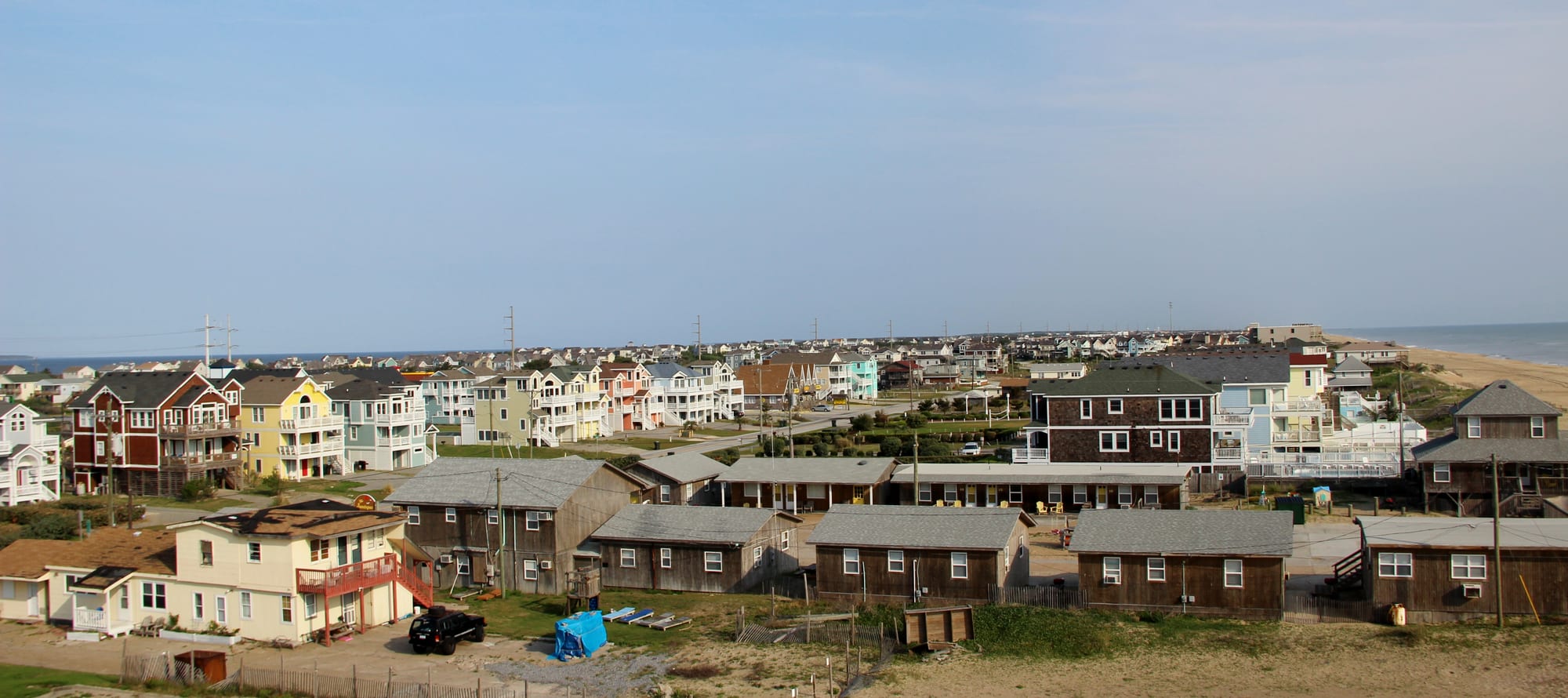
Rows of pastel multi-storey beach houses and low wooden cabins in Nags Head, with the Atlantic beach on the right

The South, United States

Nags Head

Beach houses along the oceanfront in Nags Head, North Carolina. (lns1122 / Wikimedia Commons · CC BY 2.0)

A beach town on Bodie Island in North Carolina's Outer Banks, with the Atlantic on one side and Roanoke Sound on the other. It became known as a resort around 1830, and weathered cottages from its early decades as a seaside resort still stand on the beach road. Today it is a long strip of rental houses, fishing piers and seafood restaurants beside the tallest sand dunes on the East Coast.

Neighbourhoods

  • The Beach Road oceanfront
    • Beaches
    • First-time visitors
    • Fishing piers

    Virginia Dare Trail, the two-lane road that runs the length of the town a block from the sand, lined with rental houses, motels, beach-access boardwalks and the fishing piers. Most visitors stay here, and the ocean is a short walk from anywhere on it.

    Open in Maps
  • Old Nags Head Cottage Row
    • Historic district
    • Quiet and residential

    A stretch of the beach road where wood-shingled cottages from the late 19th and early 20th centuries still face the ocean, listed together on the National Register of Historic Places. Locals call the brown, weathered houses the Unpainted Aristocracy.

    Open in Maps
  • The soundside and Jockey's Ridge
    • Families
    • Sunsets
    • Watersports

    The west side of the town along Roanoke Sound, where the water is shallow and calm, the sunsets are watched from the dunes, and the hang-gliding school, the kayak and sailboard launches and several waterfront restaurants are found. The great dune of Jockey's Ridge rises between the bypass and the sound.

    Open in Maps
  • Whalebone Junction and South Nags Head
    • Quiet and residential
    • Beaches

    The southern end of the town, where the bypass, the beach road and the causeway to Roanoke Island meet. Beyond the junction the houses thin out along the beach road into South Nags Head, a quieter residential stretch that ends at the boundary of Cape Hatteras National Seashore.

    Open in Maps

Things to do

Beaches and piers

  • Jennette's Pierlandmark

    The oldest pier on the Outer Banks, rebuilt in concrete after damage in Hurricane Isabel and reopened in 2011, now run by the North Carolina Aquariums, with education programmes and fishing from the end.

    Open in Maps
  • Nags Head Fishing Pierlandmark

    A fishing pier on the beach road, one of three piers along the town's shore that are popular for fishing.

    Open in Maps
  • Coquina Beachbeach

    An undeveloped beach in Cape Hatteras National Seashore, about 8 miles south of Nags Head off NC 12, across from Bodie Island Lighthouse.

    Open in Maps

Dunes, woods and the sound

  • Jockey's Ridge State Parkpark

    The tallest natural sand dune system on the eastern seaboard of the United States, saved from development in the 1970s, used for hang gliding, kite flying and watching the sunset over Roanoke Sound.

    Open in Maps
  • Nags Head Woods Ecological Preservepark

    A wooded preserve of 1,092 acres north of Jockey's Ridge and east of Roanoke Sound, designated a National Natural Landmark in 1974.

    Open in Maps

Short trips from the town

  • Wright Brothers National Memoriallandmark

    The granite monument and reconstructed camp buildings at Kill Devil Hills, a few miles north, where the Wright brothers made the first powered flights in December 1903.

    Open in Maps
  • Bodie Island Lighthouselandmark

    A lighthouse of 1872 south of the town, the third to stand near this spot, which the public can climb for a fee since its restoration was completed in 2013.

    Open in Maps
  • Fort Raleigh National Historic Sitelandmark

    On Roanoke Island across the causeway, the site of the English colony of the 1580s whose settlers' fate remains a mystery, with a visitor centre museum on the colonies and the island's history.

    Open in Maps
  • The Elizabethan Gardenspark

    Period-style gardens on Roanoke Island, created as a memorial to the first colonists and managed by the Garden Club of North Carolina.

    Open in Maps
  • Roanoke Island Festival Parkattraction

    A state history park at Manteo with a sailing replica of a 16th-century ship, a recreated settlement and a museum of the island.

    Open in Maps
  • North Carolina Aquarium on Roanoke Islandattraction

    One of the state's three public aquariums, with live animal encounters, feeding programmes and dive shows.

    Open in Maps
  • Pea Island National Wildlife Refugepark

    A refuge on Pea Island, a barrier island to the south, where migrating birds gather in the ponds and marshes, with ocean beach and dunes.

    Open in Maps
  • Cape Hatteras Lighthouselandmark

    The tallest lighthouse in the United States, a brick tower at Buxton moved inland from the eroding shore in 1999, about 47 miles south in a straight line along NC 12.

    Open in Maps
  • Currituck Beach Lighthouselandmark

    An unpainted red-brick lighthouse of 1875 at Corolla, north of the town, near the beaches where wild horses roam.

    Open in Maps

Seasonal events

  • The Lost Colonysummer

    An outdoor drama about the Roanoke colonists performed at the Waterside Theatre on Roanoke Island since 1937, apart from a break during the Second World War, and one of the longest-running historical outdoor dramas in the United States.

  • First Flight anniversarymid-December

    A commemoration of the Wright brothers' flights of 17 December 1903 at the memorial in Kill Devil Hills.

Eat and drink

Long-standing places and food districts in Nags Head. Hours, ratings and directions come from your maps app, always current.

Nags Head classics

  • Beach Road seafood restaurantsneighborhood

    The long-standing family restaurants along the beach road serve the Outer Banks staples — fried and broiled flounder, shrimp, soft-shell crabs in spring, hushpuppies and clear Hatteras-style clam chowder.

    Open in Maps
  • Whalebone Junctionneighborhood

    The cluster of diners, seafood houses and bars around the junction at the south end of the town, where the main roads of the Banks meet.

    Open in Maps

The soundside and the causeway

  • Soundside restaurants on the causewayneighborhood

    Waterfront seafood restaurants and fish markets along the causeway to Roanoke Island, where tables look west over the water at sunset.

    Open in Maps
  • Duck Donutscafe

    A chain of made-to-order doughnut shops that began in the village of Duck up the Banks in 2006 and now has more than 120 locations across the United States.

    Open in Maps

Experience Nags Head

History

The name appears on early maps, and nobody is sure where it came from — one of the places called Nag's Head on the English coast, or the legend that islanders tied a lantern to a horse and walked it along the dunes so that ships would mistake it for a safe anchorage and wreck on the shoals. The last story is probably invented, but wrecking and salvage were real parts of life on this coast, which lies beside the shifting shoals that sailors call the Graveyard of the Atlantic.

Nags Head became known as a resort around 1830, when the only way to reach the island was by boat. Growth quickened in 1855, when Dr W. G. Pool bought 50 acres of oceanfront land, divided it into plots and sold them to friends. The wood-shingled cottages built along the ocean in the late 19th and early 20th centuries survive as the Nags Head Beach Cottages Historic District, listed on the National Register of Historic Places in 1977 and nicknamed the Unpainted Aristocracy.

The Wright Memorial Bridge of 1930 brought cars to the northern Banks. Nags Head was incorporated as a town in 1961. In 1973 bulldozing began on the sound side of the great dune of Jockey's Ridge; a local resident, Carolista Baum, raised the alarm, and the dune became a state park two years later. Since then the town's story has been one of growth in rental houses, repeated hurricanes and nor'easters, and a long effort to hold the beach in place with sand pumped from offshore.

Culture & Customs

Nags Head's culture is the culture of the Outer Banks: wind, water and the sea. The steady winds that drew the Wright brothers to the dunes a few miles north still bring hang-gliders to Jockey's Ridge, where the world's largest hang-gliding school teaches beginners on the sand slopes, and kiteboarders and windsurfers to the shallow sound. Surfing has a long local following, and the piers are social places where people fish at dawn and gossip through the afternoon. Charter boats leave the nearby marinas for the Gulf Stream, and a big tuna or marlin on the dock is still an event.

History is performed here. Roanoke Island across the causeway has staged The Lost Colony in summer since 1937, with a break during the Second World War, an outdoor drama about the English settlers who vanished in the 1580s. The Wright brothers' first flight is marked each December at Kill Devil Hills, and the Elizabethan and colonial past is woven through place names, from Virginia Dare Trail to Manteo.

The year-round community is small, and its people — bankers, in the old local word — are known for a dry independence formed by isolation, storms and a tourist economy that empties out each autumn. Church, the volunteer fire company and the school in Manteo bind it together. Manners are easy and unhurried: a wave from the car, a chat at the fish market, no hurry at the restaurant. Visitors are welcomed as the livelihood, but asked to respect the dunes, the turtle nests and the right of way at the boat ramp.

Daily Life

About 3,200 people live in Nags Head all year, in a town that stretches for miles along the island and holds many times that number in July. Most of its houses are holiday rentals or second homes, and the economy runs on them: cleaning and maintenance crews, property managers, restaurants, surf shops, fishing charters and the building trade. Many workers commute from the mainland or from Manteo, where housing is cheaper, and the shortage of affordable homes for year-round residents is a constant subject of local politics.

The day follows the sun. In summer the beach fills by mid-morning, the piers and the sound take the late afternoon, and the restaurants are busy from early evening. The change-over day for rental weeks, usually Saturday or Sunday, brings queues across the bridge and an exodus the other way. In the off-season the town turns inward: shops close for the winter, locals walk the empty beach with dogs, and the fishing community has the water to itself.

The permanent worries are erosion and water. The ocean has been taking the beach for generations, and the town has made projects to manage the erosion a priority. Storms close the beach road, overwash the dunes and occasionally take houses; sea-level rise and the flooding of the only road south are discussed as questions of decades, not centuries. Dare County governs much of local life, and the town's older children go to middle and high school in Manteo on Roanoke Island.

Food

Seafood is the point. The sounds and the ocean supply blue crabs, shrimp, flounder, sea trout, spot, bluefish and, from the Gulf Stream, yellowfin tuna and mahi-mahi; oysters are a winter food and soft-shell crabs a treat of late spring, when the blue crabs moult and are fried whole and eaten in a sandwich. The classic plate is a fried or broiled seafood platter with coleslaw and hushpuppies, the fried balls of cornmeal batter served everywhere in coastal North Carolina. Clam chowder in the Hatteras style is clear, made with clams, potatoes, onion and bacon and no cream or tomato, and is a genuine local dish.

Fish markets on the causeway and the beach road sell the day's catch to the thousands of rental houses with kitchens, and cooking at home is as much a part of a Nags Head week as eating out. Eastern North Carolina pork barbecue — chopped whole hog with a thin vinegar-and-pepper sauce — reaches the Banks from the mainland, as do sweet tea and the biscuits and grits of a Southern breakfast.

The town's restaurants range from decades-old family seafood houses and diners to newer places serving tuna and fish tacos, and most of them close or cut their hours in winter. Beer and wine are sold in supermarkets; spirits only in the state-run ABC stores, as across North Carolina. Doughnuts from the chain that began up the Banks in Duck, and ice cream on the beach road after dark, round out a summer day.

Planning tools

Budget

Nags Head is a rental-house town, and the cost of a week depends almost entirely on the house and the season. Weekly rentals and motel rooms are at their most expensive from mid-June to mid-August; the same house costs a fraction of that in April or October. Beaches, the dunes and the sound are free, and eating in is normal because most houses have full kitchens.

Daily Budget Midrange
USD 220–400 (motel room or a share of a rental house, seafood dinners, a pier or lighthouse ticket, rental car and fuel)
Daily Budget Shoestring
USD 100–170 (campsite or shared off-season rental, groceries and fish-market suppers, a day at the beach)

Rentals usually run Saturday to Saturday or Sunday to Sunday in summer and are booked months ahead; a fortnight either side of the peak season is much cheaper and the water is still warm into October.

Best Time to Visit

Late May to September for swimming and the full summer scene, with July and August the busiest and most expensive. September and early October are many regulars' favourite weeks — warm water, thinner crowds, the autumn fishing run — though it is also the heart of the hurricane season. Spring is windy and good for kites and hang gliding. Winter is quiet and grey, with many businesses closed, but the beaches are empty and rates are low.

Suggested Number of Days

A long weekend covers the town, the dunes and the nearby sights. Most visitors come for a full week, which is how rental houses are let in summer; that length allows for beach days as well as Roanoke Island and a drive down the national seashore to Hatteras.

First Visit
3–4 days
With Surroundings
7 days

Transportation

There is no public transport on the Outer Banks, and nearly everyone arrives and gets around by car. Two roads run the length of the town: the beach road (NC 12, Virginia Dare Trail) and the faster four-lane bypass (US 158). Cycling is popular on the beach road and the multi-use path beside the bypass, and bike hire is easy to find. Taxis and ride-hailing exist but are thin on the ground outside summer.

Driving on the beach is tightly restricted: check the town's and the national seashore's rules first, as off-road vehicle access is closed on many stretches while birds are nesting.

Airport & Station Connections

The nearest large airport is Norfolk, Virginia, to the north; Raleigh–Durham, to the west, is a considerably longer drive. From either, the road crosses to the Banks on the Wright Memorial Bridge over Currituck Sound at Kitty Hawk, then runs south through Kill Devil Hills to Nags Head. Summer Saturdays bring long queues on the bridge as the rental weeks change over.

Walkability

Within a block or two of the beach road the town is pleasant on foot — sand, pier, restaurants and shops — but the town is long and only a few blocks wide, so walking between its parts means a long, flat trudge beside traffic. The bypass has no real footway and is best crossed at traffic lights. Boardwalk accesses to the beach are frequent, and the soundside paths and Nags Head Woods trails are easy.

Safety

Crime is low and the risks are natural ones. Rip currents cause drownings on the Outer Banks every summer, and the surf can be rough even on sunny days; lifeguards sit on some beaches only in season. Hurricanes and nor'easters threaten from late summer into autumn, and the beach road and NC 12 flood in storms. Sun, heat and ticks in the woods are the everyday concerns.

Swim near a lifeguard, learn how to escape a rip current by swimming parallel to the shore, and follow Dare County's evacuation orders without delay when a storm approaches. Check current official travel advice before travelling.

Climate

A maritime climate moderated by the sea and the warm Gulf Stream offshore, with constant wind. Rain falls through the year, and tropical storms are a possibility from June to November, peaking in September.

Summer
Hot and humid, with a cooling afternoon sea breeze on most days, though in spells of extreme heat the heat index can reach 100 °F or more; afternoon thunderstorms are common.
Winter
Cool and windy, with occasional cold spells when the wind chill drops below 10 °F; nor'easters, most frequent in February, bring rain, wind and high tides, and snow is rare and light.

Local Customs

This is a relaxed beach town where flip-flops and shorts are fine almost everywhere, and the full-time community of a few thousand is outnumbered many times over in summer. Fishing, surfing and the weather are the common conversation, and locals from the islands have long called themselves bankers.

Tip 18–20 percent in restaurants and a few dollars to anyone who carries bags or parks a car. Beer and wine are sold in shops and spirits only in state ABC stores. Keep off the dunes except on marked paths, give sea turtle nests and nesting birds a wide berth, and never feed or approach the wild horses further north.

Common Payment Methods

The US dollar. Cards are accepted almost everywhere, including at the piers and most fish markets, and contactless payment is common. ATMs are in banks, supermarkets and petrol stations along the bypass. A little cash is useful for roadside produce stands and tips.