History · Peru
Why are there giant drawings in the Nazca desert?
The Nazca people scraped them into the desert floor some 2,000 years ago, probably for religious ceremonies, perhaps rituals to bring water to a parched land.
By Globeway Editorial · 13 October 2026
The short answer
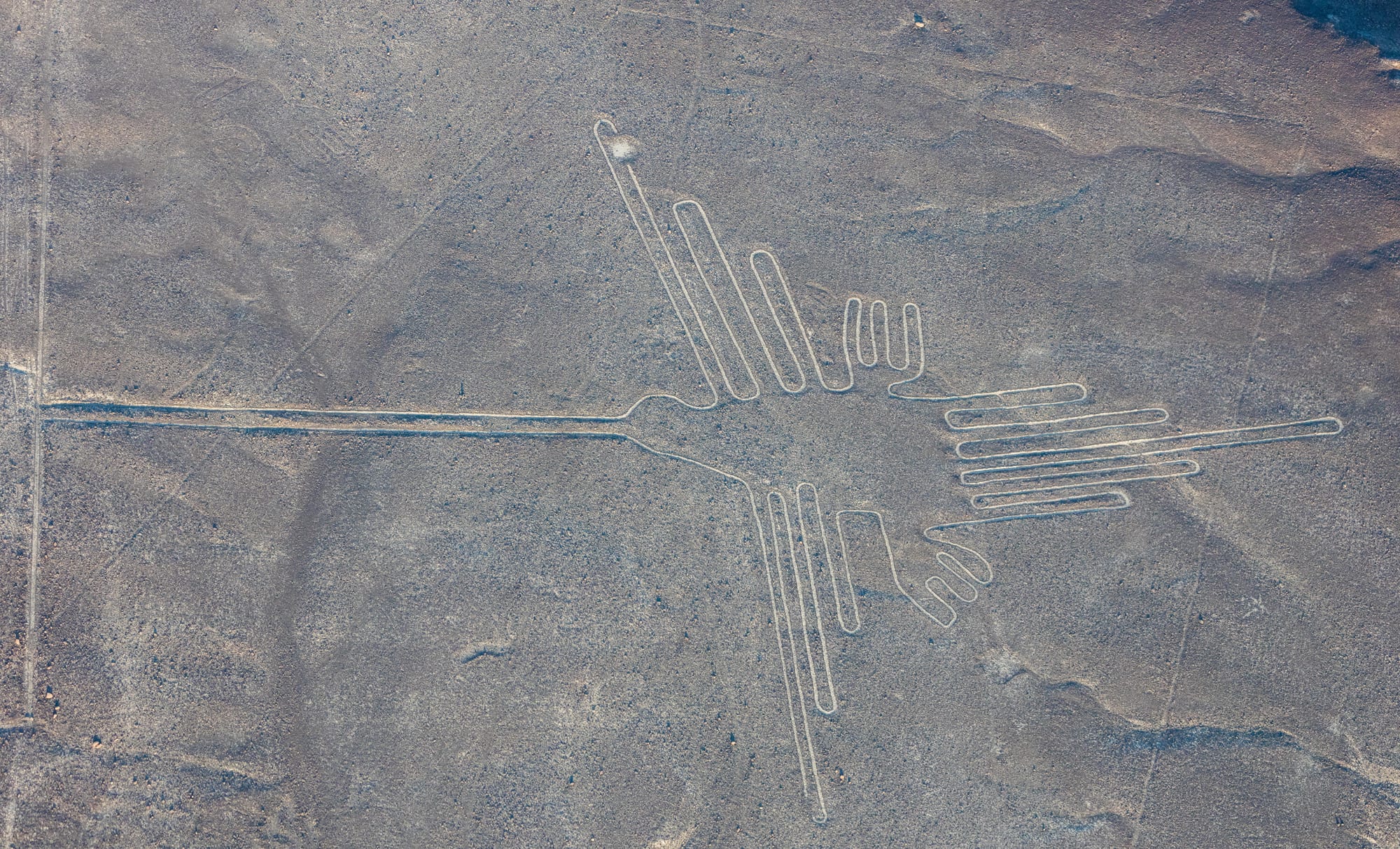
The drawings, known as the Nazca Lines, were made by the people who lived in this part of southern Peru between about 500 BC and AD 500, first in the time of the Paracas culture and then, above all, by the Nazca. They created them by clearing away the dark pebbles that cover the desert to expose the pale ground beneath. Some are straight lines and geometric shapes; more than 70 are animal figures, among them a hummingbird, a monkey, a spider and a condor.
No one left a written explanation, so the purpose has to be reconstructed, and scholars still disagree. Most agree that the lines had a religious meaning. One leading idea is that they were tied to water, the scarcest thing in this arid land: sacred paths walked in ceremonies to ask the gods for water and fertile fields, linked to pilgrimage centres such as Cahuachi. The once popular theory of a giant astronomical calendar has found little support, and the claim that aliens made them has no scientific basis.
Drawing on the desert floor
The technique was simple. The surface of the Nazca Desert is covered in reddish-brown pebbles coated with iron oxide. Remove them, and a yellow-grey, lime-rich subsoil appears, contrasting sharply with the ground around it. The trenches are typically only 10 to 15 centimetres deep. More than half of the lines are a little over 33 centimetres wide, though some reach 1.8 metres. Each animal figure is usually drawn as a single continuous line.
The scale is not. Straight lines run across a plateau that stretches more than 80 kilometres between the towns of Nazca and Palpa, about 400 kilometres south of Lima, and their combined length exceeds 1,300 kilometres. The largest figures are about 370 metres long. The condor measures 134 metres, the hummingbird 93 metres.
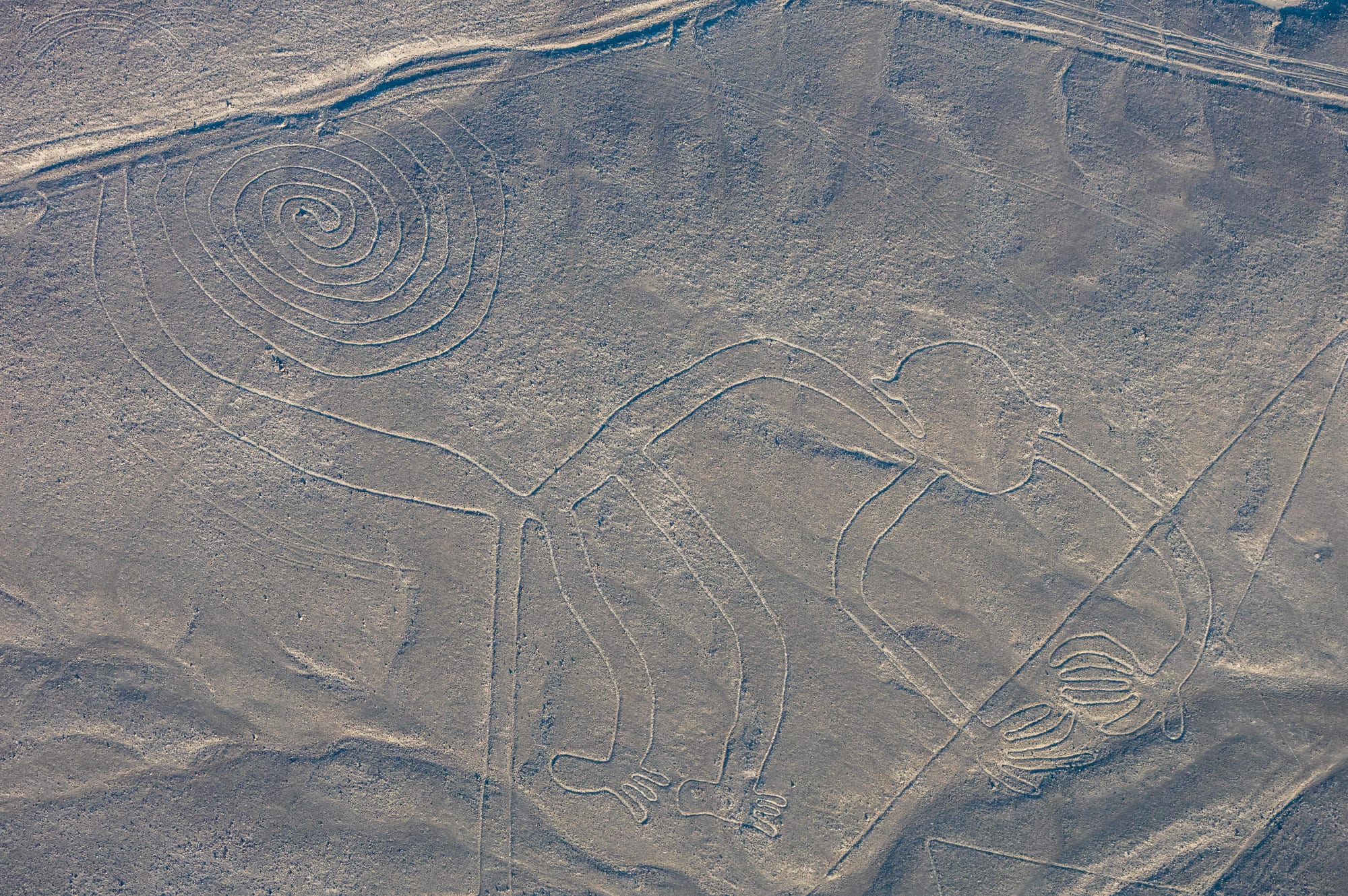
The monkey measures 93 by 58 metres. Like most of the figures, it is best appreciated from the air, though many can also be seen from the foothills around the plain.
Making figures this large without seeing them from above sounds impossible, but it is not. Archaeologists have found wooden stakes at the ends of some lines, suggesting the makers laid out their designs with simple surveying methods, and one stake provided a radiocarbon date for the complex. The investigator Joe Nickell later recreated the figures using only tools the Nazca had, showing that a small, well-organised team could reproduce even the largest in days, without any view from the air.
That the lines survive at all is down to the climate. The plateau is dry, windless and stable, and morning mist helps the exposed lime harden into a crust that protects the lines from the wind.
The people of the plain
The Nazca culture flourished from about 100 BC to AD 800 in the river valleys of this arid coast. Its people are known for vividly painted pottery and fine textiles, and for a feat of engineering as remarkable as the lines: puquios, underground aqueducts that supply water for irrigation and homes. Forty-three of them in the Nazca region were still in use in the early twenty-first century, although their date is disputed; some archaeologists think construction began around AD 500.
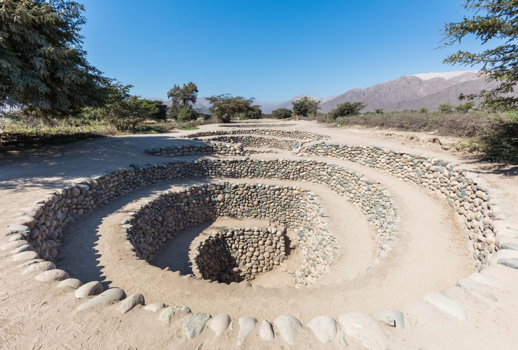
In a land with almost no rain, the people of Nazca went to great lengths to find and channel water.
Their great ceremonial centre was Cahuachi, occupied from about AD 1 to 500, a complex of more than 40 mounds topped with adobe buildings. It housed few permanent residents. Archaeologists believe it was a pilgrimage centre whose population swelled for major ceremonies, and the remains found there, including large amounts of fine pottery, point to rituals and feasting connected with agriculture, water and fertility. From about AD 500 the culture declined, possibly after an El Niño brought destructive floods, and by 750 it had collapsed.
A calendar in the sand?
The first scholar to study the lines in depth was the American historian Paul Kosok. In Peru in 1940 and 1941 to study ancient irrigation, he flew over the plain, recognised a bird, and noticed how lines converged on the horizon at the time of the southern winter solstice. With the German mathematician Maria Reiche, he proposed that the lines were an observatory, marking the points on the horizon where the sun and other heavenly bodies rose or set on important dates. Reiche later argued that some figures represented constellations.
The idea was attractive, but it did not survive testing. In 1990 the archaeoastronomers Gerald Hawkins and Anthony Aveni concluded that the evidence was insufficient to support it. Recent work at Pampa de Atarco, south of the main plain, has found radial centres of lines aligned on the winter solstice and the equinox sunset, so the calendar may have been one theme among several rather than the main purpose.
Water, gods and pilgrims
In 1985 the archaeologist Johan Reinhard brought together archaeological, historical and ethnographic evidence that the worship of mountains and water sources lay at the centre of Nazca religion. He argued that the lines were sacred paths leading to places where water deities were worshipped, and that the animal figures were symbols meant to invoke their help in sending water for crops. Another researcher, David Johnson, has argued that some lines follow underground water sources tapped by the puquios.
Later studies have tied the lines more closely to movement and ceremony. Nicola Masini and Giuseppe Orefici found geoglyphs near Cahuachi grouped by function, including meandering ceremonial lines, and concluded that they were the settings for events in the farming calendar that brought groups of pilgrims together. A 2024 study of the figures suggested that the large figures drawn in outline, mostly of wild animals, were planned public architecture for ceremonies performed during pilgrimages, while smaller figures showing humans and domesticated animals were meant to be seen from walking trails.
The most famous rival theory came from Erich von Däniken, whose 1968 book Chariots of the Gods? claimed the lines were landing strips for visitors from other worlds. Maria Reiche called the idea absurd, and Nickell's experiments showed that nothing beyond human hands and careful planning was needed.
Guarding the lines today
Reiche made the lines her life's work. She lived nearby, paid for guards, lobbied officials after the Pan-American Highway was cut through one figure, and sponsored a viewing tower beside the road so that visitors could see the lines without walking on them. They became a UNESCO World Heritage Site in 1994, and she died in 1998.
The lines remain fragile. Trenches this shallow cannot withstand heavy rain, and human damage has added up: squatters moved onto the land in 2012, activists from Greenpeace damaged the area around a figure while setting up a banner in 2014, and a lorry driver left tyre marks across three geoglyphs in 2018. In 2025 Peru's Ministry of Culture ordered a large cut in the protected area, then reversed the decision shortly afterwards amid concern over informal mining. The figures are best seen from the air, at around 500 metres, but many are also visible from the viewing tower and the surrounding foothills.