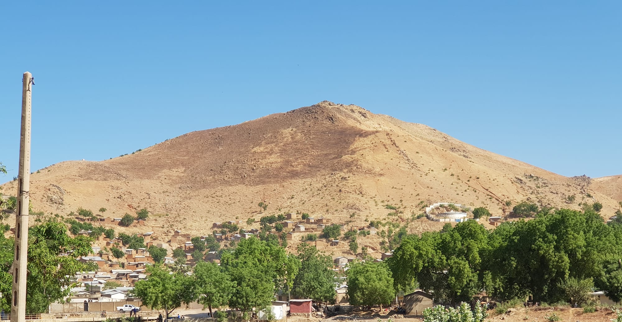
A bare brown hill rising above a quarter of low brick houses and green trees under a hard blue sky

Maroua, Waza & the North, Cameroon

Maroua

A rocky hill rising above the houses and trees of Maroua on the Diamaré plain. (KENMEUGNE KAMTOH Kévin / Wikimedia Commons · CC BY-SA 4.0)

The capital of Cameroon's Far North Region, spread along the sandy bed of the Kaliao river on the Diamaré plain below the Mandara mountains. A Fulani lamidate town turned regional capital, it is known for leatherwork and craft markets, and it has lived since the mid-2010s with the Boko Haram insurgency in the countryside around it. This page is written to explain the city, not to encourage travel.

Neighbourhoods

  • Domayo and the central markets
    • Markets
    • First-time visitors
    • Best for food

    The trading heart of the city, where the main market and the craft and leather sellers are concentrated, along with transport agencies and small eating houses. It is the busiest and noisiest part of Maroua, and the place most visitors see first.

    Open in Maps
  • Founangué and the administrative quarter
    • Historic district
    • Quiet and residential

    The old Fulani quarter around the lamido's palace and the main mosque, next to the governor's offices and regional services. Wide, tree-shaded streets, single-storey administrative buildings and compound walls give it a calmer feel than the market side.

    Open in Maps
  • Djarengol and Kakataré
    • Local life
    • Quiet and residential

    Residential quarters spreading out from the centre, built of mud brick and concrete around family compounds, with neighbourhood mosques, small shops and schools. Everyday life here runs to the rhythm of the morning market and the evening tea stalls.

    Open in Maps
  • The Kaliao riverbanks
    • Walks
    • Local life

    The broad sandy bed of the Kaliao, dry for much of the year, divides the city and is crossed by several bridges. Its banks are used for washing, market gardening and football, and neem and mango trees line the roads beside it.

    Open in Maps
  • Along the university road
    • Students
    • Quiet and residential

    The quarters towards the campuses of the University of Maroua, established in 2008, where student lodgings, print shops and cheap eating houses have grown up along the main road out of town.

    Open in Maps

Things to do

In the city

  • Maroua craft marketmarket

    The city's best-known market, where leatherworkers, weavers, dyers and potters sell sandals, bags, cushions, embroidered robes and calabashes in a quarter of small workshops and stalls.

    Open in Maps
  • The lamido's palacelandmark

    The compound of the Fulani ruler of Maroua, seat of a lamidate founded in the 19th century, where the lamido still holds court and appears with horsemen and drummers at the Muslim festivals.

    Open in Maps
  • University of Maroualandmark

    The region's public university, established in 2008, whose campuses and students have changed the character of the city's outskirts.

    Open in Maps

Landscapes around the city

  • Mandara Mountainsattraction

    A volcanic range running along the Nigerian border west of Maroua, terraced for millet and sorghum and dotted with stone-walled compounds of the Mafa, Mofu and Kapsiki peoples.

    Open in Maps
  • Rhumsikiviewpoint

    A Kapsiki village in the mountains west of the city, set among eroded volcanic plugs — the best-known landscape in northern Cameroon.

    Open in Maps
  • Mokoloattraction

    The main town of the Mandara mountains west of Maroua, a market centre for the mountain villages and the road junction for Rhumsiki.

    Open in Maps

Short trips from the city

  • Waza National Parkpark

    A floodplain savanna park north of Maroua, created as a reserve in 1934 and a UNESCO biosphere reserve since 1979, known for elephants, giraffes and dry-season birdlife, though poaching and insecurity have reduced its wildlife.

    Open in Maps
  • Maroua Salak Airporttransit hub

    The city's airport, about 15 kilometres to the south-west of Maroua, near the village of Salak.

    Open in Maps

Seasonal events

  • Eid al-Fitr and Eid al-Adhaafter Ramadan and about two months later

    The two great Muslim festivals fill the prayer grounds in the morning and bring processions of horsemen in embroidered robes and quilted armour to the lamido's palace.

  • Dry-season market daysNovember to February

    The cool months are the season when traders and mountain villagers come down to the city's markets in the greatest numbers, and when craft workshops are busiest.

Eat and drink

Long-standing places and food districts in Maroua. Hours, ratings and directions come from your maps app, always current.

Northern classics

  • Boule with saucerestaurant

    The staple of the north — a stiff paste of millet, sorghum or maize flour, called couscous in local French, eaten by hand with a sauce of okra, dried fish, sorrel or baobab leaf.

    Open in Maps
  • Kilichimarket

    Thin strips of beef coated in spiced groundnut paste and dried in the sun, a northern speciality sold in every market and taken home as a gift from the region.

    Open in Maps

Markets and street food

  • The central marketmarket

    Millet and sorghum, onions and dried fish from the Logone, peppers, groundnuts, dates and cloth, with cooked-food sellers at the gates.

    Open in Maps
  • Evening grills and tea stallsneighborhood

    Soya beef skewers over charcoal, grilled mutton, and small stalls serving very sweet tea and coffee are the centre of evening street life once the heat drops.

    Open in Maps

Experience Maroua

History

The Diamaré plain was settled long before the city took shape, by the Giziga and related peoples whose chiefdoms held the land around the rocky hills that rise from the flat country. Maroua itself grew at a crossing of the Kaliao river, where the plain meets the roads into the Mandara mountains, and its markets drew traders from the mountains and from the Lake Chad basin.

The decisive change came with the Fulani jihad of the early 19th century, which spread from Sokoto across the plains and founded the emirate of Adamawa. Fulani leaders established a lamidate at Maroua, displacing or subordinating the existing chiefdoms, and the town became one of a chain of lamidates that included Garoua, Ngaoundéré and Rey Bouba. Islam, Fulfulde and a courtly style of authority spread with them, while peoples who resisted withdrew into the mountains to the west.

Germany conquered the north at the turn of the 20th century and, like the French after 1916, governed through the lamidos rather than replacing them. Under French administration Maroua became an administrative centre; after independence it grew as the seat of government for the Far North, gaining schools, a hospital, an airport at Salak and, in 2008, a university. From around 2014 the Boko Haram insurgency spread from north-eastern Nigeria into the region, bringing attacks, a large military deployment and waves of displaced families into the city, and ending the tourist traffic that had passed through on the way to Waza and Rhumsiki.

Culture & Customs

Maroua is a Muslim, Fulfulde-speaking city with a courtly tradition. The lamido remains a figure of authority alongside the state administration, receiving visitors in his palace and appearing at the two Eids with horsemen in embroidered robes and quilted armour, accompanied by drummers and long trumpets. Pulaaku, the Fulani code of reserve, dignity and patience, shapes how people speak and behave in public.

Around the Fulani core the city is far more mixed than it first appears. Mafa, Mofu, Kapsiki, Podoko and other mountain peoples, Kotoko and Shuwa Arabs from the plains towards Lake Chad, Mbororo herders and southerners posted north for work all live here, and Christian churches stand among the mosques. Fulfulde serves as the common language of the market, with French for administration.

Craft is the city's signature. Maroua leather — sandals, bags, cushions, saddlery — is known across Cameroon, worked in small courtyard workshops and sold in the craft market, alongside embroidered robes, indigo-dyed cloth, woven mats, pottery and decorated calabashes. Music and dance belong to the calendar of weddings, naming ceremonies and festivals, and evenings are spent over glasses of very sweet tea at street stalls, a habit as much social as refreshing.

Daily Life

Maroua had about 200,000 residents at the 2005 census and is considerably larger now, swollen by people displaced from border villages as well as by ordinary migration from the countryside.

The city lives on trade, administration and crafts rather than industry. It is the marketplace for the Diamaré plain and the mountains, dealing in millet, sorghum, groundnuts, onions, cotton and cattle; the regional government, hospitals, schools and the university provide salaried work; and leatherwork, tailoring, dyeing and pottery employ many households. International aid agencies have had a substantial presence since the insurgency began, and camps to the west of the city shelter refugees who have crossed from Nigeria.

Days start before dawn while the air is cool. Markets are busiest in the early morning, work slows through the hot middle of the day, and life returns in the late afternoon, with grills, tea stalls and football on open ground. Motorcycle taxis swarm the main roads. Poverty is deeper here than in southern Cameroon, school enrolment lower, and the seasonal extremes — drought, flood, searing heat — shape household fortunes. Security checks, curfews and the presence of soldiers are a constant of the city's routine.

Food

Northern food is built on grain. Boule, called couscous in local French, is a stiff paste of millet, sorghum or maize flour rolled into a ball by hand and dipped into a sauce — okra thickened until it pulls, dried fish, sorrel, baobab leaf or a groundnut sauce. It is eaten at the midday and evening meals in most households.

Cattle make the difference between the north and the rest of Cameroon. Beef appears as kilichi, thin sheets of meat coated in spiced groundnut paste and sun-dried, sold in every market and carried south as a gift; as soya, skewers grilled over charcoal and dusted with peanut and pepper; and roasted whole at celebrations. Fresh and soured milk from Fulani herds is drunk or poured over millet porridge, and mutton is the meat of the Eids. Fish comes dried and smoked from the Logone and the Lake Chad basin.

Drinks reflect the religious mix: sweet tea and coffee at the street stalls, foléré, a cold infusion of red hibiscus flowers, ginger juice and tamarind drinks, with sorghum beer brewed in the mountain villages rather than the city. Dates, mangoes and groundnuts are the common snacks, and bread from small bakeries is eaten at breakfast with beans or omelette.

Planning tools

Budget

Everyday costs in Maroua are among the lowest in Cameroon: simple hotels, cheap millet-based food and inexpensive shared transport. Security is what raises budgets, since movement outside the city is expected to involve approved guides, private vehicles and sometimes escorts, and much of the tourist infrastructure that once served the Far North has closed.

Daily Budget Midrange
USD 70–160 (better hotel, restaurant meals, a hired car with driver)
Daily Budget Shoestring
USD 25–50 (basic hotel, local food, shared taxis and motorcycle taxis)

Bring enough cash in Central African CFA francs for the whole stay; cash machines are limited to the regional capital and often unreliable for foreign cards.

Best Time to Visit

November to February is the cool, dry season and by far the most comfortable time, with warm days and cold nights under Harmattan dust. March to May is punishing, often above 40°C, and the rains from about June to September flood parts of the plain and cut roads.

Suggested Number of Days

The city's markets and quarters take a day or two. Longer stays are about the plain and the mountains beyond it, which need several days and a vehicle. Security conditions and permissions affect the length of a visit more than the distances involved.

First Visit
1–2 days
With Surroundings
3–5 days

Transportation

Motorcycle taxis are the main way of moving around Maroua, with shared taxis on the main roads and minibuses and coaches from the motor parks to Garoua, Ngaoundéré and the smaller towns of the Far North. Movement on roads outside the city is controlled by checkpoints, convoy arrangements and curfews that change with conditions.

Travel only by day, keep to main roads, and expect frequent military, police and gendarmerie checkpoints.

Airport & Station Connections

Maroua is reached by road from Garoua, a few hours to the south, which is itself a long drive from the railhead at Ngaoundéré; the usual route north combines the overnight train from Yaoundé with road transport. Salak airport lies about 15 kilometres south-west of the city, but most travel to and from the Far North is by road.

Walkability

Maroua is flat and its central market quarter is easy to walk, with wide tree-lined avenues around the administrative area giving welcome shade. The city is spread out along the Kaliao and between distant quarters, so most journeys are made by motorcycle taxi, and the heat makes walking in the middle of the day uncomfortable for much of the year.

Safety

Maroua is the capital of the Far North Region, where Boko Haram and the rival Islamic State West Africa Province have carried out attacks, bombings and kidnappings since around 2014, particularly in the departments near the Nigerian border and Lake Chad. Cameroonian forces and a multinational task force operate across the region, hundreds of thousands of people have been displaced, and a heavy military presence, checkpoints and curfews are part of daily life.

Most governments advise against all travel to the Far North and to the Northwest and Southwest regions. That includes Waza, the Mandara mountains and Maroua. Do not photograph soldiers, police, checkpoints or installations. Check current official travel advice before travelling.

Climate

The climate is Sudano-Sahelian: one rainy season, a long dry season and very high temperatures before the rains break. Dust from the Harmattan hazes the sky in the cool months, and the Kaliao river runs only during the rains.

Summer
the single rainy season, roughly June to September, hot and humid at about 25–33°C, with storms and flooded ground
Winter
dry and dusty from about November to February, around 30–35°C by day and cool at night; March to May is often above 40°C

Local Customs

Maroua is a largely Muslim city, and manners follow the Fulani ideal of pulaaku — restraint, courtesy and patience. Greetings are long and unhurried, Fulfulde is the common language alongside French, and modest dress covering shoulders and knees is expected, particularly near mosques and the palace. Alcohol is available but is not consumed openly in most quarters.

Ask before photographing people, especially women; use the right hand for greeting, giving and eating; and expect to be asked for identification at checkpoints within the city.

Common Payment Methods

The currency is the Central African CFA franc, written FCFA and pegged to the euro. Cash is used for almost everything, and mobile money is common among residents. Bank branches and cash machines exist in the centre but are few, so money is usually obtained before travelling north.