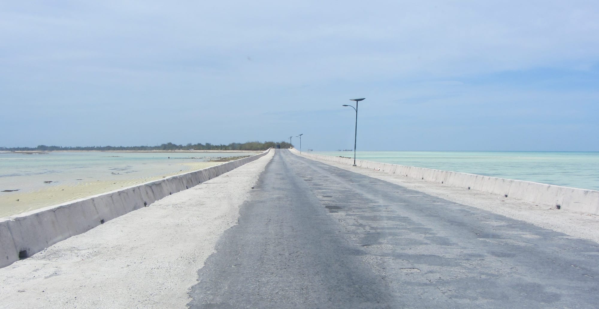
A straight concrete causeway road running low above pale shallow water on both sides towards a line of palms

Kiribati

Tarawa

The causeway between Bairiki and Betio on South Tarawa, with the lagoon on one side and the reef flat on the other. (Flexmaen / Wikimedia Commons · CC BY-SA 4.0)

Kiribati's main atoll, a triangle of reef and low islets just north of the equator. Its southern arm, joined by causeways into one long strip of townships, holds the government, the airport, the port and most of the country's people, while North Tarawa stays rural. Betio, at the western end, was the site of a fierce 1943 battle.

Neighbourhoods

  • Betio
    • History
    • Local life
    • Close to the port

    The islet at the western tip, the country's largest township and the site of the 1943 battle, with Japanese bunkers and guns between houses and along the shore. The deep-water port, the fishing fleet, warehouses and the fish market are here, and a long causeway links it to the rest of the atoll.

    Open in Maps
  • Bairiki
    • First-time visitors
    • Government district
    • Close to public transport

    The administrative centre, with most government ministries, foreign high commissions and the national stadium in a few blocks between lagoon and ocean. Minibuses stop constantly, offices empty in the middle of the afternoon, and the football and athletics ground doubles as the town's meeting place.

    Open in Maps
  • Bikenibeu
    • Guesthouses
    • Markets
    • Quiet and residential

    The main township of the eastern half of South Tarawa, with the country's main hospital next door at Nawerewere, a teachers' college, the Te Umanibong cultural centre, churches and several of the atoll's guesthouses. It is greener and a little less pressed than Betio, with a busy market and lagoon beaches nearby.

    Open in Maps
  • Bonriki and Temwaiku
    • Close to the airport
    • Beaches

    The eastern end of the strip, where the international airport takes up much of the width of the island above the freshwater lens that supplies the town. Beyond it the land broadens into Temwaiku, low, swampy and partly reclaimed, with sparse housing and wide, empty reef flats.

    Open in Maps
  • North Tarawa
    • Village life
    • Beaches
    • Quiet and residential

    The chain of islets running north from Buota, which is reached by road across the bridge from South Tarawa; beyond it travel is by boat, or on foot across the channel to Abatao at low tide. Villages here live by fishing and coconuts, with a handful of simple lodges and none of the traffic of the south.

    Open in Maps

Things to do

The battlefield on Betio

  • Betio battlefield relicslandmark

    Concrete bunkers, a command post and large coastal guns from the Japanese defences of 1943 stand around Betio's shoreline, some half buried in sand, others among houses.

    Open in Maps
  • Betioneighborhood

    The densely built western islet, with the country's main port, the fish market and the concrete remains of the 1943 defences standing among the houses.

    Open in Maps

Along South Tarawa

  • Bairikineighborhood

    The government township, where most ministries, the foreign high commissions and the national stadium sit within a few minutes' walk of both the lagoon and the ocean shore.

    Open in Maps
  • Bikenibeuneighborhood

    The eastern township, with the country's main hospital just beyond it at Nawerewere, the Te Umanibong cultural centre and a busy market.

    Open in Maps
  • Bonriki International Airporttransit hub

    The country's international gateway at the eastern end of the strip, a single runway across the width of the island, and an event in itself on flight days.

    Open in Maps

Beyond the capital

  • North Tarawaneighborhood

    Quiet villages, lagoon beaches and coconut groves on the islets north of Buota, a different world an hour from the capital.

    Open in Maps
  • Abaiangattraction

    The neighbouring atoll to the north, reached by boat or a short flight, with early mission churches and a very traditional village life.

    Open in Maps
  • Maianaattraction

    A small atoll just south of Tarawa across a deep passage, visited for its lagoon, its fishing and its quiet.

    Open in Maps

Seasonal events

  • Independence DayJuly

    Kiribati marks independence on 12 July with parades, dancing competitions between village and island teams, canoe and running races and days of feasting across South Tarawa.

  • Christmas and New YearDecember and January

    Church services, choir competitions and long nights of dancing in the maneaba make this the most sociable season of the year, with many families travelling between islands.

Eat and drink

Long-standing places and food districts in Tarawa. Hours, ratings and directions come from your maps app, always current.

Markets and food streets

  • Betio market and fish stallsmarket

    A market beside the port, selling reef fish and tuna straight off the boats, coconuts, pandanus, imported rice and flour, and cooked food to take away.

    Open in Maps
  • Bairikineighborhood

    The government township has the atoll's cluster of small eateries and takeaways, mostly Chinese-run or serving rice plates with fish and chicken to office workers.

    Open in Maps
  • Bikenibeuneighborhood

    Guesthouse dining rooms and a few simple restaurants along the eastern township's main road, where the cooking leans on fresh fish, rice and coconut.

    Open in Maps

Experience Tarawa

History

Tarawa was settled by Micronesian voyagers long before written records, and Gilbertese tradition links the atoll to Samoan arrivals who reshaped its clans and the seating order of its maneaba. Its islets were a cluster of village districts living on fish, coconut, pandanus and swamp taro, with the great meeting houses as their parliaments. Whalers and traders appeared in the nineteenth century, missionaries followed, and in 1892 the Gilbert Islands became a British protectorate, administered for decades from the phosphate island of Banaba rather than from here.

The atoll's name became widely known in November 1943. Japanese forces had fortified Betio, the small western islet, with bunkers, coastal guns and an airfield, and a United States amphibious assault took it in about three days of fighting on ground barely a few kilometres long. More than a thousand American servicemen were killed, along with almost the entire garrison of roughly four and a half thousand Japanese troops and Korean labourers. The relics of those days still lie along the Betio shore.

After the war the colonial headquarters moved to Tarawa, and Bairiki became the seat of government of the Gilbert and Ellice Islands Colony and then, from independence in 1979, of Kiribati. People moved in from the outer islands for schools, hospitals and wage work, causeways built with Japanese aid from the 1980s tied the southern islets into a single strip, and the population multiplied. South Tarawa has since become one of the most densely populated places in the Pacific, and coastal erosion, seawalls and freshwater supply dominate local politics.

Culture & Customs

The maneaba still governs social life. Each village has its open-sided meeting house with a high thatched or iron roof, where matters are talked through until consensus is reached and where families hold inherited sitting places, or boti, by clan. Elders speak first, and courtesy towards them is the first rule a visitor notices. Even in the crowded townships, a new arrival is placed socially by island of origin and clan.

Dance is the art form I-Kiribati are proudest of. Te mwaie covers a range of forms, from the standing dance with sharp, birdlike movements of the head and arms to the seated chants that drive it, performed to clapping and to a wooden box beaten as a drum. Groups rehearse for months for Independence Day competitions, and the costumes of pandanus fibre, shells and coconut are made by hand. Church choirs are the other great collective music, and Catholic and Protestant congregations compete keenly.

Fishing and the sea remain the measure of skill: canoe building, reading swells and stars, tapping coconut palms for sweet or fermented toddy. Many families have a father or son working on foreign ships, and their remittances and absences shape household life. Football, volleyball and athletics fill the evenings at the Bairiki national stadium, and cinema and karaoke bars provide the rest of the atoll's night-time entertainment.

Daily Life

More than 70,000 people live on South Tarawa, more than half the country's population, on a strip of coral sand rarely more than a few hundred metres wide. Housing is a mix of concrete block and timber-and-thatch, packed tightly on Betio and Bairiki and thinning eastwards. Water comes from rainwater tanks and from wells drawing on the thin freshwater lens under Bonriki and Buota, and both sources are under strain; power cuts, crowded households and stretched sanitation are daily realities.

Work is government, the port, shops and schools, supplemented by fishing and by the wages of seafarers abroad. The national budget leans on licence fees from foreign tuna fleets, on a trust fund built from old phosphate royalties and on aid, and public employment is the largest formal employer. Unemployment among young people is high, and many wait for a place on a ship or a chance to study overseas.

Days start at dawn, with minibuses filling the road, market stalls opening and children walking to school in uniform; the middle of the day is hot and slow; the cool of the late afternoon brings volleyball, fishing from the reef and groups sitting out under the palms. Sunday belongs to church. The long-term worry is unavoidable here: king tides that wash across the road, saltwater in the taro pits, seawalls under constant repair, and a national conversation about how long the atoll can carry so many people.

Food

Tarawa eats from the reef, the lagoon and the coconut. Fish is the constant — tuna, bonefish, mullet, octopus and shellfish — grilled over coconut husks, simmered in coconut cream, dried in the sun, or served raw in lime juice with grated coconut. Te bwabwai, the giant swamp taro grown slowly in dug pits and fed with mulch for years, is the prestige food, brought out for feasts and church occasions rather than eaten every day.

Coconut runs through everything. Te karewe, the sweet sap tapped from the flowering spathe of the palm, is drunk fresh in the morning, boiled down into te kamaimai syrup that is poured over almost anything, or left to ferment into a strong drink whose consumption is a recurring social problem. Pandanus is worked hard too, chewed fresh from the key, or cooked and dried into te tuae cake and ground into te kabubu flour, mixed into a dark, nutty drink. Breadfruit and papaya fill the gaps.

Imported staples now dominate the shops: white rice, flour, sugar, instant noodles, tinned corned beef and fish, and sweet drinks, all of which have driven very high rates of diabetes. Betio's market is the place to see the fresh side of the diet, with the morning catch laid out beside coconuts and bundles of pandanus, while the townships' small restaurants serve rice plates, fried chicken and Chinese dishes to office workers.

Planning tools

Budget

Tarawa is expensive for what it offers, because nearly everything is shipped in and there are very few rooms. Hotels and guesthouses are the main cost, followed by boat hire to North Tarawa or a fishing trip. There is little else to spend money on: minibuses cost pennies, the beaches and the battlefield are free, and market food is cheap.

Daily Budget Midrange
USD 130–230 (hotel room, restaurant and guesthouse meals, a boat or fishing charter)
Daily Budget Shoestring
USD 60–100 (village guesthouse, market food and rice plates, shared minibuses)

Cash in Australian dollars is essential, as cards are rarely accepted and the few ATMs are unreliable; bring enough for the whole stay plus a margin for delayed flights.

Best Time to Visit

May to October is generally drier and a little less humid, with steadier trade winds and calmer lagoon water. November to April is wetter, though rainfall varies enormously from year to year with El Niño and La Niña, bringing either heavy rain or drought. July, with the independence celebrations, is the liveliest month.

Suggested Number of Days

Two or three days are enough for the capital strip and its wartime remains. Five to seven suit anyone adding a quieter atoll, which depends on boats and thin flight schedules. Flight days often dictate the length of a stay more than interest does.

First Visit
2–3 days
With Surroundings
5–7 days

Transportation

One road runs the length of South Tarawa, from Betio to the eastern villages, and shared minibuses run it constantly, stopping anywhere on a wave. Fares are low and vehicles crowded. Taxis and a few hire cars exist in the townships. North Tarawa is reached by the bridge at Buota and then by small boat or across the flats at low tide.

Minibuses thin out after dark and on Sundays; boats to North Tarawa and the outer atolls run to the tide and the weather rather than to a timetable.

Airport & Station Connections

Bonriki International Airport, at the eastern end of South Tarawa, has flights from Fiji and, on some routes, via Nauru, with onward Air Kiribati services to the outer islands. Schedules are sparse and change often. Cargo and passenger ships call at Betio. Nearly all visitors arrive by air and travel the strip by minibus or hotel pick-up.

Walkability

Individual townships are easy to walk, and the atoll is never more than a few hundred metres wide, so both shores are always close. Walking between townships is another matter: distances along the single road run to several kilometres, there is little shade, the verges are used by vehicles, dogs and pedestrians together, and the equatorial sun is punishing from mid-morning.

Safety

Serious crime is rare and visitors are seldom troubled; theft from unlocked rooms and alcohol-related disorder at weekends are the common problems, along with roaming dogs. The bigger risks are practical: basic medical care, with serious cases evacuated to Fiji or Australia, water quality and sanitation on crowded South Tarawa, dengue, heat, and strong currents in the lagoon passes.

Carry comprehensive insurance including medical evacuation, drink treated or bottled water, ask locally before swimming near the passes, and walk facing traffic on the main road. Check current official travel advice before travelling.

Climate

Equatorial, hot and humid all year, with temperatures usually between 26°C and 32°C and no real seasons. Rainfall is the variable, swinging with El Niño and La Niña between drenching years and long droughts that stress the freshwater lens under the islets. Cyclones are rare this close to the equator, but king tides flood low ground.

Summer
no summer as such — December to April is the wetter half of the year, with highs near 31°C, heavy showers and high humidity
Winter
no winter either — May to October keeps highs near 30°C, with steadier trade winds, slightly lower humidity and less rain

Local Customs

I-Kiribati life turns on the maneaba, the village meeting house, and on respect shown to elders. Visitors should ask before entering a maneaba, remove footwear and hats, sit rather than stand or walk in front of seated people, and wait to be shown a place. Modest dress matters: shorts and swimwear are for the beach, and women generally keep shoulders and thighs covered in villages. Sunday is for church, and most things close.

Greet people in passing, ask before photographing anyone, a house, or a maneaba, and accept offered food or drink even in small amounts. Land and reef rights belong to families, so ask before fishing or crossing. Tipping is not expected.

Common Payment Methods

The currency is the Australian dollar, alongside a few locally issued coins. Cash is the only reliable means of payment: cards are accepted at one or two hotels at most, the handful of ATMs in the townships often run out or fail, and nothing outside South Tarawa takes plastic. Bring Australian dollars in small notes.