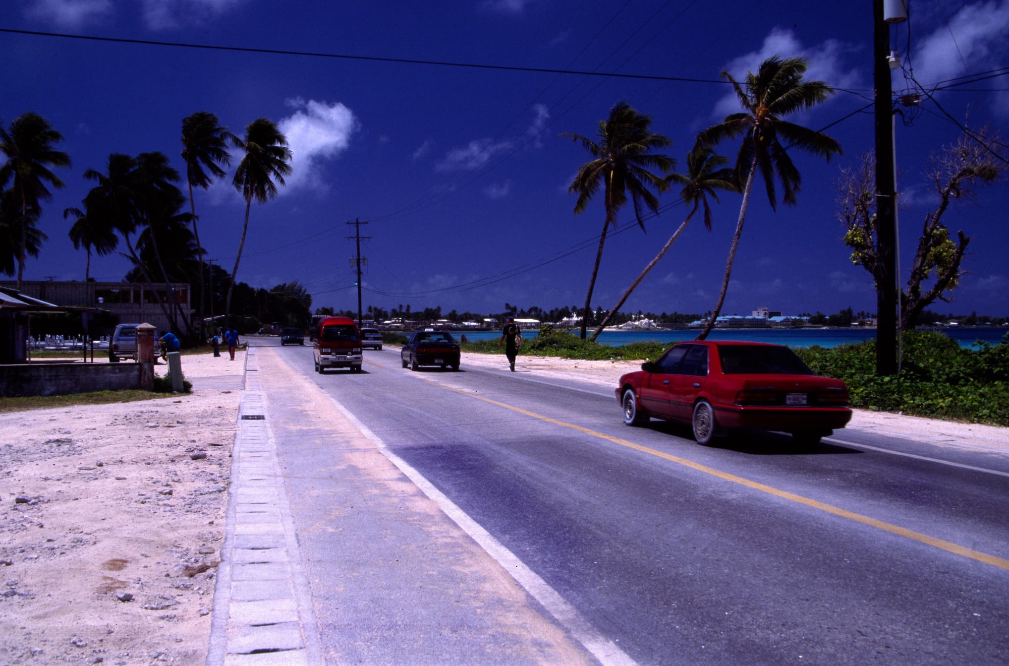
A single paved road running between coral sand and coconut palms, with the lagoon and distant islets to the right

Marshall Islands

Majuro

The main road through Majuro, with the lagoon shore on one side and the atoll's ocean side on the other. (mrlins / Wikimedia Commons · CC BY 2.0)

The capital atoll of the Marshall Islands, a thread of coral islets curving for some 30 miles around a wide lagoon in the central Pacific. Its eastern end is a crowded town of government offices, shops and a busy tuna port; the western end, at Laura, keeps beaches, breadfruit trees and village quiet.

Neighbourhoods

  • Delap, Uliga and Djarrit
    • First-time visitors
    • Government district
    • Best for food

    Three joined islets at the atoll's eastern end, known together as DUD, forming the only real town in the country. Ministries and the seat of parliament are in Delap, the national museum, shops, banks and hotels in Uliga, and dense housing in Djarrit.

    Open in Maps
  • Rairok and the airport side
    • Close to the airport
    • Local life

    The stretch west of the town where the airport runway takes up much of the narrow land. Housing spreads along the road beside it, and the capital's piped water is collected from a catchment basin on the runway.

    Open in Maps
  • Laura
    • Beaches
    • Quiet and residential
    • Picnics

    The village at the far western end of the road, about an hour's drive from town on the widest land of the atoll. There are breadfruit and pandanus trees, gardens and a long sandy beach on the lagoon, and weekends bring families out from the capital. Laura holds the highest ground on the atoll, about 10 feet above the sea, and a freshwater lens that much of Majuro relies on.

    Open in Maps
  • The lagoon islets
    • Snorkelling
    • Day boats
    • Quiet

    Small uninhabited and lightly used islets scattered around the lagoon rim, reached by boat from the town in anything from twenty minutes to an hour. They offer clear water, coral heads within swimming distance of the sand and complete quiet.

    Open in Maps

Things to do

In the town

  • Alele Museummuseum

    The national museum, archive and public library of the Marshall Islands, holding navigation stick charts, woven mats, canoe and fishing gear, historical photographs and displays on Marshallese culture, and the organiser of the Manit Day celebrations.

    Open in Maps
  • Delap-Uliga-Djarritneighborhood

    The capital's linked islets, where a single road passes offices, churches, stores, the harbour and the tuna transshipment berths within a couple of miles.

    Open in Maps
  • Marshall Islands International Airporttransit hub

    The country's international airport, in Rairok west of the town, built during the Second World War and rebuilt in 1971, and the source of the capital's piped water through the catchment basin on its runway.

    Open in Maps

The western end

  • Laurabeach

    The village and long lagoon beach at the western tip of the atoll, about 30 miles from the town by road, with shade, shallow swimming water and the highest ground on Majuro.

    Open in Maps

Short trips from Majuro

  • Arno Atollattraction

    The neighbouring atoll east of Majuro, reached by boat, with quiet villages, deep-water fishing grounds and beaches almost never visited.

    Open in Maps

Seasonal events

  • Constitution DayMay

    The national holiday on 1 May, marking the 1979 constitution, with parades, sports, canoe and outrigger events, dancing and church services.

  • Manit DaySeptember

    Marshallese culture day, organised by the Alele Museum, with canoe sailing, weaving, traditional food preparation, games and demonstrations of older skills.

  • Christmas church singingDecember

    Church groups rehearse for months and then perform through December with songs, marching and new compositions, in the busiest religious and social season of the year in a country where almost everyone belongs to a church.

Eat and drink

Long-standing places and food districts in Majuro. Hours, ratings and directions come from your maps app, always current.

Where the town eats

  • Uliga and Delapneighborhood

    The capital's small run of restaurants and takeaways, mixing Marshallese fish and rice plates with Chinese, Japanese and American cooking, alongside bakeries selling doughnuts and sweet buns.

    Open in Maps
  • The harbour and fish stallsmarket

    Tuna and reef fish sold near the port and from roadside coolers, sashimi-grade fish among them, at what is by volume the world's busiest tuna transshipment harbour.

    Open in Maps
  • Stores and roadside cookingneighborhood

    Much of daily eating comes from general stores and small stands selling rice, tinned meat, fried chicken, coconuts and cooked breadfruit along the single road.

    Open in Maps

Experience Majuro

History

Majuro was settled by Micronesian voyagers roughly two thousand years ago, part of a culture of exceptional open-ocean navigators who read the way swells bend around islands and recorded those patterns on lattice stick charts. The atoll was a chiefly domain whose land was held in clan parcels through the mother's line, and its wide lagoon made it a natural meeting point for canoe traffic across the Ratak chain.

Germany annexed the Marshalls in 1885 and ran them for copra; Japan took the islands during the First World War and administered them under a League of Nations mandate, building up a small settlement and trade at Majuro. The heavy fortification went to other atolls, and when United States forces landed here at the end of January 1944 the atoll was taken with almost no fighting. Its lagoon then became one of the largest naval anchorages of the Pacific war, crowded with ships supporting operations further west.

After the war Majuro served as an administrative centre of the American-run Trust Territory. Between 1946 and 1958 nuclear tests at Bikini and Enewetak displaced whole communities, and some of those families and their descendants settled here, adding to a steady migration from the outer atolls towards schools, hospitals and wage work. Self-government came in 1979 and sovereignty in free association with the United States in 1986. The town grew into the DUD strip, the road west was pushed through to Laura, and the atoll has since dealt with crowding, king-tide flooding and drought. In August 2025 fire destroyed the parliament building in Delap, along with its library and archives.

Culture & Customs

Majuro is where Marshallese tradition and imported American life sit most closely together. Land and status still descend through the mother's line, and the authority of the iroij, the chiefs, remains part of public life alongside elected government. Obligation to relatives is strong, and food, money and help circulate through families rather than accumulating; a child's first birthday, the kemem, is celebrated with a feast open to the whole community.

Christianity organises the calendar, and almost the whole population belongs to a church. Sundays are quiet and churchgoing, and from early December church groups rehearse and then perform new songs, marching and choreography, filling churches through the Christmas season. Manit Day, organised by the Alele Museum, is the formal celebration of older skills, with canoe sailing, weaving, cooking demonstrations and games.

Those skills are being deliberately kept alive in the capital. Young people are taught to build and sail the outrigger walap, the ocean-going canoe of the Marshalls, and to navigate by wave and star knowledge; weavers produce fine pandanus mats, baskets and fans. Basketball and volleyball dominate evenings, Marshallese is the language of daily life with English used in offices and schools, and the legacy of the nuclear tests remains a defining subject in art, poetry and politics.

Daily Life

About 23,000 people live on Majuro, more than half the country's population, most of them packed into the DUD islets at the eastern end where housing, offices, churches and stores share ground that is only a few hundred yards wide. Laura and the villages along the road are more spacious, with gardens and breadfruit trees; the rest of the atoll rim is thinly used.

The atoll runs on government, the port and fishing. Compact funding from the United States, fishing-licence fees from foreign fleets and a large open ship registry supply much of the budget, while the harbour is one of the busiest tuna transshipment points in the Pacific, with purse seiners transferring catch to carriers in the lagoon. Public employment, shops and shipping provide most wage jobs, and remittances arrive from the large Marshallese community in the United States, which Compact residency allows.

Practical constraints shape the day. Fresh water is harvested from rain and from the airport runway catchment, so droughts bring restrictions; power and imported fuel are costly; and rice, flour and tinned food have displaced much of the traditional diet, with diet-related illness widespread as a result. Shared taxis crowd the road from dawn, offices work through the heat, and late afternoon turns to basketball courts, fishing from the reef and gatherings under the palms. King tides that wash across the road and salt in the ground are ordinary, recurring facts of life here.

Food

Majuro's food begins in the lagoon and the ocean. Tuna is abundant and cheap by world standards, eaten grilled, raw as sashimi, or in soup; reef fish, octopus, clams and lobster come from the flats, and the coconut crab is a delicacy saved for special occasions. Fish is often cooked simply over a fire or boiled in coconut cream, sometimes with lime and chilli.

Breadfruit is the traditional starch, roasted whole in the coals, boiled, or fermented into bwiro, a paste wrapped in banana leaves and baked in an earth oven, which keeps for months and is prized by older Marshallese. Pandanus is chewed fresh from the key and cooked down into a preserve; taro and arrowroot fill out the feast table; and coconut appears at every stage, from the water to drink and the grated flesh for cream to the spongy sprouted coconut eaten as a snack and the sweet sap tapped from the palm. Feast cooking often means pork or chicken in an earth oven, with mats laid out and food shared according to custom.

Everyday eating in the capital is much more imported. Stores sell white rice, instant noodles, tinned corned beef and fish, flour and sugary drinks, and the town's restaurants serve Chinese, Japanese and American dishes alongside rice plates with fish or chicken. Bakeries turn out doughnuts and sweet bread early in the morning, and roadside coolers sell whole tuna and reef fish straight from the boats.

Planning tools

Budget

Majuro is expensive for what it offers, because almost everything arrives by ship or plane. Hotel rooms and boat hire are the big costs; food from stores and small eateries is modest, and the beach, the museum and the road west cost very little. Diving trips and flights to outer atolls sit well above the everyday budget.

Daily Budget Midrange
USD 150–300 (hotel, restaurants, a hired boat or a domestic flight to an outer atoll)
Daily Budget Shoestring
USD 70–120 (guesthouse, store and small-eatery food, shared taxis along the road)

Carry US dollars in cash, since cards are accepted only at a few hotels and shops; a shared boat to a lagoon islet is far cheaper split between several people.

Best Time to Visit

December to April is drier and the most comfortable, with the clearest water for snorkelling and diving. May to November is wetter, with heavy showers and higher humidity. Temperatures barely change. Late September brings Manit Day and early May Constitution Day, the two liveliest weeks in the capital.

Suggested Number of Days

Two or three days cover the capital and the drive along the atoll. Five to seven suit a lagoon trip or a flight to a quieter atoll, which depend on boats and a thin domestic schedule. Delays are common, so extra days are worth allowing.

First Visit
2–3 days
With Surroundings
5–7 days

Transportation

One road runs the length of the atoll, about 30 miles from the town to Laura, and shared taxis work it constantly for a flat fare within the town and a higher one further out. There are a few hire cars and hotel pick-ups. Boats serve the lagoon islets, and small aircraft and a government ship reach the outer atolls.

Shared taxis fill up and make detours, so journeys take longer than the distance suggests; outer-atoll flights are frequently delayed or cancelled, so wide buffers matter.

Airport & Station Connections

Marshall Islands International Airport, still widely called Amata Kabua International Airport, is in Rairok, several miles west of the town centre. Flights connect through Honolulu and Guam on the island-hopper route, with limited other regional services, and Air Marshall Islands flies to the outer atolls. A few cargo ships and occasional yachts also call at the lagoon.

Walkability

The town end is walkable in the sense that everything sits along one street: offices, shops, the museum and hotels are within a mile or two of each other. Pavements are patchy, traffic runs close, and heat and glare make longer walks hard work. Anything beyond the town, and certainly Laura, needs a taxi or a car.

Safety

Serious crime is uncommon and visitors are generally safe, with petty theft, some alcohol-related trouble at weekends and roaming dogs the usual problems. The practical risks matter more: one hospital with limited capacity, medical evacuation to Honolulu for serious cases, strong currents in the lagoon passes, sun and dehydration, and the narrow road shared by vehicles and pedestrians.

Carry insurance that includes medical evacuation, drink bottled or treated water, take local advice before swimming near the passes, and follow official guidance on which areas near the former nuclear test sites are safe to visit or fish. Check current official travel advice before travelling.

Climate

Tropical and humid all year, with highs in the mid- to upper 80s °F and nights only a few degrees cooler. The drier months run about December to April and the wetter ones May to November, when heavy showers are common. Typhoons form further west and rarely strike, but king tides and storm surges flood low ground.

Summer
wet season — highs around 87°F, frequent heavy showers, high humidity and light winds
Winter
drier season — highs around 85°F, steadier trade winds, less rain and the best water clarity

Local Customs

Marshallese society is matrilineal, with land held through the mother's line, and generosity rather than accumulation earns standing. Sunday is for church and rest, and much of the town closes. Dress modestly away from the beach: shorts and swimwear are out of place in town, and women generally keep shoulders and thighs covered. Greetings matter, and yokwe, the everyday hello, carries the sense of love.

Ask before photographing people, houses or church services, ask before crossing land or fishing a reef held by a family, and take care with questions about the nuclear tests, which are a live and painful subject. Tipping is not expected.

Common Payment Methods

The currency is the US dollar. Cash covers almost everything: cards are taken at a few hotels and larger stores in the capital and nowhere on the outer atolls, and the handful of ATMs in Majuro can run out. Small notes are useful for shared taxis, stores and market fish.