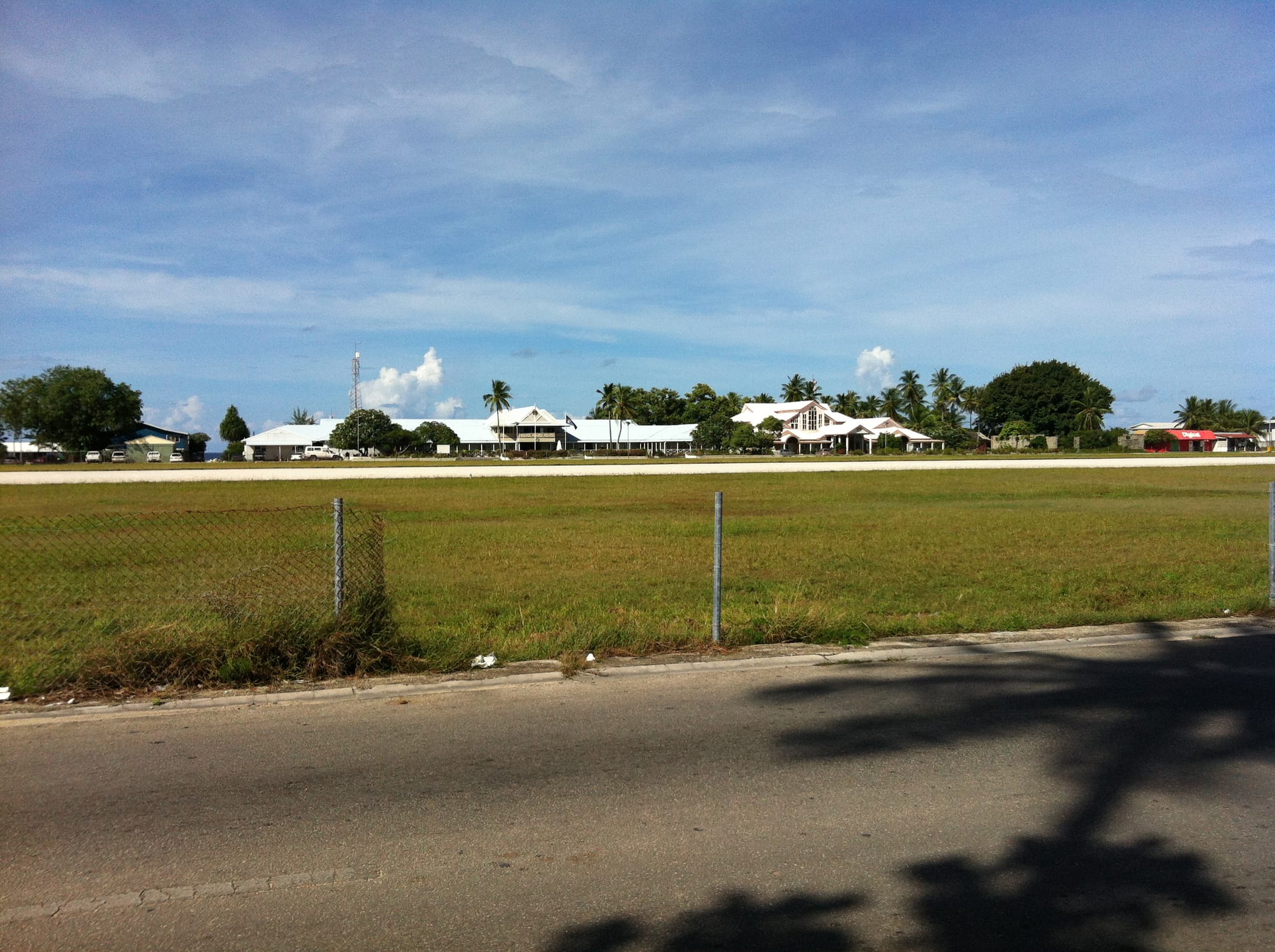
Low white government buildings with palms behind them, seen across grass and the edge of an airport runway

Nauru

Yaren

Government buildings at Yaren, seen across the open ground beside the runway of Nauru's airport. (Sean Kelleher from Melbourne, Australia / Wikimedia Commons · CC BY-SA 2.0)

A district of a few hundred people on the southern coast of Nauru, treated as the country's capital because parliament, the courts and most government offices stand there. It grew around the island's airport and its single runway, and the coast road, the wartime gun positions on the escarpment above and the mined interior are all within a short distance.

Neighbourhoods

  • Yaren
    • First-time visitors
    • Government quarter
    • Close to the airport

    The strip of coast either side of the runway, holding parliament, the courts, government offices, a church and a school. Distances are tiny and everything faces either the sea or the airfield, with the limestone escarpment rising steeply behind.

    Open in Maps
  • Aiwo
    • Shops and services
    • Local life

    The district north-west of Yaren, where the phosphate works, the cantilevered loading berths and the power station stand beside a small commercial centre with shops and offices. The road up to Command Ridge and the interior begins here.

    Open in Maps
  • Meneng and Anibare
    • Beaches
    • Quiet and residential

    The south-eastern and eastern coast, taking in the Menen Hotel, the Meneng stadium and the sandy curve of Anibare Bay with its small harbour. Residential and quieter than the west, and the closest thing on Nauru to a beach district.

    Open in Maps
  • Buada
    • Quiet and residential
    • Inland scenery

    An inland hollow reached by a short climb from the coast, holding Buada Lagoon and one of the few genuinely green, shaded settlements on the island, ringed by coconut palms and gardens between the mined fields.

    Open in Maps

Things to do

The government quarter

  • Nauru International Airporttransit hub

    The country's single airport, whose runway runs the length of Yaren; the coast road crosses it and closes when aircraft land.

    Open in Maps
  • Parliament Houselandmark

    The modest parliament building in Yaren, together with the courthouse and government offices that make the district Nauru's seat of administration.

    Open in Maps
  • Yarenneighborhood

    The district itself can be walked end to end in half an hour, past offices, a church and open ground between the runway and the reef.

    Open in Maps

Wartime remains

  • Command Ridgeviewpoint

    The island's highest point, at 65 metres, where rusting Japanese guns and the remains of their communications bunker overlook the whole island and the pinnacle fields.

    Open in Maps
  • Japanese gun emplacements above Yarenlandmark

    Concrete positions and coastal guns left from the Japanese occupation of 1942–45 stand on the escarpment and along the shore near the district.

    Open in Maps

Coast, lagoon and the interior

  • Anibare Baybeach

    The island's main stretch of sand, on the east coast about four kilometres from Yaren, with coral pinnacles offshore and a small boat harbour; currents and reef make swimming hazardous.

    Open in Maps
  • Buada Lagoonattraction

    A slightly brackish lake, the only true lake on Nauru, ringed by palms in a hollow in the middle of the island and one of the few green places left after mining.

    Open in Maps
  • Moqua Wellattraction

    An underground freshwater pool in a limestone cave in Yaren itself, historically one of the island's few sources of fresh water.

    Open in Maps

Seasonal events

  • Independence DayJanuary

    Nauru's national day on 31 January marks independence in 1968, with sports, church services and community events across the districts.

  • Constitution DayMay

    A public holiday in May marking the adoption of the constitution, observed with official ceremonies and family gatherings.

  • Angam DayOctober

    Held on 26 October, it commemorates the occasions when the Nauruan population recovered to 1,500, the number long thought necessary for the community to survive.

Eat and drink

Long-standing places and food districts in Yaren. Hours, ratings and directions come from your maps app, always current.

Everyday eating

  • Takeaways and restaurants near the airportrestaurant

    A small number of eating places, several of them Chinese-run, serve rice and noodle dishes, fried chicken and fish in and around Yaren and neighbouring districts.

    Open in Maps
  • Shops and canteensmarket

    General stores and canteens stock imported rice, tinned meat and fish, instant noodles, frozen goods and soft drinks, which make up much of the island's diet.

    Open in Maps

Fish and local food

  • Fresh fish from the boatsmarket

    Tuna and reef fish are sold directly by fishermen on the coast road and at Anibare harbour, and are cooked at home or grilled for church and family occasions.

    Open in Maps
  • Coconut and pandanusmarket

    Coconut, pandanus and a little home-grown fruit are the surviving local produce on an island with almost no cultivable land left.

    Open in Maps

Experience Yaren

History

Yaren is one of the fourteen districts of an island settled about three thousand years ago by people organised into twelve matrilineal clans. Its shoreline was a fishing and coconut district like the others, and the freshwater cave at Moqua, in the district itself, mattered island-wide in times of drought. Germany annexed Nauru in 1888, and after phosphate rock was identified in 1900 the island's interior was progressively dug away by a succession of foreign administrations — Germany, then Australia, New Zealand and Britain under a League of Nations mandate.

The Japanese occupation of 1942–45 left the heaviest mark on the south of the island. Airfields were built, gun positions and bunkers were set into the escarpment above Yaren, and 1,200 Nauruans were deported to Chuuk as forced labour, of whom 745 survived to be repatriated; others went hungry at home as air attacks cut off supplies. Concrete remains of that period still stand above the district, and the wartime airstrip became the basis of the airport that runs the length of Yaren today.

After independence in 1968 the republic took over the phosphate operation, control passing to a locally owned corporation in 1970, and royalties were very high through the 1970s and 1980s. Yaren acquired the parliament, courts and offices that made it the country's seat of government, although Nauru's constitution names no capital. The income was largely lost to poor investments, and by 2000 the accessible ore was nearly exhausted and the state close to bankruptcy. Since 2001 Nauru has drawn much of its revenue from hosting Australia's offshore asylum-processing arrangements, alongside fishing licences and aid. In May 2026 a constitutional amendment changed the country's official English name to the Republic of Naoero, notified to the United Nations that June.

Culture & Customs

Life in Yaren, as everywhere on Nauru, runs through clan and family. The twelve clans are traced through the mother's line, and relationships between them govern land, obligation and much of daily conduct on an island where almost everyone is related to almost everyone else. Church is the other great institution: the Nauruan Congregational church and the Catholic parish both have buildings in the district, and Sunday services, choirs and youth groups take up a large part of the week.

Older practices survive in memory and in occasional demonstration rather than in daily use — the catching and taming of frigatebirds, which were kept and used to help with fishing, navigation by stars and swell, and the raising of milkfish in brackish ponds. Angam Day, in October, is the most distinctively Nauruan commemoration: it marks the two occasions when the population recovered to 1,500 after catastrophe, and is taken seriously as a celebration of survival.

Sport is the main public entertainment. Australian rules football is the national team sport and is played on the grounds at Meneng and Aiwo, weightlifting is a national pastime and the country's main Olympic and Commonwealth Games sport, and the island follows Australian competitions closely. Social life is informal and unhurried: people gather under trees and on verandas in the cool of the evening, drive the ring road for its own sake, and expect visitors to greet them and to explain themselves.

Daily Life

Fewer than a thousand people live in Yaren, out of an island population of about twelve thousand, all of them on the narrow coastal strip; the interior, known as Topside and covering most of the island, is a wasteland of jagged limestone pinnacles left where the phosphate was cut away. Government is the principal employer, and most of it is in this district, along with the courts, the airport and the offices of the state-owned companies. The regional processing arrangements made with Australia, the phosphate operation at Aiwo and fishing-licence revenue account for most of the rest of the economy.

Almost everything is imported by ship and unloaded at the Nauru International Port at Aiwo. Electricity comes largely from diesel generators and water from rain catchment and a desalination plant. Shortages of fuel, fresh produce and water occur, and prices are high.

The day begins early and slows in the middle, with offices and schools working through the morning, the ring road busy with short car journeys, and evenings given to family, church and sport. Health is the island's largest public problem: the loss of the traditional diet and of land on which to grow food has left Nauru with some of the world's highest rates of obesity and type 2 diabetes. The government's more recent revenue proposals — deep-sea mining of metal-rich nodules through a sponsored company, and a scheme selling citizenship to raise money towards moving much of the population to higher ground — are both contested, the first particularly by environmental organisations.

Food

Nauruan food was always limited by the size of the island: coconut in every form, pandanus fruit, reef and ocean fish, seabirds, and milkfish raised in brackish ponds and in Buada Lagoon. Fish remains the one abundant fresh ingredient, and tuna and reef fish bought from the boats or the roadside are grilled, fried or cooked in coconut milk for family meals and church gatherings.

Everyday eating is now overwhelmingly imported. Shops in and around Yaren sell white rice, tinned corned beef and fish, instant noodles, frozen chicken, biscuits and sugary drinks, and these make up the bulk of most households' diet — the direct cause, in the government's own assessment and in that of health researchers, of the country's diabetes epidemic. Very little is grown, because the mined interior offers almost no soil and the coastal strip is built over.

There is no restaurant scene to speak of: a handful of places in and near the district, several of them Chinese-run, serve rice and noodle dishes, fried chicken and fish, and the hotels provide the rest. Imported beer and soft drinks are otherwise the norm. Coconut crabs and seabirds, once part of the diet, are now rarely eaten. Feast cooking for weddings, funerals and church anniversaries is where Nauruan food is still seen at its fullest, with fish, rice, pork and coconut dishes laid out for large numbers of relatives.

Planning tools

Budget

Nauru is expensive for what it offers: a couple of basic hotels, imported food and very little tourist infrastructure. Accommodation and a vehicle are the main costs, and there is little to spend money on beyond meals and fuel. The Australian dollar is used, and this is very much a cash economy.

Daily Budget Midrange
USD 170–270 (better room, restaurant meals, a hired car, a boat trip)
Daily Budget Shoestring
USD 100–150 (the cheaper hotel, store and takeaway food, a shared vehicle)

Bring Australian dollars in cash for the whole stay, as card acceptance is minimal and the island's ATMs cannot be relied on.

Best Time to Visit

There is no tourist season. The drier, breezier trade-wind months from about April to October are marginally more comfortable, while November to February is wetter and heavier, though rainfall is erratic and drought can last for years. Independence Day in January and Angam Day in October are the liveliest times on the island.

Suggested Number of Days

Two or three days covers the island, which can be circled by car in well under an hour. The flight schedule, rather than the amount to see, usually decides how long a visit lasts.

First Visit
2–3 days
With Surroundings
3–4 days

Transportation

A single sealed ring road circles the island, crossing the airport runway in Yaren, with a second road climbing inland to Buada and Topside. There is no public transport; a few informal taxis operate and hotels arrange cars and drivers. Driving is on the left, and speeds on the ring road are often high for such short distances.

Fuel supply depends on shipping and can be interrupted, so it is worth asking about availability before hiring a vehicle.

Airport & Station Connections

Nauru International Airport in Yaren is the only way in for visitors. The government-owned Nauru Airlines flies to Brisbane several days a week, with less frequent services to other Pacific destinations including Nadi in Fiji and Tarawa in Kiribati. There are no passenger ferries, and the island has no natural harbour, though cargo ships are handled at the Nauru International Port at Aiwo. Almost every visitor needs a visa arranged in advance.

Flights are few and disruptions ripple across the region, so allow spare days and confirm the visa and accommodation before booking.

Walkability

Yaren itself is easily walked: offices, parliament, the church and the shoreline are all within a few hundred metres, and the district is flat. Beyond it the ring road has no pavements and little shade, the equatorial sun is fierce, and vehicles move quickly, so walking any distance is uncomfortable rather than dangerous.

Safety

Crime is low in such a small, close-knit society, with occasional alcohol-related trouble. The real concerns are practical: medical care is very limited and serious cases are flown to Australia, fresh water is scarce, the sun is extreme, and traffic on the ring road is fast. Swimming is hazardous along most of the coast because of the reef and currents, and the abandoned mining ground inland has unstable pinnacles and open pits.

Swim only where local people do, carry water and sun protection, keep away from the edges of mined ground and the industrial areas, and travel with insurance that covers medical evacuation. Check current official travel advice before travelling.

Climate

Equatorial, hot and humid all year, typically between 25 and 35°C, with persistent trade winds from about April to October. A wetter season runs from November to February, but rainfall is unreliable and multi-year droughts occur — a serious matter on an island dependent on rain catchment and a desalination plant. Nauru lies outside the main cyclone belt.

Summer
hot and humid, in the low 30s°C by day, with heavier rain and less wind from about November to February
Winter
much the same, in the low 30s°C by day, but drier and breezier from about April to October

Local Customs

Nauruan society is built on twelve matrilineal clans, and Christianity — Congregational and Catholic — shapes the week, with Sunday given to church. Everyone knows everyone, greetings matter, and visitors are noticed immediately. Dress is modest away from the beach, and photography of government buildings, the port, the phosphate works and the regional processing facility is not welcome.

Tipping is not customary. Greet people on the road, ask before taking photographs of people or of official and industrial sites, and be aware that journalists and researchers need specific permission to work on the island.

Common Payment Methods

The currency is the Australian dollar. There is a very limited banking presence, card acceptance is minimal outside the hotels, and ATMs cannot be relied upon, so visitors bring enough cash for the whole stay. Prices for imported goods are high because everything arrives by ship.