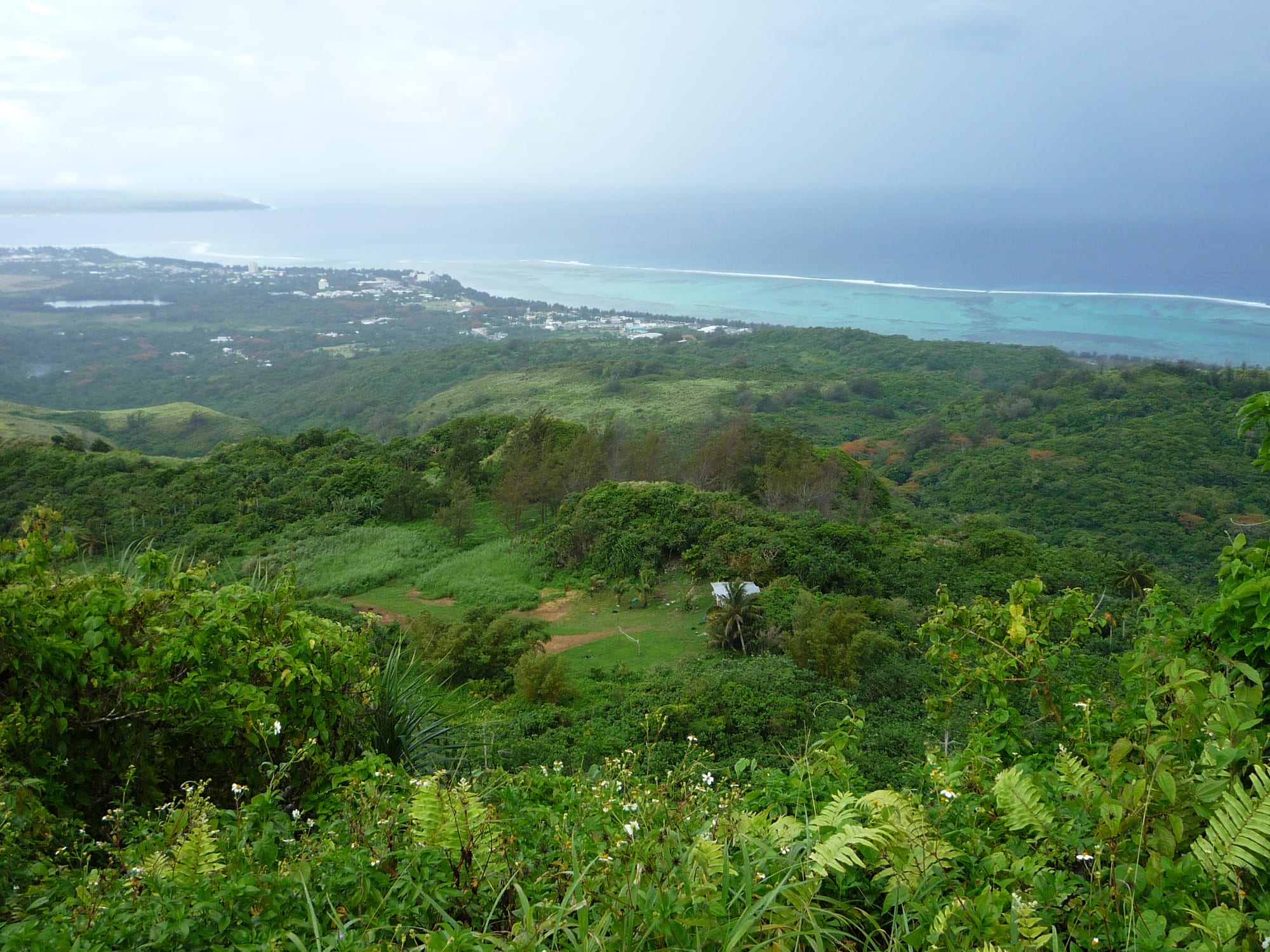
Green hills and jungle falling away to a reef-edged turquoise lagoon and a low coastal town, seen from a high summit under grey cloud

Northern Mariana Islands

Saipan

Saipan's wooded interior, coastal villages and reef-fringed lagoon seen from the summit of Mount Tapochau. (Cla68 / Wikimedia Commons · CC0)

The largest island of the Northern Mariana Islands and the seat of its government, about 120 miles north of Guam. A sugar colony under Japanese rule and the site of one of the Pacific war's bloodiest battles in 1944, it is now a lagoon-fringed tourist island of CHamoru and Carolinian villages, Filipino and Asian communities, dive sites and battlefields.

Neighbourhoods

  • Garapan
    • First-time visitors
    • Beaches
    • Best for food

    The island's tourist centre on the west coast, facing the lagoon. Most hotels, restaurants, bars, duty-free shops and dive operators are here, along with American Memorial Park and Micro Beach. It was a substantial Japanese town before 1944 and was rebuilt from nothing after the battle, so the street grid is modern and low-rise.

    Open in Maps
  • Susupe and Chalan Kanoa
    • Local life
    • Best for food
    • Beaches

    The administrative and residential middle of the west coast, south of Garapan. Government offices, the courts, the civic centre grounds, the Catholic cathedral and a long shallow beach are all in this stretch, with small CHamoru and Filipino eateries along the main roads.

    Open in Maps
  • San Antonio and the south-west coast
    • Quiet and residential
    • Beaches

    The southern end of the lagoon, past the airport turn-off, with residential streets and small beaches used mostly by islanders. Sunsets over the water and views across the channel to Tinian are the draw.

    Open in Maps
  • Capitol Hill
    • Quiet and residential
    • Government district

    A planned settlement on a ridge above the west coast, built by the United States in 1948 and, from 1962, the headquarters of the Trust Territory administration. The Commonwealth's legislature and governor's offices are here, in a cooler, greener setting well above the beach strip.

    Open in Maps
  • Tanapag and San Roque
    • Quiet and residential
    • Local life

    Villages along the northern part of the west coast with strong Carolinian communities, a harbour area, churches and beaches that see few visitors. The road north from here runs on towards the cliffs and wartime sites of Marpi.

    Open in Maps

Things to do

Second World War sites

  • American Memorial Parkpark

    A park on the Garapan shore, owned by the Commonwealth and managed in cooperation with the US National Park Service, with a Second World War museum and a memorial to the more than 4,000 American service members and islanders who died in June 1944.

    Open in Maps
  • Banzai Clifflandmark

    A limestone cliff at the island's northern tip where many Japanese soldiers and civilians died in the last days of the battle in 1944, now a place of memorials and pilgrimage; Suicide Cliff stands on the high ground not far away.

    Open in Maps

Beaches, caves and the lagoon

  • Managahaattraction

    A small uninhabited islet in the lagoon a short boat ride from Garapan, ringed by white sand and clear shallow water, and the island's standard day trip for swimming and snorkelling.

    Open in Maps
  • The Grottoattraction

    A limestone cavern near Marpi, linked to the open sea and about 70 feet deep at its deepest, and one of the island's best-known dive sites.

    Open in Maps
  • Lake Susupepark

    Saipan's only lake, a shallow freshwater body behind the beaches at Susupe, fringed by marsh and reeds and visited by migrating birds.

    Open in Maps
  • Kalabera Caveattraction

    A large limestone cave in the north-east of the island with ancient CHamoru rock art on its walls, used as a shelter during the 1944 fighting.

    Open in Maps

Walks and viewpoints

  • Mount Tapochauviewpoint

    The island's high point, a little under 1,600 feet, reached by a steep track to a summit with a view over the whole of Saipan, the lagoon and the neighbouring islands.

    Open in Maps
  • Bird Island Lookoutviewpoint

    A roadside viewpoint over a rocky, vegetation-topped islet in a surf-washed bay on the north-east coast, part of a protected wildlife area.

    Open in Maps

Short trips from the island

  • Tinianattraction

    The quiet island across the Saipan Channel to the south-west, with latte stones, empty beaches and the wartime North Field airstrips, reached by a short flight.

    Open in Maps
  • Rotaattraction

    A green, little-visited island about 80 miles to the south-west, known for its unfinished latte-stone quarry and quiet beaches.

    Open in Maps

Seasonal events

  • Liberation DayJuly

    Parades, a carnival and village celebrations marking the end of the 1944 fighting and the release of islanders from wartime internment camps — one of the biggest occasions of the Saipan year.

  • Commonwealth Covenant Day24 March

    A public holiday marking the covenant that made the islands a Commonwealth in political union with the United States, codified in American law on 24 March 1976 and marked with ceremonies and family gatherings.

  • Village fiestasthrough the year

    Each village holds a fiesta for its patron saint, with Mass, open houses and long tables of barbecue, red rice and kelaguen to which visitors are often welcomed.

Eat and drink

Long-standing places and food districts in Saipan. Hours, ratings and directions come from your maps app, always current.

Saipan classics

  • CHamoru barbecue standsrestaurant

    Roadside grills and weekend stands selling barbecue chicken and short ribs with red rice, kelaguen and fina'denne' sauce — the standard island plate lunch.

    Open in Maps
  • Filipino turo-turo canteensrestaurant

    Point-and-choose canteens serving adobo, pancit, grilled fish and rice, found in most villages and the cheapest sit-down meals on the island, reflecting Saipan's large Filipino community.

    Open in Maps

Food districts and markets

  • Garapan restaurant stripneighborhood

    The densest choice on the island, with Japanese, Korean, Chinese, Thai, Filipino and American kitchens, bakeries and bars within a few blocks of the hotels.

    Open in Maps
  • Chalan Kanoa and Susupe eateriesneighborhood

    Small family-run CHamoru, Filipino and Korean places along the main roads south of Garapan, where islanders rather than visitors eat.

    Open in Maps

Experience Saipan

History

The Marianas were settled by the ancestors of the CHamoru thousands of years ago, and Saipan's villages sat beside the lagoon long before Europeans arrived. After the Chamorro–Spanish wars, Spain moved most of the northern islands' people to Guam, and Saipan stood almost empty for well over a century. Carolinian voyagers from the atolls to the south settled at Garapan and along the west coast in the early nineteenth century, and CHamoru families returned from Guam, which is why the island has two indigenous peoples today.

Spain sold the islands to Germany in 1899, and Japan took them during the First World War, governing under a League of Nations mandate from 1919. Japanese, Okinawan and Korean settlers came in thousands to work a sugar industry, and Garapan grew into a town with schools, shops, a shrine and a narrow-gauge sugar railway around the coast — its population outnumbered the islanders.

That world ended in June and July 1944. American forces landed on the beaches at Chalan Kanoa on 15 June and fought north for more than three weeks in one of the Pacific war's costliest battles; Garapan was levelled, and the fighting closed with mass civilian and military deaths at the cliffs of Marpi. The United States administered Saipan afterwards, basing the Trust Territory of the Pacific Islands government on Capitol Hill from 1962, a hillside settlement built in 1948. Voters chose Commonwealth status in political union with the United States, effective in 1978, and residents became US citizens in 1986. A garment boom in the 1990s and Asian package tourism since have shaped the modern island, along with Typhoon Yutu in 2018 and the closure of the borders in 2020.

Culture & Customs

Saipan is the cultural centre of the Commonwealth, and its identity rests on two indigenous peoples. CHamoru and Carolinian families keep distinct languages, dances and crafts — Carolinian communities at Tanapag and elsewhere hold on to weaving, canoe-building and the memory of long-distance navigation — while both are bound by clan obligation, respect for elders and a strong Catholic calendar. Each village keeps a patron saint, and its fiesta means Mass followed by open houses and tables of barbecue that anyone may join.

Layer on that the island's other communities. Filipinos make up a large part of the workforce and have brought their own churches, shops and festivals; Japanese, Korean and Chinese businesses run much of the tourist trade; and American institutions, sport and schooling frame public life. English is the working language, with CHamoru, Carolinian and Tagalog heard everywhere.

Public culture is strongest in the open air: Liberation Day parades in July, gatherings on the Susupe civic grounds, fishing derbies, village basketball and softball, and Sunday gatherings on the beaches with generators, coolers and grills. The 1944 battle remains present in memorials, in Japanese and American pilgrimages to Marpi, and in family stories of the internment camps. Visitors are treated with courtesy, and a little formality towards older people goes a long way.

Daily Life

About 43,000 people live on Saipan, nearly nine tenths of the Commonwealth's population, spread through villages along the west coast and across the middle of the island rather than in one dense town. Government is the largest employer, followed by tourism, retail, construction and the small businesses that serve them; a substantial share of workers are from the Philippines and elsewhere in Asia on federal work permits, and many islanders have moved to Guam, Hawaii or the US mainland for jobs and study.

The economy has been unsteady for a generation. The garment factories that once filled industrial lots closed in the late 2000s, the casino project that dominated Garapan in the mid-2010s collapsed, and the flow of visitors from China, South Korea and Japan has never fully returned to its earlier levels. Power and water costs are high, electricity comes from imported diesel, and the utility's rates and outages are perennial local news. Recovery from Typhoon Yutu is still visible in patched roofs and empty shells of buildings.

Days start early and work stops for the hottest hours where it can. Families shop at supermarkets stocked with American and Asian imports, fish from small boats, and gather for baptisms, funerals and fiestas that cross whole extended families. Boxing, basketball and beach barbecues fill weekends, and the American calendar of holidays runs alongside the island's own.

Food

Saipan eats CHamoru at home and Asian out. The local plate is barbecue chicken or short ribs grilled over charcoal with hineksa' aga'ga' — red rice coloured and flavoured with achote seed — and kelaguen, meat, chicken or reef fish dressed with lemon juice, grated coconut, onion and hot pepper. Fina'denne', a sauce of soy, lemon or vinegar, onion and chilli, goes on everything, and kå'du soups and grilled or steamed fish round out a home meal. Apigigi', grated cassava and coconut wrapped in a banana leaf and toasted, is the classic sweet, along with sweet coconut candy and tropical fruit from garden trees.

The island's Filipino community has made turo-turo canteens a daily habit, with adobo, pancit, lumpia and fried fish over rice for a few dollars. Garapan's strip carries Japanese sushi and ramen counters, Korean grills, Chinese kitchens and American burgers and pizza, a legacy of both the tourist market and the decades of Japanese rule. Spam and other tinned meats hold a place in island cooking that predates any fashion for it.

Weekly street markets bring cooks out to sell barbecue, noodles and coconut sweets, and village fiestas produce the biggest spreads of the year. Drinks are mostly imported beer and soft drinks, with fresh coconut water, calamansi juice and local fruit shakes as the island alternatives.

Planning tools

Budget

Prices are American, and almost everything except fish and fruit is shipped in. Hotels in Garapan run from simple guesthouses to lagoon-front resorts, and local eateries are cheap. The real extras are a hire car, which most visitors need, and the boat trips and dives that bring people here in the first place.

Daily Budget Midrange
USD 150–300 (Garapan hotel, restaurants, hire car and fuel, a Managaha trip or two-tank dives)
Daily Budget Shoestring
USD 65–110 (guesthouse, Filipino and CHamoru eateries, a shared hire car)

Village eateries and roadside barbecue cost a fraction of hotel restaurants, and the beaches, war memorials and viewpoints are free.

Best Time to Visit

December to June, the drier half of the year, has the calmest water for diving and boat trips and the most reliable sunshine. July to November is wetter and falls inside the western Pacific typhoon season. Temperatures hardly change from month to month, so the choice is really about rain, sea state and the festival calendar.

Suggested Number of Days

Three or four days is enough for the island itself at an unhurried pace. Allow five to seven to add flights to the neighbouring islands or a series of dives. Wet-season weather and boat cancellations can stretch a visit.

First Visit
3–4 days
With Surroundings
5–7 days

Transportation

A hire car is the normal way to get around; driving is on the right and the island is only about 12 miles long, so nothing is far. There is no general public bus network, though some hotels run shuttles along the Garapan strip and taxis can be ordered by phone. Roads are paved on the main routes and rougher towards the northern sites, and scooters and bicycles suit the coast road.

Fill up in the villages rather than relying on finding a station in the north, and take care on unlit roads after dark.

Airport & Station Connections

Saipan International Airport sits in the south of the island, a short drive from Garapan, about 20 minutes by road. Flights come mainly from Guam — a hop of well under an hour — and from South Korea and Japan, with other Asian routes varying from season to season. Small aircraft link Saipan with Tinian and Rota, and cruise ships call occasionally.

Walkability

The Garapan strip is walkable end to end, and the path through American Memorial Park and along Micro Beach is pleasant on foot. Beyond that the island is built around the car: villages are strung along wide roads with patchy pavements, and the northern sites are miles apart. Heat and humidity make long midday walks hard going.

Safety

Saipan is generally safe, and violent crime rarely touches visitors; theft from parked cars and unattended belongings on beaches is the common problem. The sea is the greater hazard — currents at the Grotto and outside the reef are strong, and drownings happen most years. The island is fully inside the typhoon belt, and Typhoon Yutu caused severe damage in October 2018.

Swimming is safest inside the reef, the Grotto is a guided dive for experienced divers only, valuables should not be left visible in a parked car, and official warnings must be followed during typhoon season. Check current official travel advice before travelling.

Climate

Tropical and humid all year, cooled by trade winds off the lagoon. Daytime temperatures sit in the mid-80s°F in every month and nights are warm. The drier season runs from about December to June and the wetter one from July to November, when rain comes in heavy showers and tropical storms are possible.

Summer
hot, humid and wet — days in the high 80s°F, frequent downpours, and the peak of the typhoon season from August to November
Winter
warm and drier — days in the mid-80s°F, nights near the low 70s°F, steadier trade winds and the calmest diving conditions

Local Customs

Manners are Pacific and Catholic. Elders are greeted respectfully, and the CHamoru mannginge' — lightly taking an elder's hand and bringing it to the nose — is still practised in families. Village fiestas are open-house occasions and guests are pressed to eat. Modest dress is expected away from the beach and in churches, and betel nut, chewed widely across the Marianas, is sold in shops and markets.

Tipping follows American practice at around 15–20 per cent in restaurants, ask before photographing people or family gatherings, and treat the war memorials and cliffs at Marpi as places of mourning rather than sightseeing backdrops.

Common Payment Methods

The currency is the US dollar. Hotels, larger shops and dive operators take cards, but small eateries, market stalls and roadside stands often work in cash, and prices at the till exclude nothing because there is no sales tax on most goods. ATMs are in Garapan, Susupe and the larger shopping centres.