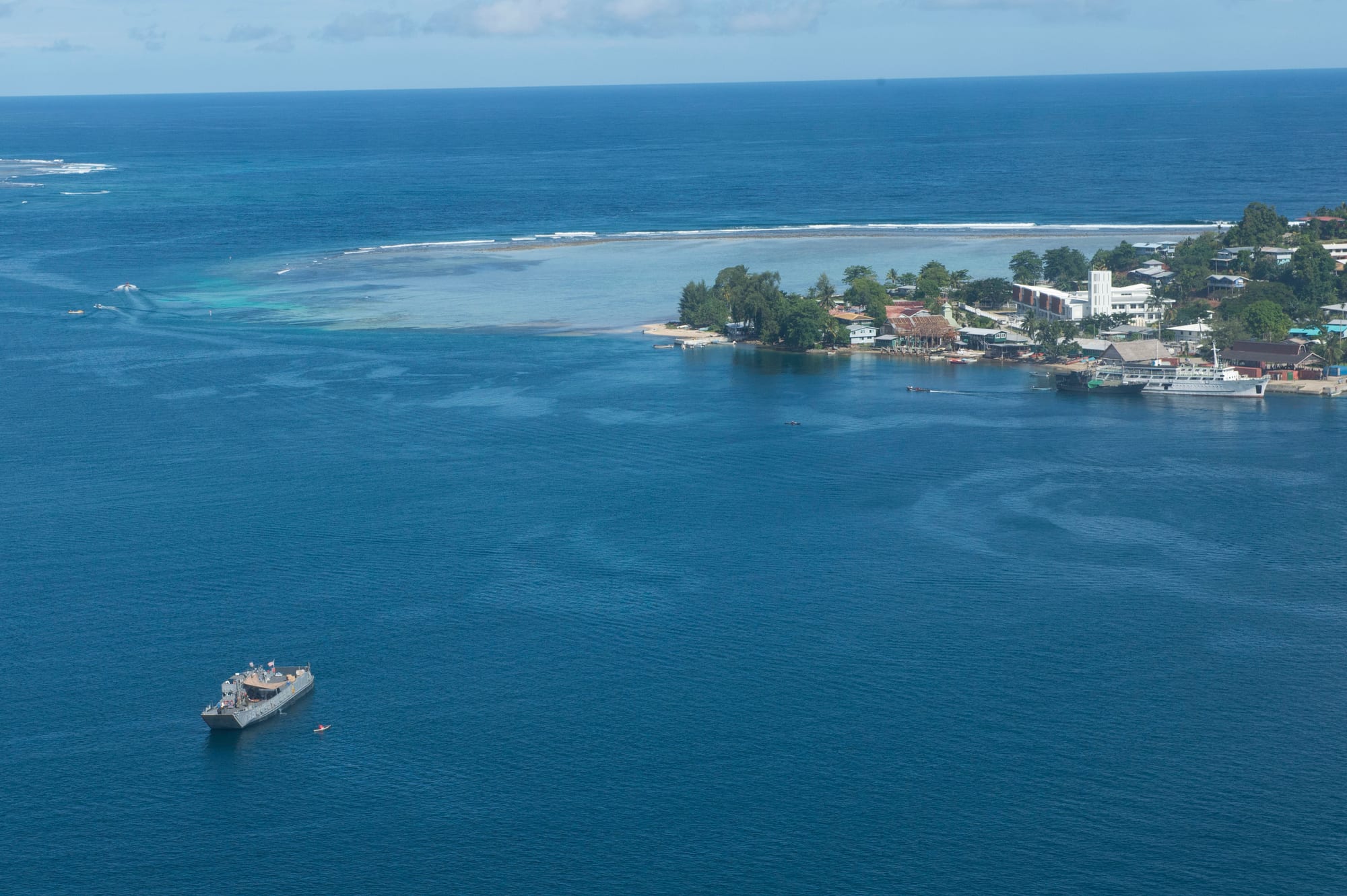
Gizo town seen from the air along a narrow shore of low buildings and palms, with a pale reef shelf, a wharf and deep blue water and a ship offshore

Solomon Islands

Gizo

The coast of Gizo, the main town of the Solomon Islands' Western Province, seen from the air. (Mass Communication Specialist 3rd Class Samantha J. Webb / Wikimedia Commons · Public domain)

The main town of the Solomon Islands' Western Province, set on the sheltered shore of Ghizo Island, just south-west of the larger island of Kolombangara and among reefs and volcanic islands. A government station from 1900, it is now a small provincial capital of wharves, stores and a market, and the base for diving the reefs and wartime wrecks of the New Georgia islands.

Neighbourhoods

  • The waterfront and the main street
    • First-time visitors
    • Markets
    • Boats and transfers

    The single main street runs along the harbour past the market, trade stores, the provincial offices, the hospital and the wharf where ferries and banana boats tie up. Almost everything in town is within a few hundred metres of it.

    Open in Maps
  • The ridge above the town
    • Views
    • Quiet and residential

    Houses climb the steep slope behind the waterfront on tracks and steps, with views across the harbour to Kolombangara. Water and power reach unevenly up the hill, and the walk down to the market is short but steep.

    Open in Maps
  • Titiana and the south-west coast
    • Beaches
    • Local life

    Villages along the coast road west of town, home to many families of I-Kiribati descent who were resettled here from the Phoenix Islands after earlier moves from the Gilbert Islands. Beaches, fishing canoes and church halls line the shore; Titiana was among the places worst hit by the 2007 tsunami.

    Open in Maps
  • The north-west of Ghizo
    • Snorkelling
    • Quiet and residential

    The far end of the island's road, where villages face reef flats and offshore islets used for picnics and snorkelling. It is about half an hour from town by truck or boat.

    Open in Maps

Things to do

Around the town and the island

  • Ghizo Islandneighborhood

    The island that holds the town, 11 kilometres long and 5 wide and rising to 180 metres at Maringe Hill, with villages, gardens and reef flats; the island and its waters are recognised as an Important Bird Area.

    Open in Maps
  • Nusatupe Airporttransit hub

    Gizo's airstrip, built during the Second World War for American operations by flattening two islets and joining them, about 2 kilometres east of Ghizo and still reached from the town by boat.

    Open in Maps

Diving, wrecks and the sea

  • Kennedy Islandbeach

    A small uninhabited island about fifteen minutes by boat from Gizo, known locally as Kasolo, named after John F. Kennedy, whose crew swam to it in August 1943 after their boat was rammed and sunk; it is now a snorkelling and picnic stop.

    Open in Maps
  • Blackett Straitattraction

    The channel between Kolombangara and Arundel Island, where a night action was fought in March 1943 and where PT-109 was run down by a Japanese destroyer that August.

    Open in Maps

Islands nearby

  • Kolombangaraattraction

    An almost perfectly round volcanic island across the strait, about 30 kilometres across and rising to 1,770 metres at Mount Veve, with logging at Poitete and protected upland forest on the high ridges.

    Open in Maps
  • Simboattraction

    A volcanic island south-west of Ghizo, known to early Europeans as Eddystone Island, with the active volcano Ove, saltwater lagoons and a freshwater lake; its northern villages were the worst hit by the 2007 tsunami.

    Open in Maps
  • Ranonggaattraction

    A steep island west of Ghizo that the 2007 earthquake lifted about three metres, pushing out the shoreline and leaving reefs that had been underwater high and dry.

    Open in Maps
  • Vella Lavellaattraction

    A volcanic island north-west of Ghizo, with volcanic cones and a thermal spring, fought over in 1943 after the Allied landings in the New Georgia islands.

    Open in Maps
  • Mundaneighborhood

    The largest settlement on New Georgia, across the water, where the airstrip the Japanese built in 1942 and the Allies took in August 1943 is now an international airport with daily flights to Gizo.

    Open in Maps

Seasonal events

  • Independence Dayearly July

    The national holiday on 7 July, marked in Gizo with a parade along the waterfront, church services, sports and custom dancing.

  • Western Province Day7 December

    The provincial holiday on 7 December, marked in the provincial capital with feasting, sport and custom performances.

  • Dry-season diving monthsJune to September

    Calmer seas and the clearest water bring most divers, yachts and visiting boats to Gizo in the trade-wind months.

  • Christmas and New YearDecember and January

    Churches hold long services and choir competitions, families return to their home villages by boat, and the town is quiet for a fortnight.

Eat and drink

Long-standing places and food districts in Gizo. Hours, ratings and directions come from your maps app, always current.

The market and the waterfront

  • Gizo marketmarket

    The open market beside the wharf, where canoes and trucks bring in reef fish and tuna, taro and cassava, greens, fruit and nuts in season.

    Open in Maps
  • The main streetneighborhood

    The main street's small restaurants, bakeries and trade stores, serving fish and rice, curries, noodles and fried food to a mix of townspeople, officials and divers.

    Open in Maps
  • The hotel and lodge kitchensneighborhood

    Waterfront hotels and island lodges cook the day's catch — tuna, mangrove crab, reef fish — with root crops and coconut cream, and are the usual evening option in a small town.

    Open in Maps

Experience Gizo

History

Ghizo Island was settled long before Europeans arrived, and the New Georgia group around it was known for canoe building, shell valuables and long-distance raiding. In January 1900 the British established a government station at Gizo, with orders to suppress headhunting in New Georgia and the islands around it, and a hospital followed; the town grew as the administrative and trading centre of the Western Solomons, its wharf, stores, offices and hospital strung along one street.

The Second World War reached the district in 1942–43. Japanese forces occupied the islands and built airstrips; Allied landings on New Georgia in mid-1943, the fighting for Munda, and the naval actions in the surrounding straits pushed them out over several months. The channels near Gizo hold the results — sunken transports and warships, aircraft on the reef, and the small island where the crew of the American patrol boat PT-109, commanded by the future president John F. Kennedy, came ashore after their boat was cut in two in Blackett Strait.

Gizo has been the capital of Western Province since independence in 1978, and had 4,620 people at the 2019 census. On 2 April 2007 a magnitude 8.1 earthquake centred about 40 kilometres away sent a tsunami into the town and the villages of Ghizo within minutes; fifty-two people were killed across the province and waterfront buildings were wrecked. The town was rebuilt, and resettlement to higher ground was weighed in the villages worst hit.

Culture & Customs

Gizo is a mixing point for the peoples of the Western Solomons. Villagers from Ghizo, Simbo, Ranongga, Vella Lavella, Kolombangara and the New Georgia lagoons trade and study here, and Solomon Islands Pijin is the common language over many first languages, with English in offices and schools. At Titiana and neighbouring villages on the south coast there are communities of I-Kiribati descent, resettled from the Phoenix Islands after earlier moves from the Gilbert Islands, who keep their own language and fishing traditions.

Church shapes the week. The United Church, heir to the Methodist mission that worked across the Western Solomons, the Catholic cathedral in the town and Seventh-day Adventist congregations all have followings; Sunday is quiet, and in Adventist villages Saturday is the day of rest and pork and shellfish are not eaten. Custom remains the basis of everyday authority outside the town: land and reef belong to clans, chiefs and elders settle disputes, and compensation payments are a recognised way of restoring relations.

The province is known through the country for carving. Nguzu nguzu, the figureheads once fixed to a canoe's prow to give protection on a voyage, along with bowls, spears and model canoes, are made for ceremony and for sale. Head-hunting shrines still stand on islands in the lagoons, music and dance mark every gathering, and betel nut is widely chewed.

Daily Life

Gizo is a town of a few thousand people, small enough to walk across in fifteen minutes and busy in the way that a provincial capital is: the provincial government, the hospital, schools, the police, banks, trade stores and the wharf are the institutions, and the market is where the town gathers. Outside the centre most families live in villages around Ghizo Island and come in by truck or canoe.

Livelihoods are fishing, gardening, and work connected to the sea. Households sell fish and produce at the market, copra and cocoa when prices allow, and the tuna cannery at Noro, along the coast on New Georgia, is a large employer. Diving and lodge tourism provides a modest income for guides, boat crews and cooks, and public-service wages and remittances support many households.

Water, electricity and telephone services are limited and interruptions are normal; freight, fuel and medical cases all depend on boats and small aircraft. People remain conscious of the 2007 tsunami, when the shaking itself was the warning that sent many to high ground before the wave arrived. Logging, reef health and the cost of imported food are steady concerns.

Food

Food in Gizo comes off the reef and out of the garden. Tuna and reef fish are eaten fresh, grilled over coals or cooked in coconut cream, and shellfish, octopus and mangrove crab appear at the market. Taro, cassava, sweet potato and yam are the staples, with taro leaves and other greens, and food is often baked in an earth oven of hot stones covered with leaves.

The market sells cooked food alongside produce, most of it fish or root crops with coconut cream. Canarium nuts, whose trees are a measure of wealth in island society, are picked around September and October, and pawpaw, watermelon, banana and green coconut are sold all year. Poi, made from fermented taro, is served at celebrations, and the families of I-Kiribati descent at Titiana are known for their fishing.

Imported rice, flour, instant noodles and tinned tuna or corned beef make up a large share of the everyday diet in town, and the bakeries turn out bread and buns. The tuna canned at Noro comes from these waters. Drink means green coconut, tea, cocoa and beer in the hotels; kava is not the local custom, and betel nut with lime and leaf takes its place.

Planning tools

Budget

Gizo is cheap to eat and move around in but costly to reach and to dive from. Getting here means a flight or a long ferry ride, guided dives and boat transfers to the outer islands are the main expense, and the few hotels and island lodges are priced well above the town's guesthouses.

Daily Budget Midrange
USD 180–380 (Honiara hotel or island lodge, some domestic flights, guided dives)
Daily Budget Shoestring
USD 55–100 (guesthouse room, market food, shared boats and trucks)

Bring all the cash needed before arriving — banking is limited, cards are accepted almost nowhere, and boat crews, guesthouses and reef-access fees are paid in notes.

Best Time to Visit

June to September, in the drier trade-wind season, has the calmest seas, the best underwater visibility and the most reliable boat transfers. January to March is the wettest period and carries the cyclone risk, when crossings to the outer islands are often cancelled.

Suggested Number of Days

The town itself is small and needs little time. Most visitors stay several days to dive or to reach the surrounding islands, and the number of days depends on how much boat travel is planned and on the weather.

First Visit
1–2 days
With Surroundings
4–7 days

Transportation

The town is walked end to end. A coastal road runs along the south side of Ghizo Island, served by open trucks and shared vehicles to the villages, and everything else moves by water: outboard-powered banana boats, dive-operator boats and inter-island ferries from the wharf. Sea conditions decide the day's plans.

Agree the price of a boat charter and the return time before setting out, and allow spare days in case wind or rain keeps boats in port.

Airport & Station Connections

Nusatupe Airport, on an islet a few minutes across the harbour by boat, takes small aircraft from Honiara in about an hour and a half, sometimes via Munda; hotels and guesthouses meet flights with boats. Passenger ferries from Honiara take most of a day or overnight, calling at Noro and Munda, and cargo boats serve the outer islands from the Gizo wharf.

Walkability

Central Gizo is entirely walkable — market, wharf, offices, shops and hospital lie along one street of a few hundred metres — but there are few pavements and the slope behind the town is steep. Reaching the island's villages on foot is possible and hot; most people take a truck or a boat.

Safety

Gizo is calm and the serious unrest the country has seen has been concentrated in Honiara, not here. Petty theft and occasional break-ins are the main crime risk, and land and reef access is controlled by clans, so a local contact or guide matters. Malaria is present year-round and medical care is very limited: the provincial hospital handles basic cases, and anything serious means evacuation.

Take strict malaria precautions, ask permission before entering land or reefs, treat small-boat travel and sudden squalls seriously, and carry insurance covering medical evacuation. Check current official travel advice before travelling.

Climate

Tropical, hot and humid all year, with days around 30–31°C and nights near 24°C and little seasonal change in temperature. Rain is heavy in every month, with the wettest stretch from December to March and drier, breezier weather in the trade-wind months.

Summer
the wet north-west monsoon season, December to February in the southern hemisphere — around 31°C by day and 24°C at night, humid, with heavy rain and the cyclone risk
Winter
May to October brings south-east trade winds, days near 30°C, nights around 23°C, and calmer, clearer water

Local Customs

Modest dress is expected in town and in villages, with shoulders and knees covered away from the beach or lodge, and swimwear kept to the water. Reefs, beaches and land belong to clans, so a fee and permission are normal for visiting an island or diving a particular reef. Sunday is quiet and given to church, and Seventh-day Adventist villages keep Saturday instead.

Greet people before asking anything, ask before photographing people or villages, and expect to pay a small custom fee for reef and island access; tipping is not expected.

Common Payment Methods

The currency is the Solomon Islands dollar (SBD). Gizo has a bank and an ATM, but they cannot be relied on, and cards are accepted only at a couple of hotels. Everything else — market, boats, trucks, guesthouses, custom fees — is cash, so notes brought from Honiara are the safest arrangement.