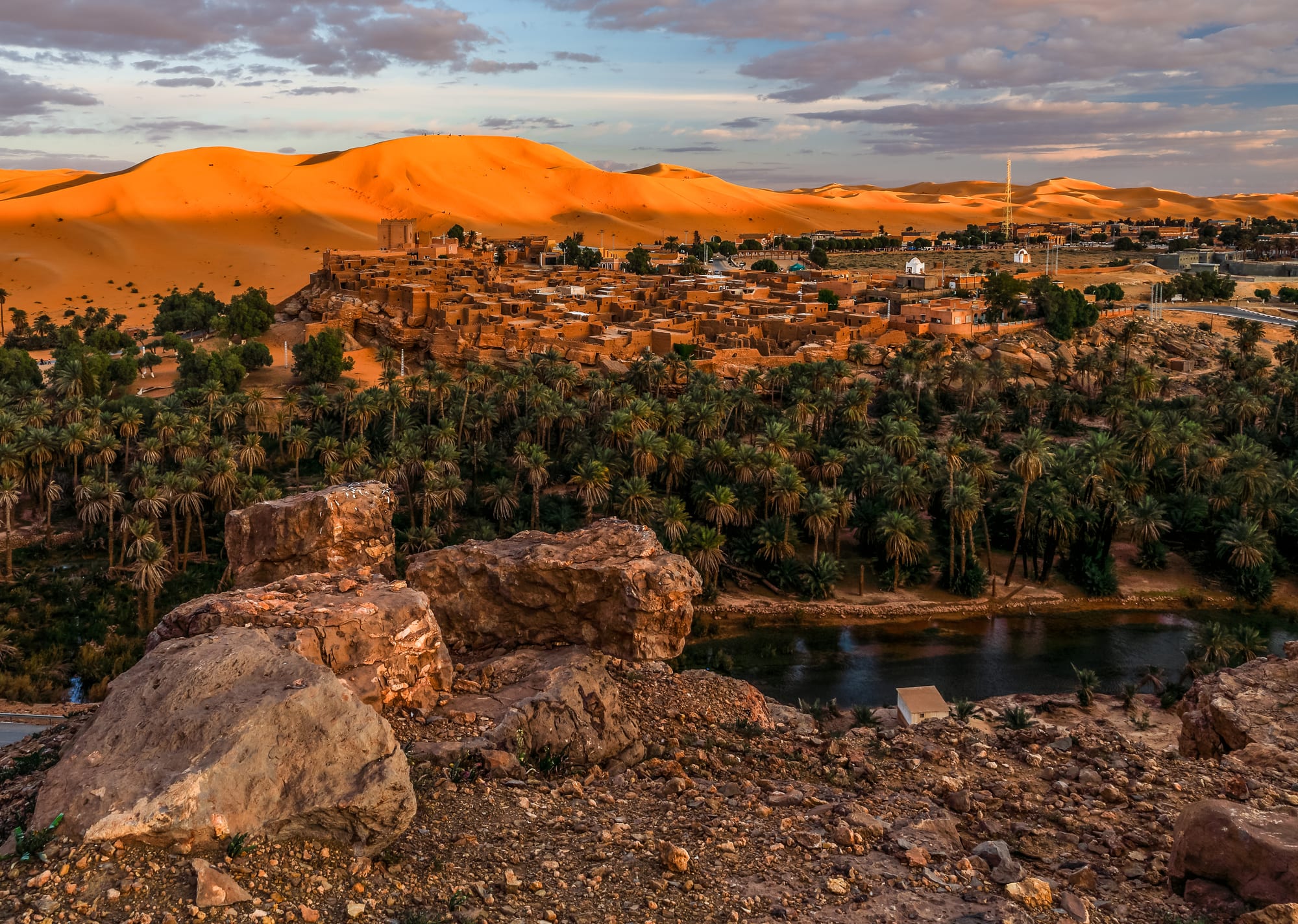
An earthen village on a rocky rise above a dense palm grove and a narrow watercourse, with a long orange dune ridge rising behind it

The Southwest Sahara, Algeria

Taghit

The ksar of Taghit above its palm grove, with the dunes of the Grand Erg Occidental behind. (Chettouh Nabil / Wikimedia Commons · CC BY-SA 4.0)

A small oasis in the Saoura valley of south-western Algeria, set between a palm grove along the Oued Zousfana and a long wall of dunes at the western edge of the Grand Erg Occidental. An old earthen ksar stands on the rock above the palms, and prehistoric engravings survive in the hills nearby.

Neighbourhoods

  • The ksar
    • Historic district
    • Architecture
    • Views

    The old fortified village of mud brick and stone on the rock above the palm grove, its lanes narrow, partly roofed and stepped. Much of it is ruined and some houses are still lived in; from its edge the whole oasis and the dune wall behind it are in view.

    Open in Maps
  • The modern village
    • First-time visitors
    • Hotels
    • Practicalities

    The newer streets along the road below the ksar, where the shops, the few hotels and guesthouses, the cafés and the administrative offices are. It is small enough to cross in a few minutes, and the drivers who run trips into the dunes are based here.

    Open in Maps
  • The palm grove and the Zousfana
    • Walks
    • Quiet and shade
    • Palm gardens

    A long ribbon of date palms and walled garden plots following the bed of the Oued Zousfana below the village, green and shaded even in the heat. Irrigation channels, vegetable patches and fruit trees fill the ground beneath the palms.

    Open in Maps
  • The dunes above the oasis
    • Sunsets
    • Desert scenery

    The sand rises directly behind the oasis in a ridge that turns deep orange at either end of the day. People walk up in the late afternoon for the view down over the palms, and the sand is the reason most Algerian visitors come.

    Open in Maps

Things to do

The oasis and the desert

  • Grand Erg Occidentallandmark

    The sand sea whose western edge forms the dune wall above Taghit and runs for hundreds of kilometres across the north of the Algerian Sahara.

    Open in Maps
  • Rock engravings of the Saouraattraction

    Neolithic carvings of cattle, antelope and other animals pecked into rock faces in the hills near the oasis, left from a period when the Sahara was far wetter.

    Open in Maps

Short trips along the Saoura

  • Béni Abbèsneighborhood

    An oasis town further down the Saoura, set above its palm grove beside a great dune, where Charles de Foucauld built a hermitage in the early twentieth century.

    Open in Maps
  • Bécharneighborhood

    The regional capital to the north, the largest city of the Algerian south-west, with the area's main airport, market and rail terminus.

    Open in Maps
  • Kenadsaneighborhood

    A former coal-mining town west of Béchar, built around an old ksar and a Sufi zaouia that was once a centre of learning.

    Open in Maps
  • Iglineighborhood

    A small oasis where the Zousfana and the Guir meet to form the Saoura, on the road south towards Béni Abbès and Adrar.

    Open in Maps

Eat and drink

Long-standing places and food districts in Taghit. Hours, ratings and directions come from your maps app, always current.

Everyday eating

  • Shops and grills in the villagerestaurant

    A handful of small kitchens and grocers along the main street doing grilled meat, soup and couscous; the hotels and guesthouses cook for their guests, which is how most visitors eat.

    Open in Maps
  • Cafés in the centrecafe

    Simple cafés serving mint tea and coffee, and the usual gathering point once the sun is off the street.

    Open in Maps

Dates and the desert kitchen

  • Date gardens of the Saouramarket

    Dates from the palm grove below the village, sold at the roadside and in the shops, fresh at the autumn harvest and dried through the rest of the year.

    Open in Maps
  • Camp meals in the dunesrestaurant

    Tent camps out on the sand where drivers and guides cook mechoui, tagine-style stews and bread baked in the embers, with tea made over the fire.

    Open in Maps

Experience Taghit

History

The hills around Taghit carry some of the best-known rock art in western Algeria: engravings of cattle, antelope, ostriches and other animals pecked into sandstone faces in the valleys nearby, made during the long green phase of the Sahara when herders moved through grassland where there is now sand. They are evidence of a population here thousands of years before the palm grove was planted.

The oasis in its present form grew around water and defence. The Oued Zousfana runs beneath the surface for much of its length and comes near enough to the top here to keep date palms alive, and the settlement that formed was built as a ksar — a fortified village of earth and stone, packed tightly on a rocky spur above the gardens, with blind outer walls, narrow covered lanes and storehouses for grain and dates. It sat on the caravan route down the Saoura between the Moroccan oases, Béchar and the Touat, and its position at the foot of a wall of dunes made it both a stop and a stronghold.

French forces moved into the Saoura around 1900, and the valley was administered as part of the Saharan territories, with Béchar growing into the regional centre on the back of coal mining at nearby Kenadsa. Taghit remained a small farming village. After independence its fortunes changed with the road: the combination of the ksar, the palm grove and an accessible dune field made it one of the established domestic tourist destinations of the Algerian Sahara, and hotels and guesthouses followed. The old ksar, largely abandoned for newer housing below, still stands over the gardens, and it and the zawiya are among the things visitors come to see.

Culture & Customs

Life in the Saoura oases has always been organised around two things: the palm grove and the ksar. Garden plots beneath the palms are small, walled and inherited, water rights are held in shares, and the date harvest in autumn is the event that the year turns on. The population mixes Arab and Berber descent with the Haratin families who historically worked the gardens, and family and neighbourhood ties are close in a village this size.

For Algerians, Taghit is above all a winter destination, and the village has built a modest culture of visitors around it: drivers, guides, guesthouses, camps out on the sand, camel rides and sand sledging on the dune face. The year-end holidays bring families from the north in numbers that transform the place for a fortnight, with music, bonfires and evening gatherings on the sand.

Older traditions persist alongside that. Music at weddings and religious occasions follows the Saharan pattern of drums, clapping and call-and-response singing, and Sufi shrines and zaouias in the valley — most famously at Kenadsa — remain important. Manners are conservative and unhurried: long greetings, tea offered immediately, modest dress, restraint between men and women in public, and Friday given over to prayers and family. Visitors who ask before photographing people and houses are generally welcomed warmly.

Daily Life

Taghit is a village rather than a town — the commune counted 6,317 people at the 2008 census — and it belongs administratively to Béchar Province, whose capital lies about 95 kilometres north. Most people live in the newer streets below the ksar, in concrete houses built since independence, while the old fortified village above is largely empty.

The economy rests on dates and garden farming in the palm grove, on public employment — the commune, the school, the clinic — and on tourism, which is seasonal and concentrated between November and March. A handful of hotels and guesthouses, drivers with 4x4s, guides and small shops make their money in those months, and many households also have members working in Béchar or further north. The shifting sand is a constant practical problem: dunes encroach on the palm grove and on the roads, and holding them back is routine work.

The day is shaped by heat and prayer. Activity starts early, the middle of the day is spent indoors or in the shade of the palms, and the street comes back to life in the late afternoon, when people walk out towards the dunes or gather in the cafés. Water supply, employment for the young and the slow drift of people towards the cities are the standing concerns here, as in most small Saharan communes.

Food

Dates come first, as everywhere in the Saharan oases. The grove below the village produces several varieties, eaten fresh at the autumn harvest, dried for the rest of the year, stuffed with almonds or butter, or pounded into a paste that goes into sweets and travel food. Dates with milk or buttermilk is the standard offering to a guest and the standard breakfast in the desert.

Beyond that the cooking is plain Algerian Saharan food: couscous steamed over a stew of mutton, chickpeas and whatever vegetables the gardens give; chorba, a soup thickened with vermicelli or crushed wheat; and stews eaten with a lot of bread. Semolina does much of the work, in couscous, in thick round loaves and in the layered pan breads eaten at breakfast. Mechoui — a whole lamb or a shoulder roasted slowly over embers — is the dish for a celebration, and camps out in the dunes cook it for groups. The old desert method of baking a round of dough directly in hot sand under a fire is still known in the valley.

To drink there is sweet mint tea in small glasses, poured from a height and taken in rounds over a long conversation, strong black coffee in the cafés, and buttermilk in the heat. Alcohol has no public presence. Choice in the village is limited, and the best meals tend to be the ones cooked at a guesthouse or over a fire on the sand.

Planning tools

Budget

Taghit is inexpensive by Saharan standards and much cheaper than an expedition into the deep south, but choice is limited: a few hotels and guesthouses, a few kitchens, and a 4x4 with a driver as the main discretionary cost. Prices rise and rooms disappear over the year-end holidays. Algeria runs largely on cash and foreign cards are rarely accepted, so the whole budget has to be carried.

Daily Budget Midrange
USD 110–220 (a hotel in the village, meals, a 4x4 with a driver for the dunes and the valley)
Daily Budget Shoestring
USD 35–60 (guesthouse room, café food, coaches and shared taxis from Béchar)

Book ahead for late December, when Algerian families fill the village; bring cash from Béchar or further north.

Best Time to Visit

November to March, when the days are mild enough to climb the dunes and the nights are cold and clear. Late December is the busiest period of the year. October and April are warm but manageable, spring brings sand-laden winds, and the summer months are far too hot for walking on open sand.

Suggested Number of Days

The oasis itself is small and a night or two is enough for most visitors. Add a day or two for excursions along the Saoura valley or further into the dunes, which depend on hiring a vehicle. Long driving distances to and from the region usually decide the total length of a trip.

First Visit
1–2 days
With Surroundings
3–4 days

Transportation

There is no public transport within the village, and none is needed: everything is within walking distance. Coaches and shared taxis connect Taghit with Béchar and with the oases further down the Saoura, running a few times a day rather than frequently. For the dunes, the rock engravings and the valley, visitors hire a 4x4 with a driver through a hotel or a licensed agency.

Fix the route and the price of a day's driving before setting out, and carry water for everyone in the vehicle.

Airport & Station Connections

Most people arrive through Béchar, about 95 kilometres to the north by road, which has the region's airport with flights to Algiers and other cities and stands on the railway from the Oran area. From Béchar, coaches and shared taxis run down the valley to Taghit. The onward desert roads continue south to Béni Abbès and eventually to Adrar, a very long drive.

Walkability

Everything in Taghit is walkable: the village, the ksar on its rock and the paths into the palm grove are all within a short distance of one another, and the base of the dunes is a few minutes away on foot. Surfaces are sand, rock and rough steps rather than pavements. Climbing the dunes is hard work in soft sand, and from late spring to early autumn walking is only sensible early and late in the day.

Safety

Taghit is a quiet village used to Algerian visitors through the winter season, with police checkpoints on the roads in and out. The hazards are the desert rather than crime: heat, dehydration, sunburn on the open sand, and disorientation once out of sight of the oasis. The ruined parts of the ksar have unstable walls and open drops. Desert excursions are expected to be made with a licensed operator.

Take far more water than seems necessary, do not walk into the erg alone, and keep the passport at hand for checkpoints. Most governments advise against all travel to the border regions with Mali, Niger, Libya, and Mauritania, and to parts of the Saharan interior, citing terrorism and kidnapping risk. Check current official travel advice before travelling.

Climate

Fully Saharan, with almost no rainfall, clear skies for most of the year and a wide swing between day and night temperatures. The Saoura is slightly less extreme than the oases further south, but only slightly.

Summer
very hot, commonly above 40°C by day and sometimes far higher, with warm nights
Winter
sunny days of about 18–24°C and cold nights that can approach freezing

Local Customs

Taghit is a small, religious and conservative village where visitors are noticed. Modest dress covering shoulders and knees is expected of men and women alike, cafés are largely male spaces, and hospitality is offered quickly and meant sincerely. Arabic is the everyday language, with Berber heritage in the valley and French understood by many.

Ask before photographing people or the inhabited parts of the ksar, avoid photographing officials or military sites, and leave alcohol out of the picture entirely.

Common Payment Methods

The currency is the Algerian dinar, and this is a cash economy: foreign cards are effectively unusable in the village and ATMs that take them are scarce, so euros or US dollars are brought in and changed further north. The dinar is difficult to obtain outside Algeria, and official and unofficial exchange rates differ sharply.