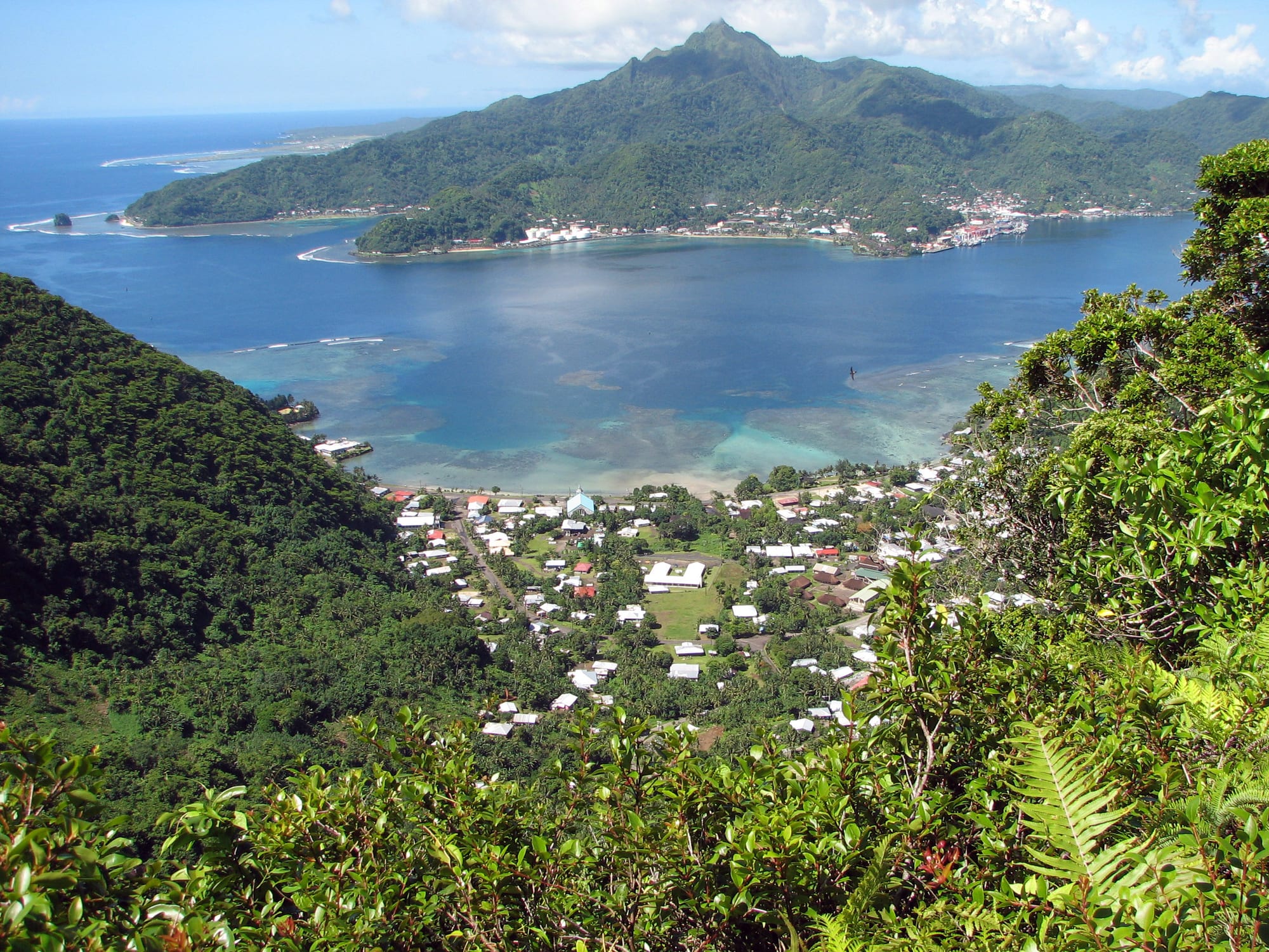
A deep blue harbour reaching inland between steep forested ridges, with villages and a wharf along its shores and a jagged peak beyond

American Samoa

Pago Pago

Pago Pago Harbor on Tutuila, seen from the ridge above the town. (Tavita Togia, National Park Service / Wikimedia Commons · Public domain)

The capital of American Samoa, at the head of a long, deep harbour on Tutuila that fills a breached volcanic crater. Chosen by the United States Navy as a coaling station at the turn of the twentieth century, it became a wartime base and then a tuna-canning port, and remains a working harbour town of village neighbourhoods below steep rainforest ridges.

Neighbourhoods

  • Pago Pago village
    • First-time visitors
    • Close to public transport

    The village at the very head of the harbour, where shipping offices, shops and small businesses are concentrated. The ridges rise steeply behind the houses, and buses along the harbour road link it to the rest of the island.

    Open in Maps
  • Fagatogo
    • Historic district
    • Markets
    • Government buildings

    The old commercial and administrative centre along the southern shore, with the market, the island's main bus station behind it, the port, the legislature, the courthouse, the police station, churches and the territorial museum within a few hundred yards of one another. It is the closest thing in the territory to a town centre.

    Open in Maps
  • Utulei
    • Beaches
    • Quiet and residential

    A village near the harbour entrance holding government offices, the governor's residence on the point above it, a performing arts auditorium, a hotel and a sheltered swimming beach. The road continues around to the batteries above the harbour mouth.

    Open in Maps
  • Atu'u and the northern shore
    • Local life
    • Industry and the port

    The villages of Atu'u, Leloaloa and Satala face the town across the water, and hold the tuna cannery, the fuel and power installations and the fishing fleet's berths. Rainmaker Mountain rises directly behind them.

    Open in Maps
  • Tafuna and Nu'uuli
    • Everyday shopping
    • Close to the airport

    The flat land about seven miles west of the harbour, where the airport, the territory's largest shops and much of the newer housing are. It is where most islanders now live and shop, and is very different in feel from the old harbour villages.

    Open in Maps

Things to do

The harbour and the town

  • Pago Pago Harborattraction

    A flooded volcanic crater breached by the sea, forming one of the deepest and best-sheltered harbours in the South Pacific and the reason the town exists.

    Open in Maps
  • Jean P. Haydon Museummuseum

    The territorial museum in Fagatogo, in a building put up as a naval commissary, with Samoan artefacts, canoes, tapa cloth and material on the naval and wartime years.

    Open in Maps
  • Fagatogo Marketmarket

    The covered market on the malae in Fagatogo, where growers and fishermen sell taro, breadfruit, bananas, coconuts and reef fish, busiest early in the morning.

    Open in Maps
  • Courthouse of American Samoalandmark

    The two-storey timber courthouse of about 1904 in Fagatogo, with verandas on three sides, built for the naval administration and among the oldest buildings standing in the territory.

    Open in Maps

Peaks, trails and the park

  • Rainmaker Mountainlandmark

    The trachyte mass on the harbour's eastern side, a national natural landmark, which catches the trade winds and makes this one of the wettest inhabited places in the Pacific.

    Open in Maps
  • Mount Alavaviewpoint

    The ridge above the northern shore, reached by trail, looking down the length of the harbour; a cable tramway once crossed the water to its summit.

    Open in Maps
  • Matafao Peakviewpoint

    The highest point on Tutuila, a steep volcanic plug west of the harbour and also a national natural landmark, with a rough climb to the top.

    Open in Maps
  • National Park of American Samoapark

    The national park on three islands, whose Tutuila section of rainforest, coast and reef begins over the ridge from the harbour, with an office in the town.

    Open in Maps

Beaches and wartime sites

  • Blunts Point Batterylandmark

    Six-inch naval guns emplaced above the harbour entrance during the Second World War, reached by a short, steep walk from the coast road.

    Open in Maps
  • Utulei Beachbeach

    A small, sheltered beach inside the harbour near the government offices, used for swimming, canoe training and village events.

    Open in Maps

Short trips from the town

  • Aunu'uattraction

    A small volcanic island off Tutuila's eastern end, reached by boat from Au'asi, with the territory's only taro paddy fields, a crater lake and a lake of red quicksand.

    Open in Maps
  • Vatia and the Pola Island cliffsattraction

    A village on the north coast over the ridge from the harbour, looking out at the sheer sea cliffs and seabird colonies of Pola Island inside the national park.

    Open in Maps

Seasonal events

  • Flag DayApril

    The territory's main celebration, marking the raising of the United States flag in 1900, with fautasi longboat races in the harbour, dancing, oratory and parades.

  • White SundayOctober

    Lotu Tamaiti, the Sunday when children lead church services in new white clothes and are given the best of the family meal afterwards.

Eat and drink

Long-standing places and food districts in Pago Pago. Hours, ratings and directions come from your maps app, always current.

Markets and harbour food

  • Fagatogo Marketmarket

    Taro, breadfruit, green bananas, coconuts, papaya and reef fish from village growers and fishermen, along with cooked food and drinking coconuts.

    Open in Maps
  • Harbour-front restaurants in Fagatogo and Utuleineighborhood

    The cluster of small restaurants and takeaways along the harbour road, where fresh tuna, sashimi and Samoan plates share the menus with Korean, Chinese and Filipino cooking brought by fishing and cannery families.

    Open in Maps
  • Roadside barbecue and takeawaysneighborhood

    Stands and small shops along the coast road selling grilled chicken and ribs, turkey tails, chop suey and rice in takeaway plates, particularly at the end of the working day.

    Open in Maps
  • Stores and food stalls at Tafuna and Nu'uulineighborhood

    The commercial strip near the airport has the territory's largest supermarkets, bakeries selling coconut buns, and a run of small restaurants and drive-in takeaways.

    Open in Maps

Experience Pago Pago

History

Samoan settlement around this harbour goes back thousands of years, and the villages on its shores were part of the chiefly world of eastern Tutuila long before Europeans arrived. The bay's shape, deep water and shelter made it valuable to nineteenth-century shipping, and it drew the attention of naval powers competing over the islands. The United States secured rights to use the harbour in 1878, and after the partition of the Samoan islands the high chiefs of Tutuila and Aunu'u ceded their islands in 1900. The harbour became Naval Station Tutuila, with a coaling station, a commissary and the buildings that still line Fagatogo.

Navy rule lasted half a century and shaped the town: the courthouse, the old commissary, the officers' housing and the roads around the bay date from it, and Samoans served in the Fita Fita Guard, a local naval unit. The harbour was also the setting of Somerset Maugham's story Rain, written after he sheltered here in 1916. In the Second World War Tutuila became a base, with marines, gun batteries above the harbour entrance and an airstrip built on the plain at Tafuna.

Administration passed to the Department of the Interior in 1951, and the navy's departure hit the town hard until tuna canneries opened on the northern shore in the 1950s and became the territory's economic engine. The harbour has since been a fishing port as much as a capital. An earthquake and tsunami in September 2009 struck the harbour villages, killing dozens of people in the territory and wrecking waterfront buildings, and warning systems and evacuation routes have been a priority ever since.

Culture & Customs

Pago Pago is not a city in the usual sense but a chain of villages around a harbour, and village institutions run local life. Each has its matai, its fono, its malae, or green, and one or more churches, and the pastor and the chiefs carry authority that the territorial government does not displace. Samoan is spoken everywhere, with English in offices and schools.

Church is the centre of the week. Congregational, Catholic, Methodist and Latter-day Saint congregations all have large buildings around the bay, choirs rehearse on weekday evenings, and Sunday morning empties the roads while the family meal after the service fills the afternoon. Most villages keep sa, when a bell or conch sounds and everyone stops for prayers.

The harbour is the natural stage for the territory's biggest occasions. Flag Day in April brings fautasi racing, the long crewed longboats that villages train for months, along with siva dancing, oratory and parades, and the water and the shore road fill with spectators. Fine mats and 'ava ceremonies mark formal events, and gifts and obligations move between families at weddings and funerals. Rugby and American football are followed intensely, and the territory sends players to college and professional teams in the United States far out of proportion to its size.

Daily Life

About fifteen thousand people live around the harbour, in a territory of about forty-seven thousand, and the balance has shifted west: the airport plain at Tafuna and Nu'uuli now hold the biggest shops, schools and much of the newer housing, while the harbour keeps the government offices, the port and the cannery. Families are large, households often span three generations, and many depend in part on money sent home from relatives in Hawaii, California, Washington and Utah.

Work means the tuna cannery on the northern shore, which is by far the largest private employer and ties the territory's fortunes to the fishing industry; the port, with its longline fleet and container berths; the territorial government, which employs a great many people; the hospital, schools and the community college; and shops and small businesses. A lower federal minimum wage, raised in steps, is a long-running argument about keeping canning viable.

The day starts before dawn with buses, cannery shifts and market deliveries, and ends early; shops shut in the evening and almost everything closes on Sunday. Persistent issues include the cost of imported food and fuel, power and water reliability, emigration of young people to the mainland, and rates of diabetes and heart disease linked to diet. The harbour's own condition — its water quality and the cannery's discharges — is a recurring local debate.

Food

Everyday cooking here is Samoan: taro, breadfruit, green bananas and yam as the starches, with palusami or lu'au, young taro leaves baked in coconut cream and sometimes wrapped around corned beef, as the dish most associated with the islands. Reef fish and tuna are eaten grilled, in soup, or as oka, raw cubes marinated in coconut cream with lime, onion and chilli. Sapasui, a Samoan chop suey of glass noodles and soy-seasoned meat, and koko alaisa, rice cooked with local cocoa, are family staples.

Sunday brings a family meal cooked in an umu of hot stones and eaten after church: pork or chicken, taro, palusami and often a whole fish, with sweet buns baked in coconut cream afterwards. Market food runs to taro and breadfruit, papaya, drinking coconuts and cooked packets of palusami.

The harbour's fishing industry shows on plates. Fresh tuna is cheap and good, served as steaks or sashimi, and Korean, Chinese and Filipino restaurants around the bay reflect the crews and cannery workers who settled here. Imported tinned corned beef, or pisupo, Spam, turkey tails and mutton flaps are cheap and widespread, and are part of the reason diet-related illness is a public health concern. 'Ava is drunk in ceremony rather than socially, while koko Samoa, made from local cocoa, and imported soft drinks are the everyday drinks.

Planning tools

Budget

There is little tourism infrastructure and therefore little to spend money on: a handful of hotels and guesthouses around the harbour and at Tafuna, a few restaurants, and a hire car. Almost everything is imported, so groceries and fuel cost more than on the US mainland, while village-grown food at the market and bus fares are cheap. Accommodation is the main outlay.

Daily Budget Midrange
USD 130–260 (hotel near the harbour, restaurant meals, a hire car, park and boat trips)
Daily Budget Shoestring
USD 60–110 (guesthouse, store and market food, aiga buses)

Note that shops and restaurants close on Sundays and buses barely run, so food and travel are best arranged the day before.

Best Time to Visit

May to October is drier, less humid and outside the cyclone season, and gives the best chance of clear days for hiking and boat trips. Flag Day in April is the liveliest time in the harbour. Humpback whales pass through the surrounding waters. Rain falls in every month, and the head of the harbour is wet even in the drier season.

Suggested Number of Days

Two or three days cover the harbour area and the nearest coast. Five to seven allow the rest of Tutuila and a flight out to the Manu'a Islands, which depends on a small aircraft and the weather. Sundays are very quiet, which is worth allowing for.

First Visit
2–3 days
With Surroundings
5–7 days

Transportation

Privately owned aiga buses — wooden-bodied buses painted by their owners — run along the coast roads without a fixed timetable, converging on the bus station behind the market in Fagatogo, and are cheap and sociable. A hire car is the practical option for anything beyond the harbour, since services thin out in the evening and on Sundays. Taxis wait at the market and the airport, and boats cross to Aunu'u from Au'asi.

Fares are paid in cash to the driver on the way out, and a wave from the roadside is how a bus is stopped.

Airport & Station Connections

Pago Pago International Airport is at Tafuna, about seven miles west of the harbour and some twenty to thirty minutes by road. Flights come from Honolulu and, on a short hop, from Apia in independent Samoa, with small aircraft on to the Manu'a Islands. Cruise ships and cargo vessels berth in the harbour itself, and the territory runs its own immigration, separate from the rest of the United States.

Confirm the territory's own entry requirements well before booking, and expect to show an onward ticket on arrival.

Walkability

The strip from Pago Pago village through Fagatogo to Utulei is flat and walkable, and the market, the museum and the government buildings are close together. Beyond that the coast road is narrow, with traffic and little shade, and the land rises abruptly, so trails climb steeply from the roadside. Heavy showers arrive without warning, and the heat and humidity slow everything down.

Safety

Crime is low and village social control is strong, and the harbour area is relaxed by day and quiet at night. The hazards are mainly natural: cyclones between about November and April, tsunami, for which the harbour is a known risk after the 2009 earthquake, strong currents outside the reef, and slippery, steep trails. Medical facilities are limited, and serious cases are flown to Hawaii.

Learn the tsunami warning signs and the routes to higher ground, swim inside the reef and ask locally about currents, stop and wait quietly if evening prayers begin while passing through a village, and carry insurance covering medical evacuation. Check current official travel advice before travelling.

Climate

Tropical, hot and humid all year, with temperatures typically in the low to upper 80s °F and little seasonal change. Rain is the defining feature: clouds pile against Rainmaker Mountain and the head of the harbour receives some of the heaviest rainfall of any inhabited place in the Pacific. The wetter months are roughly November to April, which is also the cyclone season, and May to October is a little drier.

Summer
December–February, the southern-hemisphere summer and the wet season: around 84–88°F, humid, with frequent heavy showers and cyclone risk
Winter
June–August: around 82–86°F, drier and breezier under the trade winds, the easiest months for walking

Local Customs

Life follows fa'a Samoa. Villages are governed by matai, the holders of family titles, and most observe sa, a short evening curfew for family prayers, during which anyone passing through is expected to stop and wait quietly. Sunday is for church and rest, and most shops close. Dress is modest away from a beach, shoes come off before entering a house or fale, and elders and matai are treated with deference. Land is almost all communally held, so beaches and trails usually belong to a village.

Ask before photographing people, houses or church services, sit rather than stand when others are seated in a fale, ask permission before using a village beach, and expect a small fee at some of them.

Common Payment Methods

The currency is the US dollar. Cash is used for buses, market stalls, small shops and village fees, and small notes are useful. Cards are accepted at the larger stores, hotels and car hire firms around the harbour and at Tafuna, and ATMs are on Tutuila only, so money is drawn before flying to the Manu'a Islands.