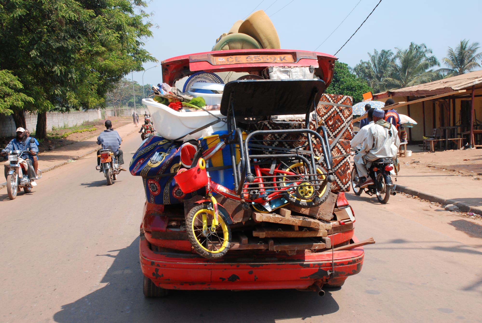
A red estate car piled high with furniture, bicycles and bundles on a sunlit road in Bertoua, motorbikes passing and roadside stalls behind

Douala, Yaoundé, the South & the East, Cameroon

Bertoua

A loaded vehicle and motorbike taxis on a main road through Bertoua. (Photokadaffi / Wikimedia Commons · CC BY-SA 4.0)

The capital of Cameroon's East Region, a road and administrative town on the edge of the country's great rainforest belt. Built up around a colonial post in Gbaya country, it lives on timber, transport, mining and government, and serves as the staging point for journeys deeper into the forest and towards the Central African Republic border.

Neighbourhoods

  • The administrative centre
    • First-time visitors
    • Hotels

    The higher ground holding the governor's offices, the prefecture, banks, the cathedral and most of the town's hotels, laid out along wide roads with a good deal of open space between the buildings.

    Open in Maps
  • The market and transport quarter
    • Markets
    • Local life
    • Close to public transport

    The busiest part of town, where the central market, the coach offices and the shared-taxi ranks sit close together. Traders, motorbike taxis and lorries bound for the forest roads crowd the streets from early morning.

    Open in Maps
  • The outer quarters
    • Quiet and residential
    • Local life

    Low-built residential neighbourhoods spreading along the roads towards Garoua-Boulaï, Batouri and Yaoundé, with small shops, churches, mosques and family compounds among mango trees and patches of cultivation.

    Open in Maps

Things to do

In the town

  • Bertoua central marketmarket

    The town's main market, selling forest produce, bushmeat substitutes such as smoked fish, cassava, plantain, cocoyam, palm oil, cloth and hardware brought up the road from Yaoundé.

    Open in Maps
  • The cathedral and mission quarterlandmark

    The Catholic cathedral and the mission buildings on the higher ground, seat of the archdiocese of Bertoua and its ecclesiastical province.

    Open in Maps

Getting around the region

  • Bertoua Airporttransit hub

    A small airport about 5 kilometres east of town, where airline flights began in 2017 and which was enlarged the following year.

    Open in Maps

Short trips from the town

  • Lom Pangar Damattraction

    A large reservoir dam on the Lom river, completed in 2017 to regulate the Sanaga and generate power, about 88 kilometres north of town.

    Open in Maps
  • Bélaboattraction

    A railway town about 55 kilometres west, a stop on the line between Yaoundé and Ngaoundéré, with the Sanaga-Yong chimpanzee rescue centre nearby.

    Open in Maps
  • Batouriattraction

    A town about 80 kilometres east, seat of the Kadey department, with a market, a Catholic mission and the road on towards the Central African Republic border.

    Open in Maps

Seasonal events

  • National Day20 May

    The national holiday, marked in the regional capital by a parade of schools, services and uniformed bodies past the governor's stand.

  • The dry seasonDecember to February

    The months when the forest roads are firm, logging and mining traffic is heaviest, and families return from Yaoundé and Douala for weddings, funerals and Christmas.

Eat and drink

Long-standing places and food districts in Bertoua. Hours, ratings and directions come from your maps app, always current.

Eastern kitchens

  • Forest-leaf stewsrestaurant

    Okok, made from shredded Gnetum vine leaves with peanuts and palm oil, and kpem, pounded cassava leaves with palm nut, served with cassava, cocoyam or plantain in the town's chop houses.

    Open in Maps
  • Grilled fish and soyarestaurant

    River fish grilled over charcoal with pepper sauce, and skewers of beef dusted with spiced peanut powder, cooked at braziers along the main streets in the evening.

    Open in Maps
  • Poulet DG and plantainrestaurant

    Chicken sautéed with fried plantain, carrots and beans — the standard restaurant dish across Cameroon and the usual choice for a sit-down meal here.

    Open in Maps

Markets and street food

  • Bertoua central marketmarket

    Produce from the forest and the surrounding farms — cassava, plantain, cocoyam, forest leaves, palm oil, groundnuts, smoked fish and, in season, wild mangoes and safou.

    Open in Maps
  • The market street stallsneighborhood

    Beignets with beans and maize porridge in the morning, roast maize and plantain through the day, and grilled meat near the coach offices at night.

    Open in Maps

Experience Bertoua

History

The country around Bertoua is the homeland of the Gbaya, who moved into the region from the north-east over the 18th and 19th centuries, along with the Kaka, Maka and other forest peoples, while Baka hunter-gatherer communities lived in the deeper forest. Long-distance trade in ivory, kola and slaves passed through, and the area lay at the meeting point of savanna and rainforest influences rather than under any single large state.

German Kamerun reached these forests late, and the administration set up posts to control the trade routes and impose taxes; the town grew from one such post on the high ground beside the road. Under French rule after the First World War it became a local administrative centre, with a mission, a school and a hospital, in a region that the colonial economy valued above all for rubber, timber and forced labour.

Independence in 1960 and later administrative reform made Bertoua the capital of the East Region, Cameroon's largest region by area and its emptiest. Timber concessions, the railway at Bélabo, the roads pushed south towards Yokadouma and east to the Central African Republic border, and mining in the region shaped its growth. Since the 2000s two things have changed it again: conflict across the border, which brought tens of thousands of refugees into the region, and the building of the Lom Pangar dam on the Lom river, which drew workers, traffic and money to the area.

Culture & Customs

Gbaya is the language most heard in the villages around the town, alongside Kaka, Maka and Pol, with French as the common tongue of the town itself and Fulfulde in the trading quarter. The East is the most ethnically mixed part of southern Cameroon, with families from the west and north settled here for work in timber, mining and administration, and the presence of refugees from across the border has added further communities.

The region is best known outside Cameroon for the Baka, forest hunter-gatherer communities whose music, and above all their polyphonic singing, has been recorded and studied widely. Baka families live along the forest roads south and east of Bertoua, and their relationship with settled farmers, logging companies and the protected forests is a live and difficult subject; visits are best arranged through organisations that work with the communities themselves.

Town life is Christian and Muslim together, with Catholic and Presbyterian churches and a mosque serving the northern and Hausa traders. Funerals, as elsewhere in Cameroon, are major weekend events, and the dry-season months bring weddings and family returns. Football is followed closely, and the local market is as much a social meeting point as a place of trade.

Daily Life

The 2005 census counted about 95,000 people in Bertoua's two communes, and the town, the largest in a region of forest, small settlements and very long roads, has grown quickly since. Government is the biggest employer — the regional services, the schools, the hospital — followed by transport, trade, timber and mining. International aid organisations have a strong presence because of the refugee camps and settlements in the region.

The day starts before sunrise with motorbike taxis, market deliveries and the coaches leaving for Yaoundé. The market is busiest in the morning, offices work through to the afternoon with a long lunch, and the evening belongs to the street grills and bars. Lorries loaded with logs pass through at all hours, bound for the sawmills and the rail terminal at Bélabo.

The town's problems are those of a remote regional capital: unreliable power and water, roads that deteriorate in the rains, few jobs for young people and a hospital serving an enormous area. It has grown quickly with arrivals from the countryside, from other regions and from across the border, which has stretched housing, schools and services.

Food

The everyday cooking here is forest food. Okok, the shredded leaves of the Gnetum vine simmered with ground peanuts and palm oil, and kpem, pounded cassava leaves cooked with palm nut, are eaten with cassava, cocoyam or plantain. Bâton de manioc, fermented cassava steamed in leaves, is the usual accompaniment, and groundnut sauces thickened with egusi seeds are common.

Fish comes from the Lom, the Kadey and the Sanaga, smoked in the villages and sold in bundles at the market or grilled whole over charcoal with pepper sauce. Poulet DG — chicken with fried plantain and vegetables — is the standard restaurant meal, and soya, spiced beef skewers grilled over wood, is the evening street snack, sold alongside roast maize and plantain.

The forest supplies seasonal foods that turn up in the market and rarely anywhere else: wild mango kernels ground to thicken soups, njansang seeds, safou, honey gathered in the forest and a range of leaves and tubers. Palm wine is tapped in the villages and drunk fresh, and bottled beer is the drink of the town's bars, where meat is grilled outside in the evening.

Planning tools

Budget

Bertoua is inexpensive to stay and eat in, with simple hotels aimed at officials, traders and aid workers. Costs rise sharply for anyone going further east or into the forest, where a four-wheel-drive vehicle, fuel, a driver, guides and park permits dominate the budget.

Daily Budget Midrange
USD 75–150 (better hotel, restaurant meals, a hired vehicle with driver)
Daily Budget Shoestring
USD 30–50 (basic hotel, chop houses and market food, shared taxis and motorbike taxis)

Carry enough CFA francs for the whole trip east; ATMs exist in Bertoua but are scarce and unreliable beyond it.

Best Time to Visit

December to February, the main dry season, is the practical window: the forest roads are firm and journeys east take hours rather than days. A shorter drier spell falls in July and August. From about September to November and again in April and May the rains turn the unsealed roads to mud.

Suggested Number of Days

The town itself needs little more than a day. Most visitors are here to go further — to the forest reserves, the mining towns or the border — and those journeys are long, so three to five days is realistic once travel time and the state of the roads are allowed for.

First Visit
1 day
With Surroundings
3–5 days

Transportation

Motorbike taxis are the everyday transport within town, with shared taxis on the main roads. Coaches and minibuses leave from offices near the market for Yaoundé, Batouri, Garoua-Boulaï and Yokadouma, and lorries carry passengers on the rougher forest routes. A hired four-wheel-drive vehicle is needed for anything off the main roads.

Start long road journeys early, since drivers avoid the forest roads after dark, and expect several police and gendarmerie checkpoints on every route.

Airport & Station Connections

Bertoua lies at the end of the sealed road east from Yaoundé, roughly eight hours by coach, and is also reached from Bélabo on the Yaoundé–Ngaoundéré railway. The small airport east of town has been served by airline flights since 2017, though there are few of them. Roads continue east to Batouri and Garoua-Boulaï and south to Yokadouma and the rainforest parks.

Walkability

The centre is spread out and the distances between the administrative quarter, the market and the coach offices are longer than they look on a map. Pavements are few, the sun is strong and the red dust or mud makes walking unpleasant in either season, so residents use motorbike taxis for almost every journey.

Safety

Bertoua itself is quiet, with petty theft around the market and the coach stations the usual risk. The concern in this region is the country east of it: the border area with the Central African Republic hosts large numbers of refugees and sees banditry and armed robbery on remote roads. Road accidents and breakdowns on forest tracks are the other real hazard.

Stay away from the Central African Republic border, travel the forest roads by day and in company, carry identification for checkpoints, and do not photograph officials, checkpoints or refugee sites. Check current official travel advice before travelling.

Climate

Hot and humid all year, on the northern edge of the equatorial forest at about 650 metres. Days generally reach 28–32°C and nights fall to around 19°C, with the seasons marked by rain rather than temperature.

Summer
wet and cloudy, with the heaviest rain arriving in September and October and daytime temperatures around 27–30°C
Winter
the dry season from December to February, hot, dusty and hazy with the Harmattan, around 30–33°C by day and cool at night

Local Customs

The East is Gbaya, Kaka, Maka and Baka country with a large population from other regions, and French is the common language. Greetings are formal and unhurried, and introductions through a local contact matter when visiting villages. Dress is modest, particularly around churches and mosques. Photographing people, and especially Baka communities, requires permission and is better arranged through a guide who knows the village.

Arrange any visit to a forest community through a recognised guide or association, agree the terms in advance, and ask before taking photographs.

Common Payment Methods

The currency is the Central African CFA franc (XAF), pegged to the euro. Cash is used for almost everything. Banks and ATMs are in the centre of Bertoua and can run out of notes; cards are accepted at very few places and not at all further east. Mobile money is widely used by residents.