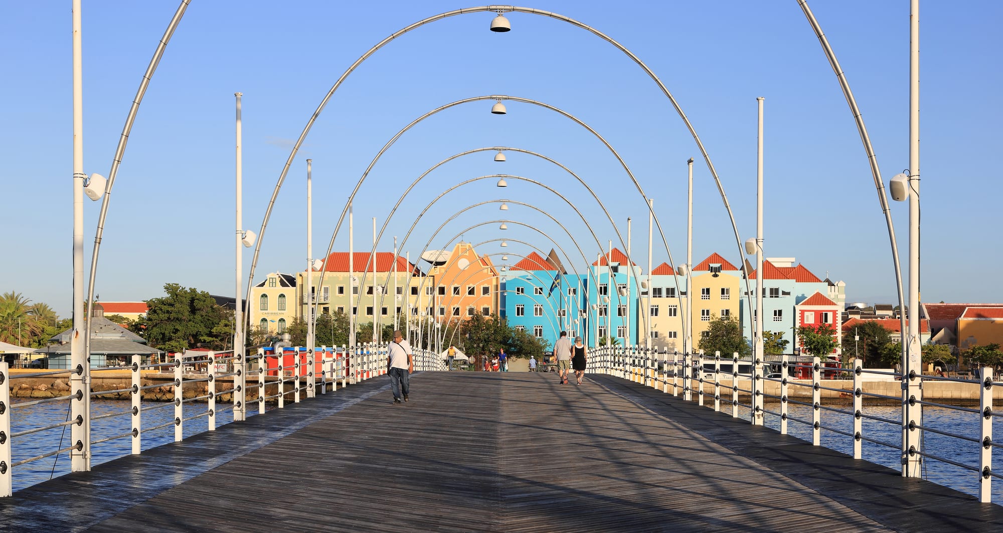
The wooden deck and white lamp arches of the Queen Emma Bridge leading to a row of pastel gabled houses in Otrobanda

Curaçao

Willemstad

Otrobanda seen from the Queen Emma pontoon bridge across the Sint Anna Bay, Willemstad. (Martin Falbisoner / Wikimedia Commons · CC BY-SA 4.0)

The capital of Curaçao, built by the Dutch West India Company around a deep natural harbour from 1634 and grown rich on trade, the slave trade and later oil. Its four historic quarters of colourful gabled houses, split by the Sint Anna Bay and joined by a swinging pontoon bridge, are a UNESCO World Heritage Site, and most of the island's people live in the city.

Neighbourhoods

  • Punda
    • First-time visitors
    • Historic district
    • Shopping

    The original walled town on the eastern point of the harbour mouth, founded in 1634 — its name comes from the Dutch 'de punt', the point. The pastel merchant houses of the Handelskade, Fort Amsterdam, the synagogue and the floating market are here, among narrow shopping streets that empty out on Sundays.

    Open in Maps
  • Otrobanda
    • Museums
    • Local life
    • Close to public transport

    'The other side' of the Sint Anna Bay, founded in 1707 and long the cultural heart of the city. Restored houses hold the Kurá Hulanda Museum and the Curaçao Museum, the Rif Fort guards the harbour entrance, Breedestraat is lined with everyday shops, and street-art murals cover many walls.

    Open in Maps
  • Scharloo
    • Architecture
    • Quiet and residential

    A former plantation across the small Waaigat harbour that became the wealthiest part of town after Jewish merchants began building villas there from 1870. Scharlooweg has the grandest of them, including the ornate Bolo di Batrei, the 'wedding cake' house; many villas now serve as offices.

    Open in Maps
  • Pietermaai
    • Nightlife
    • Best for food
    • Historic district

    A seafront suburb founded in 1675 just east of Punda, badly damaged by the hurricane of 1877 and run-down by the 1970s. Renewal has turned it into the city's fashionable quarter, known for restored houses, restaurants, bars and jazz.

    Open in Maps
  • Mambo Beach and the south-east coast
    • Beaches
    • Nightlife

    A string of developed beaches east of the centre — Mambo Beach, Seaquarium Beach and Jan Thiel among them — with beach bars and restaurants, and Mambo Beach the place locals and visitors go for nights out.

    Open in Maps
  • Spaanse Water
    • Quiet and residential
    • Boating

    A sheltered natural harbour and lagoon east of the city, full of small bays and islets, with the Tafelberg above it and the resort area of Nieuwpoort on its shores.

    Open in Maps

Things to do

Famous landmarks

  • Queen Emma Bridgelandmark

    The 'Swinging Old Lady', a pontoon bridge of 1888 between Punda and Otrobanda that swings aside on its hinge to let ships through, while free ferries carry pedestrians across; it has been for pedestrians only since 1974.

    Open in Maps
  • Queen Juliana Bridgelandmark

    The four-lane road bridge arching 56 metres above the Sint Anna Bay so that ships can pass beneath; part of it collapsed during construction in 1967, killing fifteen workers, and the present bridge opened in 1974.

    Open in Maps
  • Fort Amsterdamlandmark

    The fort built by the Dutch West India Company in 1634 at the harbour mouth, once the company's headquarters and now the seat of the government and governor of Curaçao.

    Open in Maps
  • Curaçao Synagoguelandmark

    Mikvé Israel-Emanuel, known as the Snoa, completed in 1732 for a congregation established in 1651 — the oldest surviving synagogue in the Americas, with a sand-covered floor and a Jewish history museum attached.

    Open in Maps
  • Fort Nassauviewpoint

    A fort of 1796 on a 68-metre hill above the harbour, renamed Fort George under British rule and later used as the control tower for the Queen Emma Bridge; it has housed a restaurant since 1959.

    Open in Maps
  • Basilica of St. Annelandmark

    A church in Otrobanda built between 1734 and 1752, now a minor basilica and co-cathedral and one of the world's smallest basilica churches.

    Open in Maps
  • Queen of the Most Holy Rosary Cathedrallandmark

    Pietermaai's ochre-and-white cathedral of 1870, the seat of the diocese, with a bright white interior full of statues.

    Open in Maps
  • Rif Fortlandmark

    A 19th-century fort with coral walls 1.5 metres thick at the Otrobanda side of the harbour entrance, now filled with restaurants, bars and shops.

    Open in Maps

Museums

  • Kurá Hulanda Museummuseum

    An anthropological museum opened in 1999 in restored buildings on the Otrobanda quay where slave ships once landed, telling the story of the Atlantic slave trade from capture in Africa to the Americas.

    Open in Maps
  • Curaçao Museummuseum

    The island's oldest surviving museum, opened in 1948 in a former military hospital in Otrobanda, with paintings, furniture, glass and textiles and exhibitions of local artists.

    Open in Maps
  • Maritime Museummuseum

    In a building of 1729 in Scharloo, an overview of some 500 years of Curaçao's maritime history through charts, ship models and navigation instruments.

    Open in Maps

Markets

  • Floating marketmarket

    A line of boats moored along the Punda waterfront, long known for selling fresh fish and fruit brought over from Venezuela.

    Open in Maps

Beaches and the coast

  • Seaquarium Beachbeach

    A public beach south of the centre, named after the nearby sea aquarium, with an entry fee and a cluster of bars, clubs and restaurants.

    Open in Maps
  • Jan Thiel Lagoonpark

    Salt lagoons and woodland on the south coast beside the city, recognised as an Important Bird Area for its breeding colonies of terns.

    Open in Maps
  • Spaanse Waterattraction

    A large lagoon harbour east of the city, with sheltered bays and small islands much used for boating.

    Open in Maps

Short trips from the city

  • Hato Cavesattraction

    Show caves in coral limestone, open to the public since 1991, with stalactites, pools and a colony of fruit bats.

    Open in Maps
  • Klein Curaçaoattraction

    An uninhabited islet of 1.7 square kilometres lying about 10 km south-east of Curaçao, reached by boat, with an old lighthouse and coral reefs well known for diving.

    Open in Maps
  • Christoffelparkpark

    The national park at the north-western end of the island around the Christoffelberg, the highest point, with former plantations and trails to explore by car, bike, horse or on foot.

    Open in Maps

Seasonal events

  • Tumba Festivalearly February

    A week-long contest of tumba, the African-derived rhythm that has been the official Carnival music since 1971, whose winner is crowned Rei or Reina di Tumba.

  • Carnival and the Gran MarchaJanuary to late February or early March

    About two months of elections, children's parades and parties that build to the Gran Marcha, a 6.5-kilometre grand parade held since 1971, and end with the farewell parade, the Marcha di Despedida.

  • SeúEaster Monday

    The harvest festival, with parades to seú music through the west of the island and the streets of Otrobanda.

Eat and drink

Long-standing places and food districts in Willemstad. Hours, ratings and directions come from your maps app, always current.

Willemstad classics

  • Plasa Bieumarket

    A lunchtime favourite of local people working in Punda, where about five small restaurants serve krioyo (local), Chinese and Jamaican food.

    Open in Maps
  • Landhuis Chobolobocafe

    The country house where the island's Curaçao liqueur, made from the dried peel of the bitter laraha orange, has been distilled since 1947.

    Open in Maps

Food districts

  • Pietermaaineighborhood

    Restored seafront houses now holding many of the city's restaurants, cafés and jazz bars.

    Open in Maps
  • Otrobanda's waterfront and Rif Fortneighborhood

    Restaurants and fast-food spots along the Sint Anna Bay and inside the walls of the Rif Fort, facing the Punda waterfront.

    Open in Maps
  • Snacksrestaurant

    Small bar-restaurants all over the city, often doubling as convenience stores, that serve cheap Chinese food late into the evening to a mostly local crowd.

    Open in Maps

Experience Willemstad

History

The Dutch West India Company took Curaçao from Spain in 1634 and built a walled town on the eastern point of the harbour mouth, which became Punda, from the Dutch "de punt". Fort Amsterdam, raised that same year, served as the company's headquarters. The deep natural harbour of the Schottegat made the town a trading hub, and it soon became one of the major centres of the Atlantic slave trade, which drove rapid growth. Sephardic Jews from Amsterdam and Recife settled as merchants, and the name Willemstad, honouring a Prince of Orange, is first recorded in 1680.

The walled town outgrew itself. Pietermaai was laid out beyond the walls in 1675, Otrobanda — "the other side" — across the bay in 1707, and Scharloo followed on a former company plantation. By 1818 Willemstad and its suburbs held about 9,500 people. The walls came down after 1861, the Queen Emma pontoon bridge joined the two sides of the bay in 1888, and a hurricane in 1877 swept away much of Pietermaai. In 1915 Royal Dutch Shell built its refinery on the harbour, and the oil boom created new neighbourhoods, including company housing at Julianadorp and Emmastad.

On 30 May 1969 a strike at a refinery subcontractor became the riots of Trinta di Mei; two people died, part of the historic centre burned and Dutch marines were sent in. Shell left in the mid-1980s and the refinery passed to the government, which leased it to Venezuela's PDVSA until refining stopped at the end of 2019. In 1997 the historic centre was listed as a UNESCO World Heritage Site, and a large programme of restoration has since revived its old quarters.

Culture & Customs

Willemstad's culture is Afro-Caribbean at its core and spoken in Papiamentu, but layered with Dutch, Sephardic Jewish, Latin American and other influences that show in its churches, synagogues and streets. Otrobanda was long the cultural centre of the city, and its walls are now covered in murals from Kaya Kaya, a street-art festival held in the neighbourhood.

Music and parades mark the year. Carnival has been a festival for the whole population since 1961 and runs for about two months, beginning with the election of the Prince and Pancho and the queen, moving through the Tumba Festival, which crowns a king or queen of tumba, and peaking in the 6.5-kilometre Gran Marcha. On Easter Monday the Seú harvest festival parades through Otrobanda to its own music. Tambú, the drum-and-chant form once restricted by the church and the authorities, is part of the same inheritance.

Sport is a point of pride. Willemstad has produced a long line of Major League Baseball players, among them Andruw Jones, Kenley Jansen and Jurickson Profar, and its Little League teams have won world titles, the first in 2004. In 2025 Curaçao became the smallest nation ever to qualify for a football World Cup, and the city followed the team to its first World Cup point in 2026.

Daily Life

Willemstad held about 137,000 people in 2011, around nine-tenths of the island's population. Over the years the city has spread to fill the whole area around the Schottegat harbour, from the old quarters to residential districts such as Brievengat in the north, Santa Maria near the airport, and Buena Vista, built for refinery workers.

The harbour remains the economic centre: Willemstad is one of the largest oil-handling ports in the Caribbean, with ship repair and the idle refinery whose future is still being decided. Banks and international companies are drawn by the island's tax rules, the Central Bank of Curaçao and Sint Maarten and the Dutch Caribbean Securities Exchange are based here, and the University of Curaçao and medical schools bring students. Tourism, with cruise ships docking beside Otrobanda and divers heading for the reefs, is a major industry.

Daily life is bilingual or trilingual and largely car-dependent once beyond the centre. Punda's shopping streets are busy on weekdays and quiet on Sundays, office workers queue for lunch at Plasa Bieu, and evenings move to the bars of Pietermaai and the beach clubs east of town. The cost of living, unemployment and the arrival of Venezuelans fleeing the crisis next door are recurring concerns.

Food

Willemstad's kitchens serve Curaçaoan home cooking with Dutch, Latin and African threads. The signature dish is keshi yena, a hollowed round of Edam or Gouda cheese stuffed with spiced meat, often chicken, with olives and raisins, then baked or steamed. Stobá, a stew of goat, beef or papaya, is an everyday staple, as are guiambo, a slippery okra-and-seafood soup, kadushi, a soup made from cactus, and sopi mondongo, an intestine soup. Funchi, a cornmeal paste close to polenta, comes with most plates, alongside salt fish, fresh fish or goat.

Pastechi, fried pastry turnovers filled with cheese, tuna, chicken or minced meat, are the usual breakfast and snack. At lunchtime the small restaurants of Plasa Bieu in Punda serve krioyo, Chinese and Jamaican plates to locals working nearby, and the boats of the floating market on the Punda waterfront have long sold fish and fruit. The island's many "snacks", small bar-restaurants that double as convenience stores, serve cheap Chinese food late into the evening, and Indonesian dishes such as satay with peanut sauce arrived by way of Suriname.

The city's own drink is Curaçao liqueur, flavoured with the dried peel of the laraha, a bitter orange descended from the Seville oranges brought by the Spanish; the Senior family began selling it from their pharmacy in 1896 and has distilled it at Landhuis Chobolobo since 1947. Amstel Bright, a pale lager served with a wedge of lime, is a popular beer.

Planning tools

Budget

Willemstad is mid-priced by Caribbean standards. Restaurants and shops in Punda, aimed at cruise passengers, are the dearest; lunch at Plasa Bieu, the snack bars and supermarkets keep costs down. Rooms range from guesthouses in the old quarters to resorts along the coast, and a hire car is the main extra for anyone planning to see the rest of the island.

Daily Budget Midrange
USD 150–320 (hotel, restaurants, museum tickets, car hire or a dive)
Daily Budget Shoestring
USD 55–95 (guesthouse or apartment, market lunches and snack-bar food, buses)

Walking the historic quarters, crossing the pontoon bridge and the street art of Otrobanda cost nothing; keep small change for buses, which take cash only.

Best Time to Visit

Any time of year works. December to April is the busiest and dearest stretch, with Carnival filling the streets from January to February or early March. May to November is quieter, and the brief showers of the rainy season fall mostly late in the year.

Suggested Number of Days

Two or three days cover the historic quarters and museums. Most visitors use the city as a base for the whole island, so a week allows time for beaches, diving and the national parks; cruise passengers usually see the city in a single day.

First Visit
2–3 days
With Surroundings
5–7 days

Transportation

The four historic quarters are close together and best covered on foot, with the pontoon bridge or free ferries linking Punda and Otrobanda. ABC buses run lines around the city and the island from two stations, Punda and Otrobanda, but departures can be an hour or two apart. Shared minivans marked BUS list their stops on a card in the windscreen, taxis are marked TX, and Click is the local ride-hailing app. A hire car is the practical way to reach the beaches.

Agree a taxi fare before setting off, and leave time to walk between the two bus stations, which serve different parts of the island.

Airport & Station Connections

Curaçao International Airport, also called Hato, lies on the north coast about 12 km from the city, with flights from Europe, the Americas and the Caribbean; taxis, hire cars and infrequent buses run into town. Cruise ships dock at the Mega Pier on the Otrobanda side or the cruise terminal, a short walk from the centre. There are no ferries to other islands.

Walkability

The historic centre is compact and walkable: Punda's streets, the Handelskade and Otrobanda's lanes are a few minutes apart across the pontoon bridge, and Scharloo and Pietermaai are just beyond. Shade and the heat are the main limits. Beyond the old quarters the city spreads around the Schottegat harbour along busy roads built for cars.

Safety

Curaçao is one of the safer Caribbean islands, with petty theft from cars, hotel rooms, and beaches the main concern, and some violent crime and drug activity in parts of Willemstad, especially Otrobanda and the areas away from the tourist centre after dark. Car break-ins are a recurring problem, and valuables are best never left in a car.

Leave nothing in a parked car, and take normal care in Otrobanda after dark. Check current official travel advice before travelling.

Climate

A hot semi-arid climate, sunny and breezy all year, cooled by the steady trade wind from the east. Rain is light and comes mostly in short showers, many of them at night, late in the year. The island lies south of the main hurricane belt.

Summer
hot, dry and windy — across the island temperatures run around 28–32°C
Winter
much the same, with the rainy season's brief showers from October to December and days around 28–32°C across the island

Local Customs

Papiamentu is the everyday language, with Dutch, English and Spanish widely spoken. 'Danki' means thanks, and 'dushi' is the all-purpose word for anything good, from a view to a meal. On Sundays most businesses other than restaurants close.

The synagogue, the basilica and the cathedral are working places of worship as well as sights.

Common Payment Methods

The currency is the Caribbean guilder, pegged to the US dollar, which is widely accepted. Visa and Mastercard work almost everywhere, American Express less so, and ATMs are common but charge high fees. Cash is needed for buses and small stalls.