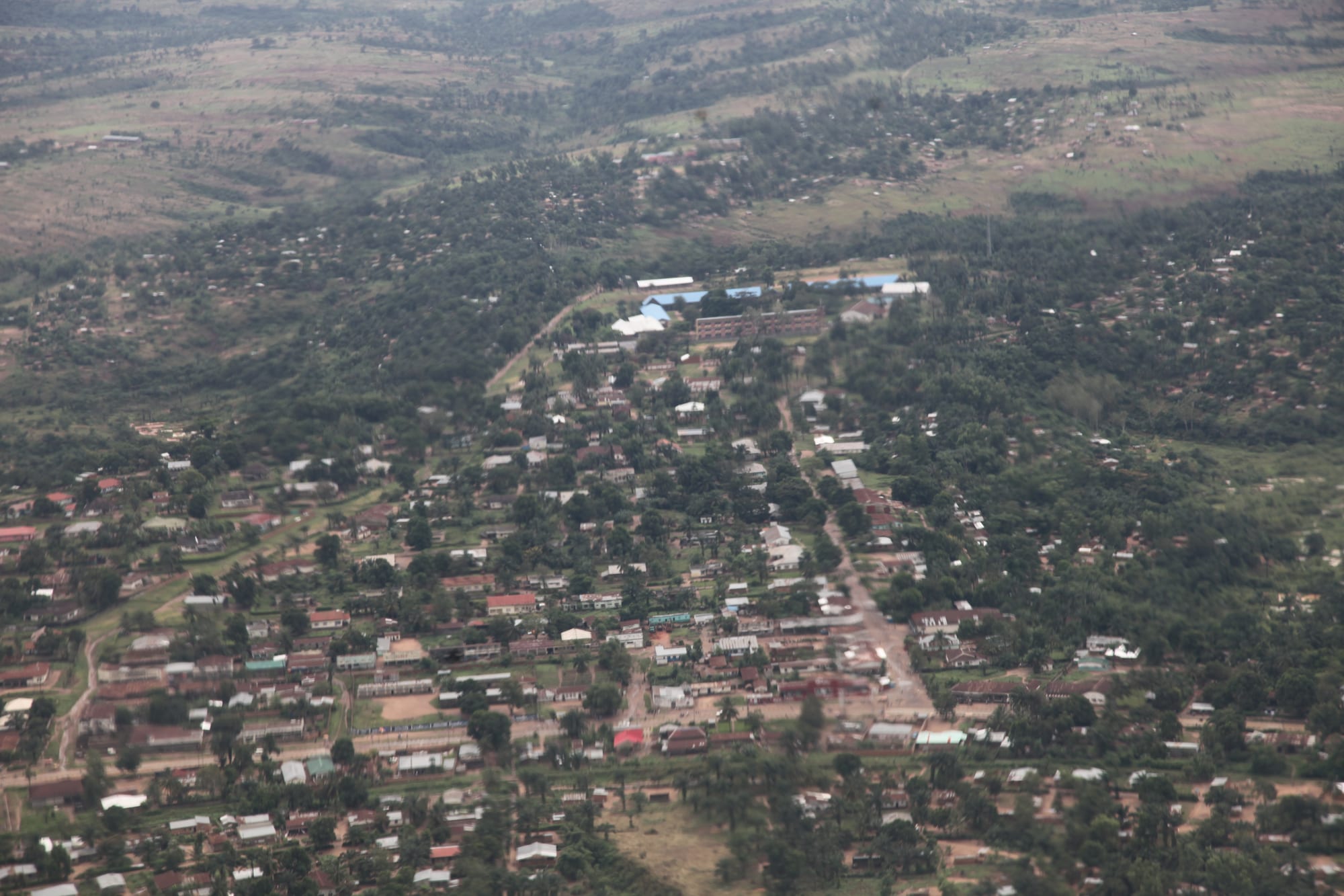
Aerial view of a low-rise town of small roofs and red earth roads among trees, with green hills beyond

The Kasaï, Democratic Republic of the Congo

Kananga

Kananga from the air, spread over the low hills of Kasaï-Central. (MONUSCO/Myriam Asmani / Wikimedia Commons · CC BY-SA 2.0)

The capital of Kasaï-Central, spread over low hills above the Lulua river in the savanna of the south-central DR Congo. Founded as a colonial station in the 1880s, later Luluabourg, and renamed in 1966, it grew as a railway and administrative town and is now one of the country's larger cities, a junction of road, rail and air routes. This page is written to explain the city, not to encourage travel.

Neighbourhoods

  • The centre
    • First-time visitors
    • Commerce
    • Administration

    The old colonial core, laid out on wide avenues with the provincial offices, banks, the cathedral, the main market and most of the town's few hotels. Shops and stalls line the main streets and the traffic is mostly motorbike taxis.

    Open in Maps
  • Katoka
    • Local life
    • Markets

    A large commune west of the centre, densely built with compounds of small houses, churches, schools and street markets. It is residential rather than commercial, with trade concentrated along the main roads.

    Open in Maps
  • Lukonga
    • Local life
    • Quiet and residential

    A commune on the western edge of the town, where housing gives way to fields and the savanna begins. Farming plots, brickworks and water points sit among the compounds.

    Open in Maps
  • Ndesha and Nganza
    • Local life
    • Markets

    The outer communes to the north and south-east, among the fastest-growing parts of the town and among the worst served by water and electricity. Both were badly affected by the violence of 2016 and 2017 and received many displaced families.

    Open in Maps

Things to do

Getting around and landmarks

  • Kananga Airporttransit hub

    The airport a few kilometres from the centre, served by the domestic flights that bring almost every visitor to the town.

    Open in Maps

The river and green space

  • Lulua Riverattraction

    The river below the town, a tributary of the Kasai, used for washing, fishing and sand digging, with gallery forest along its banks.

    Open in Maps

Short trips from the city

  • The Fwa riverattraction

    A savanna river east of the town in the neighbouring Kasaï-Oriental, a tributary of the Lubi, known for a community of fish found nowhere else.

    Open in Maps
  • Dembaattraction

    A small territorial centre north of the town on the road towards the Kasai, in farming country that supplies Kananga's markets.

    Open in Maps

Eat and drink

Long-standing places and food districts in Kananga. Hours, ratings and directions come from your maps app, always current.

Kasaï classics

  • Bidia with saucerestaurant

    The regional staple, a stiff dough of maize and cassava flour eaten with the right hand alongside a stew of greens, groundnut sauce, dried fish or goat.

    Open in Maps
  • Brochettes and grilled goatrestaurant

    Skewers of meat grilled over charcoal at street braziers in the evening, sold beside bars along the main avenues.

    Open in Maps

Markets

  • Kananga central marketmarket

    The town's main market, where traders sell cassava flour, maize, groundnuts, dried fish, palm oil, vegetables, charcoal and imported goods, busiest early in the morning.

    Open in Maps

Experience Kananga

History

The German explorer Hermann Wissmann, travelling for King Leopold II, set up a station on the Lulua river in the 1880s and called it Malandji; when the railway was built on the far bank the station moved, and the new town took the name Luluabourg from its Lulua railway station. The site sat between the Luba and Lulua peoples in open savanna, at a crossing point on routes running east towards Katanga and north to the Kasai. In 1895 Tetela soldiers of the Free State's army mutinied here, in a revolt that took years to put down.

Under Belgian rule Luluabourg became an administrative and railway town, a stop on the line linking the Katanga mines with the river port of Ilebo, from where barges carried copper down the Kasai towards the capital. Missions founded schools and a cathedral, and the town became the main market for the farming country around it. A constitution drafted here in 1964 was known by the town's name.

Independence brought conflict between Luba and Lulua communities and the upheaval of the South Kasai secession to the east, and many families moved between the two areas. The town was renamed Kananga in 1966 during Mobutu's campaign to replace colonial names, and it has grown very large since, without the services to match. In 2016 the killing of a customary chief, Kamuina Nsapu, set off an uprising in Kasaï Central; the violence and the military response that followed reached the town itself and displaced great numbers of people, and two United Nations investigators were murdered in the province in 2017. Recovery has been slow, and Kananga remains the administrative centre of a province still marked by those years.

Culture & Customs

Kananga is a Tshiluba-speaking city, home to Lulua and Luba-Kasai people whose relations have shaped the region's politics since independence. French is the language of school and administration, Lingala arrives with soldiers, traders and music from the capital, and Tshiluba carries ordinary life. Kasaïans have a reputation across the country for schooling, commerce and political argument, and many families here have relatives in Kinshasa or Lubumbashi.

Customary authority survives alongside the state. Chiefs are consulted over land, marriage and disputes, and their succession is taken seriously — one reason a contested chieftaincy could set off the violence of 2016. Extended families are large and obligations run wide: school fees, funerals and weddings are shared costs, and a funeral can fill a street for days.

Church life is strong, with Catholic and Protestant missions of long standing, Kimbanguist congregations and a great number of revival churches whose choirs rehearse in the evenings. Music in the Kasaï centres on mutuashi, the Luba dance rhythm carried to national audiences by the singer Tshala Muana, though rumba and ndombolo from Kinshasa dominate the bars. Craft traditions in the wider region — raffia weaving, carving and beadwork — reach the town's markets from the Kuba and Songye country to the north and east.

Daily Life

Kananga is one of the larger cities in the country, with an estimated population of about 1,524,000 in 2021, which makes it the fourth most populous urban area in the DR Congo; no recent census exists and estimates vary. It covers a lot of ground for its size: low compounds, red earth streets and patches of cultivation, with only the centre built up and surfaced.

Work is mostly informal. Trading, transport, small workshops, construction and farming on the edges of town support most households, alongside the provincial administration, the churches and a large presence of aid organisations. The railway and the improved road west bring goods in, but freight is slow and expensive, which keeps prices high. Electricity is intermittent and much of the town relies on generators, solar panels and charcoal, and water comes from standpipes, wells and the river.

The day starts at first light with the markets and the motorbike taxis, and much business is done before the heat of the afternoon. Evenings belong to churches, bars and the grills along the avenues. The aftermath of the Kamuina Nsapu years — displaced families, damaged villages, orphans and a strained health system — still shapes conversation, along with school fees, the price of maize flour and the exchange rate.

Food

The Kasaï plate begins with bidia, a stiff dough of maize and cassava flour, eaten with the right hand and dipped into a sauce. Pondu, cassava leaves pounded and stewed with palm oil and onion, is the standard green, and sauces are built on groundnuts, palm oil, okra, aubergine and plenty of pili-pili chilli.

Protein is goat, chicken, beans and fish — smoked or dried rather than fresh, since the town is far from any large river fishery, though the Lulua supplies some. Caterpillars gathered in season are fried with onion and sold by the cup, and bushmeat comes in from the forests to the north. Sweet potatoes, maize, groundnuts and beans from the surrounding farmland fill the market, and mangoes, bananas, avocados and pineapples are cheap in season.

Eating out means small local kitchens serving a plate of bidia and sauce, or the evening braziers where goat and skewered meat are grilled beside the bars. Bottled lager arrives by road and rail from Kinshasa and Lubumbashi; palm wine and home-brewed maize or sorghum beer are the local drinks, and a strong home-distilled spirit circulates informally. Sugary tea or instant coffee with bread or fried dough starts the day.

Planning tools

Budget

There is no visitor circuit here and no budget travel network. Hotels are basic to mid-range and priced in US dollars, often high for what they offer because aid workers, officials and traders are the main guests. Food and local transport cost very little; the flight from Kinshasa is the real expense.

Daily Budget Midrange
USD 120–250 (hotel in Kananga, driver, meals), before flights
Daily Budget Shoestring
USD 40–80 (simple guesthouse, market food, motorbike taxis) — there is no budget travel circuit here

Bring all the US dollars needed in clean, new notes, plus Congolese francs for markets and motorbike taxis; card payments and cash machines cannot be relied on.

Best Time to Visit

June to August, the drier months, when the laterite roads are passable and the sky clears. The rains from September to May turn tracks to mud and can cut outlying areas off for days. In practice local security and health conditions matter more than the season.

Suggested Number of Days

A day or two covers the town, which is large in area but short on formal sights. Three or four suit anyone travelling out to the lakes and farming country east and north of it. Road conditions and flight schedules decide the real length of a stay.

First Visit
1–2 days
With Surroundings
3–4 days

Transportation

Motorbike taxis are the main way to move around, along with shared minibuses on the main roads; only a few avenues are surfaced and the rest are red earth that turns to mud in the rains. The railway towards Ilebo and Katanga runs irregularly. Visitors normally hire a vehicle with a driver through their hotel or a local organisation.

Agree fares in advance, allow far more time than distances suggest on unpaved roads, and do not travel between towns after dark.

Airport & Station Connections

Kananga Airport, a few kilometres from the centre, handles the domestic flights that bring nearly everyone who arrives. The road from Kinshasa through Tshikapa has been improved in parts but remains a long, hard journey, and the railway from Katanga to Ilebo passes through the town on an irregular schedule.

Walkability

The centre can be walked, with the market, the main avenues and the provincial offices close together, though pavements are intermittent and the sun is strong. The town sprawls over a wide area of low hills, so anything beyond the centre means a motorbike taxi, and unpaved streets are dusty in the dry season and muddy in the rains.

Safety

The Kasaï lies far from the war in the east, but the region has its own recent history of violence: the Kamuina Nsapu uprising of 2016 to 2019 and the military response killed thousands and displaced many more, and tensions between communities have not fully faded. Health services are weak, disease outbreaks recur, petty theft is common in crowded places, and roads are poor.

Most governments advise caution throughout the DR Congo; visits here should be arranged with a trusted local contact or organisation, and roads avoided after dark. Carry documents for checkpoints, take malaria precautions seriously and ask locally before travelling outside the town. Check current official travel advice before travelling.

Climate

A hot, humid savanna climate on a plateau, slightly cooler than the central river basin. Rain falls from about September to May, with a shorter, drier and cooler spell from June to August, when nights can feel genuinely cool.

Summer
rainy season (September–May): hot and humid, roughly 20–31°C, with heavy afternoon storms
Winter
dry season (June–August): warm days and cooler nights, roughly 16–30°C

Local Customs

Tshiluba is the everyday language and French the language of offices and schools; a greeting in Tshiluba is well received. Greetings are unhurried and elders are addressed first. Customary chiefs still matter in questions of land and family, churches are central to the week, and funerals and weddings draw very large gatherings. Dress is modest and neat.

Tipping is not expected; ask before photographing people, markets or churches, and never photograph soldiers, police, the airport or government buildings.

Common Payment Methods

The Congolese franc is used for markets, transport and small purchases, while hotels and anything substantial are priced in US dollars. Bring new, undamaged dollar notes, as worn or older bills are refused. Cards are almost never accepted, cash machines are unreliable, and residents use mobile money widely.