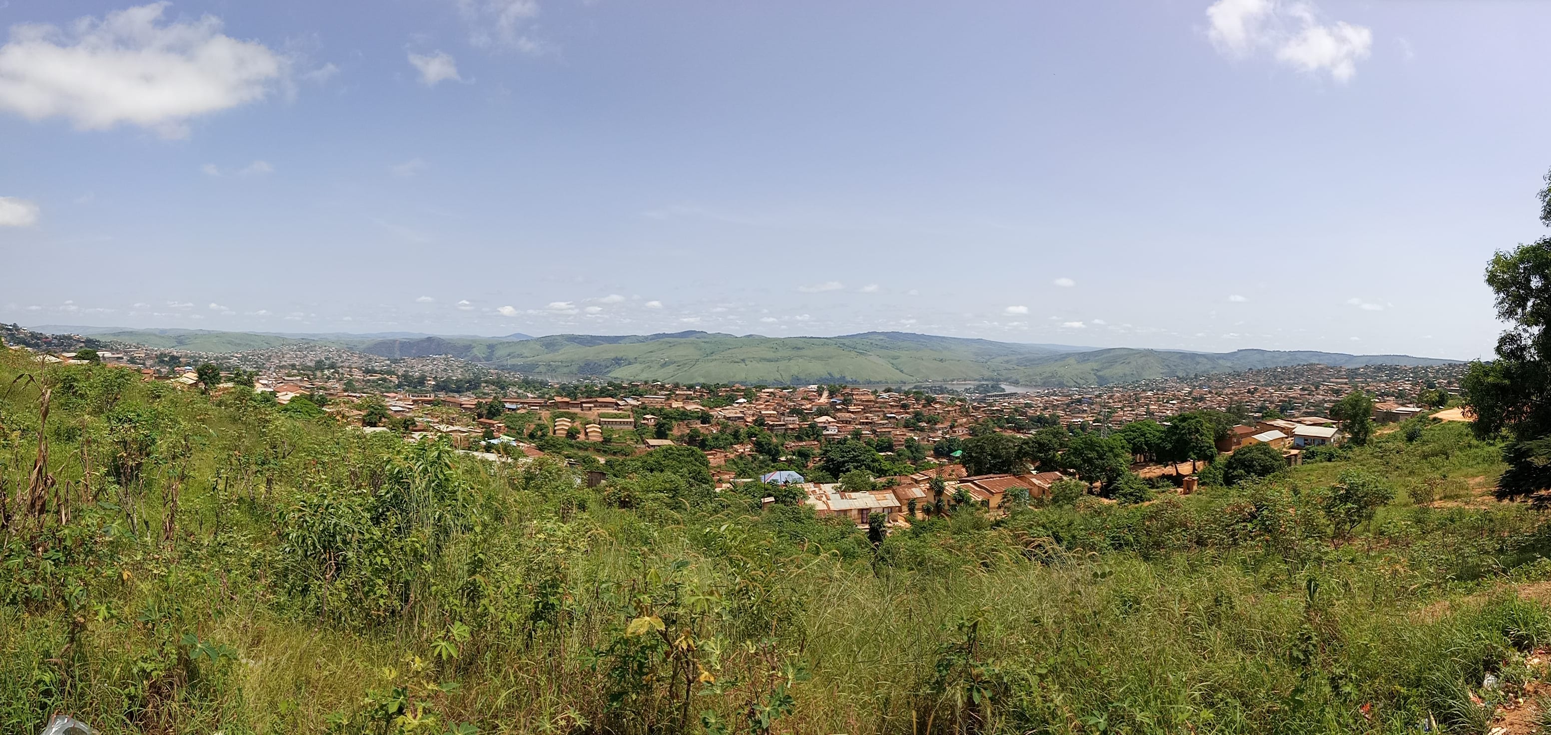
A town of low red and grey roofs filling a valley between green hills, seen from a grassy slope under a blue sky

Kinshasa & the West, Democratic Republic of the Congo

Matadi

Matadi spread across the hills above the lower Congo River, seen from Kintuadi. (Shaloom Yave / Wikimedia Commons · CC BY-SA 4.0)

The DR Congo's main seaport, built on steep rock above the lower Congo River in Kongo Central, about 150 kilometres from the Atlantic and as far upstream as ocean ships can reach. It grew from a river station of 1879 into the terminus of the railway to Kinshasa, and a suspension bridge has crossed the gorge here since 1983. This page is written to explain the city, not to encourage travel.

Neighbourhoods

  • Ville and the port
    • First-time visitors
    • The waterfront
    • Commerce

    The old lower town on the river, where the quays, customs offices, banks, trading houses and the railway station stand within a few streets of each other. Lorries queue for containers along the waterfront, and the streets climb sharply away from the water.

    Open in Maps
  • Nzanza
    • Local life
    • Markets

    One of the town's three communes, spread over the slopes above the centre, largely residential with small shops, churches and a busy street market. The climb between levels is steep enough that most journeys are made by shared taxi or motorbike.

    Open in Maps
  • Mvuzi
    • Quiet and residential
    • Views

    The upper commune inland from the river, with newer housing running up the hills, schools and the road out towards the bridge. Views back over the roofs of the lower town and the gorge open from many of the streets.

    Open in Maps
  • Ango-Ango and the bridge approach
    • Industry
    • Riverside

    The riverside strip downstream of the centre, where the fuel terminal and further port installations sit below the cliffs, on the road that leads to the suspension bridge and on towards Boma.

    Open in Maps

Things to do

The port and the river

  • Matadi Bridgelandmark

    The suspension bridge over the Congo gorge just downstream of the port, completed in 1983 by a consortium of Japanese companies and the only bridge across the Congo River proper, carrying the road towards Boma and the coast.

    Open in Maps
  • Matadi–Kinshasa Railwaytransit hub

    The line built between 1890 and 1898 to bypass the rapids, at a very heavy cost in workers' lives, which made the port the gateway to the whole Congo basin.

    Open in Maps

Traces of the early colony

  • Vivilandmark

    The station Henry Morton Stanley founded on the north bank in 1879, which served as the first capital of the Congo Free State before Boma took over.

    Open in Maps

Short trips from the town

  • Bomaattraction

    The downstream port that served as the colonial capital from 1886 until 1923, about 50 kilometres away, keeping buildings from the administrative town it once was.

    Open in Maps
  • Inga damsattraction

    The hydroelectric dams on the rapids upstream of the town, built in the 1970s and 1980s, which supply power to the capital and the mining provinces.

    Open in Maps
  • Noquiattraction

    The Angolan border town a short distance downstream, just across the frontier from Matadi on the road south towards Angola.

    Open in Maps

Eat and drink

Long-standing places and food districts in Matadi. Hours, ratings and directions come from your maps app, always current.

Matadi classics

  • Chikwangue and pondurestaurant

    Fermented cassava paste steamed in leaves into firm loaves, a speciality of the Kongo country, eaten with cassava leaves stewed in palm oil and with river or sea fish.

    Open in Maps
  • Fish from the lower riverrestaurant

    Fish landed at the port and from the river below the rapids, grilled over charcoal or cooked in leaf parcels with onion and chilli, served with plantain or rice.

    Open in Maps

Markets

  • Matadi central marketmarket

    The town's main trading ground for cassava flour, smoked fish, palm oil, fruit and imported goods coming off the quays, busiest in the early morning.

    Open in Maps

Experience Matadi

History

The Kikongo word matadi means stones, and the place is named for the rock on which it stands. Henry Morton Stanley established a station here in 1879, at the head of navigation from the Atlantic: below the town the Congo runs clear to the sea, and above it a long series of cataracts blocks any boat. That single fact of geography made a settlement on this steep, unpromising site inevitable, and everything bound for the interior had to be unloaded and carried past the rapids by porters.

To replace the porterage, the Congo Free State built a railway from Matadi to Léopoldville through the Crystal Mountains. It opened in 1898 after years of work in which very large numbers of labourers, recruited from across the region and beyond, died of disease and exhaustion. With the railway the town became the country's front door: rubber, ivory, palm oil, copper and later cobalt left through its quays, and almost every import arrived through them.

Matadi remained the chief port through the colonial period, independence and the Mobutu years, its fortunes rising and falling with the state of the roads, the railway and the mines. The suspension bridge across the gorge was completed in 1983 by a consortium of Japanese companies, and remains the only bridge across the Congo River proper, carrying traffic towards Boma, the coast and the Angolan frontier. The port has since been modernised in stages and still handles the bulk of the country's seaborne trade, in a town whose life is set by the arrival and departure of ships.

Culture & Customs

Matadi is a Kongo town, in the province that takes its name from the old kingdom whose rulers received Portuguese ships in the 1480s. Kikongo is the language of home and market, French that of administration, and Lingala is widely used because of the constant traffic with Kinshasa. People here are conscious of descending from the kingdom, and customary titles and family lineages still carry weight in questions of land and marriage.

Church life is strong and varied: Catholic and Protestant congregations with long mission histories, Pentecostal churches in rented halls, and the Kimbanguist church, founded by the preacher Simon Kimbangu, whose holy town of Nkamba lies inland in the same province and draws pilgrims through Kongo Central. Choirs are a serious business, and funerals bring large numbers of relatives from Kinshasa and the villages.

The port gives the town a mixed, outward-looking character, with sailors, traders and officials from elsewhere in the country and abroad passing through. Music follows the capital — rumba and its descendants in the bars — while the Kongo countryside keeps its own drumming, dance and masquerade traditions. Greetings are formal and lengthy, respect for age is expected, and elegance in dress is admired as much here as in Kinshasa.

Daily Life

Matadi, the capital of Kongo Central province, had a recorded population of about 246,000 in 2004 and has grown since, spread over three communes on the slopes above the river, and its economy is the port. Dockers, drivers, customs agents, freight forwarders, mechanics and the traders who supply them make up much of the working population, and lorry convoys queue for the highway to Kinshasa. When shipping slows or the road deteriorates, the whole town feels it.

The site shapes daily life. Houses stand on terraces cut into rock, streets climb in long ramps, and the heat radiating from stone makes afternoons heavy. Water and electricity supplies are irregular despite the Inga dams upstream, and the steepness makes both water delivery and drainage difficult; heavy rain sends water and mud down the slopes.

Markets open at dawn, selling cassava, fish, fruit from the surrounding hills and goods that have come off the quays. Motorbike taxis climb the gradients all day. Proximity to the Angolan border adds a cross-border trade in fuel and household goods. Many families depend on relatives working in Kinshasa, and conversation turns on freight, prices, the exchange rate and the state of the road.

Food

The cooking is Kongo cooking. Chikwangue, also called kwanga — cassava fermented, pounded and steamed in leaves into a dense loaf — is the local staple and a speciality of the province, eaten with the fingers alongside a sauce. Fufu of cassava or maize flour serves the same purpose, and pondu, cassava leaves pounded and simmered with palm oil, onion and often fish, is the everyday green.

Fish dominates the protein: freshwater species from the river, sea fish and prawns brought upstream from the coast, and makayabu, salted fish soaked and stewed. Fish is grilled over charcoal or cooked as liboke in leaf parcels with chilli. Poulet à la moambe, chicken in palm-fruit sauce, is the celebration dish, and grilled goat is the usual accompaniment to a beer.

Palm oil is everywhere in the sauces, and palm wine is tapped from the oil palms of the surrounding hills; lotoko, a home-distilled spirit, circulates informally. Bottled lager arrives from Kinshasa. Mangoes, pineapples, avocados, bananas and safou, the purple fruit eaten cooked, come down from the hills into the market in season, and sweet tea or instant coffee with bread starts the day.

Planning tools

Budget

Matadi is cheaper than Kinshasa but has few hotels of any standard, and those that exist charge dollar prices to the traders, shipping agents and officials who fill them. Food, transport and everyday goods cost much less than in the capital, and there is very little to spend money on beyond accommodation, meals and a vehicle.

Daily Budget Midrange
USD 200–400 (the best available hotel, car and driver, restaurant meals)
Daily Budget Shoestring
USD 50–90 (simple guesthouse, market food, shared taxis and motorbikes)

Bring clean, unmarked US dollars and Congolese francs from Kinshasa; banking is limited and cash machines cannot be relied on.

Best Time to Visit

June to September, the dry season, brings less rain, cooler air and a firmer road from Kinshasa. The rains from October to May make the steep streets awkward and the highway slower, though the hills are greener. The town works to the rhythm of the port rather than any season.

Suggested Number of Days

A day is enough for the town itself, which is small and steep. Two or three suit anyone continuing down the river towards the coast or making the journey part of a longer trip out of Kinshasa. Travel time, not the town, sets the length of a visit.

First Visit
1 day
With Surroundings
2–3 days

Transportation

Shared taxis and motorbike taxis run the steep routes between the lower town and the upper communes, which is how almost everyone moves around. The port road carries heavy lorry traffic towards Kinshasa and the bridge. Visitors generally hire a car with a driver, and the railway to the capital has run irregularly for years.

Agree fares before setting off, and avoid the highway after dark, where lorries and breakdowns cause frequent accidents.

Airport & Station Connections

Most arrivals are by road from Kinshasa, roughly six to eight hours on the paved national highway depending on traffic and lorries, with the road continuing over the bridge to Boma and the coast. A small airport at Tshimpi, whose runway lies north of the town across the Congo, handles occasional domestic flights, and the port itself is a working cargo harbour rather than a passenger terminal.

Walkability

The lower town around the port and the market can be walked, and distances there are short. Beyond it the gradients are severe, streets climb in long flights and switchbacks, and the heat and humidity make even modest climbs hard work, so residents use motorbikes and shared taxis for anything uphill.

Safety

Matadi lies far from the conflict in the east and is calmer than the capital, but petty theft happens around the port and the market, and road accidents on the highway are a real risk. It is a port and border area, so police and military checkpoints are common, and photography near the quays, the fuel terminal or the bridge draws immediate attention.

Most governments advise caution throughout the DR Congo, and travel here works best through a trusted local contact or operator; avoid demonstrations and do not walk in Kinshasa after dark. Keep documents to hand for checkpoints and ask permission before taking any photograph near the port or the bridge. Check current official travel advice before travelling.

Climate

Tropical and humid, a little drier than Kinshasa, with a rainy season from about October to May and a cooler, cloudier dry season from June to September. The rock and the closed valley hold heat, and the town is generally warmer than the surrounding hills.

Summer
rainy season (October–May): hot and humid, roughly 25–33°C, with heavy storms
Winter
dry season (June–September): overcast and milder, roughly 18–29°C, with little rain

Local Customs

This is Kikongo-speaking country, with French in offices and Lingala widely understood; a greeting in Kikongo is noticed and appreciated. Greetings are unhurried, elders are addressed first, and dress is neat even in the heat. Churches are central to the week, and the Kimbanguist church, whose holy town of Nkamba lies in the same province, has many members here.

Tipping is modest rather than expected; ask before photographing people, and never photograph the port, the bridge, the border or anyone in uniform.

Common Payment Methods

The Congolese franc is used for everyday purchases and the US dollar for hotels, freight and anything substantial. Bring new, undamaged dollar notes, as worn or older bills are refused. Cards are accepted in very few places, cash machines are unreliable, and mobile money is common among residents.