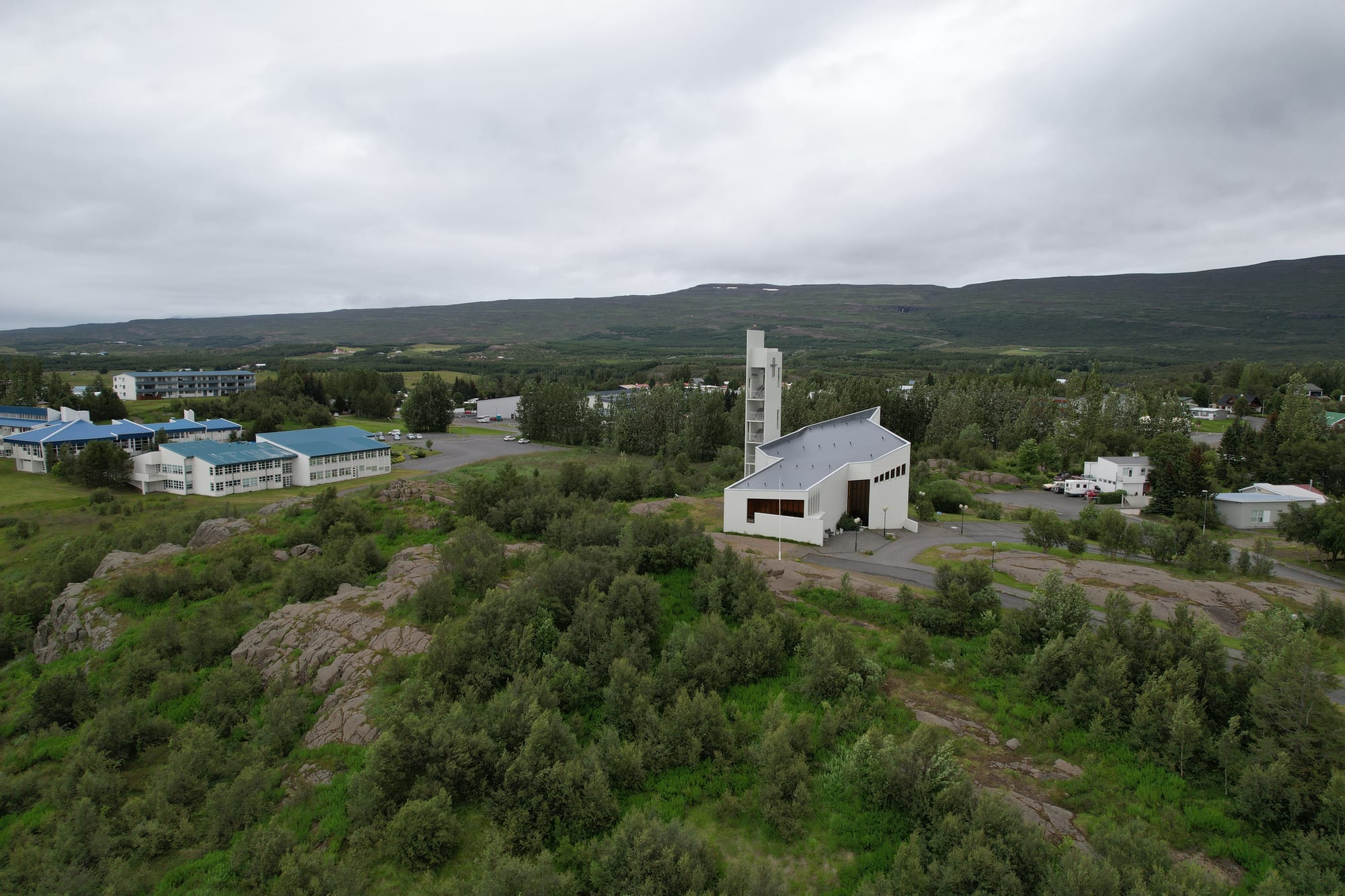
Aerial view of Egilsstaðir's white modern church and bell tower beside a wooded rocky outcrop, with low hills behind

East Iceland, Iceland

Egilsstaðir

Egilsstaðakirkja on the rocky outcrop of Gálgaklettur in the centre of Egilsstaðir. (Eysteinn Guðni Guðnason / Wikimedia Commons · CC BY-SA 4.0)

East Iceland's largest town and its main service, transport and administrative centre, on the east bank of Lagarfljót near the bridge where the region's main roads meet. Founded only in 1947 around a crossroads farm, it grew quickly with the dam and smelter projects of the 2000s and is the base for the forest, waterfalls and canyons of the valleys around it.

Neighbourhoods

  • Egilsstaðir town centre
    • First-time visitors
    • Shopping and supplies
    • Close to public transport

    The compact centre on the east side of Lagarfljót, with the supermarkets, shops, cafés, the swimming pool, the heritage museum and the church on its rocky outcrop. The Ring Road and the road to Seyðisfjörður meet here, and local buses stop in the centre.

    Open in Maps
  • Fellabær
    • Quiet and residential
    • Lake views

    A small town directly across Lagarfljót, joined to Egilsstaðir by a bridge of about 300 metres that carries the Ring Road. It has a bookshop with a café, a petrol station and places to stay, and the airport lies between the two towns.

    Open in Maps

Things to do

In town

  • East Iceland Heritage Museummuseum

    The regional museum in the town centre, with an archive of films and documents on the history of East Iceland.

    Open in Maps
  • Egilsstaðakirkja and Gálgaáslandmark

    The modern church stands beside Gálgaás, a rock where, by legend, an innocent farmer was hanged for murder, and the true killer, also named Valtýr, was hanged on the same spot fourteen years later; a plaque recalls the story.

    Open in Maps
  • Egilsstaðir swimming poolattraction

    The town's pool, with a 25-metre swimming pool, two hot tubs and a water slide.

    Open in Maps
  • Lagarfljótpark

    The long glacial lake beside the town, 25 kilometres long and up to 112 metres deep, where a serpent, the Lagarfljótsormurinn, is believed by some to live in the depths.

    Open in Maps

Short trips from the town

  • Hallormsstaðaskógurpark

    Iceland's first national forest, protected in 1905, about 25 kilometres inland and covering some 740 hectares, with over 40 kilometres of marked trails, an arboretum and two campsites, and Hallormsstaður, the only village in Iceland inside a forest.

    Open in Maps
  • Hengifosstrail

    A 128-metre waterfall over basalt layers banded with thin red clay, reached by a path of 40 to 60 minutes from the car park — the most popular hike in East Iceland.

    Open in Maps
  • Skriðuklausturmuseum

    The ruins of a 16th-century monastery and the 1939 mansion of the writer Gunnar Gunnarsson, now a centre for culture and history with exhibitions and a restaurant, beside a Vatnajökull National Park visitor centre.

    Open in Maps
  • Stuðlagilviewpoint

    A canyon of towering hexagonal basalt columns above a turquoise river in Jökuldalur, which drew international attention after the Kárahnjúkar hydropower project reduced the river's flow.

    Open in Maps
  • Seyðisfjörðurattraction

    The fjord town of Norwegian timber houses and the Norröna ferry, 27 kilometres away over the Fjarðarheiði pass.

    Open in Maps

Eat and drink

Long-standing places and food districts in Egilsstaðir. Hours, ratings and directions come from your maps app, always current.

Egilsstaðir classics

  • Café Nielsenrestaurant

    A café and restaurant in the town centre.

    Open in Maps
  • Klausturkaffirestaurant

    The well-known restaurant in Gunnar Gunnarsson's mansion at Skriðuklaustur, in the valley beyond the forest.

    Open in Maps

Food shops

  • Supermarkets in the centremarket

    Bónus and Nettó, two low-cost supermarket chains, make the town the place to stock up before driving the fjords.

    Open in Maps

Experience Egilsstaðir

History

Egilsstaðir is first mentioned in written records in the 15th century, as a place where a legislative assembly met. Nothing certain is known about the Egill whose farm gave it its name, which makes it unusual among Icelandic towns, most of which are named after landmarks. The nearby river Eyvindará appears in the Saga of the Sons of Droplaug and in the saga of the people of Fljótsdalur.

The town's story really begins with Jón Bergsson (1855–1923), a farmer who bought the Egilsstaðir farm at the end of the 19th century because of its position, predicting "Crossroads will be here." He built a large residential building at the start of the 20th century and, with others, founded the cooperative Kaupfélag Héraðsbúa there in 1909. Bridges over Lagarfljót and Eyvindará and a road over Fagridalur to Reyðarfjörður followed, and the regional headquarters for post and telephone services moved here.

In 1947 the government took the unusual step of founding a new town by act of parliament, with its site chosen by the state planning committee; it began with only 110 people. By 1980 the population had passed 1,000, and in 1987 the town became Egilsstaðabær. It grew quickly during the boom of 2004 to 2008, when the Kárahnjúkar hydropower plant and Alcoa's aluminium smelter at Reyðarfjörður were built, and more slowly after the banking collapse of 2008. A series of mergers followed, and in 2020 the town became part of the new municipality of Múlaþing.

Culture & Customs

As the largest town in the east, Egilsstaðir is where people from across the region come for school, shopping, health care and administration, and its institutions — the upper secondary school, the regional heritage museum and the cooperative tradition begun by Jón Bergsson — reflect that role.

Folklore runs close to the surface. Lagarfljót, the long lake beside the town, is said to hide a serpent, the Lagarfljótsormurinn, which some believe lives in its depths, much as Scotland's Loch Ness is said to. Beside the church stands Gálgaás, the rock where, by legend, the farmer Valtýr in the green jacket was hanged for a murder he did not commit, before the real killer, another Valtýr, was found fourteen years later and hanged on the same spot. The writer Jón Björnsson revived the story as a play staged at the National Theatre, and children still play on the rocks.

Reindeer, introduced to Iceland in the late 18th century, are found only in the east, and herds can be seen in summer around the mountain Snæfell. Respect for the land and the weather governs daily life here as everywhere in Iceland.

Daily Life

About 2,630 people lived in Egilsstaðir in 2024, making it the largest settlement in East Iceland. It is the region's main centre for services, transport and administration, with an airport, an upper secondary school and a health clinic, and it sits near the Lagarfljót bridge where the Ring Road meets the main routes to the rest of the east. Fellabær lies directly across the bridge, and the municipality has run a free shuttle between the two towns.

The town's growth has followed the region's big projects. The construction of the Kárahnjúkar dam and the smelter at Reyðarfjörður brought a rapid expansion between 2004 and 2008, and the population rose by about 40 per cent between 2001 and 2011. Since then growth has been slower, and a new plan for the town centre was drawn up in 2018.

Life here follows the inland climate. Summers bring warm, bright days in the valley, sometimes the hottest in the country. Winters are colder than on the coast, and the passes to the fjords close in storms, but Egilsstaðir's airport and roads keep it the east's link to the rest of Iceland.

Food

Reindeer is the east's own game. The animals live wild on the moorlands of the east, and their meat is considered a special delicacy in Iceland and is usually very expensive. Lamb, whose quality is a point of national pride, is the everyday meat, and fish, dairy and lamb are the pillars of Icelandic cooking as a whole.

The Hérað valley around the town holds Hallormsstaðaskógur, one of the larger forests in Iceland and the country's first national forest. Out in Fljótsdalur, Klausturkaffi at Skriðuklaustur, in the writer Gunnar Gunnarsson's mansion, is a well-known restaurant, and the town's own cafés serve visitors and locals in the centre.

National staples complete the picture: hangikjöt, smoked lamb; harðfiskur, fish dried by cold air and wind and traditionally eaten with butter; skyr, which has the consistency of strained yogurt but is classed as a fresh sour milk cheese; and the pylsa, a hot dog of Icelandic lamb, pork and beef with raw and fried onion, ketchup, sweet brown mustard and remoulade. Bónus and Nettó supermarkets make Egilsstaðir the place to stock up before a drive into the fjords.

Planning tools

Budget

Egilsstaðir costs much the same as the rest of Iceland, but as the region's service centre it has budget supermarkets and more choice of beds than the villages. Most of the sights nearby — the forest, Hengifoss, Stuðlagil — are natural sights reached by car, so a hire car is the main cost for anyone exploring.

Daily Budget Midrange
USD 290–490 (guesthouse or farm stay, one restaurant meal a day, a hire car, the baths or a museum)
Daily Budget Shoestring
USD 120–200 (campsite or hostel, supermarket food, a shared hire car)

Fill the tank and stock up on groceries here before heading into the fjords or the highlands.

Best Time to Visit

June to August, when the valley is at its warmest — Egilsstaðir often sees the highest summer temperatures in the country — and the 4x4 road towards Snæfell, where reindeer herds can be seen in summer, is in use. Winter is colder here than in other towns in the area, with snow and short days, but brings the chance of northern lights.

Suggested Number of Days

The town itself needs a day at most. Most visitors use it as a base and stay three to five days to take in the lake, the forest, the waterfalls, the canyons and the fjord towns nearby. Highland roads add time and need a 4x4.

First Visit
1–2 days
With Surroundings
3–5 days

Transportation

The town is small enough to walk or cycle, though hills and headwinds can make cycling tiring. Most of East Iceland has a joint public bus system, reaching from Borgarfjörður in the north to Höfn in the south, and a local bus runs to Seyðisfjörður. For the forest, the waterfalls and the canyons a hire car is needed, and the road to Snæfell is for 4x4 vehicles only.

Watch for reindeer and sheep on the roads, and check road.is before driving the passes.

Airport & Station Connections

Egilsstaðir Airport, between the town and Fellabær, has Icelandair flights to Reykjavík and car hire desks; it is designated an international airport but as of 2024 had no scheduled international flights. By road, Egilsstaðir lies on the Ring Road, where the main routes of the east meet. The Norröna ferry from Denmark docks at Seyðisfjörður, 27 kilometres away.

Walkability

Easy on foot: the centre is compact, and the longest walking path in town is just over three kilometres. The bridge to Fellabær is a short walk. Pavements can be snowy and icy in winter.

Safety

Iceland has almost no violent crime and is one of the safest countries in the world. Around Egilsstaðir the hazards are weather and terrain: fog and snow on the passes to the fjords, reindeer and sheep on the roads, and slippery rock at the canyon and the waterfalls.

Keep to the marked paths and platforms at Stuðlagil and Hengifoss, and never drive past a closed-road barrier. Check current official travel advice before travelling.

Climate

Egilsstaðir has a subarctic or subpolar oceanic climate, depending on the measure used. Lying low and somewhat shielded from sea winds, it has colder winters than other towns in the area but some of Iceland's warmest summer days; the highest temperature recorded there is 29.8°C, at the airport on 16 August 2025. The climate has warmed noticeably in recent decades.

Summer
daytime highs often exceed 15°C, higher than most of Iceland, though nights are cool
Winter
January is the coldest month; temperatures seldom fall far below 0°C, though winters tend to be colder than in other towns in the area

Local Customs

Tipping is not practised in Iceland, and verbal thanks for good service is the better gesture. Like most Icelandic communities, the town has a heated swimming pool, and staying on marked paths and roads is expected out of respect for the land. Dress is casual and practical.

Outside bars and restaurants, alcohol is sold only in the state shops, Vínbúðin, and the buying age is 20. The blood alcohol limit for drivers is 0.05 per cent.

Common Payment Methods

The currency is the Icelandic króna (ISK). Cards are accepted almost everywhere, including petrol stations and remote guesthouses, so there is little need to carry much cash.