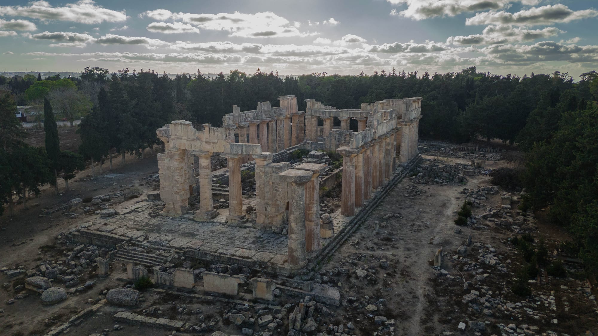
Aerial view of a roofless Greek temple with rows of stone columns standing among pines and scattered blocks

Benghazi & Cyrenaica, Libya

Shahhat

The temple of Zeus at Cyrene, on the edge of Shahhat. (Sami Belsous / Wikimedia Commons · CC BY-SA 4.0)

A small town on the Green Mountain in eastern Libya, built beside and partly over the ruins of Cyrene, the Greek city founded in the 7th century BC that became the leading city of Cyrenaica. Terraced limestone slopes drop from the town towards the Mediterranean, and farming, government work and the archaeological site shape local life. This page is written to explain the city, not to encourage travel.

Neighbourhoods

  • The town centre
    • First-time visitors
    • Everyday services

    Shahhat's main streets carry the shops, bakeries, cafés, mosques and government offices that serve the surrounding farmland. The buildings are mostly low and modern, put up after the ancient site was cleared and protected in the 20th century, and the whole centre can be crossed on foot in a few minutes.

    Open in Maps
  • The edge of the ancient city
    • Historic district
    • Walks and viewpoints

    The western and southern fringes of the town run straight into the archaeological zone of Cyrene, where streets end at fenced ground, cut terraces and standing columns. The land falls away northwards in steps towards the coastal plain, and the view from here takes in both the ruins and the sea.

    Open in Maps
  • The farming slopes
    • Quiet and residential
    • Countryside

    Away from the centre, scattered houses, smallholdings and orchards sit among juniper scrub and pine on the Jebel Akhdar plateau. This is the wettest ground in Libya, green in spring and cool in summer, and the roads through it link the town to Al Bayda and to the coast.

    Open in Maps

Things to do

Cyrene, the ancient city

  • Cyrenelandmark

    A Greek colony of about 631 BC and the chief city of Roman Cyrenaica, with a sanctuary of Apollo beside its spring, an agora and a hillside theatre; a UNESCO World Heritage Site since 1982, added to the List of World Heritage in Danger in 2017.

    Open in Maps
  • Temple of Zeuslandmark

    A Doric temple on the town's edge, among the largest Greek temples ever built, wrecked in the revolt of AD 115 and the earthquake of 365, and largely re-erected between 1967 and 2008.

    Open in Maps
  • The necropolis of Cyrenelandmark

    Rock-cut tombs and carved facades spread over some 10 square kilometres of hillside between the town and the ancient road to Apollonia.

    Open in Maps

Short trips from the town

  • Apollonialandmark

    Cyrene's port at modern Susa, about 16 km north on the coast, with a theatre, Byzantine churches and harbour works now partly under the sea.

    Open in Maps
  • The Green Mountainviewpoint

    The forested upland around the town, Libya's wettest region, rising in terraces from the coast and cut by deep wadis.

    Open in Maps
  • Qasr Libyamuseum

    A small town about 50 km west, the Roman and Byzantine Olbia, with a museum of fifty Byzantine floor mosaics from excavations of the 1950s.

    Open in Maps
  • Ptolemaislandmark

    Another city of the Pentapolis, at modern Tolmeita on the coast west of Shahhat, with streets, cisterns and villas laid out on a grid.

    Open in Maps
  • Al Baydaattraction

    The nearest large city, about 24 km west, with Omar Al-Mukhtar University, hospitals and the airport that serves the region.

    Open in Maps

Eat and drink

Long-standing places and food districts in Shahhat. Hours, ratings and directions come from your maps app, always current.

Shahhat kitchens

  • Town-centre bakeries and grillsneighborhood

    Small bakeries turning out flatbread, and grills serving lamb, chicken and rice, are what the centre offers; there is no restaurant scene beyond everyday places used by residents.

    Open in Maps
  • Green Mountain producemarket

    Stalls and shops sell the plateau's fruit, potatoes, olives and honey, along with dates brought up from the oases further south.

    Open in Maps

Experience Shahhat

History

Greek settlers from the island of Thera founded Cyrene around 631 BC on a terrace of the Green Mountain, a few kilometres inland and high above the sea, beside a spring they dedicated to Apollo. The city grew rich on grain, horses and silphium, a plant used as medicine and seasoning and harvested to extinction in antiquity; its emblem appeared on Cyrenaican coins. With its port Apollonia and the cities of Euesperides, Taucheira and Ptolemais, Cyrene formed the Pentapolis, and it produced the philosopher Aristippus and the mathematician Eratosthenes.

The city passed to the Ptolemies of Egypt and then to Rome in 96 BC; a Roman governor was first sent in 74 BC, and Cyrenaica was later joined with Crete as a single province. A Jewish revolt in 115–117 devastated it, and although the emperors Hadrian and later Justinian rebuilt parts of the city, an earthquake in 262 and another in 365 left it badly damaged. Christian basilicas rose among the older sanctuaries, and after the Arab conquest of the 7th century the site was gradually abandoned.

Modern Shahhat grew beside the ruins. Italian forces established a base on the site in 1913 and excavation has continued there since, and after Libyan independence the settlement expanded as a district centre on the plateau beside the fenced archaeological zone. Cyrene was inscribed on the UNESCO World Heritage List in 1982 and added to the List of World Heritage in Danger in 2017, because of the conflict and the pressure of building on the archaeological zone.

Culture & Customs

Shahhat belongs to the Jebel Akhdar, a part of Cyrenaica with a strong regional identity built on Bedouin tribal belonging, the memory of the Senussi order and the resistance to Italian rule. Tribal ties still shape marriage, local politics and security more than they do on the western coast, and the eastern Arabic dialect spoken here is closer to that of western Egypt than to Tripoli's.

Hospitality follows desert and mountain custom. Tea is poured in rounds, strong and sweet, the last glass often served with peanuts or almonds, and a guest is expected to eat before talking business. Weddings run over several days and draw whole extended families back to the town, and Ramadan evenings are spent moving between relatives' houses. Poetry recited at gatherings remains a respected art in the east.

The ancient city is part of local identity in a complicated way: it is a source of pride, a place children are taken on school visits, and also a constraint, since the protected zone limits where the town can build. Antiquities staff, guards and archaeologists have long formed a small professional community here, and Libyan and foreign missions worked on the site for decades before 2011. Omar Mukhtar, the guerrilla leader hanged in 1931, is honoured across Cyrenaica, and his name is attached to institutions throughout the Green Mountain.

Daily Life

Shahhat is a small town and the administrative centre of its district, with schools, a hospital, government offices and a branch of the region's university system. Most households live from public salaries, farming and small trade, and many have relatives in Al Bayda, the much larger city 24 km west, which supplies the higher-level services.

The plateau around the town is the most productive farmland in Libya: barley and wheat, potatoes and vegetables, olives, figs, almonds and grapes, along with sheep and goats grazed on the scrub. Rain-fed agriculture is possible here in a way it is not almost anywhere else in the country, and the harvest calendar sets the rhythm of the year. Building materials, fuel and cash all pass along the coastal highway from Benghazi.

Daily life has the difficulties common across Libya since 2011: power cuts, fuel and cash shortages, delays in public salaries, and a heavy security presence with checkpoints on the roads. The flood that struck Derna, about 70 km east, in September 2023 killed thousands and was felt across the Green Mountain, where towns took in displaced families. Protecting the archaeological site from illegal building and looting is a live local issue.

Food

Eastern Libyan cooking is Bedouin at heart, built on lamb, barley, bread and dairy, and Shahhat eats what the Jebel Akhdar produces. Bazin, a firm dough of barley flour turned out in a dome and eaten with a lamb or vegetable stew from a shared dish, is the dish most associated with Libya. Couscous, steamed and served with lamb or chicken and vegetables, belongs to festive and communal meals, and rishda, a dish of noodles with onions and chickpeas, appears in home kitchens.

Ramadan has its own table: sharba, a lamb and vegetable soup thickened with orzo-like pasta and coloured with tomato and mint, is served almost every evening, alongside bourek, thin pastry parcels filled with meat, potato or cheese. Asida, a lump of steamed wheat dough eaten with date syrup and melted butter, is made for the Prophet's birthday and for Eid.

The Italian period left pasta in the Libyan kitchen, and imbakbaka — pasta cooked in a spiced tomato and lamb sauce — is common in the east. Local honey from the mountain, figs, almonds and olives are sold from roadside stalls, and dates come up from the southern oases. Fish from the coast at Susa reaches the town's markets. Alcohol is illegal; tea and strong coffee, taken slowly in cafés and at home, are the drinks of the day.

Planning tools

Budget

There is no tourism economy here. The few outsiders who reach the Green Mountain do so on archaeological, aid or business work, arranged through a Libyan sponsor with a driver and security, and costs follow that market rather than any travellers' prices. Hotels are concentrated in Al Bayda and Benghazi rather than in Shahhat itself, and payment is largely in cash.

Daily Budget Midrange
USD 200–400+ (secured hotel in Benghazi or Al Bayda, driver, fixer; paid largely in cash)
Daily Budget Shoestring
USD 150–250 (basic hotel in Al Bayda, local food, shared transport — not achievable without a sponsor)

Costs cannot be planned independently: they depend on the sponsor and the security arrangement, and cash in dinars and US dollars is needed for everything.

Best Time to Visit

In principle spring, when the Green Mountain is green and the wildflowers are out around the ruins, and autumn, when the heat has gone. Winter on the plateau is cool and wet, with occasional snow on the heights nearby. In practice official advice and the security situation, not the season, determine whether any travel is possible.

Suggested Number of Days

The archaeological site is large and spread over several terraces, so it fills more than an afternoon on foot. Two or three days allows for the surrounding district as well. Access, permissions and checkpoints govern the length of a stay far more than anything else.

First Visit
1–2 days
With Surroundings
2–3 days

Transportation

Movement is by road and by private vehicle. The coastal highway from Benghazi climbs the escarpment through Al Marj and Al Bayda to Shahhat and continues east to Derna and Tobruk, and a shorter road drops north to Susa on the coast. There is no railway and no tourist transport; shared taxis and minibuses link the Green Mountain towns for residents.

Journeys pass through checkpoints run by the eastern authorities, and any movement should be arranged with a local sponsor who knows the current rules on the roads.

Airport & Station Connections

The nearest airport is Al Abraq, which serves Al Bayda and lies about 10 km from the town; Benghazi's Benina airport is roughly 200 km away by the coastal road, three to four hours by car. Almost everyone arrives by road from Benghazi or from Tobruk and the Egyptian border.

Walkability

The town is small and flat enough to cross on foot, and the ruins begin at its edge. Inside the archaeological zone the ground is uneven — cut stone, loose blocks, steep terraces and unfenced drops — and there is little shade, so sturdy shoes, water and a guide matter more than distance. There are no pavements or crossings of any standard on the main road.

Safety

Most governments advise against all travel to Libya, including the east. The region is controlled by the eastern authorities and their armed forces, with frequent checkpoints and a risk of arbitrary detention, and the wider risks — terrorism, kidnapping of foreigners, unexploded ordnance from the fighting of 2014–2017 and the near-total absence of consular help — apply here as elsewhere in the country. The archaeological site itself has suffered looting and encroachment over the years.

Globeway covers Libya so its history and its recent tragedy can be understood — not to suggest a visit. Do not travel without an unavoidable reason, professional security support and a full reading of official advisories. Check current official travel advice before travelling.

Climate

The Green Mountain has the mildest and wettest climate in Libya. Rain falls mainly between November and March, mist and low cloud are common on the plateau, and the town is noticeably cooler than the coast below it because of its height of around 600 m.

Summer
warm and dry, generally in the high 20s to low 30s °C, cooler than Benghazi and the coastal plain
Winter
cool and wet, often 8–15°C by day with cold nights, and snow occasionally settles on the higher ground nearby

Local Customs

This is a conservative, tribal part of Libya where Bedouin custom and the Senussi religious tradition remain strong. Dress is modest for both men and women, greetings are unhurried, and hospitality — tea poured in rounds, a meal pressed on a guest — is a serious obligation. Alcohol is illegal throughout the country.

Ask before photographing people, and never photograph checkpoints, soldiers or government buildings; requests to put a camera away should be followed at once.

Common Payment Methods

The currency is the Libyan dinar. Payment is in cash almost everywhere; cards are of little use outside a few hotels in the larger cities, ATMs are unreliable and often out of money, and US dollars in cash are the usual backup. Exchange rates can differ sharply between banks and the parallel market.