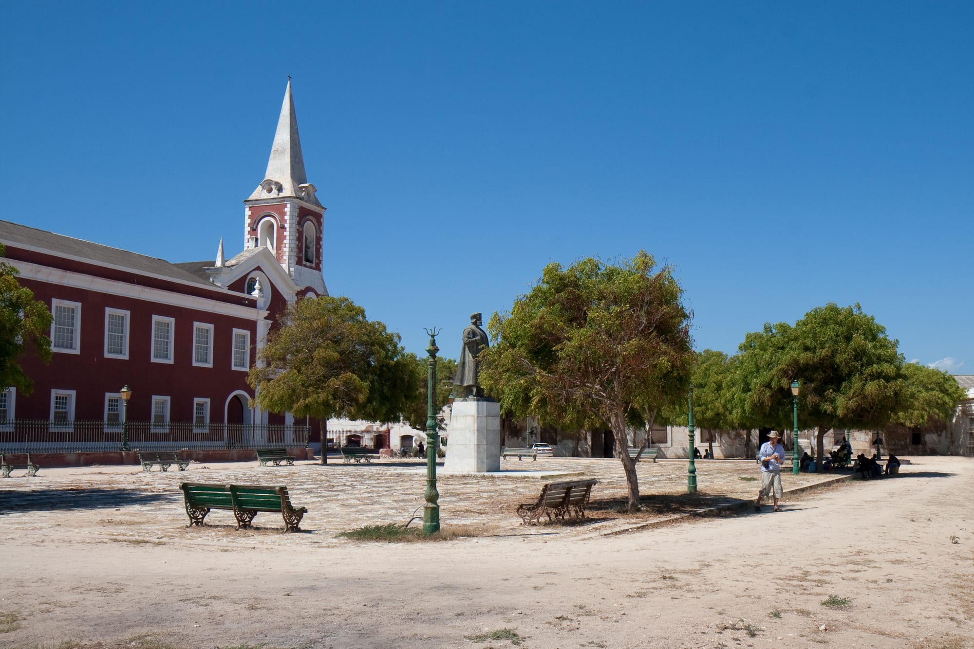
A wide sandy square with benches and trees in front of a long red-and-white church and palace building under a deep blue sky

Ilha de Moçambique, Pemba & the North, Mozambique

Island of Mozambique

The square in front of the Palace and Chapel of São Paulo on the Island of Mozambique. (Stig Nygaard from Copenhagen, Denmark / Wikimedia Commons · CC BY 2.0)

A coral island about three kilometres long off the Nampula coast, joined to the mainland by a single-lane bridge. A Swahili trading town before the Portuguese made it their base in 1507, it was the capital of Portuguese East Africa until 1898 and gave the country its name. Its stone town and reed-roofed Macuti quarter form a UNESCO World Heritage Site.

Neighbourhoods

  • Stone Town
    • First-time visitors
    • Historic district
    • Architecture

    The northern half of the island, built of coral stone and lime — churches, the governor's palace, merchants' houses, warehouses and narrow streets laid out over centuries of Swahili, Indian and Portuguese trade. Many buildings are restored, others stand empty, and most of the island's guesthouses and restaurants are here.

    Open in Maps
  • Macuti Town
    • Local life
    • Markets

    The densely built southern half, named after the palm-thatch roofs of its houses, where most islanders live. Sandy lanes, small shops, the market, the football ground and the cemetery are here, and the day begins and ends around the fishing beaches on its shores.

    Open in Maps
  • The northern tip
    • Historic district
    • Sea views

    The end of the island occupied by the fortress of São Sebastião and the small chapel beyond it, with open ground, the sea on three sides and views back along the stone town.

    Open in Maps
  • The bridge and the mainland shore
    • Beaches
    • Quiet and residential

    The long causeway-bridge and the mainland around Lumbo and the Cabaceiras, with mangroves, beaches and a few lodges reached by road or by boat across the bay.

    Open in Maps

Things to do

Fort and churches

  • Fortress of São Sebastiãolandmark

    The great Portuguese fort at the island's northern tip, begun in 1558 and about fifty years in the building, with thick coral-stone walls, cisterns and a chapel inside; it is described as the oldest complete fort still standing in sub-Saharan Africa.

    Open in Maps
  • Chapel of Nossa Senhora de Baluartelandmark

    A small whitewashed chapel of 1522 on the rocks beyond the fortress, often described as the oldest European building in the southern hemisphere.

    Open in Maps
  • Palace and Chapel of São Paulomuseum

    Built in 1640 as a Jesuit college and later the governor's residence, now a museum of furniture, porcelain and objects from the island's trading centuries.

    Open in Maps
  • Museum of Sacred Artmuseum

    Religious paintings, carvings and silver from the island's churches, including a Makonde crucifix, displayed in the Church of the Misericórdia.

    Open in Maps

The two towns

  • Stone Town streetsneighborhood

    Coral-and-lime houses, warehouses and church façades in a grid of narrow streets, some restored as guesthouses, others roofless, with the sea at the end of most of them.

    Open in Maps
  • Macuti Townneighborhood

    The lived-in half of the island, with thatched houses, the market, mosques and the fishing beaches where boats are drawn up and repaired.

    Open in Maps
  • The bridge to the mainlandlandmark

    A single-lane bridge about three kilometres long, built in the 1960s, crossed by traffic in alternate directions and walked by islanders for the view over the water.

    Open in Maps

The sea

  • Dhow trips from the islandattraction

    Wooden sailing boats take visitors across the bay to sandbanks, mangrove shores and the mainland villages, with the island's low skyline behind.

    Open in Maps
  • Goa Island lighthouselandmark

    A square lighthouse of 1876, still in service, on an uninhabited coral island about five kilometres east at the entrance to Mossuril Bay, reached by boat when conditions allow.

    Open in Maps
  • Chocas beachbeach

    A long beach on the mainland across Mossuril Bay, about 40 kilometres away by unpaved road or a shorter crossing by boat, with the old Cabaceira villages nearby.

    Open in Maps

Eat and drink

Long-standing places and food districts in Island of Mozambique. Hours, ratings and directions come from your maps app, always current.

Island classics

  • Seafood in the stone townneighborhood

    Small restaurants in restored houses serve prawns, crab, calamari and line fish with coconut rice, matapa and piri-piri.

    Open in Maps
  • Fish landings in Macuti Townmarket

    Boats come in through the day and the catch is sold and grilled on the sand — the cheapest and freshest food on the island.

    Open in Maps

Markets and snacks

  • The island marketmarket

    Cassava, coconuts, tomatoes, dried fish and cashews, with stalls selling chamuças and fried snacks around the edges.

    Open in Maps
  • Cafés on the main squarecafe

    Coffee, bread and pastries in the shade near the palace, in the Portuguese habit that survives across Mozambique.

    Open in Maps

Experience Island of Mozambique

History

The island was a Swahili trading settlement long before Europeans saw it, with a sheltered anchorage on the route between the Zambezi goldfields, the Comoros and the wider Indian Ocean; its ruler when the Portuguese arrived was a sheikh whose name, in one common account, gave Moçambique to the island and then to the whole country. Vasco da Gama called in 1498, and Portugal took the island in the first decade of the sixteenth century, building a hospital, a chapel and, from 1558, the great fortress of São Sebastião to hold the anchorage against Dutch and other rivals; sieges in the early 1600s failed against its walls.

For nearly four centuries the island was the capital of Portuguese East Africa and one of the busiest ports on the coast: a transhipment point for ivory, gold and cloth, and, in the eighteenth and nineteenth centuries, a centre of the slave trade to the Indian Ocean islands and the Americas — a history the island's buildings and cemeteries record. Merchant families from Goa, Gujarat, Arabia and Portugal built the stone houses and warehouses that still line its streets.

The end came with steamships and the mainland. Trade moved to the new harbour at Nacala, and in 1898 the capital was transferred to Lourenço Marques, the modern Maputo. The island became a quiet provincial town, its stone half slowly emptying as the thatched Macuti half filled. A bridge to the mainland opened in the 1960s. In 1991 UNESCO inscribed the whole island as a World Heritage Site, and since then restoration work, much of it with Portuguese and other foreign support, has repaired churches, the palace and a growing number of houses.

Culture & Customs

Ilha is a meeting place made permanent. Its people are mostly Makhuwa and coastal Muslims whose families have traded, married and worked across the Indian Ocean for generations, and the island's culture carries Swahili, Arab, Indian and Portuguese threads at once. Mosques, Catholic churches and a Hindu temple stand within a few minutes of each other, and Islamic festivals set the calendar for most families.

The best-known local tradition is tufo, a dance performed by women in matching capulanas to songs and frame drums, associated with Islamic celebrations along the northern coast and danced here at weddings and religious festivals. Silver and craft work, model dhows, basketry and painted furniture are made and sold in the streets, and the island has drawn artists and musicians from across Mozambique because of its setting and its history.

Life is conducted outdoors and at a slow pace. Men fish and repair boats, women carry water and trade, children play football on the open ground by the fortress, and the evening brings everyone onto the seafront and the square. Greetings are unhurried and formal in both Portuguese and Emakhuwa. Modesty in dress is the norm, and visitors are expected to ask before photographing people, houses or prayers. Ramadan is widely observed, and the day's rhythm changes noticeably during it.

Daily Life

About 14,000 people live on the island, most of them in Macuti Town, which occupies the southern half in a dense pattern of thatched and sheet-metal houses along sandy lanes. The stone town's population is much smaller; many of its buildings are used as guesthouses, offices, schools or storage, and some stand roofless. The island's district includes mainland areas, and many families have relatives across the bridge.

Fishing is the island's economic base, with boats going out for reef fish, octopus and prawns, and the catch sold at the landings and carried to the mainland. Tourism, restoration work, small trade and government jobs make up much of the rest, and money sent by relatives working in Nampula, Nacala and South Africa matters to many households. Unemployment is high and most work is informal.

The day begins before dawn with prayers and the first boats, the market fills in the morning, and the middle of the day is quiet in the heat. Fresh water has to be brought from the mainland and supply is a constant concern, as are electricity cuts, crowding and sanitation in Macuti Town, the cost of living, and the slow pace of restoration in the stone town. Erosion and rising seas along the shore are discussed more each year.

Food

Island food is coastal and Indian Ocean food: fish, prawns, crab, octopus and calamari, grilled over charcoal or stewed in coconut milk with garlic and chilli. Rice cooked with coconut is the usual accompaniment rather than the maize xima of inland Mozambique, and matapa — cassava leaves ground with peanuts and cooked with coconut — appears on most tables.

Trade left its mark. Chamuças, the triangular fried pastries of Indian origin, are sold at the market and on the street, curries and spiced rice dishes are common, and cashews, mangoes, papaya and coconut are everyday foods rather than treats. Bread rolls, coffee and custard tarts are the Portuguese contribution, taken in the morning on the main square.

Drinks are tea, strong coffee, coconut water taken straight from the nut, and sugarcane and fruit juices; alcohol is available in the restaurants and guesthouses but plays little part in the life of a mostly Muslim town. The simplest and best meal on the island is fish bought at a landing beach and grilled on the sand with lime and piri-piri.

Planning tools

Budget

The island has a wide range for such a small place: simple guesthouses and pensões in Macuti Town and on the edge of the stone town, and restored merchants' houses run as small hotels that cost far more. Food is cheap at the fish landings and market, moderate in the restaurants. Boat trips and the road transfer from Nampula are the other main costs.

Daily Budget Midrange
USD 100–250 (restored guesthouse or small hotel, restaurant meals, a dhow trip, transfers)
Daily Budget Shoestring
USD 35–60 (guesthouse or pensão, market food and grilled fish, shared transport)

Bring enough meticais: cash machines on the island are few and unreliable, and most guesthouses and all small restaurants take cash only.

Best Time to Visit

May to November, the dry season, is the time to come: warm days, calm seas for boat trips and passable roads from Nampula. December to April is hot and humid with heavy rain, and the coast carries a cyclone risk late in the wet season.

Suggested Number of Days

Two days is enough for the island itself, which is walkable end to end. Three or four allow for boat trips across the bay and the mainland beaches, and for the slow road journey each way from Nampula.

First Visit
2 days
With Surroundings
3–4 days

Transportation

Nothing on the island needs a vehicle: it is about three kilometres long and everything is within walking distance, with a few taxis, tuk-tuks and bicycles. The bridge carries traffic in one direction at a time and is closed to larger vehicles. Boats and dhows from the beaches serve the mainland shore, the Cabaceiras and the sandbanks, and chapas run from the bridge end towards Nampula.

Agree the price and the return arrangement before taking a boat, and check the sea conditions and the tide, since crossings depend on both.

Airport & Station Connections

Nampula, about 180 kilometres inland, has the region's main airport with domestic flights, and the road from there takes roughly three hours by car or longer by chapa, the last stretch crossing the bridge. Buses and chapas also run up the coast, and Lumbo Airport, on the mainland side of the bridge, also serves the island.

Walkability

The island is entirely walkable and walking is how it is best seen: the stone town's streets are short and flat, the fortress is at one end and the market at the other, and no walk takes more than half an hour. Surfaces are sandy or broken paving, there is little shade in the middle of the day, and lanes in Macuti Town are narrow and unlit at night.

Safety

The island lies in Nampula province, away from the insurgency that has affected Cabo Delgado since 2017, and is calm, with theft and opportunistic crime the practical risks rather than violence. Sea conditions, strong currents around the island, malaria and the heat matter more day to day. Post-election protests reached Nampula province in late 2024.

Most governments advise against all travel to Cabo Delgado province. Travel by day on the roads from Nampula, keep valuables out of sight, use mosquito precautions and prophylaxis, and take local advice before swimming or setting out by boat. Check current official travel advice before travelling.

Climate

Tropical and strongly seasonal, tempered by sea breezes. The wet season runs from about December to April, hot and humid with heavy rain and a cyclone risk; the rest of the year is dry and warm with clear skies. This is the southern hemisphere, so summer falls in December to February.

Summer
hot and humid, December–February, around 30–33°C by day with heavy rain and little breeze
Winter
warm and dry, June–August, around 25–28°C by day, cooler at night and often windy

Local Customs

The island is largely Muslim, and Islamic practice shapes the week, with Friday prayers and the mosques central to Macuti Town; a Hindu temple and Catholic churches stand nearby, a legacy of centuries of trade. Modest dress away from the beach is expected, and swimwear is for the shore only. Emakhuwa and a coastal Swahili-influenced speech are used at home, Portuguese in offices and schools.

Ask before photographing people, houses or prayers, dress with covered shoulders and knees in the streets and around mosques, and be discreet with alcohol, which is sold but not part of most islanders' lives.

Common Payment Methods

The currency is the metical, and the island runs on cash. Cash machines are few and can be empty or out of service, so most visitors draw money in Nampula before coming. A few of the larger guesthouses accept cards; US dollars and South African rand are sometimes changed informally but at poor rates.