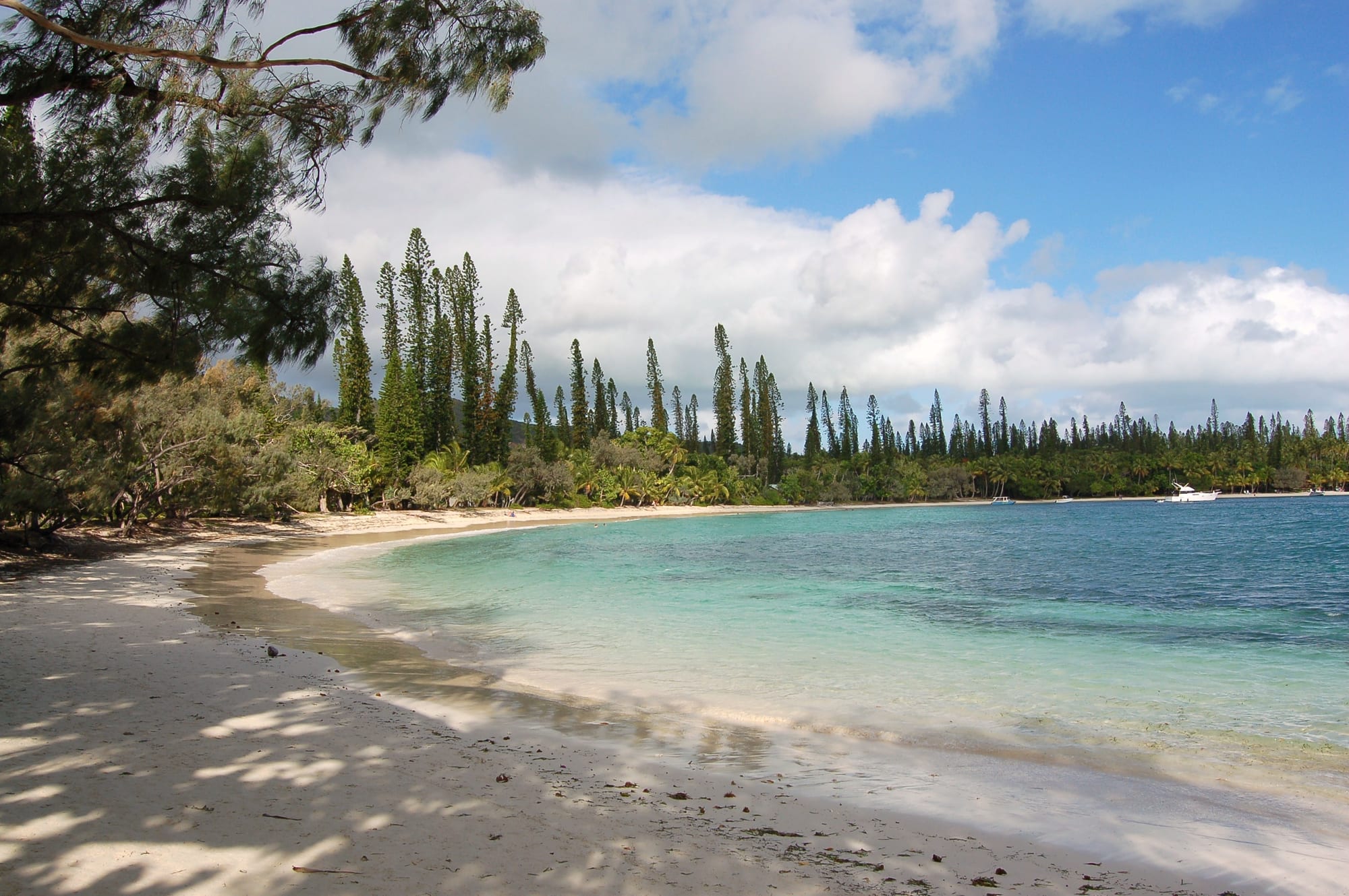
A curving white-sand beach beside pale turquoise water, backed by tall narrow columnar pines and palms under scattered cloud

New Caledonia

Isle of Pines

Kanumera Bay on the Isle of Pines, backed by the columnar pines that grow along the island's shores. (Bahnfrend / Wikimedia Commons · CC BY-SA 3.0)

An island commune off the southern tip of New Caledonia, known in Kanak as Kunié, ringed by white sand bays and the tall columnar pines that gave it its European name. Home to around two thousand people in scattered villages, it holds the remains of a French penal settlement, a natural sea pool at Oro and reefs inside the territory's great lagoon.

Neighbourhoods

  • Kuto and Kanumera
    • First-time visitors
    • Beaches
    • Close to the ferry

    The narrow isthmus on the west coast, with a long sheltered beach on one side and a smaller bay around a wooded rock islet on the other. Most of the island's hotels and guesthouses are here, the ferry from Nouméa ties up at the Kuto wharf, and the two beaches are a few minutes apart on foot.

    Open in Maps
  • Vao
    • Local life
    • Historic district

    The island's main village and administrative centre in the south, gathered around the 19th-century mission church, with a renovated chapel on the hill above, the town hall, shops, a school and a small market. The great chief's residence is nearby, and the island's Catholic life centres here.

    Open in Maps
  • Oro and Upi
    • Beaches
    • Quiet and residential

    The eastern side of the island, reached by a road across the interior, where a shallow channel lined with pines forms a natural sea pool and a wide bay of rock pinnacles is crossed by traditional sailing canoes. A resort and a few guesthouses stand near the water, otherwise it is very quiet.

    Open in Maps
  • Gadji and Saint-Maurice
    • Quiet and residential
    • Walks and viewpoints

    The north and east coasts, with scattered hamlets, mangroves and reef flats, and dirt tracks leading to shallow lagoon beaches used mainly by islanders.

    Open in Maps

Things to do

Beaches and bays

  • Kuto Baybeach

    A wide crescent of fine white sand and calm, shallow water on the west coast, backed by pines and the island's main cluster of accommodation.

    Open in Maps
  • Kanumera Baybeach

    A sheltered bay for swimming and snorkelling, with a wooded rock islet just offshore that is a customary sacred site and is not to be climbed.

    Open in Maps
  • Oro Bay natural poolbeach

    A shallow pool of clear sea water on the east coast, separated from Oro Bay by a barrier of coral and reached by a forest walk of about forty minutes from the Baie d'Upi, with reef fish over the sand.

    Open in Maps
  • Baie d'Upiattraction

    A broad eastern bay studded with eroded coral pinnacles, crossed by traditional outrigger sailing canoes that carry visitors between Saint-Joseph and the walk to the Oro pool.

    Open in Maps

Walks and viewpoints

  • Pic N'Gaviewpoint

    The island's high point at 262 metres, climbed on an exposed track, with a view over the bays, the pine forest and the lagoon.

    Open in Maps
  • Queen Hortense's Caveattraction

    A limestone cave hung with stalactites and fringed with ferns, properly the Grotte d'Oumagne, known after Kanedjo, called Queen Hortense, who shared the island's chieftaincy until 1883.

    Open in Maps

History and villages

  • Vao mission churchlandmark

    Notre-Dame-de-l'Assomption, the church of the Marist mission at Vao, whose first stone church was blessed in 1860, still the centre of the island's Catholic life.

    Open in Maps
  • Penal settlement ruins at Ourolandmark

    Remains of the deportation settlement set up in the south-west of the island from 1872, where the water tower built in 1874–75 and still in service is the best-preserved building.

    Open in Maps
  • Deportees' cemeterylandmark

    A graveyard near Ouro holding about 230 graves of deportees who died in the penal settlement, all but two of them anonymous.

    Open in Maps

Eat and drink

Long-standing places and food districts in Isle of Pines. Hours, ratings and directions come from your maps app, always current.

Island classics

  • Bougnarestaurant

    Yam, taro and sweet potato baked with chicken, fish or crab and coconut milk in banana leaves in an earth oven; guesthouses and small family tables prepare it to order.

    Open in Maps
  • Lobster, crab and reef fishrestaurant

    Lagoon lobster, mangrove crab, snails and grilled reef fish are the island's staples, served at the hotels and at snack bars near the beaches.

    Open in Maps

Where people eat

  • Kuto and Kanumera beach snacksneighborhood

    A handful of simple beachside kitchens and hotel dining rooms on the isthmus, serving fish, sandwiches, steak and cold drinks.

    Open in Maps
  • Vao village shopsmarket

    Small general stores and a market in the main village supply bread, tinned goods, fruit and vegetables for self-catering, with supplies arriving by boat and plane.

    Open in Maps

Experience Isle of Pines

History

The island has been settled for around three thousand years, since the Lapita period, and its people are known as the Kuniés, who speak Numèè. Kanak society here was organised around clans and chieftaincies under a great chief whose line is still recognised, and Numèè is spoken alongside French. Trade and marriage linked the island to the Loyalty Islands and to the southern mainland.

James Cook sighted the island in 1774 and named it for the tall columnar pines visible from the sea. Sandalwood traders followed in the 1840s, bringing disease and firearms, and Marist missionaries landed in August 1848 and founded a station at Vao; the islanders converted to Catholicism, and the first stone church was blessed in 1860. France annexed New Caledonia in 1853 and, from 1872, used the island as a place of deportation: some three thousand Communards sentenced after the Paris Commune, along with other political prisoners and Algerian deportees, were held in five settlements of which Ouro is the best known, until amnesties in the late 1870s and 1880s allowed most to leave. The water tower of 1874–75, still in service, and the deportees' cemetery survive.

After the penal era the island returned to farming, fishing and copra, and its population remained small. In the 20th century the great chieftaincy retained its authority. Tourism began in earnest in the later 20th century, the island being a short flight or a ferry crossing from Nouméa. The unrest that struck the capital in 2024 hit the island through the collapse of visitor numbers on which many families depend.

Culture & Customs

Customary organisation is the framework of island life. Clans hold land, reef and forest, a great chief and clan chiefs are recognised alongside the elected commune, and the Customary Senate of New Caledonia includes representatives from the island. La coutume — presenting cloth, a little money and a few words of explanation — opens any request, whether to stay on family land, use a beach track or hold an event, and several well-known sites are managed and charged for by the families who hold them. Some places, such as the islet in Kanumera Bay, are tabu and must be left alone.

Catholicism is deeply woven in. The Vao church is the centre of the island's religious calendar, Sundays are for mass and rest, and the Marist mission that landed in August 1848 is bound up with clan identity. Feast days, weddings and funerals bring large gatherings, yam and taro presentations and the cooking of bougna in earth ovens.

The island is also known for its canoe tradition: the lateen-rigged outrigger sailing pirogues that cross the Baie d'Upi are working craft as well as a service for visitors, and boat handling, fishing and weaving are practical skills held locally. Numèè is spoken at home by many families, French is universal, and English is limited. Visitors are expected to be quiet, to ask rather than assume, and to accept that access to land and water is somebody's decision to give.

Daily Life

The commune counted 2,037 people at the 2019 census, living in Vao and a ring of smaller villages and tribes, with the commune's offices, school and dispensary at Vao. Almost everyone is Kanak — about 94 per cent, in eight tribes — and most households combine several sources of income: work in the hotels, guesthouses and transport that serve visitors, jobs with the commune or the province, fishing, and gardens of yam, taro, cassava and banana.

Supplies come by boat and plane from Nouméa, which makes shop prices high and availability uneven, and many families depend on their own produce and catch. Tourism is the cash engine: the hotels and the day-trip trade from Nouméa support drivers, cooks, guides and canoe crews, so the fall in visitor numbers after 2024 was felt immediately and widely. Water, electricity and waste management on a small island with peaks of visitors are recurring practical problems, and young people leave for Nouméa for study and work.

The rhythm is slow and early. Mornings are for gardens, fishing and school runs, the middle of the day is hot and still, and late afternoon brings swimming, football and visiting. Sunday belongs to church and family. Conversation turns on the ferry and flight schedules, the state of the tourist season, the price of freight and, as everywhere in the territory, the unresolved political question of New Caledonia's future.

Food

Island cooking is Kanak and coconut-based, with the sea close at hand. Bougna is the dish of occasions: yam, taro and sweet potato layered with chicken, fish or crab, soaked in coconut milk, wrapped in banana leaves and baked over hot stones in an earth oven for a couple of hours. Yams carry particular importance, tied to the customary calendar and to presentations between clans, and taro and cassava fill out the daily starch.

From the lagoon come lobster, mangrove crab, reef fish, octopus and the large sea snails gathered on the flats, all usually grilled or cooked in coconut milk. Escargots de l'Île des Pins, the large endemic land snail also called the bulime, are gathered traditionally for eating and are a local speciality, appearing on hotel menus when supply allows. Fresh coconut, pawpaw, banana and mango are everyday fruit.

French habits sit alongside this: baguettes and pastries arrive with the supply boat, coffee is drunk strong, and the hotels serve fish with French sauces and imported wine. Everyday shopping in Vao means tinned meat and fish, rice, frozen chicken and long-life goods from the mainland, because freight decides what is on the shelves. Most visitors who are not in a hotel self-cater and buy fish or crab directly from families, which is also the cheapest way to eat well here.

Planning tools

Budget

The island is expensive, with a small number of hotels and guesthouses and nearly everything brought from the main island. Accommodation, boat trips and the canoe crossing are the main costs; the beaches, the walks and the Oro pool involve little or nothing beyond a small access fee at some customary sites. Self-catering from the village shops saves a good deal.

Daily Budget Midrange
USD 210–480 (hotel or resort room, restaurant meals, boat and canoe trips, transfers)
Daily Budget Shoestring
USD 80–140 (guesthouse or tribal homestay, self-catering, walking and shared transport)

Accommodation, transfers and the canoe trips should be booked ahead, since capacity is small and the ferry and flights fill quickly in the dry season.

Best Time to Visit

August to November is the most reliable period, with dry, warm days, good water clarity and trade winds. December to April is hotter and more humid, with cyclones possible between January and March. May to July is cooler and quieter, and the sea can feel cold to some swimmers in midwinter.

Suggested Number of Days

Two or three days suits the island at a slow pace. Four or five allow for snorkelling, diving or more time in the villages. Ferry and flight schedules, and the weather on the east coast, tend to decide the length of a stay.

First Visit
2–3 days
With Surroundings
4–5 days

Transportation

A road loops around the island, with unsealed branches to the coast. There is no public transport and very few taxis; hotels and guesthouses run transfers, and some visitors hire a car, a scooter or a bicycle on the island or bring a car across on the ferry. Boats and traditional sailing canoes cover the eastern bays.

Distances are short but walking between bays takes time in the heat, so a transfer or a hired vehicle is worth arranging in advance.

Airport & Station Connections

Air Calédonie flies from Magenta airport in Nouméa to the island's airport at Moué in well under an hour. A fast passenger catamaran crosses from Nouméa in about two and a half hours and ties up at the Kuto wharf.

Sea crossings can be rough and are occasionally cancelled in strong winds, so leaving a buffer before an onward international flight is sensible.

Walkability

The Kuto isthmus is easily walked, with the two main beaches, the wharf and most accommodation within a few hundred metres of each other. Beyond it distances are real — Vao is a few kilometres away, Oro further still — on roads with little shade and no pavements, so walking is pleasant for the coast tracks and the Pic N'Ga climb but impractical for crossing the island.

Safety

The island is quiet and crime is rare; the unrest of May 2024 was concentrated in and around Nouméa rather than here, though the political question behind it is not settled — an agreement on the territory's future was signed at Bougival in July 2025 and has still to be approved — and travel to the island depends on services from the capital. The everyday hazards are natural: strong sun, currents in the passes and at the ends of the bays, sharp coral and rock, stonefish and cone shells on the reef, and an exposed climb on Pic N'Ga.

Wear reef shoes on rocky shorelines, ask locally before swimming away from the main beaches, respect customary sites such as the rock in Kanumera Bay, and carry water on the walks. Check current official travel advice before travelling.

Climate

Tropical but tempered by the trade winds, slightly warmer than Nouméa. In the southern hemisphere summer runs from December to February; the wet season lasts from November to April, with cyclone risk from January to March, while May to September is drier with cooler nights.

Summer
warm and humid from December to February, around 29°C by day, with showers and the cyclone season
Winter
mild and dry from June to August, around 24°C by day and cooler after dark, with steady wind

Local Customs

This is a Kanak island with strong customary authority: land, beaches and forest tracks are held by clans, a great chief and clan chiefs hold recognised positions, and some sites are tabu. La coutume — a small offering with a few words — opens any request to visit or stay on customary land, and access to certain beaches, caves and paths is charged or controlled by the families who hold them. Sunday is quiet and church-centred, and dress in the villages is modest.

Ask before entering land, taking photographs of people or houses, or swimming off an unfamiliar shore, do not climb the rock islet in Kanumera Bay, and greet people in French rather than English where possible.

Common Payment Methods

The currency is the CFP franc, pegged to the euro. Card acceptance is limited to the larger hotels and a few businesses, and there is little in the way of banking on the island, so cash brought from Nouméa is needed for shops, snacks, transfers and customary site fees.