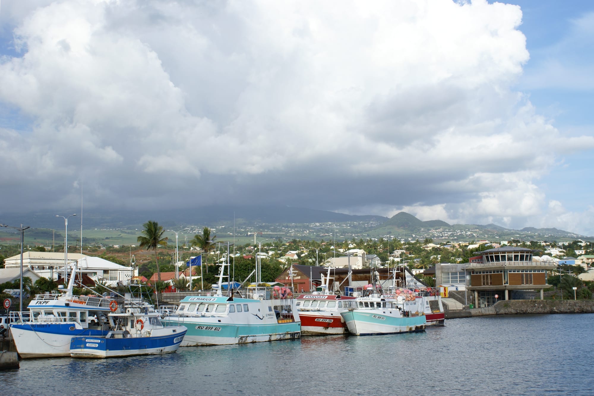
Brightly painted fishing boats moored along a harbour quay, with the low town and cloud-covered green mountains behind

Réunion

Saint-Pierre

The fishing quay in the harbour of Saint-Pierre, with the southern slopes of the island behind the town. (B.navez / Wikimedia Commons · CC BY-SA 4.0)

The main town of southern Réunion, on the island's dry south coast where the mountains fall towards the sea. Founded in 1735 and later the port of the sugar-growing south, it keeps a grid of Creole houses behind a seafront of beach, harbour and promenade, and serves as the base for roads climbing to the Piton de la Fournaise volcano.

Neighbourhoods

  • Centre-ville
    • First-time visitors
    • Historic district
    • Best for food

    The old grid between the seafront and the main avenues, with the town hall in a former East India Company warehouse, the church, markets and streets of shops and Creole houses. Most bars and restaurants are here, and the whole quarter is walkable.

    Open in Maps
  • The seafront and the harbour
    • Beaches
    • Evening walks
    • Nightlife

    A long promenade running from the sandy, reef-sheltered town beach to the fishing and marina basins. Kiosks, benches, playgrounds and restaurant terraces line it, and it fills in the late afternoon and at weekends.

    Open in Maps
  • Terre-Sainte
    • Local life
    • Fishing quarter
    • Quiet and residential

    The old fishing quarter east of the centre, nicknamed the fishermen's village, with small houses along the coast, a church, Tamil chapels and a strong local identity. Traditional boats are still hauled up by hand beside the harbour.

    Open in Maps
  • Ravine des Cabris and the middle slopes
    • Quiet and residential
    • Local life

    Residential districts rising inland from the coast towards Le Tampon, cooler than the seafront, with schools, shops and housing estates rather than sights. Most people who work in the town live in this belt.

    Open in Maps
  • Pierrefonds and the western edge
    • Close to transport
    • Business

    The flat, sunny plain west of the centre where sugar cane still grows, holding the small airport, business parks and new housing. It is practical rather than pretty, but convenient for the coast road towards Saint-Louis.

    Open in Maps

Things to do

Beaches and the coast

  • Manapany-les-Bainsbeach

    A small coastal village east of Saint-Pierre with a natural rock pool sheltered from the swell, below cliffs and cane fields.

    Open in Maps
  • L'Étang-Salébeach

    A black-sand beach west along the coast, popular with surfers, in a commune with a coastal forest and an 18-hole golf course.

    Open in Maps
  • Saint-Philippeattraction

    A village on the wild south-east coast beyond the volcano, where lava flows reach the sea and basalt cliffs take the full swell.

    Open in Maps

The volcano and the highlands

  • Piton de la Fournaiselandmark

    One of the world's most active volcanoes, reached by road from the south through the Plaine des Cafres to the viewpoint at the Pas de Bellecombe on the rim of its caldera.

    Open in Maps
  • Plaine des Sablesviewpoint

    A bare plateau of volcanic scoria crossed by the forest road to the volcano, often compared to a lunar landscape.

    Open in Maps
  • Cirque de Cilaosattraction

    The eroded mountain amphitheatre north-west of the town, entered by a road of hairpin bends from Saint-Louis and ringed by walls of rock.

    Open in Maps
  • Le Tamponattraction

    The town on the slopes immediately above Saint-Pierre, cooler and greener, and the gateway to the Plaine des Cafres and the volcano road.

    Open in Maps

Creole villages nearby

  • Entre-Deuxattraction

    A village of traditional Creole houses between two branches of the Saint-Étienne river, known for its Creole architecture and the trails up the Dimitile.

    Open in Maps
  • Petite-Îleattraction

    A quiet commune of cane fields and small roads east of the town, named after the islet off its shore, with viewpoints along the coast.

    Open in Maps
  • Saint-Josephattraction

    The commune at the southern tip of the island, crossed by the Rivière des Remparts and the Rivière Langevin, and the way in to the wild south-east coast.

    Open in Maps
  • Saint-Louisattraction

    A working town west of Saint-Pierre with one of the island's two sugar factories, Hindu temples and the road up into the Cirque de Cilaos.

    Open in Maps

Practical landmarks

  • Pierrefonds Airporttransit hub

    The island's second, smaller airport, about 5.5 kilometres west-north-west of the centre; it had no scheduled commercial flights at the start of 2026.

    Open in Maps

Seasonal events

  • Grand RaidOctober

    The ultra-trail that crosses the island starts in Saint-Pierre, and the town fills with runners and crews before the race sets off.

  • Fèt Kaf, the abolition commemoration20 December

    The island holiday marking the abolition of slavery in 1848, with maloya concerts, kabars and ceremonies along the seafront.

  • DipavaliOctober or November

    The Tamil festival of lights, marked with lamps, sweets and temple ceremonies by the south's Malbar community.

Eat and drink

Long-standing places and food districts in Saint-Pierre. Hours, ratings and directions come from your maps app, always current.

Markets

  • Town-centre markets and food shopsmarket

    Everyday produce, fish from the local boats, spices and snack counters in and around the centre, busiest in the morning.

    Open in Maps
  • The Saturday marketmarket

    The town's weekly Saturday-morning market, which with the fishing harbour is one of the main reasons to spend an unhurried day in Saint-Pierre.

    Open in Maps

Food districts

  • The seafront terracesneighborhood

    Creole tables, pizzerias and bars line the boulevard facing the beach and the marina, the town's main eating and evening strip.

    Open in Maps
  • Terre-Sainteneighborhood

    The fishing quarter's small restaurants and takeaways serve fish and octopus cari, samoussas and bouchons close to where the boats land.

    Open in Maps

Experience Saint-Pierre

History

Saint-Pierre was founded in 1735, when the island was run by the French East India Company, on the dry southern coast. The plain behind it was planted first with coffee and then, decisively, with sugar cane, and the town grew as the port and administrative centre of the south, shipping sugar out through an exposed roadstead until a proper harbour was built between 1854 and 1882.

Sugar shaped the town's society as well as its economy. Enslaved workers from Madagascar and East Africa cleared and cut the cane until abolition in 1848, after which indentured labourers arrived from South India, together with Gujarati Muslim traders and Chinese shopkeepers who settled in the streets near the market; their temples, mosque and shops remain part of the centre. The town hall has occupied a former Company warehouse, completed in 1773, since 1825, and the old fishing quarter of Terre-Sainte kept its own life east of the centre.

Departmentalisation in 1946 and the closure of most small sugar mills in the 20th century turned Saint-Pierre from a plantation port into a service town. Schools, hospitals, university faculties, administration and retail parks spread inland across the cane plain; the harbour now holds some 400 berths for fishing and pleasure boats, and the seafront given over to a promenade and public beach. It is the island's third-largest commune and is often regarded as its second city.

Culture & Customs

Saint-Pierre has a reputation on the island for going out. The seafront bars and restaurants, the concerts held on the front and the weekend crowds make it the centre of southern nightlife, and maloya — the drum-and-chant music created by enslaved workers and now a symbol of Réunionnais identity — is played at kabars here as much as anywhere on the island, alongside the lighter séga and visiting acts from the region.

Religious life is mixed and public. Catholic parishes and their processions share the calendar with Tamil temples whose Dipavali celebrations are important in the south, with a mosque and a Chinese temple community near the centre, and many families keep more than one tradition. The 20 December abolition holiday, Fèt Kaf, is marked with music and ceremonies along the front.

Terre-Sainte, the fishing quarter, has its own identity, and the sea is central to the town's sense of itself despite the restrictions on swimming along much of the island's coast. Sport and the outdoors matter: the Grand Raid ultra-trail sets off from the south each October, and cycling and trail running fill the slopes above the town. Sundays belong to family picnics on the grass behind the beach.

Daily Life

About 85,000 people live in Saint-Pierre, making it the third largest commune on the island and the anchor of an urban area that runs up the slope into Le Tampon and along the coast. The population is young, and the town's university faculties and large secondary schools bring students down from the surrounding communes.

The economy is built on administration, health, education, retail and tourism, with sugar cane still grown on the plain around Pierrefonds and fishing based in the harbour. Employment is the town's chief social problem, as it is across the island, with unemployment far above the mainland French rate and highest among the young; many leave for mainland France to study or find work, and some return.

Daily life follows the heat. Shops and offices open early, the middle of the day is slow, and the seafront fills from late afternoon with runners, families and football on the sand until well after dark. Housing spreads inland up the slope, where the air is cooler, and the daily commute down to the coast and along the highway is heavy at both ends of the day. The cyclone season from November to April brings alerts that close schools and public services, and the rhythm of the year is set by it as much as by the school calendar.

Food

Saint-Pierre eats the island's Creole cooking with an emphasis on fish. A cari of tuna, marlin, swordfish or octopus — cari zourite — comes with rice, grains, rougail of tomato and chilli and a spoonful of fiery piment, and rougail saucisses, smoked sausages in tomato, is the everyday household dish. Boucané, smoked pork, turns up with beans, and civet de cerf, a venison stew, appears in cooler months.

The town's markets sell vanilla, combava, turmeric, chillies, tropical fruit, honey, palm heart and rhum arrangé — rum steeped for months with fruit, spices or vanilla — alongside baskets and embroidery. Snack counters and vans sell samoussas, bonbons piment (chilli and split-pea fritters) and bouchons, the steamed pork dumplings that came with Chinese migration, and bakeries sell French bread and pastries beside them.

Sugar is still the region's crop, and rum its most famous product: distilleries in the south, one of them founded in the 19th century, make white rum, aged rum and the arrangés sold in every market. Dodo lager, sirop de fraise and strong short coffee complete the table, and the Sunday picnic on the beach or in the hills, with a cari cooked over wood, is the meal that matters most.

Planning tools

Budget

Saint-Pierre is generally cheaper than the west-coast resort strip, with guesthouses and mid-range hotels rather than beach resorts, and prices for food and supermarket shopping close to mainland France. A hire car is the main extra cost, and excursions to the volcano or a canyon add most to a daily total.

Daily Budget Midrange
USD 140–275 (hotel or good guesthouse, restaurant meals, hire car, an excursion to the volcano)
Daily Budget Shoestring
USD 60–100 (guesthouse or simple hotel, market food and self-catering, buses)

Rooms are scarcest and dearest around the Grand Raid in October and over the southern summer holidays; the beach, the promenade and the markets cost nothing.

Best Time to Visit

May to November is the driest, coolest and clearest half of the year, and the dry south coast is among the sunnier parts of the island at any season. October brings the Grand Raid, and Dipavali falls in October or November. January to March is hot, humid and the peak of the cyclone season, when the volcano road and mountain tracks can close.

Suggested Number of Days

The town centre and seafront take a day or two. Three to five days suit those using it as a base for the volcano, the south coast and the villages on the slopes above. Weather on the heights, and whether a hire car is available, matter more than the list of sights.

First Visit
1–2 days
With Surroundings
3–5 days

Transportation

The town is the hub of the southern road network, with the coastal highway running west towards Saint-Louis and east towards Saint-Joseph, and roads climbing inland to Le Tampon and the Plaine des Cafres. Car Jaune coaches link the coastal towns and a local bus network covers the commune, but services are slow and sparse in the evening, so most visitors drive.

Park once in the centre and walk; allow well over an hour each way for the climb to the volcano viewpoint, and check road conditions in wet weather.

Airport & Station Connections

Most visitors arrive by road from Roland Garros Airport near Saint-Denis, about 80 kilometres away by road, usually an hour and a half by car on the coastal highway and longer at peak times. Pierrefonds Airport, a few kilometres west of the centre, is the island's second airport but had no scheduled commercial flights at the start of 2026. Coaches run from the capital and along both coasts.

Walkability

The centre is flat, laid out on a grid and easy to cross on foot, with the market, the town hall, the church and the beach within about a kilometre of one another. The seafront promenade is the best walking route, continuing to the harbour and Terre-Sainte. Inland the ground rises steadily and the residential districts spread out, so anything beyond the centre needs a bus or a car. Midday sun is strong and shade is limited on the front.

Safety

Saint-Pierre is generally quiet, with theft from parked cars, bag-snatching and occasional night-time trouble around the seafront bars the usual concerns. The natural hazards matter more: strong sun, sea conditions on the open coast, flash floods in the ravines after heavy rain, and access rules on the volcano when it is active.

Réunion is generally safe, with petty theft, vehicle break-ins, and some social unrest (as in the 2018–19 'yellow vest' blockades) the main issues. Swim only in supervised or enclosed areas as local signs direct, leave nothing visible in a parked car, check conditions before driving to the volcano, and respect closures during eruptions. Check current official travel advice before travelling.

Climate

Warm and comparatively dry: the south-west coast sits in the lee of the mountains and gets far less rain than the windward east. The hot, humid season with cyclone risk runs November to April, and May to October is cooler and drier. Being in the southern hemisphere, summer falls in December to February.

Summer
hot and humid — December to February days usually around 30°C, nights near 23°C, with heavy showers and the cyclone season at its peak
Winter
warm and dry — June to August days around 26–28°C, nights near 18°C, with steady sunshine and cooler air on the slopes above the town

Local Customs

French manners apply, conducted largely in Réunion Creole: a greeting on entering a shop, handshakes or cheek kisses among friends, and a long lunch break in the middle of the day. Beachwear stays on the seafront. Catholic, Tamil Hindu, Muslim and Chinese communities share the calendar in the south, and their festivals are public events that visitors may watch respectfully.

Tipping is not expected as service is included; remove shoes and ask before photographing at Hindu temples and mosques; picnics and family gatherings on the beach at weekends are private occasions, so ask before taking photographs.

Common Payment Methods

The currency is the euro. Cards and contactless payment are accepted in shops, restaurants and petrol stations, and cash machines are easy to find in the centre. Cash is still useful at markets, snack vans and small village shops inland.