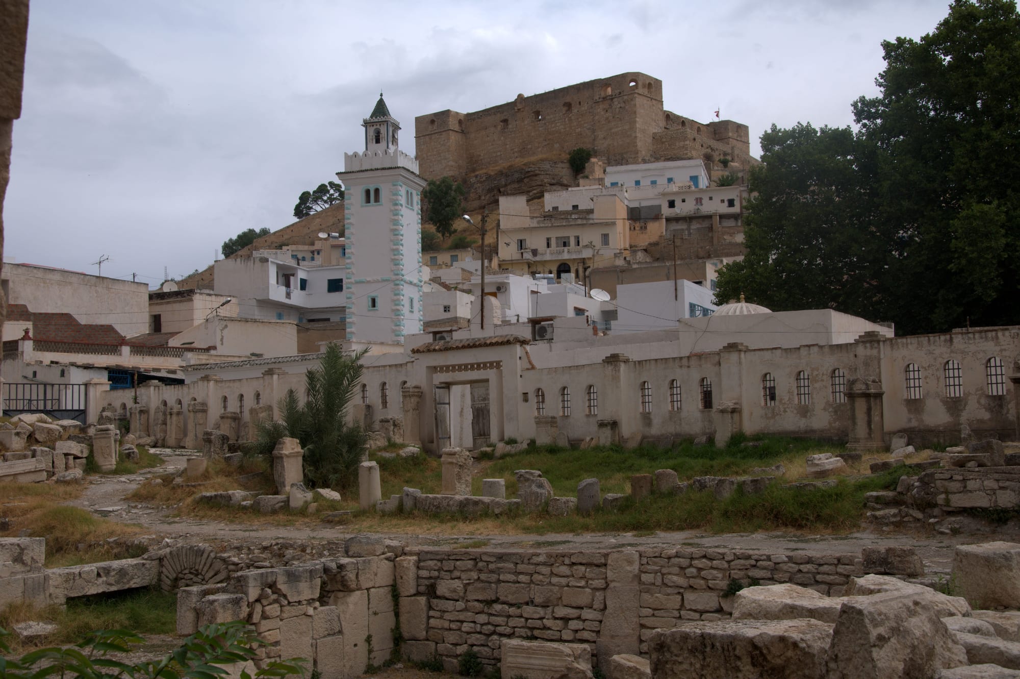
A white hill town below a stone fortress, with a tiled minaret above the roofs and Roman column bases in the foreground

The Northwest, Tunisia

El Kef

The kasbah above the old town of El Kef, seen across the Roman baths. (Alexandre Moreau / Wikimedia Commons · CC BY-SA 2.0)

A hill town in Tunisia's northwest, built on a rock spur below the Jebel Dyr escarpment and looking out over the wheat plains of the High Tell towards Algeria. Roman Sicca Veneria became an Ottoman garrison town, and its steep old quarter still climbs to a kasbah, past a domed Sufi mausoleum, a fifth-century basilica and Roman cisterns.

Neighbourhoods

  • The old town below the kasbah
    • First-time visitors
    • Historic district
    • Walks

    A steep quarter of whitewashed houses, stepped lanes and blue doors climbing to the fortress walls. The domed mausoleum of Sidi Bou Makhlouf, the old basilica, the Roman cisterns and the synagogue of the Ghriba are all within a few hundred metres of each other, and the terraces below the kasbah give the long view over the plain.

    Open in Maps
  • Place de l'Indépendance and the centre
    • Cafés
    • Close to public transport
    • Everyday life

    The lower town around the main square and Avenue Habib Bourguiba, where the banks, hotels, pastry shops and café terraces are. The louage and bus stands are close by, and the market draws people in from the surrounding villages.

    Open in Maps
  • The ramparts and the old gates
    • Views
    • Quiet and residential
    • Photography

    The eastern edge of the old town, where a surviving gate and stretches of wall look out over the escarpment. It is residential and quiet, with the ground dropping away sharply to the fields below.

    Open in Maps
  • The Jebel Dyr slopes
    • Walks
    • Countryside
    • Views

    Above the town the land rises to the flat-topped Dyr massif, with olive groves, grazing and tracks that lead to springs and viewpoints. It is a short drive or a long walk from the centre and noticeably cooler in summer.

    Open in Maps

Things to do

The old town

  • The kasbahlandmark

    The fortress on the summit, built in the 17th century to house a permanent Ottoman garrison and completed with fortified ramparts in 1740, with a small mosque, a rainwater basin and views across the High Tell.

    Open in Maps
  • Zaouia of Sidi Bou Makhlouflandmark

    The white mausoleum of the town's patron saint, held to be the founder of the Aissawa order in Tunisia, its ribbed domes and minaret standing over the square below the kasbah where the cafés look up at it.

    Open in Maps
  • Dar El Kouslandmark

    The well-preserved remains of a three-naved Christian basilica of the early fifth century, dedicated to Saint Peter, its apse still standing in the old town.

    Open in Maps
  • Roman baths and cisternslandmark

    Column bases, paving and the large stepped cisterns that supplied Sicca Veneria survive in the middle of the town, incorporated into later streets.

    Open in Maps
  • El Ghriba synagoguelandmark

    A legacy of the town's old Jewish community, venerated by Jews of the region, who come on pilgrimage each year in the week of the festival of Sukkot.

    Open in Maps
  • Museum of Popular Arts and Traditionsmuseum

    An ethnographic collection of objects used by the tribes that inhabited the Tunisian interior — weaving, jewellery and nomad equipment — housed in an 18th-century Sufi complex.

    Open in Maps

Short trips from the town

  • Douggalandmark

    A UNESCO World Heritage Site since 1997, described by UNESCO as the best-preserved Roman small town in North Africa, about 55 km north-east, with its Capitol, theatre, temples and a Libyco-Punic mausoleum.

    Open in Maps
  • Jugurtha Tablelandviewpoint

    A flat-topped mesa near Kalaat Senan, roughly 60 km south-west, reached by steps cut in the rock and named for the Numidian king said to have held out there.

    Open in Maps
  • Maktharlandmark

    A Roman town about 60 km south-east, with a triumphal arch, forum, baths and a museum, set high on the Dorsal ridge.

    Open in Maps
  • Bulla Regialandmark

    The Roman city of underground villas near Jendouba, about 45 km north-west, where mosaics survive in the rooms they were laid in.

    Open in Maps

Seasonal events

  • Spring in the High TellMarch to May

    The season of green wheat, wildflowers and weekly markets, when the Roman sites around the town are at their best and walking on the Dyr is comfortable.

  • Bou Makhlouf festivalJuly

    The town's festival, held each July and named for the patron saint whose mausoleum stands below the kasbah, with concerts and performances in the old town and at the fortress, which is often used as a festival venue.

  • Grain harvestJune

    The busiest weeks of the farming year on the plains below the town, when combines work the wheat and barley of the High Tell.

Eat and drink

Long-standing places and food districts in El Kef. Hours, ratings and directions come from your maps app, always current.

El Kef classics

  • The covered market and food streetsmarket

    Lamb, semolina, olive oil, sheep and goat cheese, honey and vegetables from the plain, with small grill shops and sandwich counters around the edges.

    Open in Maps
  • Cafés on Place Sidi Bou Makhloufneighborhood

    Terraces facing the domes of the mausoleum, serving coffee, mint tea with pine nuts and pastries, and busy from late afternoon.

    Open in Maps
  • Avenue Habib Bourguiba restaurantsneighborhood

    Plain local kitchens in the lower town doing couscous, grilled lamb and merguez, chorba soup and the fried pastry parcels called brik.

    Open in Maps

Experience El Kef

History

The rock and its spring made the site: a settlement of Phoenician origin stood here, afterwards a Numidian stronghold, and under Rome it became the colony of Sicca Veneria, marked by its worship of Venus and by the wheat of the surrounding plains. Christianity came early, and one of the chief centres of the faith in North Africa left the three-naved basilica known as Dar El Kous, built at the beginning of the fifth century and dedicated to Saint Peter. The great cisterns that stored the town's water are still visible in the streets.

After the Arab conquest the town kept its role as a frontier stronghold facing the mountains and, later, the Algerian side of the border. Its name, El Kef, simply means the rock. The Ottomans and then the Husainid beys of Tunis fortified the summit, building the kasbah in the 17th century to house a permanent garrison and completing it with fortified ramparts in 1740. Sufi lodges and the mausoleum of Sidi Bou Makhlouf gave the town a religious standing, and a Jewish community, established for centuries, lived in the quarter below.

Under the French protectorate El Kef was a military and administrative centre, and during the Second World War it served for a time as the provisional capital of Tunisia. It was a centre of nationalist and trade-union activity before independence in 1956. Since then the town has lost population and industry to Tunis and the coast, and it was one of the interior towns where protests spread in December 2010 and January 2011. Its monuments have been restored slowly, and it remains a governorate capital living largely on farming and public service.

Culture & Customs

El Kef has a reputation in Tunisia as a town of music, theatre and learning out of proportion to its size. It was a Sufi centre, with several zaouias, and the festivals around the mausoleum of Sidi Bou Makhlouf kept traditions of devotional song alive; the square in front of it is still the place where the town gathers. Amateur theatre and cultural associations have long been active, and summer brings concerts and performances to the old town and the kasbah.

The population is settled and rural in outlook, with strong family and village ties across the governorate and into Algeria, where relatives and dialects overlap. Hospitality follows the Maghrebi pattern of insistent invitations, several rounds of tea or coffee and a reluctance to let a guest leave hungry. Weddings are large, several-day affairs with drumming, ululation and processions.

Craft traditions belong to the countryside: women weave rugs, blankets and striped cloth in regional patterns, and pottery and basketry come from villages on the plain. Religious observance is mainstream and visible, with Ramadan reshaping the day and the two Eids the year's biggest family occasions. Visitors are unusual enough to be greeted and questioned kindly, and photographs of people are best taken only after asking.

Daily Life

The town had about 45,000 people at the 2004 census and is the capital of the Kef governorate, one of the least populated and poorest in Tunisia. The economy rests on wheat and barley from the surrounding plains, sheep and dairy farming, olive oil, and salaried jobs in the governorate administration, schools, hospital and university institutes. Emigration has been heavy for decades, to Tunis, to the coastal cities and to France, and many households depend partly on money sent home.

The day starts early and follows the farming and school calendar. Mornings are busiest in the lower town and at the market, the middle of the day is quiet in summer heat, and the late afternoon fills the cafés around the mausoleum square and the main avenue. The weekly market brings in villagers from across the plain, and Friday prayers empty the streets for an hour.

Unemployment among the young, the lack of industry, worn roads and a series of drought years that cut the grain harvest are the constant worries. Water supply and winter cold are recurring problems in the older houses. At the same time, restoration work in the old town, the appeal of the Roman sites nearby and a small but growing trade in guesthouses have given the place a modest tourism economy that barely existed a generation ago.

Food

The Kef kitchen is that of the wheat-growing interior: bread, semolina and lamb. Couscous, the national dish, is cooked in many forms, among them borzgane, a sweet and savoury couscous that mixes dried fruits and nuts with tender meat and is made for festive occasions and to welcome spring. Hand-rolled semolina pastas go into the winter soups, and chorba, a seasoned broth with pasta and meat, is a Ramadan fixture.

Lamb and goat are grilled as chops and as merguez sausages, and the rural tradition of drying and salting meat to keep it through the winter survives in the farming villages. Olive oil, honey from the hills, and sheep and goat cheeses come from farms around the town, while wild greens, fennel and thistle are gathered in spring. Slata mechouia, the salad of grilled peppers, tomatoes and onions dressed with oil and lemon, and brik, a crisp fried pastry parcel with egg, appear as they do everywhere in the country.

Sweets lean on dates, almonds and semolina — makroudh, ghraiba and honey-soaked pastries — and are offered with mint tea topped with pine nuts or almonds. Coffee is drunk strong and short. Thibarine, a herbal date liqueur named after Thibar in the neighbouring governorate, is the region's best-known drink of its kind.

Planning tools

Budget

El Kef is inexpensive even by Tunisian standards. A handful of small hotels and guesthouses occupy the old town and the centre, meals in local restaurants cost little, and the Roman sites charge modest entry fees. The main expense is transport, because the surrounding sites are scattered and thinly served by public transport.

Daily Budget Midrange
USD 60–130 (hotel or restored guesthouse, restaurant meals, a hired car or driver)
Daily Budget Shoestring
USD 20–35 (guesthouse or simple hotel, local food, louages)

Sharing a hired car or a driver for a day covers Dougga, the Jugurtha Tableland or Makthar far more cheaply than arranging each separately.

Best Time to Visit

March to May and September to November. Spring brings green wheat and wildflowers to the plains and mild days for climbing the old town; autumn is dry and clear. Summer is hot and dusty, though the altitude keeps nights cooler than on the coast, and winter is cold, wet and sometimes frosty, with snow on the Dyr in some years.

Suggested Number of Days

A day covers the old town at a walking pace, with a second for the museums and the ramparts. Three or four days allow the Roman sites and the tableland country to the south-west, which need a car and add long drives.

First Visit
1–2 days
With Surroundings
3–4 days

Transportation

The old town is walked; everything else is reached by road. Louages, the shared long-distance vans, run to Tunis, Jendouba, Siliana and Kasserine from the stands in the lower town, with buses on the same routes, and local taxis are cheap. Country buses to the villages are infrequent, so a hired car or a driver is the practical way to see the region.

Roads over the Dorsal ridge are narrow and can be icy or fogbound in winter; fill the tank before heading into the villages south-west of the town.

Airport & Station Connections

There is no airport or passenger railway at El Kef. Tunis is about 175 km north-east, roughly two and a half to three hours by louage or car on the road through Téboursouk, and Tunis–Carthage is the nearest international airport. Jendouba, about 60 km north-west by road, is the closest town on the railway line, and the Algerian border crossing at Sakiet Sidi Youssef is about 40 km west.

Walkability

The centre is compact but steep: the old town climbs a rock spur, and the lanes between the main square, the mausoleum and the kasbah are stepped, cobbled and sometimes slippery. Distances are short, but the gradient is constant, and the lower town along Avenue Habib Bourguiba is flatter and easier going.

Safety

The town is calm, conservative and used to few foreign visitors, and serious crime is rare. Some Western governments advise against travel to the mountainous districts along the Algerian border in the Kef and Jendouba governorates, where the security forces have operated against small armed groups; the town itself and the main roads are not part of that advice, and checkpoints are common on routes west and south.

Keep to main roads and towns near the Algerian border, travel by day, and drive carefully on the Kroumirie roads. Carry identification for the checkpoints on the routes west and south, and drink bottled water. Check current official travel advice before travelling.

Climate

A continental version of the Mediterranean climate, shaped by an altitude of 780 metres, the highest of any Tunisian city. Rain falls mainly between November and March, summers are hot and dry with cool nights, and the High Tell is one of the coldest inhabited parts of Tunisia in winter.

Summer
hot and dry, often 32–37°C by day in July and August, but noticeably cooler after dark
Winter
cold and wet, roughly 4–14°C, with frost, hail and occasional snow on the heights

Local Customs

This is a provincial, largely conservative town where visitors are noticed and usually greeted warmly. Modest dress, covering shoulders and knees, is expected in the streets and essential at the mausoleum and mosques, where shoes come off and non-Muslims may not be admitted to prayer halls. Arabic and French both work; English is limited. Alcohol is sold in very few places and is not drunk in public.

Ask before photographing people, especially women and at shrines; accept the offer of tea or coffee where it is made, and tip small amounts in restaurants and to guides.

Common Payment Methods

The currency is the Tunisian dinar, which may not legally be taken in or out of the country, so money is changed on arrival and reconverted before leaving. Cards work at hotels, banks and larger shops, but the market, cafés, taxis and louages run on cash. ATMs are in the lower town, and it is worth drawing money before heading into the villages.