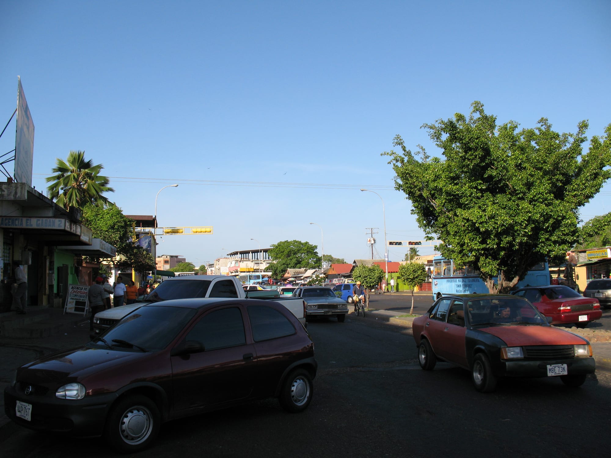
A wide street of low shops and trees under a clear blue sky, with older cars and a bus in the evening sun

Los Llanos, Venezuela

San Fernando de Apure

A street in central San Fernando de Apure. (Anagoria / Wikimedia Commons · CC BY 3.0)

The capital of Apure state, a flat river city on the wide Apure in the heart of Venezuela's llanos. Founded in 1788, it grew rich on river trade in heron feathers and hides, and is now a government, university and market town for the cattle plains, with a strong llanero culture of joropo music and coleo. This page is written to explain the city, not to encourage travel.

Neighbourhoods

  • Historic centre
    • First-time visitors
    • Historic district

    The old grid of Calle Comercio, Calle Bolívar, Calle Sucre, Calle Páez and Calle Muñoz, around the leafy Plaza Bolívar and Plaza Camejo. The cathedral, the Barbarito Palace and the Casa de Bolívar stand here.

    Open in Maps
  • The riverside
    • River views
    • Walks

    The bank of the Apure, about 300 metres wide here, where the old port once stretched for some 400 metres. Much of the former port is now dry land and streets; the María Nieves bridge of 1961 crosses the river to the south bank.

    Open in Maps
  • Biruaca and the western suburbs
    • Quiet and residential
    • Local life

    The satellite town to the west, part of a separate municipality but joined to the city along the Intercomunal avenue. It has grown faster than the city itself.

    Open in Maps

Things to do

Landmarks and museums

  • Cathedral of Our Lady of Mount Carmellandmark

    The modern cathedral, designed by a German architect and built over about ten years from 1959, and consecrated in 1969.

    Open in Maps
  • Barbarito Palacemuseum

    The Palacio de los Barbarito facing Plaza Camejo, built beside the old river port and regarded as the city's most important building, restored as a museum with its original mosaics.

    Open in Maps
  • Casa de Bolívarlandmark

    An 18th-century armoury at Calle Comercio and Calle Independencia, a national historic monument restored in 1983, now holding a public library and the municipality's cultural offices.

    Open in Maps
  • Plaza Bolívarpark

    The city's leafy central square, laid out at the founding of the town in 1788.

    Open in Maps

The river

  • Apure riverfront and the María Nieves bridgeviewpoint

    The broad brown Apure, a major tributary of the Orinoco, seen from the riverside and from the bridge opened in 1961.

    Open in Maps
  • Las Flecheras Airporttransit hub

    The city's airport, with its runway just east of the city along the Apure river.

    Open in Maps

Llanero sport

  • Vuelvan Caras coleo arenaattraction

    The coleo ground in the José Antonio Páez fairground on the west side of the city, where national and regional tournaments of the llanero bull-tailing sport are held.

    Open in Maps

Eat and drink

Long-standing places and food districts in San Fernando de Apure. Hours, ratings and directions come from your maps app, always current.

Food districts

  • The historic centreneighborhood

    The streets around Plaza Bolívar and Calle Comercio, with simple places to eat serving everyday llanero food.

    Open in Maps
  • Paseo Libertadorneighborhood

    The city's best-known avenue, running in a straight line from north to south with a boulevard, crossed by the main east–west avenues.

    Open in Maps

Experience San Fernando de Apure

History

San Fernando was founded on 28 February 1788 on the orders of Fernando Miyares y González, governor of the newly formed Province of Barinas, in a ceremony witnessed by about 200 indigenous people. A main square, now Plaza Bolívar, was marked out and a cross set where the church would stand. Its position on the Apure gave it importance in controlling the plains, and in its early trade it exported heron feathers, used for pens, and animal hides. Alexander von Humboldt stayed for a few days in March 1800.

In the independence war the plains of Apure were the territory of José Antonio Páez, whose lancers won the battle of Las Queseras del Medio in the state in 1819. During the Federal War, on 21 June 1859, much of the town was burned. By the early 20th century San Fernando was a busy river port, with factories for pasta, canned food and candles and a trade in heron feathers and alligator skins shipped to Europe; the Barbarito Palace was built by the port in this period. The trade declined as demand fell and railways and roads replaced river navigation.

A catastrophic flood in 1916 led to the opening of a diversion canal in 1917, and the María Nieves bridge across the Apure opened in 1961. The cathedral was consecrated in 1969, the diocese was created in 1974, and universities arrived from 1976; the city now has many schools and several universities.

Culture & Customs

San Fernando is the main river town of the southern plains, and the plains' culture shapes its identity. Joropo, played on harp or bandola, cuatro and maracas, is danced at events across the city and especially in its outer districts, and singers keep up the contrapunteo, the improvised duel of verses. Coleo, in which riders chase a bull and topple it by the tail, is the city's signature sport, with national and regional tournaments held at the Vuelvan Caras arena in the fairground on the west side.

The river is part of local life and pride. San Fernando is the starting point of long-distance river events that finish in Ciudad Guayana; one of them follows a route of about 2,000 kilometres along the Apure, the Orinoco and other rivers of the plains and Guayana.

Lifestyles differ by age and district: many older residents keep traditional llanero customs, while young people in the city lean towards the styles of Caracas and North America. The plains' oral tradition of ghost stories, such as La Sayona and El Silbón, and the novel "Doña Bárbara", set in Apure, are part of the shared culture. The Juan Lovera School of Plastic Arts, founded in 1964, trains local artists.

Daily Life

The municipality of San Fernando had about 165,000 people at the 2011 census. The built-up area spreads across both banks of the Apure and has merged with the satellite town of Biruaca to the west and the parish of El Recreo to the east. The ground is so damp that buildings of more than five storeys are not permitted, giving the city a flat, low skyline.

As the state capital, the city lives from government, education, health care, banking and commerce, serving a wide area of cattle ranches and river villages. Several universities have campuses here, among them UNELLEZ, the national experimental university of the western plains, and the Simón Rodríguez university.

The national crisis has hit hard: fuel shortages stop trucks and tractors, power cuts are long, and many young people have left. The presence of armed groups and smugglers shapes life near the Colombian border, far to the west. Days begin early, before the heat, and slow down at midday.

Food

Beef is the centre of the llanero table. Carne en vara is beef skewered on stakes around an open fire and roasted slowly. Pisillo is shredded, salted and sun-dried meat or fish, fried with garlic and sweet peppers, and it is also made with chigüire, the capybara, whose meat is traditionally eaten during Lent and Holy Week.

The plains produce much of Venezuela's cheese, and soft fresh cheeses such as queso de mano, a stretched curd cheese, are eaten with cachapas, sweet fresh-corn pancakes. The Apure and the other rivers supply fish, fried or stewed.

The everyday national dishes — arepas, empanadas and pabellón criollo, the plate of shredded beef, black beans, rice and fried plantain — are found everywhere. Coffee is drunk strong and black through the day, and sweets are made from milk and papelón, the raw cane sugar of the region, which also makes papelón con limón, a sweet lemon drink.

Planning tools

Budget

The city itself is inexpensive for anyone carrying US dollars in cash, with simple hotels and local food. Wildlife visits to the plains are the main cost: they mean staying on a ranch with full board and guided excursions, priced in dollars, and private transport to reach it.

Daily Budget Midrange
USD 120–250 (ranch lodge with full board, guided wildlife trips and transfers)
Daily Budget Shoestring
USD 30–60 (simple hotel, local food, shared transport where running)

Arrange ranch stays and transfers together through the lodge or an established operator, and bring US dollar cash for the whole trip.

Best Time to Visit

The dry season, especially January to April, is best for wildlife on the surrounding plains, when animals gather at the remaining water and roads are passable. From about May to October heavy rains flood huge areas of Apure. Security matters more than the season.

Suggested Number of Days

The city itself needs a day or two at most. Most visitors who come this far use it as a base for the plains, and a stay on a working ranch for wildlife adds three or four days; wet-season flooding can lengthen any trip.

First Visit
1–2 days
With Surroundings
4–5 days

Transportation

The city is flat and spread out, joined to Biruaca in the west by long avenues. Taxis and local buses cover it. Beyond the city, roads cross the open plains to Achaguas in the west and San Juan de Payara and Puerto Páez in the south; many dirt roads close when the plains flood.

Travel with a driver arranged by the lodge, move only in daylight, and expect flood closures between May and October.

Airport & Station Connections

San Fernando is reached by road from Caracas through San Juan de los Morros, most of a day's drive. Las Flecheras Airport, just east of the city along the Apure, serves the city, but flights are scarce. Most international arrivals come through Maiquetía, which was heavily damaged by the earthquakes of 24 June 2026 and reopened at about half capacity in August 2026.

Walkability

The historic centre is flat and compact, with the cathedral, the main squares and the Barbarito Palace within a few blocks. The heat makes midday walking hard, and the outer districts and Biruaca need a taxi.

Safety

Apure's border with Colombia, well to the west and south of the city, is one of the most dangerous areas in Venezuela, with Colombian guerrilla and dissident groups operating there. Rural roads across the plains are isolated, with little medical care, and fuel shortages are common.

Most governments advise against all or all-but-essential travel. Anyone who does go should stay well away from the Colombian border, travel only in daylight with trusted drivers, and keep to established ranches. Check current official travel advice before travelling.

Climate

A tropical monsoon climate with an annual average of about 28°C and high humidity beside the river. The year divides sharply into a wet season, when the surrounding plains flood, and a hot, dry season.

Summer
the wet season, May to October: hot and humid, 24–33°C, with floods and mosquitoes
Winter
the dry season, December to April: very hot, often above 35°C by day, dusty and sunny

Local Customs

San Fernando is a llanero city: joropo music and dance are popular, especially on the outskirts, and coleo draws crowds to the arena. Older residents keep traditional plains customs, while younger people in the city follow styles from Caracas and abroad.

Greet people before asking for anything, dress modestly in the cathedral, and never photograph security forces, checkpoints or military installations.

Common Payment Methods

The currency is the bolívar, but US dollars in cash are used in practice, and card and ATM access for foreigners barely works. Carry enough cash in small notes for the whole stay, including any ranch visit.