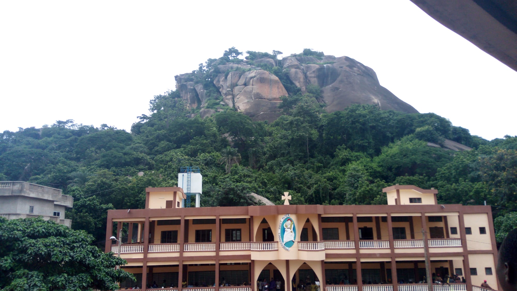
A long two-storey pilgrimage building with arched galleries below a wooded granite dome under a pale sky

Abomey & the Centre, Benin

Dassa-Zoumè

The Marian sanctuary of Notre-Dame d'Arigbo below one of the granite hills of Dassa-Zoumè. (Chedwiki / Wikimedia Commons · CC BY-SA 3.0)

A town in the Collines department of central Benin, set among bare granite domes on the highway and railway line north from Cotonou. It grew as the seat of the Yoruba-speaking Idaasha, whose country the Kingdom of Dahomey raided for captives, and is now known across the country for the Marian grotto that draws pilgrims each August.

Neighbourhoods

  • The centre and the market
    • First-time visitors
    • Markets
    • Close to public transport

    The commercial heart of the town, strung along the main highway where coaches and bush taxis stop. Shops, banking agents, stalls of yams and charcoal and the small hotels are all within a few streets of each other, and motorcycle taxis wait at every junction.

    Open in Maps
  • Arigbo and the sanctuary quarter
    • Pilgrims
    • Quiet and residential
    • Walks

    The quarter below the pilgrimage hill, dominated by the Marian sanctuary and its terraces of steps. It is calm for most of the year and turns into a temporary city of tents, coaches and food stalls in August.

    Open in Maps
  • The station quarter
    • Local life
    • Quiet and residential

    The area around the old railway station on the Cotonou line, with low compounds, workshops and depots behind the tracks. It is the ordinary working side of the town, largely untouched by pilgrimage traffic.

    Open in Maps
  • The outlying hill villages
    • Countryside
    • Walks and viewpoints

    Farming hamlets scattered through the commune between the granite domes, growing yams, maize and cashew. Footpaths climb between fields and bare rock, and the views back over the savanna are the reason most visitors walk out this far.

    Open in Maps

Things to do

The hills and the sanctuary

  • Grotto of Notre-Dame d'Arigbolandmark

    A Marian grotto at the foot of a granite hill, where the Virgin Mary is said to have appeared and a basilica containing several shrines has since been built.

    Open in Maps
  • The Collines granite domesviewpoint

    Bare rounded inselbergs rising straight out of the savanna around the town, many of them wooded and holding Orisa shrines, with paths to the tops.

    Open in Maps
  • The calvary and stations of the crossattraction

    A hillside route of shrines above the sanctuary, walked by pilgrims and used for ceremonies during Holy Week.

    Open in Maps

In the town

  • Dassa-Zoumè marketmarket

    The town's main market, selling yams, maize, groundnuts, palm oil, cloth and fried snacks, busiest on its day in the rotating regional cycle.

    Open in Maps
  • Dassa-Zoumè railway stationtransit hub

    A station on the colonial-era line from Cotonou to Parakou, which no longer carries regular passenger services but still marks the town's place on the north–south axis.

    Open in Maps

Short trips from the town

  • Glazouéattraction

    A market town north along the highway, at the centre of a farming district of maize, cashew and yams.

    Open in Maps
  • Savèattraction

    A town below a line of steep granite hills, long a crossing point on the route towards the Nigerian border.

    Open in Maps
  • Savalouattraction

    The seat of an old Mahi dynasty in the western Collines, known for its yam festival on 15 August.

    Open in Maps
  • Royal Palaces of Abomeylandmark

    The earthen palace compounds of the Dahomey kings, with painted bas-reliefs, thrones and appliqué banners in the museum.

    Open in Maps

Seasonal events

  • Pilgrimage to Notre-Dame d'ArigboAugust

    Tens of thousands of Catholic pilgrims converge on the grotto in mid-August, filling the town with processions, night vigils and coaches from across Benin and beyond.

  • Holy Week ceremoniesMarch or April

    Processions and services at the sanctuary and along the hillside stations of the cross, the second busiest moment of the religious year.

  • National Vodun DayJanuary

    A public holiday on 10 January marked throughout Benin, though the largest ceremonies are held on the coast at Ouidah rather than in the Collines.

Eat and drink

Long-standing places and food districts in Dassa-Zoumè. Hours, ratings and directions come from your maps app, always current.

Dassa classics

  • Pounded yam stallsrestaurant

    Yam from the surrounding farms boiled and beaten into igname pilée, a smooth elastic dough eaten with peanut, tomato or leafy-green sauce.

    Open in Maps
  • Roadside grills on the highwayrestaurant

    Charcoal grills near the coach stops selling chicken, mutton and fried slices of wagasi, the soft cow's-milk cheese of northern Benin, with chilli and onion.

    Open in Maps
  • Maquis in the centrerestaurant

    Open-air bar-restaurants serving rice, amiwo maize dough with chicken, beer and soft drinks in the evening.

    Open in Maps

Markets and street food

  • Dassa-Zoumè marketmarket

    Heaps of yams and maize, palm oil, smoked fish brought up from the coast, and women frying akara bean fritters and kuli-kuli peanut sticks at the edges.

    Open in Maps
  • Fruit and cashew stallsmarket

    Stands along the highway selling oranges, pineapples, mangoes in season and roasted cashew nuts to passing drivers.

    Open in Maps

Experience Dassa-Zoumè

History

The hills above the plain gave this place its history. Tradition among the Idaasha, a Yoruba-speaking people, traces their ruling line to migrants from the Egba country of western Yorubaland, in what is now Nigeria, who settled among the granite domes, where the rock offered shelter and a lookout. The name joins two old settlements, Dassa and Zoumè, and the earliest quarters grew at the foot of the inselbergs rather than on the open savanna around them.

That choice mattered from the seventeenth century onwards, when the Kingdom of Dahomey, expanding north from Abomey, raided the peoples of the middle belt for captives to sell at the coast. The Idaasha and the neighbouring Mahi are said to have used the caves, clefts and steep slopes as refuges, and the hills are still pointed out as hiding places. Dahomey pressed repeatedly into the region without absorbing it completely, and the French conquest of the 1890s ended the raiding by bringing the whole area under one colonial administration.

Colonial rule reoriented the town towards the north–south axis. The railway from Cotonou reached the Collines early in the twentieth century and the road followed it, turning Dassa-Zoumè into a staging point for yams, cotton and groundnuts moving south. Catholic missionaries arrived in the same period, and the development of the Marian grotto at Arigbo eventually made a provincial market town into a place of national pilgrimage. The Collines department was created in 1999, when Benin reorganised its provinces, and Dassa-Zoumè replaced Savalou as its administrative seat in 2016.

Culture & Customs

Dassa-Zoumè is Yoruba country at its western edge. Idaasha, close to the Yoruba spoken across the border in Nigeria, is the language of the market and the compound, with French used in school and administration and Fon and Mahi heard from neighbours to the south and west. Praise names, drumming and the authority of family heads and traditional rulers remain part of public life, and Egungun masqueraders, ancestral spirits in layered cloth, appear at funerals and festivals as they do elsewhere in Yoruba country.

What sets the town apart is the weight of Catholicism laid over that older culture. The sanctuary of Notre-Dame d'Arigbo draws tens of thousands of pilgrims each mid-August, when coaches arrive from Cotonou, Porto-Novo and beyond and the hillside fills with candles, hymns in several languages and all-night vigils. Islam has a long presence through trading families, and Vodun shrines stand in the quarters and the villages, so it is common for one family to take part in more than one tradition.

The farming year gives the other rhythm. New yams are not eaten until the harvest is formally opened, a rule kept across the Collines and celebrated with the yam festivals of neighbouring towns in August, and the rotating markets of the hill country still set the pattern of the week.

Daily Life

The commune of Dassa-Zoumè had about 112,000 people at the 2013 census, most of them in villages and hamlets rather than the town itself, which is modest in scale and low in build. Its position on the main highway and the railway gives it more movement than its size suggests: coaches stop, traders load yams for the southern markets, and lorries heading for Parakou and Niger pass through day and night.

Farming is the foundation. Yams are the prestige crop and the one the Collines are known for, grown alongside maize, cassava, groundnuts, beans and increasingly cashew, whose nuts are dried and sold on for export. Cotton is grown on some of the surrounding land. Beyond agriculture, work means small trade, transport, teaching and administration, since the town is a departmental seat, with the pilgrimage supporting hotels, food sellers and craft stalls for part of the year.

The day starts early and pauses in the afternoon heat. Water and electricity can be unreliable in the outer quarters, and many households depend on money sent home by relatives working in Cotonou or abroad. Young people leave for the coast for schooling and work, and return for funerals, harvests and the August pilgrimage, which is when the town is fullest and the compounds most crowded.

Food

The Collines are yam country, and igname pilée is the dish of the town: boiled yam pounded in a wooden mortar into a smooth, stretchy dough, torn by hand and dipped into a sauce of groundnut, tomato and meat, or dark leafy greens. In the drier months yam is also dried and ground into flour to make télibo, a stiff brown paste with a distinctive sour note. Maize dough — plain white akassa or the red, palm-oil-coloured amiwo — is the everyday alternative, usually with a peppery tomato sauce and smoked fish brought up from the lagoons.

Wagasi, the soft cow's-milk cheese common across northern Benin, is sold in pale discs and fried in slices until it squeaks, either as a snack or stirred into sauce. Roadside grills do chicken and mutton, and bush meat such as grilled agouti appears in season. Fermented néré seeds, afitin, give many sauces their pungent depth, and groundnuts are roasted or pressed into kuli-kuli, crisp fried sticks of peanut paste.

For drinking there is palm wine, tapped and drunk fresh, and sodabi, the strong spirit distilled from it, alongside bissap made from hibiscus, ginger juice and bottled beer in the maquis. Roadside stalls sell oranges, pineapples and mangoes in season, and the cashew harvest brings both nuts and the sharp juice of the cashew apple.

Planning tools

Budget

Dassa-Zoumè is inexpensive. Hotels are simple and cheap, market and maquis meals cost very little, and bush taxis along the highway are the cheapest way to arrive. Costs rise only for a hired car with driver, which is how most visitors reach the hill villages and the neighbouring towns, and in August, when pilgrimage demand strips the town of rooms.

Daily Budget Midrange
USD 60–140 (best local hotel, restaurant meals, a guide for the hills, a car with driver)
Daily Budget Shoestring
USD 20–45 (basic hotel or guesthouse, market food, bush taxis and motorcycle taxis)

Bring cash from Cotonou or Bohicon; card payment is rare in the Collines and cash machines are few.

Best Time to Visit

November to February is the most comfortable season, dry and a little cooler, though the Harmattan leaves the hills hazy. March and April are very hot, and the rains from about May to October make farm tracks difficult. Mid-August is the pilgrimage, which is the town at its most remarkable and its most crowded.

Suggested Number of Days

Most visits last a single day, which covers the town, the sanctuary and a climb on one of the hills. Two days suit anyone adding the hill villages or a neighbouring Collines town. The August pilgrimage, or walking in the countryside, stretches a stay further.

First Visit
1 day
With Surroundings
2 days

Transportation

Everything in the centre is within walking distance, and zémidjan motorcycle taxis cover longer hops, including the ride up to the sanctuary and out to the villages. There are no scheduled town buses. Bush taxis and long-distance coaches use the highway through the town, and a hired car with driver is the practical way to reach the hills and nearby towns.

Agree the fare with a motorcycle-taxi rider before setting off, and avoid road travel after dark on the busy highway.

Airport & Station Connections

The town sits on the paved highway between Cotonou and Parakou, roughly three to four hours north of Cotonou by road and about an hour beyond Bohicon, the junction for Abomey. Coaches and bush taxis running north stop here, and the railway line through the town no longer carries regular passengers. The nearest international airport is at Cotonou.

Walkability

The centre is flat, compact and easily walked, though the highway traffic is heavy and pavements are patchy. The sanctuary and the hills are a short ride or a warm walk from the middle of town, and the paths up the granite domes are steep and unshaded, best taken early in the day. Distances between quarters are short.

Safety

The Collines lie well south of the areas affected by Benin's northern insurgency, and the town is generally calm. Road accidents on the Cotonou–Parakou highway are the main danger, along with petty theft at the coach stops and in the market, and crowding during the August pilgrimage.

Most governments advise against all or all-but-essential travel to the northern departments and the parks; the Collines are far to the south of those areas. Avoid road travel after dark, keep valuables close at bus stations and in pilgrimage crowds, and ask before photographing shrines, ceremonies or worshippers. Check current official travel advice before travelling.

Climate

A transition climate between the two-season south and the single wet season of the north, drier and less humid than Cotonou and hotter by day in the dry months. Rain falls mainly between about April and October, and the Harmattan brings dust and haze from December to February.

Summer
the wet months, roughly 24–31°C, with heavy afternoon storms and green hills
Winter
dry and hot, 30–35°C by day with cooler nights, dusty and hazy in the Harmattan

Local Customs

This is a religiously mixed town where Catholicism, Islam and Vodun sit side by side, and respect at the sanctuary matters: modest dress, quiet during services, and no photography of worshippers without asking. Greetings are unhurried and handshakes usual. Vodun shrines and convents in the surrounding villages have their own rules on entry and should only be approached with a local guide.

Tipping is not expected, though small sums for guides are welcome; dress modestly at the sanctuary and in villages, and ask before taking photographs of people, shrines or ceremonies.

Common Payment Methods

The currency is the West African CFA franc, pegged to the euro. Cash rules: almost nothing in the town takes cards, and travellers usually draw money in Bohicon, Parakou or Cotonou before arriving. Mobile money agents are common for local transfers, and small notes are useful for markets and motorcycle taxis.