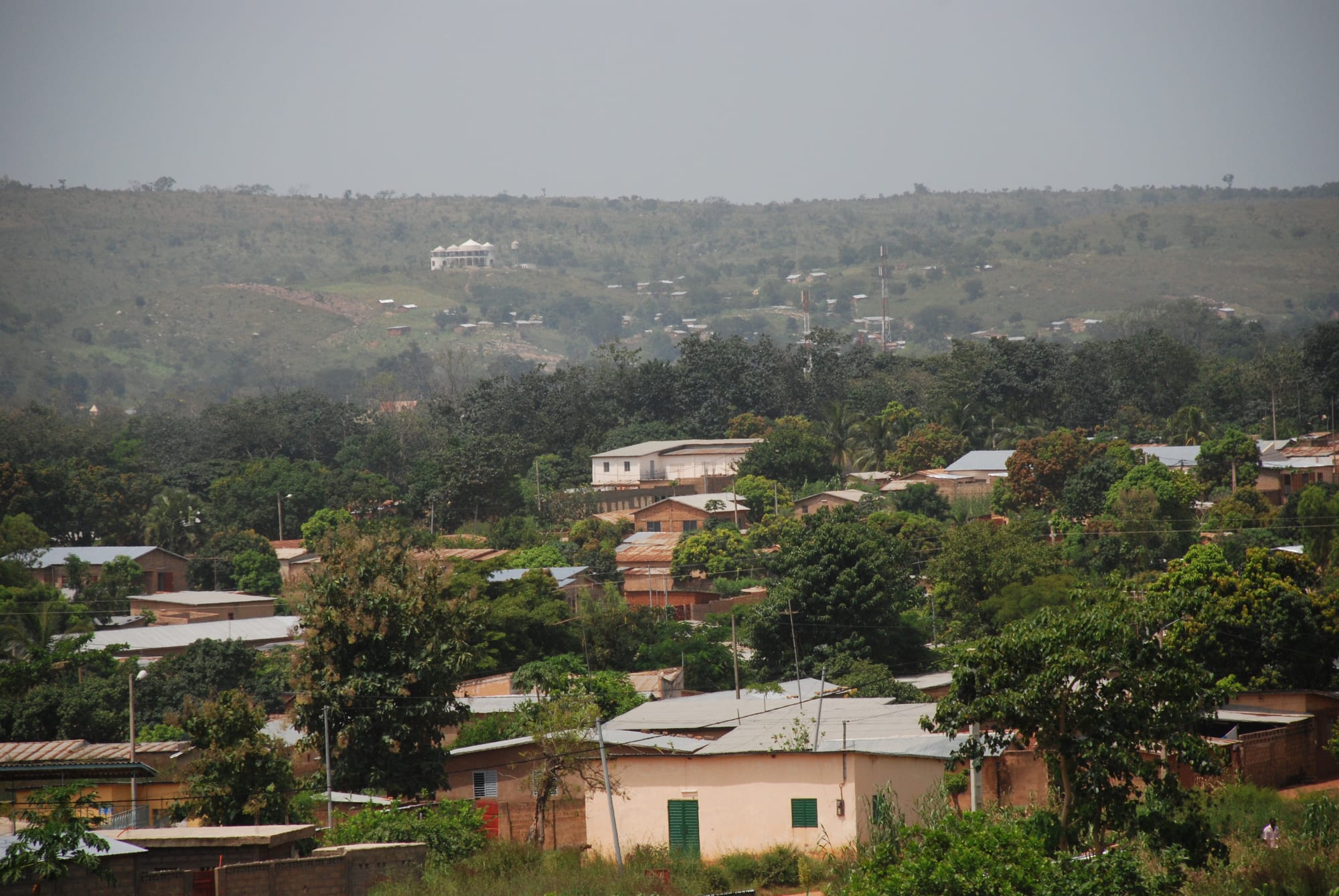
A low town of tin-roofed houses among dense trees, with wooded hills rising behind under a hazy sky

Natitingou, Pendjari & the North, Benin

Natitingou

Natitingou spread through its valley below the slopes of the Atacora range in north-western Benin. (Baliola / Wikimedia Commons · CC BY-SA 3.0)

The capital of Benin's Atacora department, spread through a valley of the Atacora range in the north-west of the country. A colonial administrative post that grew into a hill town of markets, schools and offices, it long served as the base for visits to the Betammaribe tower-houses and the Pendjari savanna, a role the region's security crisis has largely suspended.

Neighbourhoods

  • The centre and the main road
    • First-time visitors
    • Markets
    • Close to public transport

    The strip along the road through town where the banks, offices, shops and coach agencies stand, with the market a short walk away. Most hotels and eating places are here, and motorcycle taxis gather at the junctions.

    Open in Maps
  • The museum quarter
    • Museums
    • Walks

    The area holding the regional museum on the town's higher ground. It is quieter than the market end, with wide plots, schools and administrative buildings between the trees.

    Open in Maps
  • The upper slopes
    • Quiet and residential
    • Views

    Compounds climbing the valley sides above the centre, where the streets turn to red earth and the town thins into gardens and fields. The views over the roofs towards the Atacora ridges are the best in town.

    Open in Maps
  • The outskirts towards Boukoumbé
    • Countryside
    • Local life

    The western edge, where the road leaves for the Somba country. Farmsteads, granaries and the first tata houses appear within a few kilometres, and the change from town to hill village is quick.

    Open in Maps

Things to do

Museums and the town

  • Musée régional de Natitingoumuseum

    The regional museum of popular arts and traditions, explaining the architecture of the tata houses, the crafts and the history of the Atacora peoples.

    Open in Maps
  • Stèle de Kabalandmark

    A memorial to Kaba, who led the Atacora revolt against French conscription in 1916 and 1917, a rising that was put down by force.

    Open in Maps
  • Natitingou marketmarket

    The town's market, selling yams, millet, shea butter, wagasi cheese, cloth and household goods, and the place where hill villages come to trade.

    Open in Maps

Hills and water

  • Kota Fallsattraction

    A waterfall dropping over rock ledges into a pool in wooded country a short drive from the town, the closest of the Atacora cascades.

    Open in Maps
  • The Atacora ridgesviewpoint

    The range of quartzite ridges and valleys that the town sits in, crossed by footpaths between farms and giving long views over the savanna.

    Open in Maps

Short trips from the town

  • Boukoumbéattraction

    A hill town among the fields of the Betammaribe, with a large market and fortified earthen houses in the surrounding countryside.

    Open in Maps
  • Koussoukoingouattraction

    A village of tata houses standing on a ridge among rocks and fields, one of the best known of the Betammaribe villages.

    Open in Maps
  • Koutammakouattraction

    The landscape of Batammariba tower-houses first listed by UNESCO on the Togolese side, which became a cross-border World Heritage Site in 2023 when sites in Benin were added.

    Open in Maps
  • Tanougou Fallsattraction

    A series of cascades falling from the Atacora escarpment into pools below, near the town of Tanguiéta.

    Open in Maps
  • Pendjari National Parkpark

    Savanna and river country sheltering some of West Africa's last lions, elephants and buffalo, and part of the W-Arly-Pendjari UNESCO World Heritage Site; both parks have been hit by attacks and are largely closed, and any visit depends entirely on current security advice.

    Open in Maps

Seasonal events

  • Betammaribe initiation ceremoniesdry season

    Ceremonies marking the passage of young men and women to adulthood, held in the Atacora villages around the town and central to local life rather than staged for visitors.

  • The new yam seasonAugust and September

    The harvest of new yams, marked with family meals and village ceremonies across the Atacora before the crop is eaten freely.

  • National Vodun DayJanuary

    A public holiday on 10 January observed throughout Benin, though the great ceremonies take place on the southern coast rather than in the north.

Eat and drink

Long-standing places and food districts in Natitingou. Hours, ratings and directions come from your maps app, always current.

Natitingou classics

  • Pounded yam kitchensrestaurant

    Small eating houses serving igname pilée, yam beaten into a smooth dough, with peanut, tomato or leafy-green sauce and a little meat.

    Open in Maps
  • Maquis and grills in the centrerestaurant

    Open-air places along the main road grilling chicken and mutton over charcoal and serving rice, beer and soft drinks in the evening.

    Open in Maps

Markets and street food

  • Natitingou marketmarket

    Yams, millet, sorghum, dried fish, shea butter, kilishi dried meat and discs of wagasi cheese, with women frying akara bean fritters at the edges.

    Open in Maps
  • Tchoukoutou courtyardscafe

    Courtyard cabarets where women brew and serve tchoukoutou, the cloudy millet beer of the Atacora, drunk from calabashes.

    Open in Maps

Experience Natitingou

History

The Betammaribe and neighbouring peoples of the Atacora lived for centuries in scattered fortified homesteads without kings, each household defending itself from a two-storey earthen tower-house. The hills gave protection from the horsemen of the Bariba kingdoms to the east and from the slave raiding that reached deep into the region, and there was no town here in the sense the word usually carries — only farms, granaries and shrines spread through the valleys.

Natitingou itself is a colonial creation. The French, who took control of the region in the 1890s, chose the valley as an administrative post for the north-west, and a market, mission and school gathered around it. Colonial demands fell heavily on the Atacora, above all conscription during the First World War, which provoked the revolt led by Kaba in 1916 and 1917; it was put down by force and is commemorated by a stele in the town. Missionary schooling, unusually strong here, later gave the district an influence out of proportion to its size.

After independence the town became the capital of Atacora department and the home of a northern political class — Mathieu Kérékou, who ruled Benin for most of the period between 1972 and 2006, came from this district. From the 1990s Natitingou also became the gateway to Pendjari, with hotels and guides serving travellers heading for the park and the Somba country. That trade ended abruptly when armed groups from the Sahel began attacking across the northern border from around 2021, leaving the town with its administration, schools and markets but very few visitors.

Culture & Customs

The town is the meeting point of the Atacora's peoples. Ditammari is widely spoken alongside French, with Waama, Fulfulde and Dendi heard in the market and Bariba traders from the east. The Betammaribe — often called Somba, a name outsiders gave them — are known above all for the tata, a round two-storey house of earth and wood with a flat roof terrace and conical granaries, built for defence and for household ritual, with the ground floor for animals and the terrace for sleeping, drying grain and offerings. The Batammariba landscape of Koutammakou, inscribed by UNESCO on the Togolese side, became a cross-border World Heritage Site in 2023 when sites in Benin were added.

Initiation remains the central institution of village life. Ceremonies marking the passage of young men and women to adulthood involve seclusion, instruction, scarification in some families, and public dancing that brings whole valleys together in the dry season. Funerals are long and musical, with drums, horns and dances that can last days.

Christianity is strong in the town, the fruit of a century of mission schools, and Islam is as strongly present — the town is close to evenly divided between the two — but neither has displaced the household shrines at the door of the tata or the diviners consulted before planting, building and marriage. The town's museum exists partly to explain this to outsiders, and local guides from the villages have long done the same work in person.

Daily Life

About 104,000 people lived in the commune at the 2013 census, a good share of them in the villages rather than the town, which stretches along its valley road in low compounds under tin and thatch. It is a departmental capital, so government offices, secondary schools, a hospital and the army give it a salaried class that most northern towns lack, and market days bring in farmers from the hills.

Farming shapes everything else. Yams, sorghum, millet, maize and beans are grown on the slopes, women gather shea nuts and press them into butter, and cotton is grown on flatter land to the east. Cattle belonging to Fulani herders move through the valleys, sometimes into conflict with farmers over fields and water. Remittances from relatives in Cotonou and abroad matter to many households, and young people leave for the coast for work and schooling.

The security crisis on the northern border has changed the town's mood and economy. Soldiers and displaced families have arrived, tourism — once a real source of income for hotels, drivers and village guides — has almost stopped, and journeys towards the parks or the Burkinabè border have become a matter of official permission rather than choice. Daily life otherwise keeps its rhythm: early market, a long pause in the afternoon heat, and evenings in the maquis or the courtyard.

Food

Yam is the foundation. Boiled and beaten in a wooden mortar, it becomes igname pilée, a smooth elastic dough eaten by hand with a sauce of groundnut, tomato or dark leaves, and dried yam is ground into flour for télibo. Where the rains are thinner, millet and sorghum are cooked into tô, a stiff porridge served with okra, baobab-leaf or soumbala sauce — the last made from fermented néré seeds, pungent and deeply savoury, which northern cooks use as others use stock.

The Atacora's own products fill the market. Shea butter, made by women from gathered nuts, is used for frying as well as for skin; wagasi, the soft cow's-milk cheese of northern Benin, is sold in pale discs and fried until it browns; and kilishi, thin spiced dried meat of Hausa origin, is sold in sheets. Grilled chicken and mutton are the standard evening food along the main road, with chilli, onion and sometimes fried yam chips.

The traditional drink is tchoukoutou, a cloudy beer brewed from millet or sorghum by women and served warm in calabashes in courtyard cabarets, a social institution as much as a drink in the non-Muslim villages. Alongside it come bissap made from hibiscus, ginger juice, sweetened milk in Muslim households, and bottled beer and soft drinks in the town's maquis.

Planning tools

Budget

Natitingou is cheap by any measure. Hotels are simple, market food and grills cost little, and bush taxis are the standard way to arrive. The expensive part of a northern trip was always the park, with fees, lodges and a four-wheel drive, and park tourism has largely halted. A hired car with driver is now the main cost for anyone wanting to reach the hill villages and waterfalls.

Daily Budget Midrange
USD 70–160 (best hotel in town, restaurant meals, a guide, a car with driver)
Daily Budget Shoestring
USD 20–45 (basic hotel, market food, bush taxis and motorcycle taxis)

Draw cash in Parakou or Cotonou before coming north; cash machines are few and cards are rarely accepted.

Best Time to Visit

November to February is the most comfortable season, dry with cool nights, though the Harmattan fills the air with dust and haze. March to May is fiercely hot, and the rains from about June to September green the hills but make dirt roads to villages and falls difficult. Security, not weather, decides whether a visit makes sense at all.

Suggested Number of Days

A day or two covers the town itself and its museum. Three or four suit the Somba villages, the waterfalls and the wider Atacora, where distances on poor roads eat the time. How much is reachable depends far more on the security situation than on the length of a stay.

First Visit
1–2 days
With Surroundings
3–4 days

Transportation

The town is small enough to cross on foot, and zémidjan motorcycle taxis handle everything else, including rides out to nearby villages. Bush taxis and coaches use the main road for Djougou, Parakou and Cotonou, and minibuses run west towards Boukoumbé and north to Tanguiéta. Unpaved roads into the hills need a sturdy vehicle, and a hired car with driver is the usual arrangement.

Travel only in daylight, follow local advice on which roads are open, and agree fares with motorcycle-taxi riders in advance.

Airport & Station Connections

Natitingou lies on the road that runs through Djougou from the main Cotonou–Parakou highway and on north towards Tanguiéta, roughly ten hours from Cotonou by coach and about four to five from Parakou. Coaches run daily from the coast, and bush taxis link the northern towns. The nearest international airport is at Cotonou; there are no scheduled flights to the north.

Walkability

The centre is easily walked, though the town is strung along its main road and the ground rises steeply towards the upper quarters, so walks between the market, the museums and the higher compounds are longer than they look. Pavements are patchy and there is little shade in the middle of the day. Everything beyond the town needs a vehicle.

Safety

Northern Benin is where the country's serious security problem lies. Since around 2021 armed groups active in Burkina Faso and Niger have attacked army posts, rangers and villages in and around the Pendjari and W national parks and along the Atacora and Alibori borders, and two French tourists were kidnapped in Pendjari in 2019. Natitingou itself is a garrison and administrative town, calmer than the border zone, but it sits close to it.

Most governments advise against all travel to the parks and the northern border areas and against all but essential travel to much of the rest of the north. Do not attempt the parks or border roads, travel only in daylight, and do not photograph soldiers, checkpoints or government buildings. Check current official travel advice before travelling.

Climate

A single rainy season, from about May or June to September, is followed by a long dry season. The Atacora hills are a little cooler than the plains of the north-east, and the Harmattan blows dust and haze across the town from roughly December to February, leaving cold nights and warm days.

Summer
the rainy season, roughly 24–32°C, with storms that cut dirt roads and turn the hills green
Winter
dry and dusty, around 30–35°C by day with cool nights; very hot from March to May

Local Customs

The Atacora is religiously mixed, with Christianity, Islam and older Betammaribe practice side by side. Tata houses are homes and ritual spaces, not exhibits: entry and photography are asked for and usually paid for, and a village guide is the normal way to visit. Greetings are long, elders are addressed first, and initiation ceremonies are private unless a family invites a visitor.

Ask before photographing people, houses or shrines, dress modestly in villages, and agree with a guide in advance what a village visit will cost.

Common Payment Methods

The currency is the West African CFA franc, pegged to the euro. Cash is what works: a handful of bank branches and machines serve the town, card payment is rare, and villages deal only in notes and coins. Mobile money agents handle local transfers, and small change is needed for motorcycle taxis and market stalls.