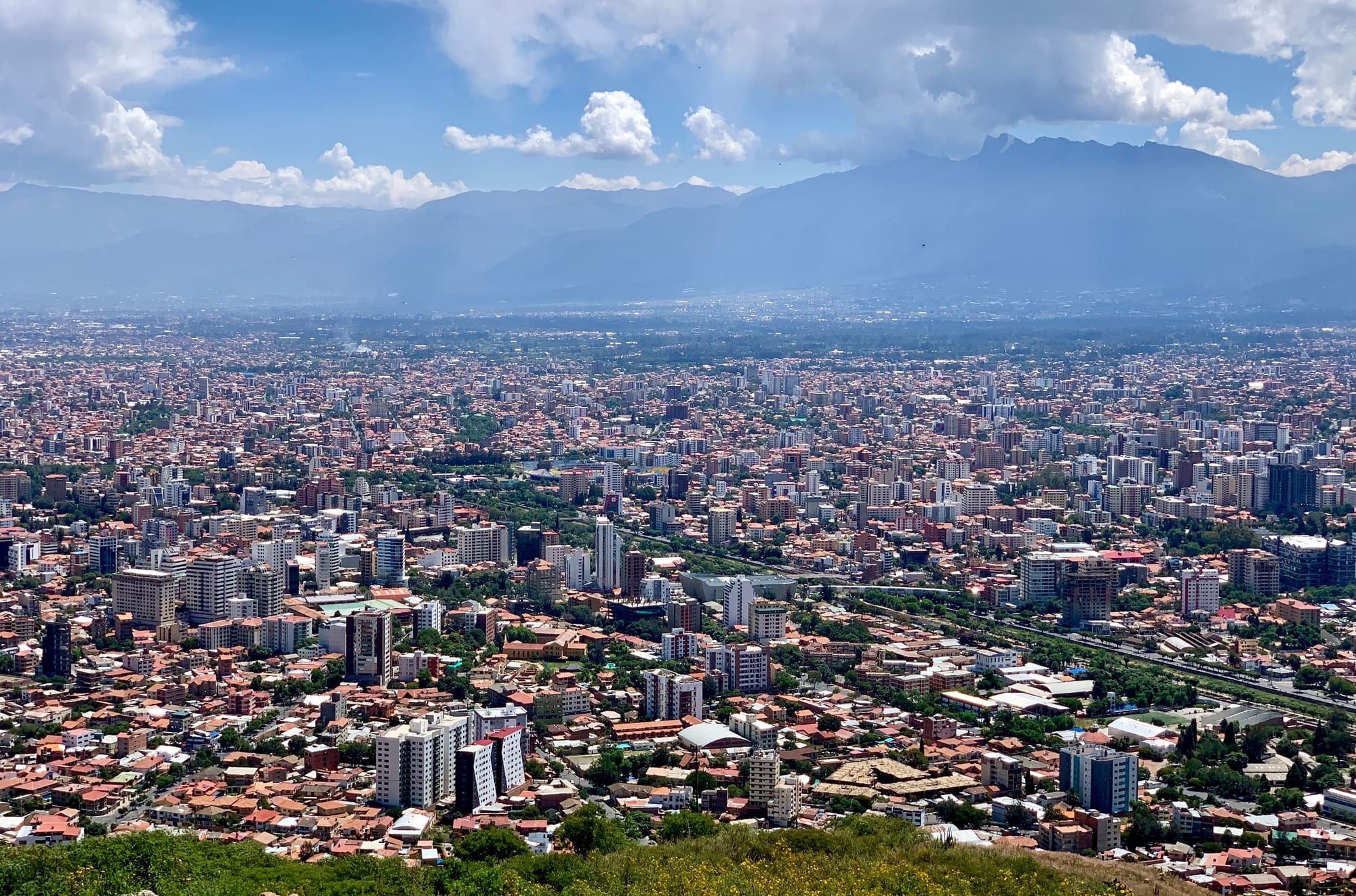
Dense blocks of flats and red-roofed houses filling a wide valley, with the long ridge of the Tunari range under clouds behind

Sucre, Cochabamba, Tarija & the Valleys, Bolivia

Cochabamba

The north of Cochabamba and the Tunari range, seen from San Pedro hill. (MollySVH / Wikimedia Commons · CC BY 2.0)

Bolivia's fourth-largest city, in a fertile valley at about 2,500 metres below the Tunari range, between La Paz and Santa Cruz. Founded by the Spanish in 1571 as a farming town that fed the silver mines, it is known as the city of eternal spring — a busy trading centre with a vast market, a giant hilltop Christ and, since 2017, a place in UNESCO's Creative Cities Network for gastronomy.

Neighbourhoods

  • Centre and Plaza 14 de Septiembre
    • First-time visitors
    • Historic district

    The main square, with the Cathedral of Saint Sebastian and flocks of pigeons, and the grid of busy streets around it. Banks, government offices, churches and the Santa Teresa convent museum are within a few blocks, and Plaza Colón, greener and next to the city hall, marks the northern edge.

    Open in Maps
  • El Prado and Calle España
    • Nightlife
    • Best for food
    • Shopping

    Avenida Ballivián, known as El Prado, is a tree-lined boulevard running north from Plaza Colón, with many of the city's better restaurants and hotels nearby. Calle España, a few blocks away, is the heart of the city's nightlife, with bars, cafés and small restaurants.

    Open in Maps
  • La Recoleta and the Zona Norte
    • Quiet and residential
    • Museums
    • Best for food

    The leafier, wealthier districts north of the centre, with modern flats, shopping streets and restaurants. The Palacio Portales and its gardens, built for the tin baron Simón Patiño, and the natural history museum next door are here.

    Open in Maps
  • La Cancha and the south
    • Markets
    • Local life

    The great market district between the centre and the south of the city, around the bus terminal. Beyond it the Zona Sur, near the airport, is poorer, with adobe houses and unpaved roads, and Alalay Lake lies in the south of the city.

    Open in Maps

Things to do

Famous landmarks

  • Cristo de la Concordialandmark

    A statue of Christ 33.44 metres tall, on a pedestal that brings it to 39.68 metres, standing on San Pedro hill east of the centre and reached by cable car or by about 2,000 steps.

    Open in Maps
  • Metropolitan Cathedral of Saint Sebastianlandmark

    The cathedral of the archdiocese of Cochabamba, on the main square.

    Open in Maps
  • Plaza 14 de Septiembrelandmark

    The main square and the city's centre, where independence is commemorated and a focus of the 2000 Water War protests.

    Open in Maps
  • El Pradoneighborhood

    The tree-lined Avenida Ballivián running north from Plaza Colón, a place for evening strolls, with the Plaza de las Banderas and occasional craft displays along the way.

    Open in Maps

Museums

  • Palacio Portalesmuseum

    The mansion built for Simón Patiño, the tin magnate who controlled more than half of Bolivia's output in the 1930s, now a cultural centre with gardens and a contemporary art centre.

    Open in Maps
  • Museo Arqueológicomuseum

    An archaeology museum with mummies, deformed skulls and pottery from the valley's long pre-Spanish history.

    Open in Maps
  • Museo Convento Santa Teresamuseum

    A colonial convent a couple of blocks south-west of Plaza Colón, now open as a museum.

    Open in Maps
  • Alcide d'Orbigny Natural History Museummuseum

    A natural history museum next door to the Palacio Portales in La Recoleta, named after the French naturalist who travelled through Bolivia.

    Open in Maps

Markets

  • La Canchamarket

    A huge commercial district of private and public markets between the centre and the south, selling everything from food and household goods to second-hand cars; Saturday is the busiest day.

    Open in Maps

Parks, lakes and sport

  • Alalay Lakepark

    A lake in the south of the city known for its waterfowl, with a cycle path, a jogging circuit and a bird observatory around its shore.

    Open in Maps
  • Estadio Félix Caprilesattraction

    The city's main stadium, with room for about 32,000 people, home ground of Club Jorge Wilstermann and Club Aurora and a venue for concerts and rallies.

    Open in Maps

Short trips from the city

  • Quillacolloattraction

    A town about 14 km west of the centre, part of the metropolitan area, and the home of the Virgin of Urkupiña, whose feast in August draws pilgrims from across the country.

    Open in Maps
  • Tunari National Parkpark

    The protected mountains north of the city, rising to the 5,023-metre summit of Tunari, the highest peak around the valley.

    Open in Maps
  • Inkallaqtaattraction

    A monumental Inca site in the hills east of the valley, with the Kallanka, a vast single-roofed hall.

    Open in Maps
  • Torotoro National Parkpark

    A park of canyons, caves and dinosaur trackways across the departmental line in northern Potosí, reached by a long road from the city.

    Open in Maps

Seasonal events

  • Fiesta de la Virgen de Urkupiñamid-August, around the 15th

    A major religious festival honouring the Virgin as patroness of national integration in Quillacollo, on the western edge of the metropolitan area, with a folk parade of about fifteen thousand costumed dancers on 14 August.

Eat and drink

Long-standing places and food districts in Cochabamba. Hours, ratings and directions come from your maps app, always current.

Cochabamba classics

  • Silpanchorestaurant

    A popular dish from the city: thin breaded beef over rice and potatoes, topped with fried eggs and chopped onion and tomato.

    Open in Maps
  • Chicharrónrestaurant

    Pork cooked slowly for five or six hours and served with mote, boiled hominy, and potatoes.

    Open in Maps
  • Chicharestaurant

    The traditional maize drink, in Bolivia usually fermented, sold in chicherías.

    Open in Maps

Food districts and markets

  • La Canchamarket

    The great market district, with food stalls among the produce sections serving set lunches, juices and local dishes.

    Open in Maps
  • Calle España and El Pradoneighborhood

    The streets where Cochabamba eats out and drinks in the evening, from local grills and pique macho to cafés and bars.

    Open in Maps

Experience Cochabamba

History

The Cochabamba valley has been farmed for thousands of years thanks to its fertile soils and mild climate. After the Inca conquest, Huayna Capac brought in some 14,000 colonists, called mitimas, to work the land as a maize estate for the empire. The Spanish founded the city in 1571 as the Villa de Oropesa, named after the title of Viceroy Francisco de Toledo, and the valley became the granary that fed the silver mines of Potosí. Its name comes from the Quechua qucha, lake, and pampa, plain, after the lakes that once covered the valley floor.

By the census of 1793 the city had about 22,000 people, and in 1846 it was the second-largest city in Bolivia after La Paz. Growth then stalled — in 1900 the population was still under 22,000 — before the city grew again in the 20th century. The tin baron Simón Patiño built his mansion, the Palacio Portales, in the north of the city.

Cochabamba became internationally known in 2000 for the Water War. After the city's water company was privatised to Aguas del Tunari, a consortium involving the American firm Bechtel, and rates rose sharply, the Coalition in Defence of Water and Life led months of protests, culminating in tens of thousands marching downtown and battling police; one civilian was killed. On 10 April 2000 the government agreed to reverse the privatisation. In 2022 the first lines of the Mi Tren light rail opened.

Culture & Customs

Cochabamba's identity rests on food, markets and festivals. Locals call it La Llajta, Quechua for "the town", and its people cochalas, and the city's food earned it a place in UNESCO's Creative Cities Network for gastronomy in 2017. Quechua is spoken widely in the markets and the surrounding valley towns.

The great festival is the Virgin of Urkupiña in Quillacollo, on the western edge of the metropolitan area, held around 15 August. Pilgrims come from all over Bolivia and South America, and the folk parade on 14 August brings about fifteen thousand costumed dancers.

The city has a strong student culture, centred on the public University of San Simón, founded in 1832, and private universities that draw students from the rest of Bolivia and abroad, which feeds the nightlife of Calle España and El Prado. The 2000 Water War remains a defining memory and inspired the 2010 film También la lluvia (Even the Rain). Football fans follow Club Jorge Wilstermann and Club Aurora at the Félix Capriles stadium.

Daily Life

About 665,000 people lived in the municipality of Cochabamba at the 2024 census, the fourth-largest in Bolivia. The city has grown well beyond its limits into a conurbation with Quillacollo, Sacaba, Tiquipaya, Colcapirhua, Vinto and Sipe Sipe, together forming the Kanata metropolitan region, the third-largest urban area in the country.

The local economy is the third-largest in Bolivia, built on trade, services, industry and the produce of the valleys and the tropical lowlands of the Chapare — bananas, citrus, pineapples and cocoa reach the city's markets. La Cancha is the commercial heart of daily life, while the central districts around Plaza Colón and Plaza 14 de Septiembre hold most of the formal businesses. The Zona Sur, near the airport, is much poorer, with adobe houses and unpaved streets.

Days are long and outdoor in the mild climate, with markets busy from early morning and lunch the main meal. Water is the city's chronic problem: rain is scarce, the Misicuni Dam north-west of the city was built to bring more, and supply remains a political issue. The national economic crisis, fuel shortages and road blockades on the Chapare highway to Santa Cruz weigh on a city that lives by moving goods.

Food

Cochabamba has been part of UNESCO's Creative Cities Network for gastronomy since 2017, and silpancho is one of its best-known dishes: pounded, breaded beef served over rice and potatoes, topped with fried eggs and chopped onion and tomato. Trancapecho puts the same ingredients inside a bread roll, and pique macho, a heap of beef, sausage, chips, onion and chilli, is also among the city's classic dishes. Chicharrón here is pork cooked slowly for five or six hours and served with mote, boiled hominy, and potatoes.

Llajwa, a sauce of tomato and locoto chilli, accompanies many dishes, and Cochabamba is one of the cities that claim the best salteñas, the pastries sold in the morning. The markets, above all La Cancha, sell fruit and vegetables from both the cool valleys and the tropical Chapare, along with set lunches, juices and snacks at their food stalls.

Chicha, in Bolivia most often a fermented maize beer, is the traditional drink, served in chicherías, the chicha taverns. Restaurants along El Prado and the streets of the Zona Norte range from traditional grills to international cooking, and Calle España is the place for an evening drink.

Planning tools

Budget

Cochabamba is cheap for eating out, with generous set lunches and market food, and hotels cost a little less than in La Paz. The extra costs are tours to Torotoro and taxis between districts. The national dollar shortage applies, so bring clean US dollar notes.

Daily Budget Midrange
USD 55–100 (hotel in the north, restaurant dinners, radio taxis, the Cristo cable car and museums)
Daily Budget Shoestring
USD 25–40 (hostel, set lunches and market meals, micros and trufis)

A Torotoro trip is the main extra cost; it is cheapest with a shared tour from the city.

Best Time to Visit

The mild climate makes Cochabamba pleasant all year. The dry season from May to October brings sunny days and cool nights and keeps the road to Torotoro open; the rains from November to March green the valley. Mid-August is the time of the Urkupiña festival in Quillacollo.

Suggested Number of Days

Two or three days are enough for the city and its markets. Allow four to six to add the surrounding valley towns, the mountains or a stay of two or three nights in Torotoro, and more if the roads are blocked.

First Visit
2–3 days
With Surroundings
4–6 days

Transportation

Micros, minibuses called trufis and shared taxis run along fixed routes across the metropolitan area, and the Mi Tren light rail, opened in 2022, links the city with San Simón University, El Castillo and Suticollo. A cable car climbs San Pedro hill to the Cristo. Taxis have no meter and drivers may overcharge visitors.

Use radio taxis, with a company name on the car, especially in the evening; agree the fare or ask the dispatcher for it before setting off.

Airport & Station Connections

Jorge Wilstermann International Airport, on the southern side of the city, is the main domestic hub of Boliviana de Aviación, with flights to La Paz, Santa Cruz and other Bolivian cities. The bus terminal is about ten blocks south of the centre, beside La Cancha: La Paz is at least eight hours away, and Santa Cruz, Sucre and Potosí at least ten.

Walkability

The centre is flat and laid out in a regular grid, so Plaza 14 de Septiembre, Plaza Colón, El Prado and La Cancha can all be reached on foot, and the climate makes walking pleasant. Distances to the northern districts and Alalay Lake are longer, and the city spreads far along the valley. Walking from the bus terminal, or anywhere after dark in the south, is best avoided.

Safety

Violent crime against tourists is relatively low, but manage the risks: fake-taxi and fake-police scams and express robberies occur in La Paz, Cochabamba, and on the Uyuni and Copacabana routes, and petty theft is common on overnight buses and in markets. In Cochabamba, pickpockets work La Cancha and the bus terminal, and the Cristo hill is best avoided after dark. The Chapare road to Santa Cruz is often cut by blockades, and protests paralysed much of the country in May and June 2026.

Use radio taxis, visit the Cristo by day, keep valuables hidden in markets and follow local news before crossing the Chapare. Check current official travel advice before travelling.

Climate

Known as the city of eternal spring: a semi-arid valley climate, never as humid as Santa Cruz nor as cold as La Paz. The long dry season runs from May to October and the rains from November to March; rain is sparse enough that water shortages are a recurring problem.

Summer
December to February: the wet season, warm, with most of the year's rain and highs that do not pass 35°C
Winter
June to August: dry and sunny, with mild days and cool nights that do not fall below -2°C

Local Customs

Cochabambinos, known familiarly as cochalas, are proud of their food and their festivals and take lunch seriously as the main meal of the day. Quechua is heard widely in the markets alongside Spanish. Religious festivals mix Catholic devotion with folk dance and music.

Ask before photographing market traders, dress modestly in churches, and round up or leave about 10 per cent in sit-down restaurants.

Common Payment Methods

The currency is the boliviano (Bs), which has floated against the US dollar since June 2026. Markets, trufis, taxis and most eateries take cash only; hotels, supermarkets and better restaurants in the north take cards, though payments sometimes fail. ATMs can run short, so carry clean US dollar notes and small boliviano notes.