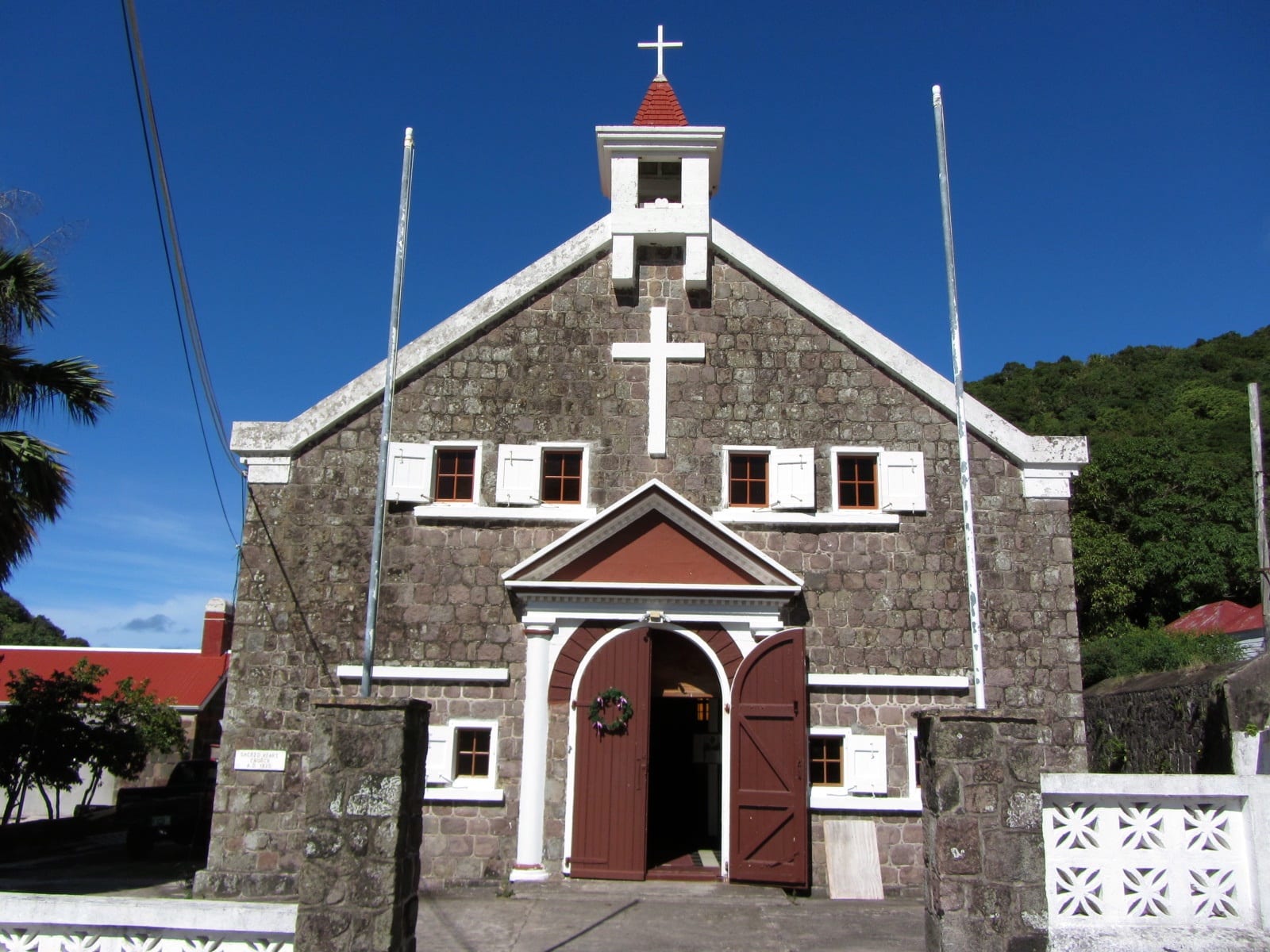
A stone church with white trim, a small belfry and open red doors under a deep blue sky, with green hills behind

Caribbean Netherlands

The Bottom

Sacred Heart Church in The Bottom, Saba. (Richie Diesterheft from Chicago, IL, USA / Wikimedia Commons · CC BY-SA 2.0)

The capital of Saba, a small village of houses with red roofs in a bowl-shaped valley below the island's volcanic peak. Settled by colonists from Zeeland in the 17th century and later by Irish, English and Scottish settlers and enslaved Africans, it is now the seat of government, with the island's hospital, churches and a medical school.

Neighbourhoods

  • The village centre
    • First-time visitors
    • Historic district
    • Quiet and residential

    The heart of the island's government, with the administration buildings, the hospital, three churches, the library, the sports field and a few shops, restaurants and bars along a handful of streets. It sits in a valley ringed by hills, and several hiking trails start from its edges.

    Open in Maps
  • Fort Bay
    • Diving
    • Ferry arrivals

    Saba's only port, about 1.6 kilometres by road below the village on the south coast. Ferries from Sint Maarten tie up here, dive boats use its pier, and most of the island's supplies come ashore here.

    Open in Maps
  • Windwardside
    • Restaurants and shops
    • Hiking

    Saba's second village, on the windward side of the island, with more of its places to eat and shop, a small museum in a sea captain's house and the main trail up Mount Scenery. Many visitors stay here and come down to The Bottom by taxi.

    Open in Maps

Things to do

In the village

  • Christ Churchlandmark

    The Anglican church, the island's oldest church on record, renovated in 1777 after hurricane damage.

    Open in Maps
  • Sacred Heart Churchlandmark

    The Catholic church, begun in 1877 and rebuilt in 1909 and again in 1934.

    Open in Maps
  • Major Osman Ralph Simmons Museummuseum

    A small museum of objects found on the island by the former island police officer after whom it is named.

    Open in Maps

Walks and the sea

  • The Laddertrail

    About 800 steps cut into the rock from the edge of the village down to Ladder Bay, once the landing place for the island's cargo; an abandoned customs house stands on the cliff above the bay.

    Open in Maps
  • Saba National Marine Parkpark

    The protected waters around the whole island, created in 1987, where dives include pinnacles of volcanic rock rising from the deep to within about 26 metres of the surface.

    Open in Maps
  • Fort Baytransit hub

    The island's only port, used by cargo boats, dive boats and ferries.

    Open in Maps

Short trips on the island

  • Mount Scenerytrail

    The dormant volcano that forms Saba, at 870 metres the highest point in the Kingdom of the Netherlands; a national park since 2019, with a trail up through several climate zones to cloud forest at the summit.

    Open in Maps
  • Windwardsideneighborhood

    The island's second village, with the Harry Luke Johnson Museum in a 19th-century sea captain's house and shops selling Saba lace and Saba Spice.

    Open in Maps

Seasonal events

  • Saba Carnivallate July

    A week-long summer festival with live music, food, dancing, games and parades, centred on Carnival Village in The Bottom; the Grand Parade takes place in The Bottom.

  • Saba Dayearly December

    The island's own day, when offices, schools and businesses close for performances, cookouts, fishing contests and a concert at the sports field.

Eat and drink

Long-standing places and food districts in The Bottom. Hours, ratings and directions come from your maps app, always current.

The Bottom classics

  • Bottom Bean Cafecafe

    A small café in the village.

    Open in Maps
  • Saba Spicemarket

    The island's sweet rum flavoured with local spices, made by Saban women and sold as a souvenir; a nip of it may end a meal.

    Open in Maps

Places to eat

  • Restaurants in The Bottomneighborhood

    A few restaurants and bars in the village, including one of the island's two Chinese restaurants.

    Open in Maps
  • Lollipop'srestaurant

    A bar just outside the village on the road towards Windwardside.

    Open in Maps

Experience The Bottom

History

Saba's first European settlers were colonists from Zeeland, who arrived around 1640. When a landslide destroyed their first settlement, they moved to a valley enclosed by mountains and called it De Botte — old Dutch for "the bowl". "The Bottom" is the English corruption of that name. Irish, English and Scottish settlers followed, with enslaved Africans, and English became the language of the island's villages.

By the 1860s The Bottom was one of seven districts on Saba, each with its own elected head, and in 1865 it had 616 inhabitants. Most men farmed or fished, and many built ships, one of the island's 19th-century industries, while women worked at home and made hats and Saba lace, a drawn-thread needlework. Building began on the Catholic Sacred Heart Church in 1877. A navigation school opened in 1909 and ran until 1922, and the Queen Wilhelmina Library opened in 1923.

Emigration in the early and middle 20th century almost halved the village, which had only 341 inhabitants by 1972. The island's single road, The Road, designed by the self-taught engineer Joseph "Lambee" Hassell and built by hand, began at Fort Bay and climbed to The Bottom, and the airport later opened at Flat Point on the far side of the island. The first supermarket opened in 1964, a small silk-screen printing works was built in 1972 to provide new jobs, and a medical school opened in 1992. When the Netherlands Antilles were dissolved in 2010, Saba became a special municipality of the Netherlands, with The Bottom as its seat of government.

Culture & Customs

The Bottom is English-speaking, and Saban English, the island's own variety, is heard in every shop and on The Road; the first dictionary of it was published in 2016. Dutch is official and taught in school, but English is the language of instruction. Families have deep roots, and a few surnames — Hassell, Johnson and Every above all — are shared by a large part of the island.

Church life matters. The village has three: the Anglican Christ Church, the oldest on the island on record; the Catholic Sacred Heart Church, begun in 1877; and the Wesleyan Holiness Church, begun in 1919. Catholics are now the largest denomination on Saba. Saba lace, known on the island as "Spanish work", is still made and sold, and Saba Spice, a sweet rum flavoured with local spices, is the island's best-known drink.

The village is the centre of the island's big celebrations. Saba Carnival, usually in late July, fills Carnival Village with a week of live music, food, dancing and parades, and the Grand Parade passes through The Bottom. On Saba Day in early December, offices, schools and businesses close, and islanders mark their culture with performances, cookouts, fishing contests and a concert at the sports field.

Daily Life

The village had 462 inhabitants at the last census, in 2001, and the whole island had about 2,160 people at the start of 2025, making Saba the smallest territory by permanent population in the Americas. The Bottom holds the island government offices, the hospital, a nursing home, the library, the sports field and a medical school.

Tourism now contributes more to the island's economy than any other sector, much of it from divers and hikers, alongside government jobs and the medical school. Supplies arrive by boat at Fort Bay, and imported goods are expensive. Life is organised around the sea, the trails, the church and the flight and ferry timetable, and in a village this size most people know each other.

Most families trace their ancestry to early Dutch, English and Scottish settlers and enslaved Africans. Saba elects its own island council, and its people are Dutch nationals; moving to the Netherlands for study, healthcare and work is common.

Food

Saba eats Caribbean-English home cooking. Goat water, a spiced goat stew, is the classic dish, alongside johnnycakes, saltfish, pea soup and pumpkin soup, fresh fish and lobster, with pigeon peas and rice on the side. The Saba Bank, a large submarine atoll a few kilometres south-west of the island, is a prime fishing ground, particularly for lobster.

Almost everything else is imported, and grocery stores in The Bottom and Windwardside are where many visitors buy food for their own meals. The village has a handful of restaurants and bars, including one of the island's two Chinese restaurants, and much of the island's eating out happens up the road in Windwardside.

The drink to know is Saba Spice, a sweet rum enhanced with local spices and still made by Saban women; a nip of it may end a meal, and bottles are a common souvenir. Rum, regional beers and fresh juices are the usual drinks in the bars.

Planning tools

Budget

Saba has only a handful of small hotels and guesthouses, and few ways to spend money beyond diving, taxis and meals. The main cost is getting there: a short, pricey flight or ferry from Sint Maarten. Groceries are imported and expensive, but self-catering from the village shops is still cheaper than eating out.

Daily Budget Midrange
USD 160–330 (small hotel or dive lodge, restaurant meals, taxis, guided dives)
Daily Budget Shoestring
USD 70–120 (guesthouse room, grocery-store meals, taxis or lifts between villages)

Book the limited flights or ferries from Sint Maarten well ahead, and leave spare days in case weather cancels a crossing.

Best Time to Visit

January to May is the driest period on the island and falls outside the hurricane season. Late July is carnival week, when the village is at its liveliest. The hurricane season runs from June to November.

Suggested Number of Days

The village itself can be seen in an hour or two, but most visitors come to dive or hike and stay several days on the island. Divers and serious walkers often stay a week; bad weather can also add a day at either end.

First Visit
3–4 days
With Surroundings
5–7 days

Transportation

One road, known as The Road, links Fort Bay, The Bottom, the other villages and the airport. It is narrow, steep and lined with stone walls. Taxis are the usual way between villages, with regulated fares, and a car can be hired in The Bottom. Hitchhiking between villages is common.

Watch how islanders drive The Road before deciding to hire a car; taxi drivers can be called to any village.

Airport & Station Connections

Juancho E. Yrausquin Airport, on the Flat Point peninsula, has the shortest commercial runway in the world at 400 metres. Winair flies small aircraft from Sint Maarten several times a day, weather permitting. Ferries from Sint Maarten arrive at Fort Bay, about 1.6 kilometres by road below the village.

Walkability

The village itself is small and walkable, though steep. Walking along The Road to the other villages is unpleasant, with fast traffic and no room at the edges, so a taxi or a lift is the better choice. The hiking trails that start from the village are the pleasant way to cover ground on foot.

Safety

All three islands have low crime and a strong community feel; petty theft from cars and unattended dive gear on Bonaire is the main issue. On Saba the real hazards are the steep, slippery trails, the narrow road, the sea, and the hurricane season. Medical facilities are basic, and serious cases may need transfer off the island.

Take a guide or a good map for the trails, carry water, wear proper shoes on wet steps, and carry insurance that covers diving and evacuation. Check current official travel advice before travelling.

Climate

Tropical and warm, tempered by the trade winds, with rainfall that varies with altitude and exposure to the wind. The hurricane season runs from June to November, and January to May is the driest period.

Summer
warm and humid, with daytime temperatures of 21–29°C across the island, in the hurricane season
Winter
daytime temperatures of 21–29°C and nights of 18–24°C across the island, in the drier season

Local Customs

English is the everyday language, spoken in a local variety known as Saban English, and Dutch is also official. Many islanders share a few surnames, and in a community of about 2,000 people almost everyone knows everyone. Christianity is central to life, with Catholic, Anglican and Wesleyan churches in the village.

Dress modestly in the village and in churches, and ask before photographing people.

Common Payment Methods

The currency is the US dollar. Cards are accepted in the main places on the island, but cash is useful for small shops, taxis and bars.