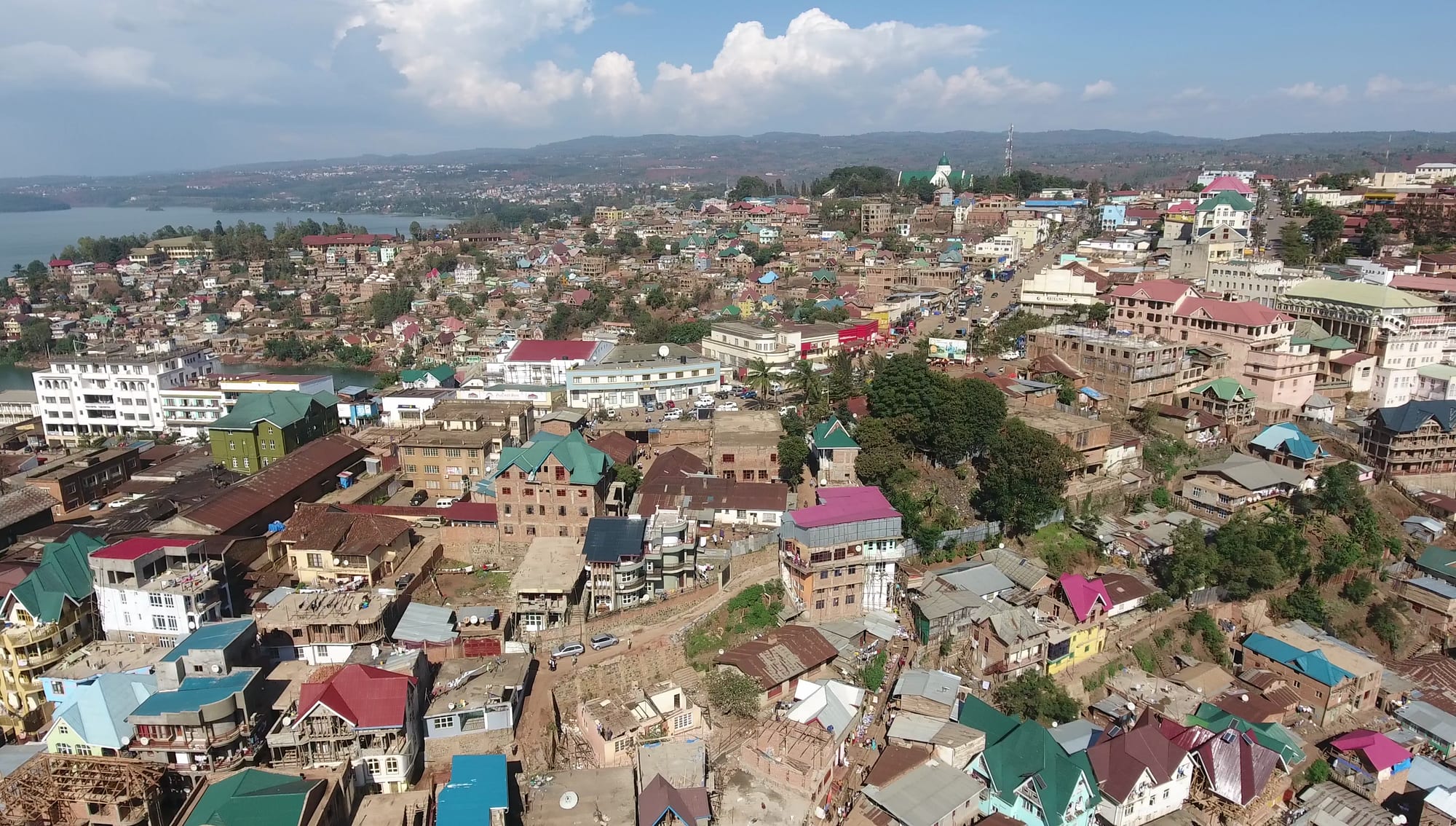
Dense hillside city of red, green and blue metal roofs falling towards a lake with wooded hills beyond

Goma, Bukavu & the Kivus, Democratic Republic of the Congo

Bukavu

The centre of Bukavu on its hills above the southern end of Lake Kivu. (EMMANRMS / Wikimedia Commons · CC BY-SA 4.0)

The capital of South Kivu, built across five hilly peninsulas at the southern tip of Lake Kivu where the Ruzizi river leaves the lake, with Rwanda immediately across the water. Established in 1901 and named Costermansville for part of the colonial period, it keeps streets of lakeside villas below crowded hillsides, and was taken by the M23 in February 2025. This page is written to explain the city, not to encourage travel.

Neighbourhoods

  • Ibanda
    • First-time visitors
    • Offices and banks
    • Lake views

    The central commune, spread over the peninsulas that reach into the lake. It holds the provincial offices, banks, the cathedral, the main avenues of shops and the surviving Belgian-era villas along the shore, and most hotels are here.

    Open in Maps
  • Kadutu
    • Markets
    • Local life

    The crowded commune in the valley behind the centre, built up the slopes with small brick and timber houses. It contains the city's largest market and much of its everyday trade, and its steep lanes turn to red mud in the rains.

    Open in Maps
  • Bagira
    • Local life
    • Quiet and residential

    The hillside commune to the west, laid out in part as planned housing in the colonial period and since grown far beyond it. It is residential and workaday, further from the lake and closer to the road towards Kahuzi-Biega.

    Open in Maps
  • Panzi
    • Local life

    A southern quarter on the way out of town towards the Ruzizi plain, known nationally for its hospital, which has treated survivors of sexual violence from across the east. It is residential, busy and growing.

    Open in Maps
  • Nguba and the lakeshore
    • Quiet and residential
    • Lake views

    The lakeside road of large houses, gardens and compounds on one of the peninsulas, used by organisations, businesses and the better hotels, with jetties for boats to Goma and Idjwi.

    Open in Maps

Things to do

The lake and the city

  • Lake Kivuattraction

    The deep rift lake that the city is built around, its bays and peninsulas giving Bukavu its shape, with pirogues and passenger boats working the water.

    Open in Maps
  • Ruziziattraction

    The river that drains Lake Kivu southwards to Lake Tanganyika, leaving the lake at Bukavu and forming the border with Rwanda as it goes.

    Open in Maps
  • Rusiziattraction

    The Rwandan district across the border, whose town of Rusizi — long known as Cyangugu — faces Bukavu at the crossing over the Ruzizi.

    Open in Maps
  • Kavumu Airporttransit hub

    The airport serving Bukavu, on the lake road north of the city, whose operating status follows the security situation.

    Open in Maps

Landmarks and institutions

  • Panzi Hospitallandmark

    The hospital founded in 1999 by the gynaecologist Denis Mukwege, who was awarded the Nobel Peace Prize in 2018; it specialises in treating survivors of conflict-related sexual violence.

    Open in Maps
  • Our Lady of Peace Cathedrallandmark

    The Catholic cathedral of Bukavu, known in French as the Cathédrale Notre-Dame de la Paix, seat of the archdiocese and one of the city's landmark buildings.

    Open in Maps

Short trips from the city

  • Kahuzi-Biega National Parkpark

    Established in 1970 west of the city and declared a UNESCO World Heritage Site in 1980, on the List of World Heritage in Danger since 1997, it is named after two extinct volcanoes and is the main refuge of the eastern lowland gorilla, also called Grauer's gorilla.

    Open in Maps
  • Mount Kahuzilandmark

    The extinct volcano rising above the montane forest west of Bukavu, at 3,317 metres the highest peak of the Mitumba Range along the lake.

    Open in Maps
  • Idjwiattraction

    The large inhabited island in the middle of Lake Kivu, part of South Kivu, with hills of bananas and coffee and a reputation for calm.

    Open in Maps

Eat and drink

Long-standing places and food districts in Bukavu. Hours, ratings and directions come from your maps app, always current.

Bukavu classics

  • Sambaza and lake tilapiarestaurant

    Small sardine-like sambaza from Lake Kivu, fried whole and eaten by the handful, and grilled or stewed tilapia are the dishes most associated with the lakeside city.

    Open in Maps
  • Brochettes and fried plantainrestaurant

    Charcoal-grilled skewers of goat or beef with fried potatoes or plantain, the usual evening meal in the bars along the central avenues.

    Open in Maps

Markets and food streets

  • Kadutu marketmarket

    The city's largest market, filling the valley behind the centre with beans, potatoes, cassava leaves, bananas, dried fish and household goods from the surrounding hills.

    Open in Maps
  • Avenue Patrice Lumumbaneighborhood

    The main street through Ibanda, lined with shops, bakeries, small restaurants and bars, and the place where the city eats out in the evening.

    Open in Maps
  • Nguba lakeside terracescafe

    Hotel terraces and cafés on the lakeshore peninsulas serve Kivu arabica coffee, grilled fish and bottled beer above the water.

    Open in Maps

Experience Bukavu

History

Bukavu was established in 1901 by the Congo Free State, which became the Belgian Congo in 1908, on the peninsulas at the southern end of Lake Kivu, and in 1927 was renamed Costermansville after Paul Costermans, a vice governor-general. Europeans were drawn to the altitude and the climate, and the town became a comfortable colonial centre, with villas in a distinctive Art Deco-influenced style along the lake, a cathedral, hotels and gardens, serving the coffee, tea and quinine estates of the Kivu highlands. The name was changed back to Bukavu in 1953.

After independence the town was caught up in the country's early crises, and under Mobutu it declined along with the rest of the state, though it remained the provincial capital of Kivu and then of South Kivu. The great rupture came in 1994, when the genocide in Rwanda sent hundreds of thousands of refugees into camps around the city and the lake; in 1996 the camps were broken up by a Rwandan-backed rebellion that captured Bukavu on its march west, and the Second Congo War followed from 1998.

The decades since have brought repeated fighting. Rebel forces briefly seized the city in 2004, and the surrounding province has never been free of armed groups. In February 2025, shortly after the fall of Goma, M23 fighters took Bukavu. Through all of it the city has kept growing, absorbing people displaced from the hills, so that the compact colonial town is now the crowded centre of a far larger city.

Culture & Customs

Bukavu is a Shi city in a Shi region: Mashi is the language of the hills around Lake Kivu's southern shore, spoken alongside the Congolese Swahili of the street and the French of offices and universities. The Lega, Bembe, Fuliru, Havu and Banyamulenge communities of South Kivu are all represented in the city, and its markets and churches are among the places where those worlds meet.

The Catholic Church has been central here since the colonial period — the archdiocese, its cathedral and its schools and hospitals are among the city's oldest institutions — and Protestant and Pentecostal churches have grown strongly. Civil society is unusually dense for a Congolese provincial capital: human rights organisations, women's associations and research and medical institutions have documented the conflict and supported its survivors, work most visible in the reputation of the Panzi hospital and its founder.

It is also a student city, with several universities and institutes, and the young population supports musicians, rappers, choirs and painters who perform in church halls, bars and cultural centres. Football is a shared passion, and the lakeside terraces are where the city socialises in the evening. Bukavu's own image of itself is bound up with its hills and its lake views, and with a sense of being cut off from Kinshasa and closer, in practice, to the countries across the border.

Daily Life

Bukavu has grown from a colonial town of a few thousand to a city with an estimated urban population of about 1,133,000 in 2021, most of that growth driven by families moving in from the countryside for safety or work. The three communes — Ibanda on the peninsulas, Kadutu in the valley and Bagira on the western hills — are built up steep slopes, which makes landslides a recurring danger after heavy rain and places great pressure on water and drainage.

The economy is trade, administration, education and aid. Produce from the hills comes into the markets daily, minerals from South Kivu's artisanal sites pass through the city's traders, and the border with Rwanda carries a constant flow of small commerce, much of it carried on foot. Universities, hospitals, churches and international organisations provide most formal employment, and a large informal economy of stalls, workshops and motorbike taxis carries the rest.

Daily life is shaped by the terrain and by scarcity: long uphill walks, crowded minibuses, irregular electricity and water, and queues at the border in the early morning. Since the events of early 2025 the city's banks, flights and administration have been affected and humanitarian needs have grown, and for many households displacement, high prices and interrupted schooling are the everyday reality.

Food

The food of Bukavu is highland food. Ugali, a stiff dough of maize or cassava flour, is the base of most meals, eaten with beans cooked slowly with onion and palm oil, or with sombe, the pounded cassava leaves stewed with groundnut or small dried fish that appear on tables almost daily. Potatoes, sweet potatoes and matoke, steamed cooking banana, come down from the hills of Kabare and Walungu.

The lake gives the city its specialities. Sambaza, the small sardine-like fish of Lake Kivu, are fried whole and crisp and eaten by the handful, and tilapia is grilled over charcoal or simmered in tomato and onion. Roadside braziers turn out goat and beef brochettes with fried plantain or chips, roasted maize is sold on the street, and everything can be lifted with pili-pili, the hot chilli paste.

South Kivu grows well-regarded arabica coffee on the slopes above the lake, washed at cooperatives around the shore and on Idjwi, though most of it is exported. Banana beer brewed in the surrounding villages is drunk at ceremonies and in rural bars, bottled lager is the city drink, and strong sweet tea, sometimes with milk and ginger, is taken through the day.

Planning tools

Budget

Bukavu is costly for visitors: hotel rooms are priced in US dollars for aid workers and business travellers, vehicles and drivers are expensive, and imported goods arrive through Rwanda. Market food, motorbike taxis and local restaurants are cheap in comparison, and prices rise whenever the roads or the border are disrupted.

Daily Budget Midrange
USD 200–500+ (city hotel or park package, driver, meals), before permits and flights
Daily Budget Shoestring
USD 60–110 (simple guesthouse, market food, motorbike taxis) — very limited in practice

Clean, recent US dollar notes are needed for hotels and vehicles, and worn or older bills are refused.

Best Time to Visit

The drier spells of June to August and around January to February give the best conditions on the hill roads and the forest trails west of the city. As elsewhere in the Kivus, security rather than season determines whether a visit is possible, and Kahuzi-Biega sets its own access rules.

Suggested Number of Days

The city is compact and a day or two covers it. Longer stays have been built around the forest west of town and the lake, which need extra time for slow roads, boat schedules and weather.

First Visit
1–2 days
With Surroundings
3–4 days

Transportation

Movement within Bukavu is by shared minibus, taxi and motorbike, along steep, winding and often congested roads that link the peninsulas and the valleys. Boats cross Lake Kivu to Idjwi and Goma from the lakeside jetties, the road north follows the shore towards Kavumu, and the road south runs down to Uvira and the Ruzizi plain.

Road travel beyond the city needs up-to-date security guidance from organisations working in South Kivu, and hill roads become difficult after heavy rain.

Airport & Station Connections

Kavumu Airport lies about 25 kilometres north of the city on the lake road and has handled domestic flights, its operating status depending on the security situation. Most visitors have historically arrived overland from Rwanda, crossing the Ruzizi bridges from Rusizi, formerly Cyangugu, after flying into Kigali, or by boat along Lake Kivu from Goma.

Walkability

The centre of Ibanda can be walked, though the city is built on steep hills and almost every route involves a climb. Pavements are broken or absent, traffic is heavy on the main avenues, and the distances between the communes are long, so motorbike taxis do most of the work. Walking after dark is not usual.

Safety

Bukavu lies in an active conflict zone. The city was taken by M23 forces in February 2025, weeks after Goma, and armed groups, militias and the Congolese army operate across South Kivu. Civilians face violence, kidnapping and displacement, and the province has a long record of sexual violence in the conflict. Street crime, unrest and disease outbreaks are further risks, and most governments advise against all travel to South Kivu.

Globeway covers the DR Congo so it can be understood, not to encourage travel there now. Border crossings, flights and park access can close without notice. Check current official travel advice before travelling.

Climate

At around 1,500 metres above sea level, Bukavu is temperate rather than hot, with mild days, cool nights and a great deal of rain: the hills above the lake are among the wetter parts of the country, and mist and cloud are common.

Summer
mild and wet, roughly 15–26°C, with long rains around March to May and September to December
Winter
drier and slightly cooler from June to August, with cloudy mornings and nights near 14°C

Local Customs

Congolese Swahili is the language of daily life, with French in offices, churches and schools and Mashi widely spoken by the Shi people of the surrounding hills. Greetings are formal and unhurried, dress is modest, and churches shape the week. Photography is sensitive: soldiers, police, the border and official buildings must never be photographed, and people should be asked first.

Tipping is not expected but small amounts are welcome; alcohol is freely sold; and cameras pointed at uniforms or checkpoints cause serious trouble.

Common Payment Methods

The Congolese franc is the official currency, while the US dollar is used for hotels, vehicles and larger payments, with prices often quoted in dollars. Notes must be clean, unmarked and recent. Card acceptance is limited to a few hotels, cash machines are scarce and unreliable, and mobile money is widely used.