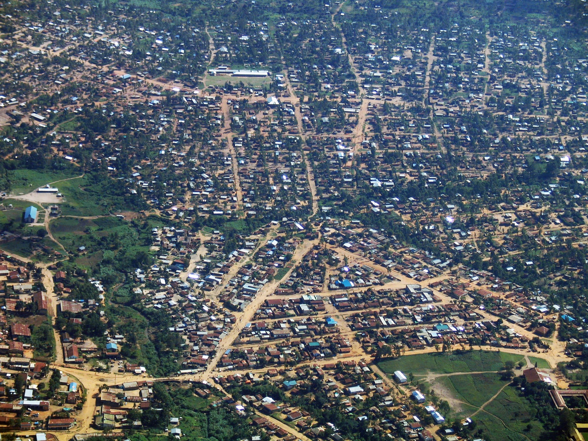
An aerial view of a large low-rise town of metal roofs and red earth streets spreading across green plateau country

Kisangani & the North, Democratic Republic of the Congo

Bunia

Bunia from the air, looking north across the plateau town that is the capital of Ituri province. (HokieRNB / Wikimedia Commons · Public domain)

The capital of Ituri province in the north-east of the DR Congo, on a plateau of grass and farmland west of Lake Albert and above the Ituri rainforest. A trading and administrative town grown large on gold, displacement and the presence of the United Nations mission. This page is written to explain the city, not to encourage travel.

Neighbourhoods

  • The town centre
    • First-time visitors
    • Markets
    • Local life

    The commercial and administrative core, with the provincial offices, banks, the main market, churches and the busiest stretches of road. Gold buyers, traders and transport agents keep it crowded through the day, and most of the town's lodging is within a short distance.

    Open in Maps
  • Nyakasanza
    • Local life
    • Markets

    A large residential quarter on the northern side of town, densely built with single-storey houses along unpaved streets, its own small markets and churches. It is one of the areas that grew fastest as families arrived from the countryside.

    Open in Maps
  • Mudzipela and the eastern quarters
    • Quiet and residential

    Residential ground on the eastern side of Bunia towards the road to the lake, mixing houses, gardens and small plots. The plateau air is cooler here than in the lowland towns, and the quarters thin into farmland quickly.

    Open in Maps
  • The airport quarter
    • Transport
    • Local life

    The area around the airport and the United Nations base on the edge of town, busy with aid organisations, transport yards and the businesses that serve them. It is where most arrivals and departures happen.

    Open in Maps

Things to do

In the town

  • Bunia central marketmarket

    The town's main market, long important for cross-border trade with Uganda, trading beans, maize, bananas, vegetables and fish from Lake Albert alongside manufactured goods.

    Open in Maps

Transport and arrival

  • Bunia Airporttransit hub

    The airport on the edge of town, the practical way in and out of Ituri; it closed briefly in May 2026 during the Ebola epidemic, and commercial flights were suspended again in June 2026.

    Open in Maps

Short trips from the town

  • Lake Albertattraction

    The Rift Valley lake on the Ugandan border below the plateau, whose Congolese shore supports fishing settlements such as Kasenyi and Tchomia.

    Open in Maps
  • Mongbwaluattraction

    A gold-mining town north of Bunia at the heart of the Kilo-Moto belt, worked industrially since the colonial period and by thousands of artisanal diggers today.

    Open in Maps

Eat and drink

Long-standing places and food districts in Bunia. Hours, ratings and directions come from your maps app, always current.

Markets and food streets

  • The central marketmarket

    Beans, maize, sweet potatoes, bananas, groundnuts and vegetables from the plateau farms, with fresh and smoked fish carried up from Lake Albert.

    Open in Maps
  • Grill stalls of the centreneighborhood

    Small kitchens and braziers along the main streets serving grilled goat, chicken and fish with ugali, beans, rice or fried plantain, and sweet milky tea in the morning.

    Open in Maps

Experience Bunia

History

Bunia grew where the Ituri forest gives way to the open grassland of a plateau above Lake Albert, country long shared by Hema herders, Lendu farmers, Alur, Bira and other communities. The Belgian administration established a post here early in the twentieth century, and the discovery of gold in the Kilo-Moto belt from around 1903 turned the district into a mining region worked commercially from 1905. Bunia became its administrative and supply centre, with an airstrip, mission schools and a trade route east to Uganda.

Independence left the gold economy in decline and much of the extraction in the hands of artisanal diggers. From 1999 competition over land, cattle and mining ground between Hema and Lendu communities, deepened by the armies and factions involved in the Second Congo War, turned Ituri into one of the most violent parts of the country. Bunia changed hands repeatedly, and in 2003 heavy fighting in the town prompted a European Union force to deploy there before a larger United Nations presence took over. In 2012 the Ituri militia leader Thomas Lubanga became the first person convicted by the International Criminal Court.

Violence revived from 2017 with the CODECO militia and, from the south-east, the Allied Democratic Forces, and army operations against the armed groups have continued. Through all of it Bunia has grown rapidly, its population swollen by families displaced from the countryside, and it has become the base for the United Nations mission and the aid organisations working in the province.

Culture & Customs

Ituri is one of the most ethnically complex parts of the DR Congo, and Bunia is where its communities meet. Hema, Lendu, Alur, Bira, Nyali and others live in the town, along with traders from Uganda and from across the country, and the Mbuti hunter-gatherers of the forest to the west come to the markets. Swahili is the shared language, a legacy of the eastern trade routes, with French in official use.

The province's cultural inheritance is partly pastoral and partly of the forest. Cattle-keeping shapes Hema life and gives the plateau its dairy tradition, while farming communities mark harvests and funerals with drumming and dance; Mbuti polyphonic singing, performed in the Ituri forest, has drawn musicologists for decades. Churches — Catholic, Protestant and revival — are the strongest civic institutions, running schools and clinics and organising much of social life.

Communal identity is a delicate subject here, because the conflict has been fought largely along those lines, and residents tend to treat questions about origins with caution. What the town shares instead is a practical, mobile culture built around trade, remittances and the constant movement of people: Congolese rumba and East African music mixed in the bars, football watched wherever there is a screen and a generator, and a way of conducting business quickly because circumstances can change.

Daily Life

Bunia has grown quickly in recent decades, its population swollen by displacement from the surrounding territories. Camps and informal settlements of displaced families sit on the edges of the town, and many households shelter relatives from villages they can no longer farm.

Gold underpins the economy. Artisanal miners dig around Mongbwalu and other sites in the province, and the metal is traded through Bunia towards Uganda; the industrial mines of the Kilo-Moto belt have a longer, more troubled history. Alongside that the plateau produces beans, maize, cassava, bananas and vegetables, Hema herders keep cattle, and fish comes up from Lake Albert. Cross-border trade, provincial administration, the aid sector and the United Nations mission account for most salaried employment.

The rhythm of the day is early and busy: markets from dawn, motorbike taxis shuttling through the centre, business concluded well before dark because movement at night is avoided. Electricity is intermittent and generators are widespread, water supply is uneven, and health services are stretched by displacement and by epidemic response. Insecurity on the roads, the cost of food, and the length of the crisis are the constant subjects of conversation.

Food

Bunia eats like the East African highlands rather than the Congo basin. The daily staple is ugali, a stiff dough of maize or cassava flour, eaten with beans, stewed greens or vegetables and, when a household can afford it, goat, chicken or beef. Sweet potatoes, cassava, bananas and plantain from the plateau farms fill out the plate, and groundnuts appear in sauces and as a snack.

Fish is carried up the escarpment from Lake Albert, fresh or smoked and salted, and grilled or stewed with tomato, onion and chilli. Cattle-keeping by Hema families makes milk and beef more common here than in most of the country, and roadside grills of goat and beef skewers are a feature of the town's streets in the evening. Cassava leaves stewed with palm oil, known as pondu or sombe, arrive from the forest side of the province, and rice is eaten in town.

Tea taken with sugar and often with milk is the everyday drink, a habit shared with Uganda across the border, alongside strong coffee. Banana and sorghum beers are brewed at home in the surrounding countryside, palm wine comes from the forest areas, and bottled lager, much of it trucked in from Uganda, is drunk in the bars of the centre.

Planning tools

Budget

Bunia's hotels and guesthouses exist for aid workers, traders and officials and charge in US dollars for what are modest rooms. Market food is cheap, motorbike taxis cost little, and the real expenses are flights, vehicle hire and security arrangements. Cash machines are scarce and unreliable.

Daily Budget Midrange
USD 150–300 (hotel in Kisangani, driver, meals), before flights and any park fees
Daily Budget Shoestring
USD 40–80 (basic guesthouse room, market food, motorbike taxis)

Bring clean, undamaged US dollar notes for the whole stay; Ugandan shillings circulate near the border but cards are of no use.

Best Time to Visit

The plateau has a drier spell from about December to February, when the unpaved roads harden and travel is least difficult, and a long wet season from March to November with heavy afternoon storms. Security, not season, determines whether any movement in Ituri is possible at all.

Suggested Number of Days

The town itself is small and can be taken in quickly. Any additional time depends entirely on whether movement outside Bunia is possible, and on flights, which are infrequent and change at short notice.

First Visit
1–2 days
With Surroundings
2–3 days

Transportation

Motorbike taxis dominate, with shared pickups and minibuses on the main roads and a few cars for hire. Streets in the centre are partly paved and the outer quarters are on red earth that turns to mud in the rains. The roads to Lake Albert, to the Ugandan border and west through the forest are rough and their use depends on the security situation.

Organise all movement through an organisation with staff on the ground, travel only in daylight, and expect frequent checkpoints.

Airport & Station Connections

Bunia Airport, at the edge of town, is the normal way in, with flights to Kinshasa, Goma and other eastern cities, although commercial flights were suspended in June 2026 during the Ebola epidemic. Overland routes run east to the Ugandan border and west through the Ituri forest towards Kisangani, but the forest road in particular has been exposed to armed attacks.

Walkability

The centre is compact, flat enough and walkable by day, with the market, offices and main streets close together. Pavements are intermittent, motorbike traffic is heavy, and the outer quarters are spread out. The plateau's altitude keeps the heat manageable compared with the lowlands.

Safety

Ituri is part of the eastern conflict zone. Armed groups including the CODECO militia and the Allied Democratic Forces have killed large numbers of civilians in the province and displaced hundreds of thousands, camps for displaced families sit close to the town, and the army mounts repeated operations against armed groups in the province. An Ebola epidemic first reported in Ituri in May 2026 has killed thousands of people in the east. Bunia itself is protected by the army and the United Nations mission but the roads around it are dangerous.

Globeway covers the DR Congo so it can be understood, not to encourage travel there now. Most governments advise against all travel to Ituri; anyone who goes does so with an organisation that has its own security and medical arrangements. Check current official travel advice before travelling.

Climate

The plateau sits at about 1,275 metres, which makes Bunia noticeably cooler and less humid than the forest lowlands to the west. Rain falls through most of the year, heaviest from March to November, with a drier spell from about December to February. Nights can feel cool.

Summer
warm days and mild nights, generally about 16–29°C, with frequent afternoon storms
Winter
drier from December to February, about 16–30°C, with dusty air and cooler nights

Local Customs

Swahili is the common language of the street, with French in offices and schools and Lendu, Hema, Alur and other languages spoken at home. Churches are central to community life, dress is modest, and greetings are unhurried, with elders addressed first.

Community identity is politically sensitive in Ituri, so avoid asking people which group they belong to and avoid discussing the conflict in public. Never photograph soldiers, checkpoints, the airport, camps or displaced families.

Common Payment Methods

Congolese francs are used for markets and transport and US dollars for rooms, vehicles and larger sums; Ugandan shillings are accepted by some traders because of the border trade. Cards are not usable and cash machines are unreliable, so all money has to be carried in clean notes.