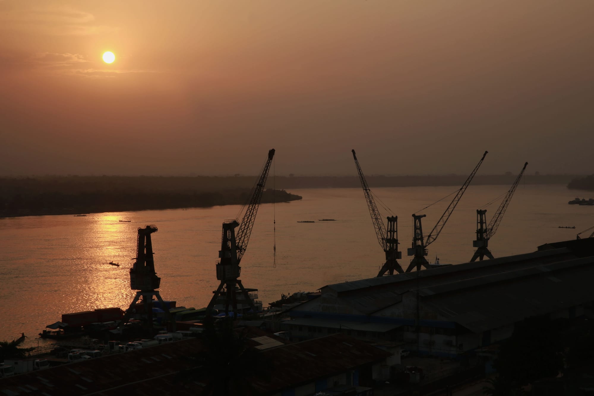
Silhouetted dockside cranes and warehouse roofs above a wide river turned gold by a low sun

Kisangani & the North, Democratic Republic of the Congo

Kisangani

The port of Kisangani on the Congo River at sunset, at the head of the river's long navigable stretch to Kinshasa. (MONUSCO / Abel Kavanagh / Wikimedia Commons · CC BY-SA 2.0)

The capital of Tshopo province, a river city just north of the equator at the point where the Boyoma Falls end and the Congo becomes navigable all the way to Kinshasa. Founded by Henry Morton Stanley in 1883 and renamed Kisangani in 1966, it has a port, a university and a long history of war. This page is written to explain the city, not to encourage travel.

Neighbourhoods

  • Makiso
    • First-time visitors
    • Historic district
    • Close to the river

    The old colonial centre on the right bank, with the provincial offices, the cathedral, banks, the main hotels and tree-lined boulevards running down to the waterfront. Much of the city's surviving early twentieth-century architecture stands here, some of it worn and some restored.

    Open in Maps
  • The port and the waterfront
    • River life
    • Markets

    The working riverside below the centre, where barges are loaded for the weeks-long journey downstream to Kinshasa and pirogues come and go. Warehouses, fuel tanks and traders' yards line the bank, and business follows the arrival and departure of convoys.

    Open in Maps
  • Kabondo and Mangobo
    • Local life
    • Markets

    Densely settled residential communes inland from the centre, where most of the city's population lives in single-storey houses along unpaved streets. Small markets, churches, bars and workshops give each quarter its own centre of gravity.

    Open in Maps
  • Tshopo and the northern quarters
    • Quiet and residential
    • Riverside walks

    The area beyond the Tshopo river towards the falls of the same name, quieter and greener than the inner communes, with gardens, small farms and the bridge that carries the road north out of the city.

    Open in Maps
  • Wagenia
    • Fishing traps
    • River life

    The riverside community at the last of the Boyoma cataracts, upstream of the centre, where Wagenya families set conical basket traps from timber scaffolds in the rapids. It is a working fishing place rather than a visitor site.

    Open in Maps

Things to do

The river and the falls

  • Boyoma Fallslandmark

    A chain of seven cataracts running more than 100 km down the Lualaba to the city, ending at the rapids where Wagenya fishermen set basket traps from wooden tripods; by annual flow they form the largest waterfall in the world.

    Open in Maps
  • Tshopo Riverattraction

    The tributary that joins the Congo at the city, with falls and a small hydroelectric station a few kilometres from the centre and a bridge carrying the northern road.

    Open in Maps
  • The river porttransit hub

    The quays where barge convoys are assembled for the long journey downstream to Kinshasa, and where goods for the whole province are landed.

    Open in Maps

City landmarks

  • University of Kisanganiattraction

    The public university, founded in 1963 as the Free University of the Congo and given its present name in 1981, with eight faculties from science and law to arts and humanities.

    Open in Maps
  • Kisangani Cathedrallandmark

    The Catholic cathedral in the old centre, a brick church of the colonial era and the seat of the archdiocese.

    Open in Maps
  • Bangoka International Airporttransit hub

    The city's airport, about 12 km east of town, handling flights to Kinshasa and to the eastern cities.

    Open in Maps

Markets

  • The central marketmarket

    The main market of the city centre, selling smoked and fresh river fish, cassava, plantain, forest produce and imported goods brought upriver by barge.

    Open in Maps

Short trips from the city

  • Yangambiattraction

    A former colonial agricultural research station on the Congo downstream of the city, at the centre of a biosphere reserve declared under UNESCO's Man and the Biosphere Programme in 1976, with a herbarium holding some 150,000 dried plant specimens.

    Open in Maps

Eat and drink

Long-standing places and food districts in Kisangani. Hours, ratings and directions come from your maps app, always current.

Markets and food streets

  • The central market food stallsmarket

    Smoked and grilled river fish, chikwangue loaves, pondu, plantain and forest mushrooms sold from stalls and cooked at the market's edges.

    Open in Maps
  • Grill kitchens of Makisoneighborhood

    Open-fronted kitchens and braziers in the central commune grilling fish, goat and chicken to order, served with fufu, rice or fried plantain.

    Open in Maps
  • Riverside barsneighborhood

    Simple bars along the waterfront and the boulevards where bottled lager and palm wine are drunk with grilled fish and Congolese rumba playing into the night.

    Open in Maps

Experience Kisangani

History

The falls decided everything. Where the Lualaba drops through seven cataracts, the river ceases to be navigable from downstream, and the Wagenya and neighbouring communities had long fished and traded at the break. By the nineteenth century the Swahili-Arab networks of Tippu Tip had reached the area, dealing in ivory and slaves, and in 1883 Henry Morton Stanley established a station at the falls that grew into Stanleyville. Tippu Tip was made governor of the Stanley Falls district by the Congo Free State in 1887, before war broke out between the state and the Arab traders in the 1890s.

Under Belgian rule the town became the commercial capital of the upper Congo, the place where goods transferred between the river barges and the railway that bypassed the falls, and where rubber, ivory, cotton and later gold from the north-east were handled. It acquired boulevards, a cathedral, a port and an administrative quarter.

Politics made it turbulent after independence. Stanleyville was Patrice Lumumba's stronghold, and after his murder his supporters set up a rival government there. In 1964 Simba rebels seized the city and held American and European residents hostage until Operation Dragon Rouge, mounted by Belgian paratroopers alongside Congolese troops and foreign mercenaries, freed them. The city was renamed Kisangani in May 1966 under Mobutu Sese Seko's authenticité policy. During the Second Congo War the Rwandan and Ugandan armies, once allies, fought each other in the city in June 2000, in the deadliest of three such confrontations there, destroying about a quarter of it. Kisangani has been rebuilding, slowly, ever since.

Culture & Customs

Kisangani is where the river culture of the Congo basin meets the Swahili world of the east. Lingala and Swahili are both street languages here, used according to company and neighbourhood, with French for administration and education; the mixture is one of the things residents point to when explaining what makes the city distinct from Kinshasa or Goma.

The Wagenya fishing families at the falls are the best-known local tradition, their trap-building technique passed down through generations and inseparable from the rapids themselves. In the wider region the Mangbetu and Azande of the north are known for carved harps and pottery, and Mbuti communities of the Ituri forest for polyphonic singing; their work and produce reach Kisangani's markets and workshops.

Church life is strong across Catholic, Protestant and revival congregations, and choirs are a serious business, rehearsing through the week for Sunday. Evening belongs to music: Congolese rumba and its descendants play from bars along the boulevards, and live bands appear at weekends. The university gives the city a student population and a tradition of debate, theatre and forest science. Manners are formal by regional standards — greetings before business, respect for elders — and residents carry a wry pride in a city that has been fought over repeatedly and is still standing.

Daily Life

Kisangani had an estimated 1.6 million people in 2016, which makes it the country's fifth-most populous urban area, though it feels less like a metropolis than a very large town spread thinly along the river. Most residents live in the communes inland from the centre in single-storey houses with cassava plots and mango trees behind them.

The economy runs on the river, the forest and the state. The port handles timber, fuel, cement and manufactured goods moving between Kinshasa and the interior; sawmills and palm-oil operations work in the surrounding province; traders bring gold and produce from the north-east; and the provincial administration, the university and international organisations provide most salaried employment. Informal trade and small workshops occupy nearly everyone else.

The day begins before six, when markets fill and motorbike taxis crowd the boulevards, and slows in the heat of the afternoon before a second burst in the evening. Electricity from the Tshopo station is intermittent and generators are common; water supply is uneven; the roads out of the city are poor enough to make the region feel like an island. Isolation, the cost of imported goods, employment and the security of the roads east and north are the standing concerns of city life.

Food

The Congo and the surrounding forest supply most of what Kisangani eats. River fish — catfish, tilapia and many local species — is grilled over wood, stewed, or wrapped in leaves with onion, tomato and chilli and steamed as liboke; large quantities are smoked on racks for keeping and for sale downriver. Fresh fish from the traps at the falls is a point of local pride.

Cassava is the everyday starch, pounded into fufu or fermented and wrapped as chikwangue, and its leaves are stewed with palm oil and smoked fish as pondu, also called saka-saka. Plantain, makemba in Lingala, is boiled, fried or roasted at the roadside; rice and maize round out the plate. Groundnut sauces thicken stews, palm oil colours them orange-red, and pili-pili chilli is added by the spoonful or served as a paste. Because Swahili-speaking eastern traditions reach the city, maize dough called ugali and dishes of beans and greens appear alongside the river food.

Forest produce is sold in the markets in season: wild mushrooms, honey and edible caterpillars, the last a delicacy fried with onion. Palm wine is tapped in the villages around the city and drunk fresh; bottled lager, brewed in the country, is the standard drink of the bars; and strong sweet coffee and tea are taken early in the morning.

Planning tools

Budget

Kisangani's few hotels serve traders, aid workers and United Nations staff and are priced in US dollars well above what the city otherwise costs. Market food and motorbike taxis are cheap; flights, vehicle hire and fuel are not. Cash machines exist but cannot be relied on.

Daily Budget Midrange
USD 150–300 (hotel in Kisangani, driver, meals), before flights and any park fees
Daily Budget Shoestring
USD 50–90 (simple guesthouse room, market food, motorbike taxis)

Bring clean, undamaged US dollar notes for the whole stay and change small amounts into Congolese francs for markets and transport.

Best Time to Visit

Sitting on the equator, Kisangani is wet through the year, with the heaviest rain around March to May and again from September to November. The shorter, drier breaks around January and in mid-year make the roads and the unpaved streets easier, and river levels affect what boats can do.

Suggested Number of Days

Two or three days cover the city and the falls at an unhurried pace. Add more for anything on the river or downstream, where travel is slow and departures depend on boats, weather and fuel rather than a timetable.

First Visit
2–3 days
With Surroundings
4–5 days

Transportation

Motorbike taxis are the backbone of movement, with shared minibuses and pickups on the main routes and a few taxis. Roads in the centre are paved but broken in places, and the outer communes are on dirt. Pirogues cross the river and serve riverside settlements, and the Tshopo bridge carries traffic north.

Agree fares before riding, avoid travelling out of the city after dark, and expect checkpoints where documents are inspected.

Airport & Station Connections

Bangoka International Airport, about 12 km east of the centre, is the usual way in, with flights to Kinshasa and to eastern cities; schedules change often. The alternative is the Congo itself, by barge from Kinshasa, a journey of several weeks with no fixed departure. Roads to the east and north are long, rough and frequently cut.

Walkability

The central grid of Makiso is flat and easy to walk, with the cathedral, the offices and the waterfront close together and shade from the old avenue trees. Distances grow quickly beyond it: the falls, the airport and the outer communes are all a ride away, and heat and humidity shorten any walk by the middle of the day.

Safety

Kisangani is calmer than the provinces east of it, but it is a poor city with street crime, occasional unrest and very limited emergency medical care. The roads leading east towards Ituri and north through the forest are exposed to armed groups and banditry, and the wider region has been affected by conflict and by the Ebola epidemic that began in Ituri province in May 2026 and has since spread to several provinces, Tshopo among them.

Globeway covers the DR Congo so it can be understood, not to encourage travel there now. Arrange anything beyond the city through an organisation with staff on the ground, avoid the overland roads east and north, and take malaria precautions seriously. Check current official travel advice before travelling.

Climate

Equatorial and consistent: hot, humid and wet for most of the year, with two rainfall peaks and no true dry season. Rain usually arrives as heavy afternoon and evening storms, and temperatures barely change from month to month.

Summer
hot and humid, generally about 21–31°C, with frequent heavy storms
Winter
much the same, about 21–30°C, with a slightly drier spell around December to February

Local Customs

Kisangani is a meeting point of languages: Lingala from the river and Swahili from the east are both widely spoken, with French in offices and schools. Churches are central to the week, dress is modest and neat, and greetings are unhurried, with elders addressed first.

Ask before photographing people, and never photograph the port, the airport, bridges, soldiers or government buildings. Tipping is not customary; small payments for help or for a boatman's time are normal.

Common Payment Methods

The Congolese franc is used for everyday purchases and US dollars for hotels, transport and larger sums, often by preference. Card payment is rare and cash machines are few and unreliable, so money for the visit has to be carried in cash, in clean, unmarked notes.