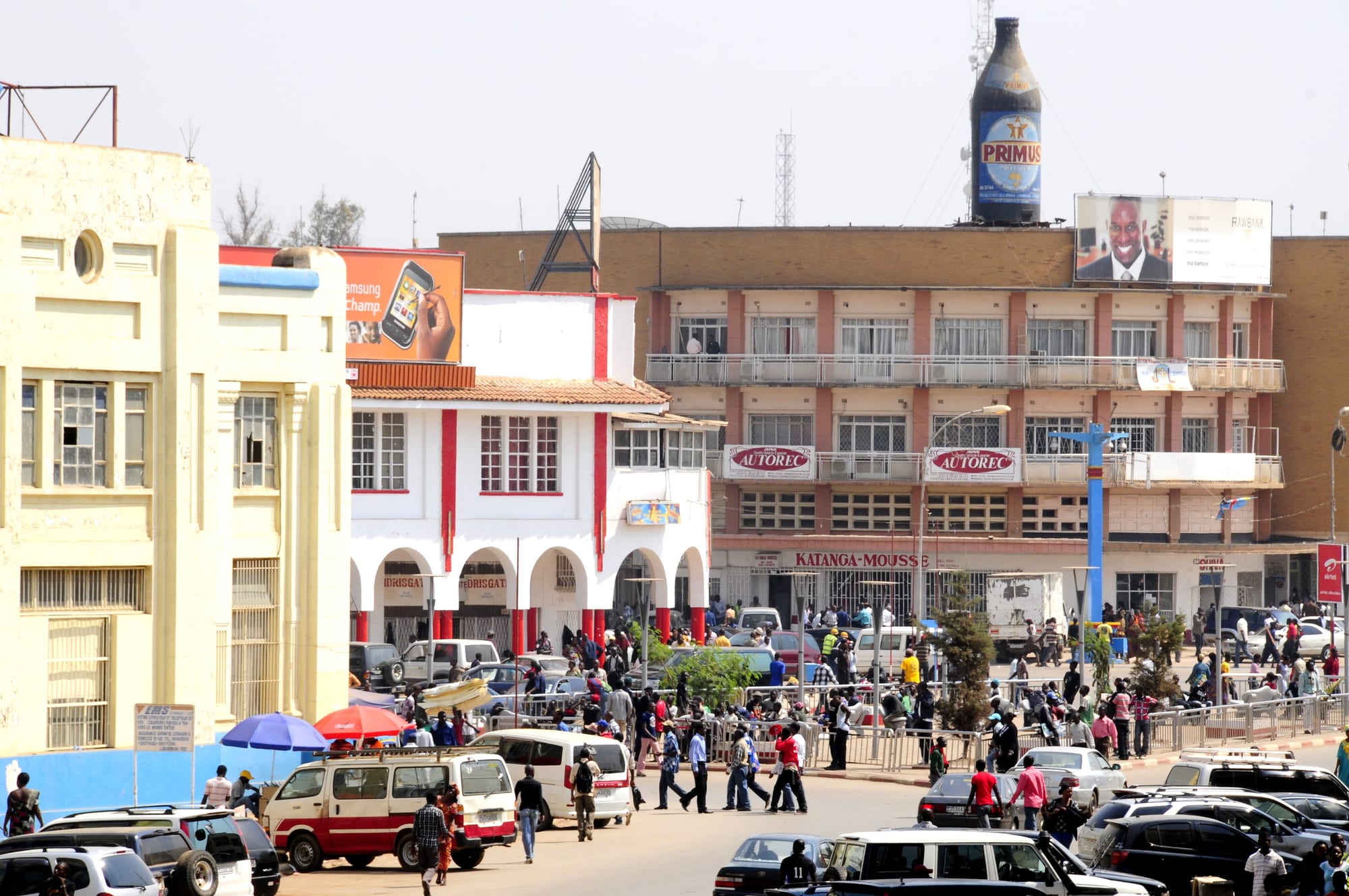
A busy city square with low colonial-era arcaded buildings, minibuses, parked cars and crowds of people crossing the road

Lubumbashi & Katanga, Democratic Republic of the Congo

Lubumbashi

A square in central Lubumbashi, lined with arcaded buildings from the Élisabethville period. (T. Thielemans / Wikimedia Commons · CC BY 3.0)

The capital of Haut-Katanga and the largest city of the DR Congo's southern copper belt, founded in 1910 as Élisabethville beside a copper smelter on the railway from what is now Zambia. It keeps a grid of wide colonial-era avenues under the black slag heap of the Gécamines works, and lives from mining, trade and its own strong Katangese identity.

Neighbourhoods

  • Lubumbashi commune and the centre-ville
    • First-time visitors
    • Offices and banks
    • Historic district

    The colonial-era grid of wide avenues, arcaded shopfronts and jacaranda trees, with the post office, banks, the cathedral, ministries and most of the city's hotels. It is the commercial heart and the part that most clearly shows the Élisabethville plan.

    Open in Maps
  • Golf and the residential avenues
    • Quiet and residential
    • Green streets

    The low-density quarter of walled villas, gardens and embassies laid out for managers and officials, south-east of the centre. Mining companies, international organisations and wealthier households are concentrated here, and the streets are wide and shaded.

    Open in Maps
  • Kamalondo
    • Local life
    • Nightlife
    • Historic district

    One of the oldest African quarters of the city, laid out in the colonial period south of the centre. It has a dense grid of small houses, street bars and music, and a reputation as the place Lubumbashi goes out in the evening.

    Open in Maps
  • Katuba
    • Local life
    • Markets

    A large, crowded and politically vocal commune of small plots and busy market streets in the south-west, built up from the mining-era workers' quarters. It is residential and self-contained, with its own markets and churches.

    Open in Maps
  • Kenya and Ruashi
    • Local life

    Working-class communes east of the centre, close to the Ruashi mine and its open pits. Houses are small and plots tight, and daily life is bound up with mining work, both industrial and artisanal.

    Open in Maps
  • Annexe
    • Quiet and residential

    The vast outer commune ringing the built-up city, part suburb and part countryside, where Lubumbashi has expanded fastest. It mixes newer housing estates, small farms and plots along the roads out of town.

    Open in Maps

Things to do

Landmarks and museums

  • National Museum of Lubumbashimuseum

    The city's museum, founded in 1946, with core collections in archaeology and ethnography.

    Open in Maps
  • Sts. Peter and Paul Cathedrallandmark

    The brick Catholic cathedral of the Élisabethville period, seat of the archdiocese, standing on one of the wide central avenues among the city's best-known buildings.

    Open in Maps
  • University of Lubumbashilandmark

    The main university of the south-east, whose campus north-east of the centre grew out of the state university founded in the city in the 1950s.

    Open in Maps

Sport and green space

  • Stade TP Mazembeattraction

    The home ground of TP Mazembe, the Lubumbashi football club that has won the African Champions League several times and is the pride of Katanga.

    Open in Maps

Getting around and out

  • Lubumbashi International Airporttransit hub

    The city's airport, also known as Luano, about 10 kilometres north-east of the centre, with flights to Kinshasa and to neighbouring countries.

    Open in Maps

Short trips from the city

  • Kipushiattraction

    A border town built around a mine worked since the 1920s for copper, lead and zinc, on the frontier with Zambia.

    Open in Maps
  • Kasumbalesaattraction

    A major crossing point for cargo and people between the DR Congo and Zambia, where over 500 long-haul trucks are cleared each day in each direction and queues of ore and fuel trucks build up.

    Open in Maps
  • Likasiattraction

    A copper and cobalt town on the road towards Kolwezi, laid out in the colonial period as Jadotville and surrounded by mines and plants.

    Open in Maps

Eat and drink

Long-standing places and food districts in Lubumbashi. Hours, ratings and directions come from your maps app, always current.

Lubumbashi classics

  • Nshima with fish or meat saucerestaurant

    The Katangese staple is a stiff maize porridge, eaten with beans, greens, dried ndakala fish or a meat sauce, and served in small local eating houses across the city.

    Open in Maps
  • Grilled goat and chickenrestaurant

    Charcoal-grilled goat, chicken and beef with chips or fried plantain, sold at roadside braziers and in the open-air bars, especially in the evenings.

    Open in Maps

Markets and food streets

  • Central market streetsmarket

    The produce markets of the centre sell maize meal, beans, dried fish, greens and caterpillars in season, alongside imported goods trucked up from Zambia and South Africa.

    Open in Maps
  • Kamalondo bars and grillsneighborhood

    The old quarter's streets of terraces and small bars, where Tembo beer from the city's Simba brewery is drunk with brochettes and music plays late.

    Open in Maps
  • Avenue Lumumba restaurantsneighborhood

    The main central avenue and the streets around it hold most of the city's sit-down restaurants, bakeries and cafés, including Indian, Lebanese and Chinese kitchens serving the mining community.

    Open in Maps

Experience Lubumbashi

History

Lubumbashi was founded in 1910 as Élisabethville, named after the Belgian queen, when the Union Minière du Haut-Katanga built a copper smelter beside the small Lubumbashi river and the railway arrived from Rhodesia to the south. The site had no town before it; what grew was a company city, laid out on a grid with a European quarter separated by a neutral zone from the African quarters where workers recruited from across Katanga and beyond were housed. Copper, and later cobalt, paid for everything.

By the middle of the century it was the industrial capital of the Belgian Congo, with schools, a cathedral, a university and a smelter whose black slag heap rose over the skyline. Independence in 1960 made it the capital of Moïse Tshombe's secessionist State of Katanga, a breakaway backed by Belgian interests and mercenaries; Patrice Lumumba was flown here and killed in Katanga in January 1961, and United Nations forces fought in and around the city before the secession ended in 1963.

Under Mobutu the city was renamed Lubumbashi in 1966 and the province became Shaba. A university massacre in 1990 became one of the scandals of the late Mobutu years. The state mining company Gécamines, successor to the Union Minière, collapsed in the 1990s, and the city's recovery came instead from a wave of foreign mining investment from the 2000s, mostly Chinese and Western, which has made the surrounding Copperbelt central to the world's supply of cobalt and reshaped Lubumbashi as a business city.

Culture & Customs

Lubumbashi is the capital of a region with a pronounced sense of itself. Many Katangese see their province as the country's economic engine, an attitude that has produced both political assertiveness and an easy local pride. The city speaks a distinctive Katangese Swahili, laced with French and Luba words and markedly different from the Swahili of the east coast, and it looks south to Zambia and South Africa at least as much as north-west to Kinshasa.

Its best-known cultural export is a school of popular painting that grew up in the city, in which artists recorded colonial rule, forced labour, independence and the mining life in bright, narrative canvases that have since entered museum collections abroad. The Biennale of Lubumbashi is held across the city every two years, showing work by artists from the region, and the university has long been a centre of writing and research on Katanga's history.

Football is close to a civic religion. TP Mazembe, based in Lubumbashi, is among the most successful clubs in African football, and match days colour the whole city. Catholic and Protestant churches, mining company associations and family networks organise much of social life; Sunday is for church and then for visiting; and evenings belong to the terrace bars of Kamalondo and the neighbourhood grills, where Congolese rumba and Zambian and South African music play side by side.

Daily Life

Lubumbashi is the country's second-largest city, its urban area estimated at about 2,584,000 people in 2021, and it continues to spread into the Annexe commune and along the roads out of town. The contrasts are sharp: walled villas and company compounds in the Golf quarter, dense plots in Katuba, Kenya and Ruashi, and new estates on the edge where farmland is being built over.

Mining underpins everything. Industrial operations around the city and along the Copperbelt road produce copper and cobalt, and the country holds the world's greatest cobalt deposits; alongside them tens of thousands of artisanal miners dig by hand, often in dangerous conditions and sometimes including children, a practice that has drawn international scrutiny. Trucking, freight forwarding, banking, trade and the university provide most other formal work, and the city imports much of its manufactured food from Zambia and South Africa.

Days begin early, with minibuses heading for the mines and the markets before dawn and offices working through to the afternoon. Power cuts and water interruptions are routine, and generators are common. The everyday concerns people talk about are the cost of living, the dust and pollution from mining and smelting, disputes over land around the pits, and the gap between the wealth the region produces and the state of its schools, hospitals and roads.

Food

Lubumbashi eats like the southern plateau. The staple is nshima, a stiff maize porridge shaped by hand and dipped into a relish — beans stewed with onion and palm oil, pounded cassava leaves, pumpkin leaves, or a sauce of meat or fish. It is closer to the food of Zambia than to that of the Congo basin, and cassava and sweet potatoes fill out the plate.

Fish arrives dried and fresh: ndakala, the tiny dried fish sold by the cupful in every market, and fish from Lake Tanganyika, Lake Mweru and the Luapula and Lualaba rivers. Goat, beef and chicken are grilled over charcoal at street braziers and bar terraces with chips or fried plantain, and after the first rains caterpillars gathered in the miombo woodland are fried with onion and chilli and sold by the bowl. Mushrooms from the same woodland appear in season.

Lubumbashi brews its own beer: the Simba brewery in the city produces Tembo, the brand drunk on the terraces; home-brewed maize and sorghum beers are made in the villages around the city. Supermarkets stocked with South African and Zambian goods, along with Indian, Lebanese and Chinese restaurants serving the mining community, give the city a more cosmopolitan table than anywhere else in the country outside Kinshasa.

Planning tools

Budget

Lubumbashi has mining-city prices. Hotels are aimed at companies and contractors and charge international rates in US dollars, imported food and wine are expensive, and vehicles with drivers cost well above the regional average. Markets, local restaurants and shared taxis are far cheaper, and most residents live entirely in that economy.

Daily Budget Midrange
USD 150–300 (business hotel, driver, restaurant meals)
Daily Budget Shoestring
USD 50–90 (simple guesthouse, market food, shared taxis) — limited options

Carry clean US dollars as well as francs; cards are accepted in some hotels and supermarkets in the city but rarely beyond it.

Best Time to Visit

May to September, the dry season, when the skies are clear, the roads are passable and the nights are cool. October is hot and dusty before the rains break, and the wet months from November to April bring heavy afternoon storms and slow travel outside the city.

Suggested Number of Days

A day or two covers the centre and the museum comfortably. Longer stays are usually work-related or take in the Copperbelt road and the country around the city, where distances are long and journeys slow.

First Visit
1–2 days
With Surroundings
3–4 days

Transportation

The city is spread out and flat. Shared taxis and minibuses run along the main avenues and out to the communes, motorbike taxis fill the gaps, and most visitors use a hired car with a driver. A paved road links the city north-west to Likasi and Kolwezi and south to the Zambian border, both busy with mining trucks, and the old railway runs slowly and irregularly.

Travel the Copperbelt road by daylight, allow for long truck queues near the mines and the border, and agree taxi fares before setting off.

Airport & Station Connections

Lubumbashi International Airport, also known as Luano, lies about 10 kilometres north-east of the centre and handles domestic flights and services to neighbouring countries. Many arrivals come overland from Zambia through the Kasumbalesa crossing, around 75 kilometres south, and freight and some passengers still use the railway towards the south and north.

Walkability

The colonial grid at the centre is flat, shaded in places by jacarandas and easy enough to walk in daylight, and the museum, cathedral and main avenues lie within a few blocks of one another. Beyond that the city spreads for kilometres, pavements are broken and traffic is fast, so walking is not the usual way to cover distance, and taxis are used after dark.

Safety

Lubumbashi is outside the eastern war and is among the more settled large cities in the country, but ordinary crime is a real concern: street robbery, theft from vehicles and burglary, with more risk after dark and around markets and the bus stations. Road accidents are common, power cuts frequent, and demonstrations and tensions around the mines can close roads at short notice. The countryside north of the city has seen militia activity in the past.

Most governments advise caution throughout the DR Congo; the Copperbelt cities are the most practical part of the region, and the rural north and the parks need local guidance. Photographing mines, soldiers, police or official buildings causes serious trouble. Check current official travel advice before travelling.

Climate

The city stands at about 1,200 metres on the Katangese plateau, which makes it far milder than its latitude suggests. A long dry season runs from about May to September with warm days and cold nights, and the rains fall from October to April in heavy afternoon storms.

Summer
the rainy season, October to April: warm and humid, roughly 17–29°C, with thunderstorms
Winter
the dry season, May to September: sunny days near 25°C and cold nights that can fall towards 7°C

Local Customs

A Katangese form of Swahili mixed with French and Luba words is the language of the street, with French in offices and schools. Greetings are formal and unhurried, and handshakes are held. Dress in the city is neat, churches are full on Sundays, and football loyalties are taken seriously. Mines, military sites, police and government buildings must never be photographed, and people should be asked first.

Tipping is modest and not obligatory; alcohol is widely sold; and identity documents should be carried, as checks are routine.

Common Payment Methods

The Congolese franc is the official currency and is used for everyday purchases, while the US dollar is standard for hotels, rents, vehicles and larger bills, with prices often quoted in dollars. Notes must be clean and recent. Cards work in some city hotels and supermarkets, cash machines exist but are unreliable, and mobile money is widely used.