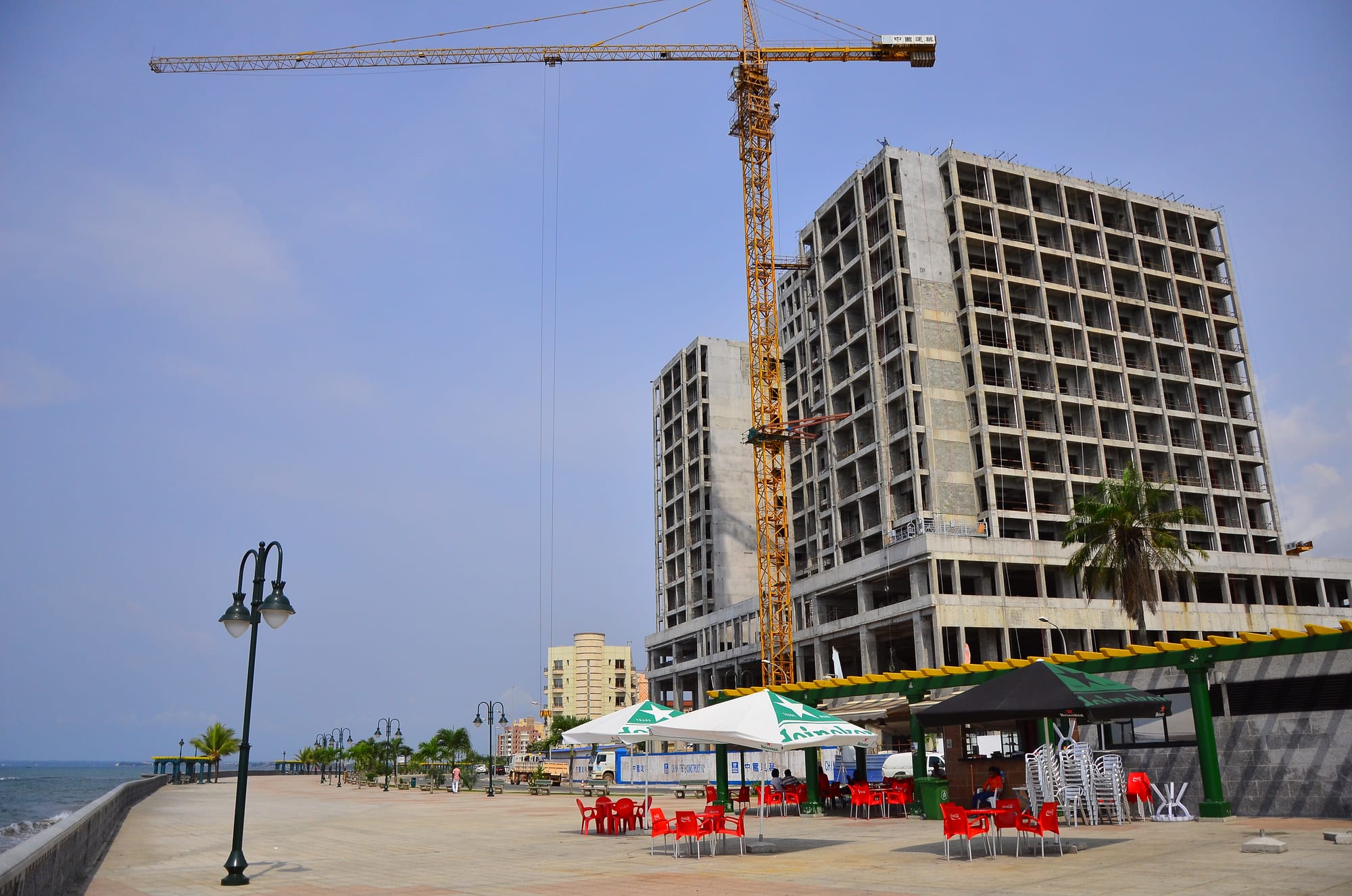
A wide tiled seafront promenade with iron lamp posts and palm trees, cafe umbrellas and red chairs, and a tall concrete building under construction

Equatorial Guinea

Bata

The seafront promenade at Bata, looking along the Atlantic shore past cafe terraces and new construction. (Ben Sutherland from Crystal Palace, London, UK / Wikimedia Commons · CC BY 2.0)

The largest city of Equatorial Guinea and the main centre of the mainland region of Río Muni, a port on the Atlantic with a long seafront promenade, busy markets and roads running inland to the rainforest. It grew as a timber and coffee port under Spanish rule and again during the oil years. This page is written to explain the city, not to encourage travel.

Neighbourhoods

  • The centre and the seafront
    • First-time visitors
    • Walks by the sea
    • Cafes

    The grid of streets between the port and the shore, with the cathedral, banks, airline offices and most hotels, opening onto the tiled promenade along the Atlantic. It is the part of the city that fills in the evening when the heat eases.

    Open in Maps
  • The market quarter
    • Markets
    • Local life

    The dense streets inland from the centre around the central market, where produce from the mainland forest and imported goods are traded, with workshops, stalls and street food along the main roads.

    Open in Maps
  • The inland districts
    • Quiet and residential
    • Local life

    The residential quarters spreading inland from the centre, low-built and often unplanned, many without reliable water or electricity, where most of the city's people live.

    Open in Maps
  • The port and airport road
    • Transport links

    The deep-water port and the road north to the airport, with warehouses, offices and newer compounds built during the oil boom.

    Open in Maps

Things to do

In the city

  • Paseo Marítimoattraction

    The long tiled promenade along the Atlantic shore, lined with lamp posts, palms and cafe terraces, and the centre of evening life in the city.

    Open in Maps
  • Torre de la Libertadlandmark

    The Freedom Tower, a monument on the promenade by the river mouth, inaugurated at the independence celebrations of October 2011, lit in changing colours at night and topped by a revolving restaurant.

    Open in Maps
  • Bata Cathedrallandmark

    The Catholic cathedral of St James and Our Lady of the Pillar, built in 1954 during the Spanish colonial period and one of the country's three cathedrals.

    Open in Maps
  • Gran Mercado Centralmarket

    The city's main market, one of the things Bata is best known for, where forest produce, fish, cloth and imported goods are traded.

    Open in Maps
  • Estadio de Bataattraction

    The largest stadium in the city, built by a Chinese contractor and completed in 2007, then enlarged to 35,000 seats to stage the opening of the 2012 Africa Cup of Nations.

    Open in Maps

Getting around

  • Bata Airporttransit hub

    The country's second airport, north of the city, with a long runway and flights to Malabo and other domestic airports.

    Open in Maps

Short trips from the city

  • Monte Alén National Parkpark

    The country's largest national park, about 2,000 square kilometres of rainforest inland from the coast, home to forest elephants, gorillas and chimpanzees.

    Open in Maps
  • Mbinineighborhood

    A small coastal town south-west of Bata at the mouth of the Benito River, known for its seafood and nearby beaches.

    Open in Maps
  • Ciudad de la Pazneighborhood

    The purpose-built city in the mainland forest east of Bata, given capital status by presidential decree in January 2026 and still under construction.

    Open in Maps

Seasonal events

  • Independence DayOctober

    The anniversary of independence from Spain in 1968, marked with official parades and public events.

  • Semana SantaMarch or April

    Holy Week services and processions, the most widely observed religious season in this strongly Catholic country.

  • Christmas and New YearDecember and January

    A long holiday season of church services and family gatherings.

Eat and drink

Long-standing places and food districts in Bata. Hours, ratings and directions come from your maps app, always current.

Bata classics

  • Grilled fish and plantainrestaurant

    Atlantic fish grilled over charcoal and served with fried plantain, cassava or rice is the standard meal of the coast.

    Open in Maps
  • Pepesuprestaurant

    The country's signature fish soup, hot with chilli and pepper, cooked in small local eating houses.

    Open in Maps

Markets and food streets

  • The central marketmarket

    Cassava, plantain, yam, groundnuts, forest produce and fish, traded from dawn, with cooked-food stalls around the edges.

    Open in Maps
  • Seafront cafes and terracesneighborhood

    The promenade is lined with open-air places serving grilled food, beer and soft drinks in the evening.

    Open in Maps
  • Spanish-style bakeriescafe

    Bread, pastries and coffee in the Spanish manner, a lasting legacy of the colonial period.

    Open in Maps

Experience Bata

History

Bata began as a small coastal settlement on the Río Muni shore, in Fang and coastal Ndowe country, and grew into the mainland's main port under Spanish administration. Spain took a serious interest in the mainland only from the 1880s, when coastal towns signed protectorate treaties, and fixed the borders of Río Muni by the Treaty of Paris with France in 1900 and extending control inland over the following decades. Bata became the administrative centre of that mainland province, exporting timber and coffee through its port, and much of its planned centre was laid out from the 1950s.

After independence in 1968 the country entered the years of Francisco Macías Nguema's rule, during which tens of thousands of people fled the country. After anti-Spanish riots in 1969 most of Bata's European population left, and the city went through severe economic stagnation in the 1970s and early 1980s.

Recovery came with the oil boom, which drove the city's development from the late 1980s and 1990s. Bata gained one of the deepest seaports in the region, expanded with Chinese loans, new highways running inland, a large stadium and the long seafront promenade, and its population grew quickly with migration from the interior. In March 2021 a series of explosions at a military base in the city killed more than 100 people. Bata is now the largest city in the country and the main city of the mainland, the nearest large town to the new inland capital at Ciudad de la Paz.

Culture & Customs

Bata is a Fang city above all: the Fang, the largest people of the mainland and also spread across Gabon and Cameroon, dominate its life and language, alongside coastal Ndowe communities, whose country Bata once was, and immigrants from elsewhere in Africa. Spanish is the common language of school, office and street sign, with Fang spoken at home and French and Portuguese present officially.

The Fang cultural inheritance includes the mvet, a harp-zither whose music is learned by initiates of the bebom-mvet society, and reliquary sculpture that inspired much of the European avant-garde art of the twentieth century. Drumming, dance and masquerade belong to weddings, funerals and community celebrations, and family obligation and respect for elders remain strong.

Catholicism is deeply rooted: Sunday mass, patron saints' days, Holy Week and Christmas are the fixed points of the public calendar, and church choirs are among the liveliest musical life in the city. Older beliefs persist alongside church practice. Public cultural expression is limited by tight restrictions on media and assembly, so most social life happens in the family, the church, the market and, in the evening, along the seafront, where football and music are the shared enthusiasms.

Daily Life

Bata had about 310,000 residents at the last census, making it the largest city in Equatorial Guinea and the centre of the mainland region where most of the country's people live. Growth has come from migration out of the forest interior, and most residents live in low-built districts spreading inland from the old centre rather than near the sea.

The economy rests on the port, on government administration, on construction work financed by oil revenue, and on trade — much of it informal, run through the market and on the street. Fishing and small-scale farming of cassava, plantain and cocoa supply the city from the surrounding country. Formal jobs are scarce relative to the number of young people, imported goods are costly, and power and water supply are uneven outside the centre. The economic downturns of recent years have slowed construction and made work harder to find.

The rhythm of the day follows the heat and the rain. Markets and building sites start at first light, the middle of the day is slow, and the late afternoon brings the city back out — taxis full, stalls lit, and the promenade crowded with families, footballers and food sellers until late.

Food

Bata eats the food of the mainland forest and the Atlantic coast. Cassava, plantain, yam, cocoyam and rice are the bases, cooked with sauces of groundnut, palm oil and pounded leaves. Bambucha, crushed cassava leaves boiled with palm-kernel juice and spices, is a national standard, and pepesup, a fiery fish soup, is the dish most identified with the country as a whole.

Fish dominates the coast: grilled whole over charcoal, smoked for keeping, or stewed with tomato, onion and chilli, and served with fried plantain or cassava sticks. Game and bushmeat from the interior also reach the market, along with snails, and the cooking is known for its strong flavours and heavy spice. Dishes taken from neighbours and the colonial power include the Cameroonian ndolé and the Spanish tortilla.

The Spanish inheritance is visible in bread and pastries and in coffee drunk in the Spanish style. Topé, the local palm wine, and malamba are the traditional drinks, alongside imported beer and Spanish wine in the restaurants of the centre.

Planning tools

Budget

Bata is expensive and geared to business rather than tourism. Hotels are priced for contractors and officials, most goods are imported, and getting anywhere beyond the city means a hired vehicle with a driver. Cash in CFA francs is needed for nearly everything.

Daily Budget Midrange
USD 200–400+ per day (hotel, hired car with driver, permits and meals)
Daily Budget Shoestring
USD 100–180 (a simple guesthouse, local eateries and shared taxis)

Arrange transport and any permits in advance, and change euros for CFA francs; card payment is rarely possible outside a few hotels.

Best Time to Visit

The drier spells, roughly December to February and again around June to August, are the most practical for the forest roads inland. The heaviest rain falls in April and May and again in October and November, when unpaved routes can become impassable.

Suggested Number of Days

The city is small enough to see in a day or two. Three to five days allow for the rainforest and the coast to the south, where roads are slow and arrangements take time. Rain and paperwork, more than distance, decide the pace.

First Visit
1–2 days
With Surroundings
3–5 days

Transportation

Taxis are the normal way to move around the city. Minibuses and shared cars leave for other mainland towns, and highways link Bata with Mongomo, Ciudad de la Paz and the southern coast.

Carry a passport and any permits at all times; police and military checkpoints are frequent on the mainland highways.

Airport & Station Connections

Bata Airport lies north of the city, with flights to Malabo and other domestic airports; its runway operates only in daylight. Ferries link Bata with Malabo and with Douala in Cameroon, on schedules that vary. Roads lead east to Mongomo on the Gabonese border and north towards Cameroon.

Walkability

The centre and the seafront are flat and walkable, and the promenade is the one long, pleasant walk in the city. Beyond the centre pavements are patchy and distances lengthen, so taxis are usual. Heat, humidity and sudden heavy rain shape how far anyone walks at any time of day.

Safety

Serious crime against visitors is rare, but the security presence is heavy, with checkpoints in and around the city, frequent document checks and strict limits on photography. Petty theft can occur in markets and crowded places, and road conditions and night driving on the highways are a practical risk.

Serious crime against visitors is uncommon, but Equatorial Guinea is a tightly controlled state with a heavy security presence, and the main risks are political and bureaucratic: arbitrary detention, harassment at checkpoints, and severe restrictions on photography and on any perceived criticism of the government. Check current official travel advice before travelling.

Climate

A tropical monsoon climate, hot and humid all year, with the mainland's average temperature about 27°C and little seasonal variation. Rain is the variable: two wetter periods, in April and May and in October and November, when monthly totals of around 300 mm are typical, separated by drier spells.

Summer
the middle of the year is comparatively drier but remains hot and humid, averaging about 27°C
Winter
December to February is hot and relatively dry, averaging about 27°C, the easier season for travel inland

Local Customs

Spanish is the language of public life and greetings are formal. Dress is neat and modest in the street, with beachwear kept to the shore. Catholic practice is strong, and Fang custom shapes family and community life on the mainland. Political discussion in public is avoided.

Do not photograph government buildings, the port, the airport, checkpoints or anyone in uniform, and ask before photographing people. Carry identification and permits at all times.

Common Payment Methods

The currency is the Central African CFA franc, pegged to the euro. Cash is used for almost everything; cards are accepted at only a few hotels, and ATMs are unreliable. Euros are the practical currency to bring and change on arrival.