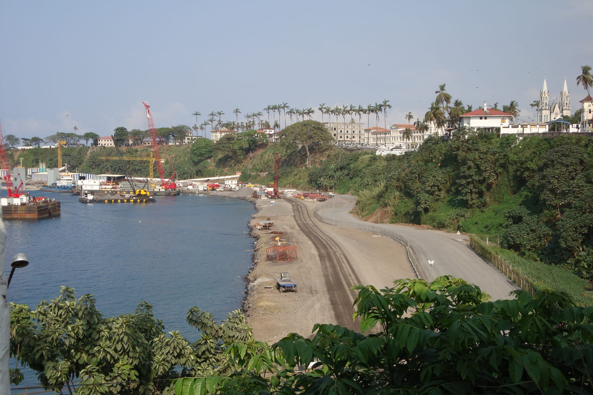
A curving harbour bay with cranes and a shoreline road, with buildings on the green slope above

Equatorial Guinea

Malabo

The port of Malabo, below the city's colonial centre. (ColleBlanche / Wikimedia Commons · CC BY-SA 4.0)

The largest city on the volcanic island of Bioko, founded by the British in 1827 as Port Clarence and known as Santa Isabel through the Spanish colonial period. It sits on Bioko's north coast below the slopes of Pico Basilé, and was the national capital until 2026. This page is written to explain the city, not to encourage travel.

Neighbourhoods

  • Centro Histórico
    • First-time visitors
    • Historic district
    • Architecture

    The old Spanish quarter on the bluff above the harbour, laid out in a grid of low colonial buildings with shutters and verandas around the cathedral and the main square. Ministries, banks and most of the older hotels are here, and it is the one part of the city made for walking.

    Open in Maps
  • Ela Nguema
    • Local life
    • Markets

    A busy residential quarter linked to the centre by the city's bus service, with its own church and football club, and small shops, street trade and food stalls along the main roads.

    Open in Maps
  • Sipopo
    • Beaches
    • Conference district

    The resort town built outside the city for the African Union summit hosted in 2011, designed for business visitors and conferences, away from the city's traffic.

    Open in Maps

Things to do

Landmarks in the centre

  • Malabo Cathedrallandmark

    The neo-Gothic Cathedral of Santa Isabel, built between 1897 and 1916, with its two 40-metre towers completed in 1927 — the largest church in the country, its roof damaged by fire in 2020.

    Open in Maps
  • Plaza de la Independencialandmark

    A square in the colonial centre, counted among the city's landmarks along with the cathedral, the city hall and the colonial-era Presidential Palace.

    Open in Maps
  • Malabo waterfront and harbourattraction

    The city's working port and its bay, close to the colonial centre.

    Open in Maps

Parks and viewpoints

  • Pico Basiléviewpoint

    The island's highest volcano and the country's highest peak, 3,011 metres high, close to the city; the mountain lies within Pico Basilé National Park, created in 2000.

    Open in Maps

Sport

  • Malabo Stadiumattraction

    The national football stadium, opened in 2007 and home ground of the national team, a host venue for the 2012 and 2015 Africa Cup of Nations.

    Open in Maps

Short trips from the city

  • Mokaneighborhood

    A small town in the south of the island, named after the nineteenth-century Bubi king Moka, with a wildlife centre and walks to the Iladyi Cascades (Moka Falls).

    Open in Maps
  • Lake Biaoattraction

    A crater lake, also called Lake Moka, in the caldera of Mount Biao about 4 km west of Moka, ringed by the volcano's steep slopes.

    Open in Maps
  • Lubaneighborhood

    The island's second town, a small port on the west coast with a quiet waterfront, the white-sand beach of Arena Blanca, about 4 km long, and the road south towards the crater reserve.

    Open in Maps
  • Urecaneighborhood

    A village on Bioko's remote southern coast, one of the wettest places in Africa, near beaches where sea turtles come ashore to nest.

    Open in Maps

Getting around

  • Malabo International Airporttransit hub

    The country's main airport, at Punta Europa west of the centre, and the required point of entry for e-visa holders.

    Open in Maps

Seasonal events

  • Independence DayOctober

    The anniversary of independence from Spain in 1968, marked with official parades and public events.

  • Semana SantaMarch or April

    Holy Week processions and church services in a strongly Catholic city, the most widely observed religious season of the year.

Eat and drink

Long-standing places and food districts in Malabo. Hours, ratings and directions come from your maps app, always current.

Malabo classics

  • Pepesuprestaurant

    The country's signature hot fish soup, sharp with chilli and pepper, served in small local eating places.

    Open in Maps
  • Grilled fish and plantainrestaurant

    Fish landed on Bioko, grilled over charcoal and eaten with fried plantain, cassava or rice, is the everyday meal of the city.

    Open in Maps

Markets and food streets

  • City marketsmarket

    The city's markets, where island produce — plantain, cassava, yam, peppers, fish and fruit — is traded.

    Open in Maps
  • Eating places of the Centro Históriconeighborhood

    The colonial grid holds most of the city's restaurants, a mix of Equatoguinean cooking, Spanish dishes and food for the oil-sector population.

    Open in Maps
  • Cafés and Spanish bakeriescafe

    Coffee, bread and pastries in the Spanish manner are a lasting colonial legacy, alongside locally grown coffee and cocoa.

    Open in Maps

Experience Malabo

History

The Bubi are the island's indigenous people, and they called the town that grew here Ripotó, the place of the foreigners. Portugal claimed Bioko — then called Fernando Pó — in the fifteenth century and ceded it to Spain in 1778. In 1827 Britain, allowed by Spain to use the island as a base against the Atlantic slave trade, founded a settlement on the ruins of an earlier Portuguese one and named it Port Clarence, resettling freed Africans there; their descendants became the Fernandino community.

Spain reasserted control in the mid-nineteenth century, revoking the British lease in 1855, and renamed the town Santa Isabel. It became the administrative centre of Spanish Guinea and the shipping point for the cocoa grown on Bioko's plantations, worked in large part by contract labour brought from elsewhere in West Africa, notably Liberia. A grid of low colonial buildings with shutters and iron verandas grew on the bluff above the harbour, and the cathedral was built between 1897 and 1916.

Independence came in 1968, and the city was renamed Malabo in 1973, after a former Bubi king. The first years of independence, under Francisco Macías Nguema, were catastrophic for the country and drove many of its people into exile; recovery began slowly after 1979. Offshore oil discovered in the mid-1990s transformed Malabo, bringing foreign companies, new districts inland, conference complexes and a building boom. In January 2026 a presidential decree moved capital status to Ciudad de la Paz, a planned city still under construction in the mainland forest.

Culture & Customs

Malabo stands on Bubi land and has always been a mixed city. The Bubi of Bioko, the Fernandinos descended from freed slaves and West African settlers, Fang families from the mainland, Nigerian and Cameroonian traders and a foreign oil-sector population all live in it, and Spanish is the common language between them, with Bubi, Fang and the English-based creole Pichi heard in the streets.

The Spanish colonial legacy runs deep in everyday manners: Spanish forms of address and greeting, Catholic practice, Spanish names and the rhythm of a Sunday. Holy Week and saints' days fill the cathedral, while Bubi custom persists alongside the church in matters of family, land and mourning, and the balélé dance is performed on Bioko around Christmas.

Public cultural life is restrained. Independent media and civil society are tightly restricted, state occasions dominate the public calendar, and much expression happens privately, in church halls or among the large diaspora in Spain. Football is the shared national enthusiasm; Malabo's stadium hosted matches when the country co-hosted and hosted continental tournaments. Visitors are commonly reminded, by residents as much as by officials, not to photograph anything official.

Daily Life

Malabo has roughly 300,000 residents, making it the largest city on Bioko and one of the two main urban centres of the country. Most people live not in the small colonial core but in the districts spreading out from it, such as Ela Nguema.

The economy runs on oil and gas administration, government employment, the port and the trade and services that follow them. The industry itself employs relatively few people directly, so most households live on public-sector wages, small trade, transport and market selling; the difference between the incomes of the oil sector and of ordinary residents is wide, and imported food is expensive. Power and water supply improved during the oil years but remain uneven, and the economic downturns of recent years are felt in construction and jobs.

The day starts early, before the heat and the afternoon rain. Markets open at first light, offices work through the morning, and the late afternoon brings street trade, football on any open ground, and people out along the seafront when it is dry. Rain dictates a great deal: heavy downpours empty the streets quickly and turn unpaved side roads to mud.

Food

Malabo eats Central African food with a Spanish accent. The bases are plantain, cassava, yam, rice and cocoyam, eaten with sauces built on groundnuts, palm oil and greens. Pepesup, a fiery fish soup, is the dish most associated with the country, and bambucha — crushed cassava leaves boiled with palm-kernel juice and spices — is the other standard. Fish is everywhere, given the city's position on the coast: grilled whole, smoked, or stewed with tomato and chilli.

Dishes adopted from elsewhere include the Cameroonian ndolé and the Spanish tortilla, and the Spanish legacy also shows in bread and pastries. Imported Spanish products — olive oil, tinned goods, wine — are common in the shops that serve the expatriate population, at import prices.

To drink there is malamba and topé, the palm wine of the country, alongside imported beer. Bioko's volcanic soil grew the cocoa that once paid for the colonial city; fruit from the island — pineapple, papaya, banana, avocado — fills the market stalls year round.

Planning tools

Budget

Malabo is very expensive and priced for the oil industry rather than for tourism. Hotels are few and costly, almost all food and goods are imported, and independent budget accommodation barely exists. Transport means taxis or a hired car with a driver.

Daily Budget Midrange
USD 200–400+ per day (hotel, hired car with driver, permits and meals)
Daily Budget Shoestring
USD 120–200 (the simplest guesthouse, local eateries and shared taxis; genuine budget travel is barely possible)

Arrange accommodation and ground transport before arriving, and carry CFA francs in cash; card acceptance is limited even in the city.

Best Time to Visit

December to February, the drier but still cloudy months on Bioko, are the most practical time, when the island's roads are least affected by rain. Rain is possible in any month.

Suggested Number of Days

The colonial centre is small and takes a day or two. Three or four days allow for the rest of the island, where roads are slow and rain can close tracks. Permits and paperwork can absorb more time than the distances do.

First Visit
1–2 days
With Surroundings
3–4 days

Transportation

Taxis are the usual way to move around the city and its outskirts, and a bus service runs between the centre and Ela Nguema; there is no urban rail. A road links Bioko's four main towns, and a hired vehicle with a driver is the normal way to reach Moka, Luba or Ureca.

Carry a passport and any permits at all times: military and police checkpoints are frequent on the island's roads.

Airport & Station Connections

Malabo International Airport lies at Punta Europa, west of the centre, with international and regional flights and frequent domestic flights to Bata on the mainland. Holders of the national e-visa have to enter the country at this airport. A ferry also links Bioko with the mainland coast, on a schedule that varies.

Walkability

The Centro Histórico is compact, flat on top of the bluff and pleasant to walk, with the cathedral, the square and the old streets within a few hundred metres of each other. Beyond it the city spreads out and pavements give way to roadside verges, so most journeys are by taxi. Heavy rain and humidity shorten any walk.

Safety

Violent crime against visitors is uncommon in Malabo and the streets are heavily policed, but the security presence itself is the main thing visitors notice, with checkpoints, document checks and strict limits on what may be photographed. Ordinary care against petty theft applies in markets and crowded areas.

Serious crime against visitors is uncommon, but Equatorial Guinea is a tightly controlled state with a heavy security presence, and the main risks are political and bureaucratic: arbitrary detention, harassment at checkpoints, and severe restrictions on photography and on any perceived criticism of the government. Check current official travel advice before travelling.

Climate

Tropical, and among the cloudiest and wettest of the world's capital cities: hot, humid and rainy through most of the year, with a short, drier but still cloudy spell from December to February. Temperatures vary little, averaging about 25°C, and the mountain behind the city is cooler.

Summer
the middle of the year is wet and humid, with September and October the wettest months; temperatures average about 25°C
Winter
December to February is the driest period, still cloudy and warm at about 25°C, and the easiest time for travel

Local Customs

Spanish is the language of public life, and greetings are formal and Spanish in style. Dress is neat and conservative; beachwear stays at the beach. Catholic practice is strong and churches are busy on Sundays. Political conversation in public is avoided, and photography is the most sensitive everyday issue for visitors.

Do not photograph government buildings, the presidential palace, the airport, the port, bridges, checkpoints or anyone in uniform, and ask before photographing people. Carry identification and permits at all times.

Common Payment Methods

The currency is the Central African CFA franc, pegged to the euro. This is largely a cash economy: cards are accepted at a small number of hotels and airline offices, ATMs are unreliable and often limited to local accounts, and euros in cash are the practical thing to bring and change.