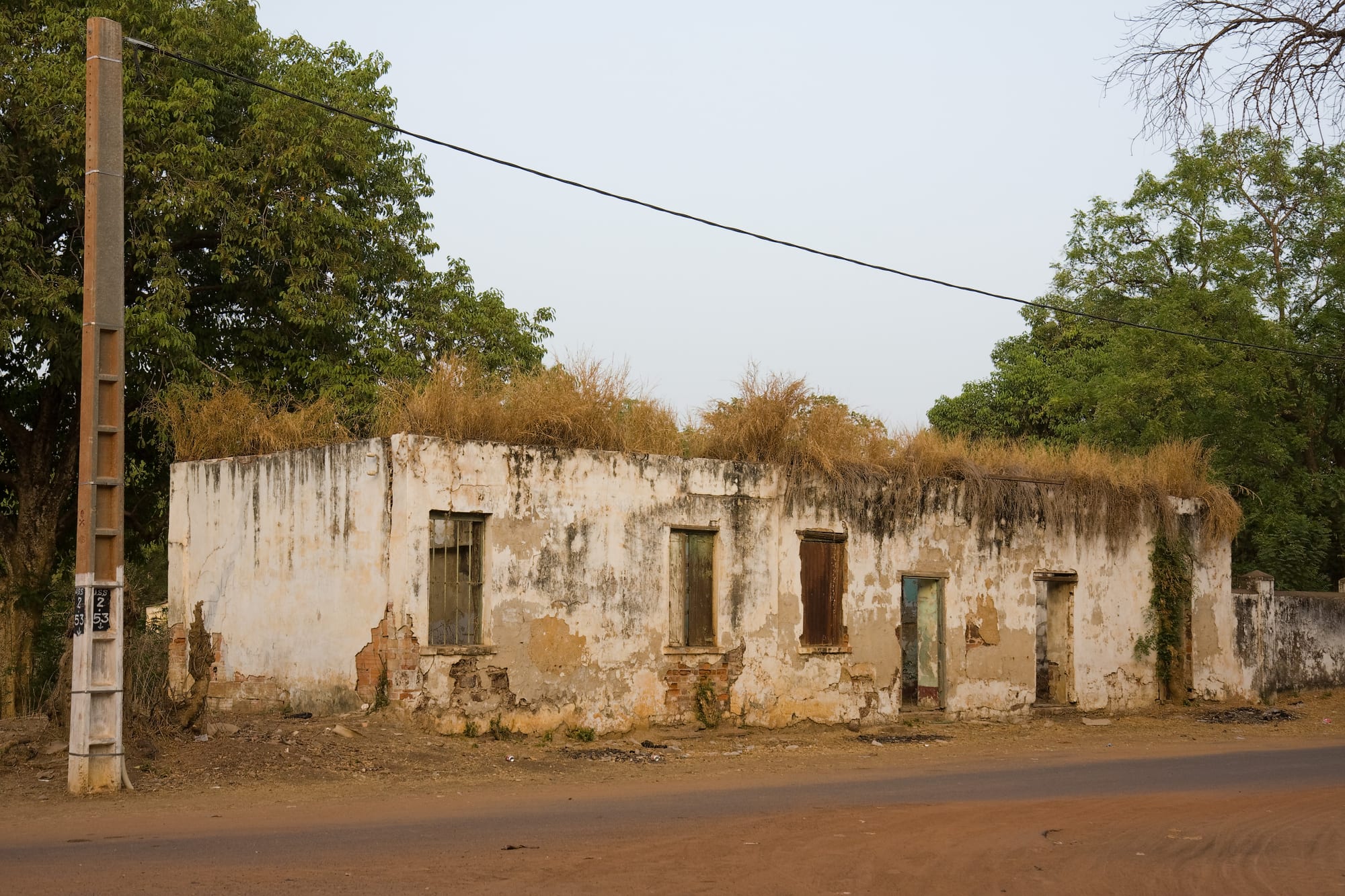
A roofless colonial trading house of whitewashed stone with boarded windows and grass growing along the top of its walls, beside a red dirt road

The Gambia

Janjanbureh

A ruined colonial trade house in the centre of Janjanbureh, long known as Georgetown. (Ikiwaner / Wikimedia Commons · CC BY-SA 3.0)

A small upriver town on an island in the Gambia River, about 270 km upstream from the river mouth. Founded by the British in 1823 and called Georgetown until 1995, it was a colonial administrative post and river port, and is now a quiet place of decayed trading houses, ferries and river trips, near the Wassu stone circles.

Neighbourhoods

  • The old town
    • Historic district
    • First-time visitors
    • Walks

    The sandy streets of the town itself, where the colonial administration built its offices, warehouses and mission. Several stone trading houses stand roofless among the compounds, and the town's few guesthouses, shops and the old Methodist church are within a short walk of each other.

    Open in Maps
  • The north ferry landing and Lamin Koto
    • River views
    • Transport

    The northern crossing point, where a vehicle ferry shuttles to the settlement of Lamin Koto on the opposite bank. It is the busiest spot on the island for much of the day, with lorries, minibuses and traders waiting for the crossing, and river views from the bank.

    Open in Maps
  • The eastern island villages
    • Quiet and residential
    • Local life

    Beyond the town the island is farmland and small villages of groundnut and rice growers, reached on sandy tracks. This is where most islanders live, and the rhythm is agricultural rather than administrative.

    Open in Maps

Things to do

The island town

  • The colonial trade houseslandmark

    Roofless stone warehouses and merchant buildings from the nineteenth-century river trade, standing among the compounds of the old town.

    Open in Maps
  • The bridge and the north-bank ferrytransit hub

    A bridge links the island to the south bank, while the government ferry and small boats cross to the north bank, the ways on and off for traffic on the two riverside roads.

    Open in Maps
  • The old Methodist churchlandmark

    The church of the Wesleyan mission established on the island in the 1830s, when the town was a settlement for liberated Africans.

    Open in Maps

The river

  • River boat tripsattraction

    Pirogues and small tour boats run from the island along the riverside forest, where baboons, monkeys, birds and the occasional hippo can be seen along the banks.

    Open in Maps

Short trips from the town

  • Wassu Stone Circleslandmark

    Megalithic circles of laterite pillars, with burial mounds nearby, about 22 km north-west of the north-bank landing, part of a UNESCO World Heritage Site inscribed in 2006 that spans four groups in the Gambia and Senegal, the other Gambian group being Kerr Batch.

    Open in Maps
  • River Gambia National Parkpark

    A park of forested river islands about 25 km downstream, home since 1979 to a chimpanzee rehabilitation project; the islands themselves may not be landed on, so the animals are watched from boats.

    Open in Maps
  • Kuntaurneighborhood

    A river town on the north bank about 20 km downstream, close to Wassu, whose port is the last inland point navigable by large commercial ships and a transit point for groundnuts.

    Open in Maps
  • Basse Santa Sumarket

    The easternmost major town in the country, about 70 km upriver, known for its important market and long a hub of regional trade.

    Open in Maps

Seasonal events

  • Koriteh and Tobaskivaries with the Islamic calendar

    Eid al-Fitr and Eid al-Adha, the year's biggest family celebrations, marked with prayers at the mosque, new clothes and shared meals across the island.

  • Independence DayFebruary

    The national day on 18 February, marked in upriver towns with school parades and local ceremonies.

  • The groundnut harvest and trading seasonNovember to February

    The dry months when the crop comes in, the markets and river landings are busiest and travel on the unpaved tracks is easiest.

Eat and drink

Long-standing places and food districts in Janjanbureh. Hours, ratings and directions come from your maps app, always current.

Where people eat

  • Janjanbureh market and food stallsmarket

    A small daily market with rice, dried and smoked fish, groundnuts, vegetables and cooked-food sellers who dish out benachin and domoda at midday.

    Open in Maps
  • Guesthouse kitchens by the riverneighborhood

    The handful of lodges and guesthouses along the river cook Gambian rice dishes and fresh river fish for their guests; there are very few standalone restaurants in the town.

    Open in Maps

Experience Janjanbureh

History

The island in the middle of the Gambia River was settled long before the British arrived, and the megalithic circles nearby show that the middle river supported organised societies more than a thousand years ago. In 1823 the British captain Alexander Grant acquired the island from Kolli Camara, king of Lower Niani, in exchange for annual payments, and named it MacCarthy Island after Sir Charles MacCarthy, governor of Britain's West African territories. The purpose was a settlement for freed slaves, guarded by a new fort, and by the 1840s it was the furthest upriver post the colonial administration controlled.

Liberated Africans taken from intercepted slave ships were resettled here, and a Wesleyan mission was established among them. From the 1830s the town grew around the mission as a trans-shipment point for groundnuts, rice and other crops sent downriver to Bathurst, and it became an administrative centre and the site of the country's main prison. Armitage High School, founded in 1927 to educate the children of colonial chiefs and wealthy families, is one of the oldest schools in the Gambia.

The town's importance waned as roads replaced the river as the main route east. It was renamed Janjanbureh in 1995, and today its ruined trade houses, its ferries and the wildlife of the surrounding river are what draw the small number of visitors who make the long trip east.

Culture & Customs

The town sits at a meeting point of Gambian peoples. Mandinka is the dominant language of the middle river, with Fula herders and traders, Wolof merchants and Serahule families, and the descendants of the liberated Africans who were settled here in the nineteenth century, some of them Christian. Islam is practised by the great majority, and the mosque, the Friday prayers and the two Eids set the shape of the year, while the Methodist church keeps a small congregation of long standing.

Village etiquette is more formal than on the coast. Greetings are extended and obligatory, elders are deferred to, and a visitor to a village is expected to present themselves to the alkalo. Hospitality to a stranger is a matter of pride even in poor compounds.

Music and ceremony here are less commercial than in the resorts. Griot families play the kora and sing the histories of lineages at naming ceremonies and weddings; drumming accompanies the harvest and the initiation seasons; and masquerade figures such as the kankurang, a masked protector associated with Mandinka initiation and recognised by UNESCO as intangible cultural heritage, appear at certain times of year. Photography of ceremonies is not always welcome, and permission is asked first.

Daily Life

Janjanbureh is a small place, the capital of a local government area of well over 100,000 people but itself only a modest town, and the atmosphere is rural rather than urban. Most households farm: groundnuts as the cash crop, rice in the low ground along the river worked largely by women, millet, maize and vegetable gardens, with cattle and goats kept in the compounds. Fishing the river adds protein and a little income, and a few families make a living from the guesthouses, boats and guiding.

The town's administrative role keeps a modest number of government jobs — schools, a health centre, the local council — but the departure of the river trade left little else, and young people leave for Serekunda, the coast or, in some cases, for Europe. Money sent home by relatives abroad supports many households. Electricity is intermittent, water comes from boreholes and standpipes, and the bridge and the ferry are the town's lifelines.

The day begins before dawn with prayer and work in the fields, pauses in the punishing midday heat, and resumes in the late afternoon, ending with the evening meal from a shared bowl and rounds of attaya brewed over charcoal. The market, the ferry landing and the shade of the big trees are the places where the town gathers and news travels.

Food

Upriver cooking is plainer than on the coast and built on what the fields and the river produce. Benachin, rice cooked in a tomato and fish or meat sauce with vegetables, and domoda, a groundnut stew poured over rice, are the two staples, made here with the groundnuts grown in the surrounding fields. Superkanja, an okra stew thickened with palm oil and smoked fish, and plain rice with a leaf or groundnut sauce fill out the week.

River fish is the everyday protein: catfish and tilapia caught nearby, and dried or smoked fish traded from the coast and used to season sauces. Away from the river the millet foods of the Sahel appear — chere, steamed millet served with groundnut or other sauces, and findi, the fine grain also called fonio, boiled or steamed. Mangoes weigh down the trees in the early rains, and cashew, baobab fruit and wild fruits are gathered in season.

Breakfast is often akara bean fritters or bread with a bean or groundnut filling, and tapalapa, the dense local baguette, is baked in wood-fired ovens. The social drink is attaya, the three sweet rounds of green tea brewed slowly over coals in the shade, with wonjo made from hibiscus, baobab juice and ginger drinks sold chilled at the market. Alcohol is scarce in this Muslim area and mostly confined to the river lodges.

Planning tools

Budget

Janjanbureh is among the cheapest places to stay in the Gambia: simple guesthouses and camps, market food and shared transport cost very little. The real expenses are getting here — a hired car with driver or a multi-day river boat — and chartering a boat for wildlife trips, which is priced per boat rather than per person.

Daily Budget Midrange
USD 60–130 (river lodge, a driver, a chartered boat trip)
Daily Budget Shoestring
USD 20–40 (basic guesthouse, market food, shared 'gelli-gelli' minibuses)

Bring enough dalasi in small notes from the coast; banking and card facilities upriver are very limited and changing large bills is difficult.

Best Time to Visit

November to February, when the roads and tracks are dry, the river is high after the rains and birdwatching is at its best. March to May is very hot inland, well above the coastal temperatures. From June to September rain makes some tracks difficult and many small operators shut down.

Suggested Number of Days

The town itself needs only a day. Two or three suit a stay that includes a boat trip on the river, the stone circles and the towns downstream. The long journey from the coast usually means at least one night here.

First Visit
1–2 days
With Surroundings
3 days

Transportation

A bridge joins the island to the south bank and ferries cross to the north bank, and shared bush taxis and 'gelli-gelli' minibuses run along the north- and south-bank roads to the coast and east to Basse. Within the town everything is walkable, with bicycles and the occasional taxi for the outlying villages, and boats are hired at the riverside for trips downstream.

Ferries and bush taxis run through the day rather than to a published timetable; travelling in the morning avoids waiting.

Airport & Station Connections

The island lies about 270 km up the river from its mouth, a long day by road from Banjul, reached by the bridge from the south-bank road or by ferry from the north bank. A hired car with driver is the usual way for visitors, and river cruises also run up the Gambia from the coast. Shared bush taxis are the local option and take longer.

Walkability

The old town is small, flat and entirely walkable: the church, the ruins, the market and the ferry landing are all within a kilometre. Streets are sand and laterite with no pavements, the heat is intense between late morning and mid-afternoon, and the outlying island villages are a long walk or a short ride away.

Safety

Upriver Gambia is quiet, with very little crime against visitors and none of the beach-front hassle of the coast. The practical risks are environmental: strong sun and heat inland, malaria, and the river itself, which holds hippos and should not be entered or approached closely from small boats.

The Gambia is generally safe and welcoming, with low levels of violent crime. Malaria precautions matter more here than on the coast, drinking water should be bottled or treated, boat trips are best taken with experienced local boatmen who keep a distance from hippos, and modest dress is expected in these strongly Muslim villages. Check current official travel advice before travelling.

Climate

Hotter and drier than the coast, without the sea breeze, with one rainy season and a long dry season. The Harmattan can bring dust and cooler nights between December and February, and the river rises and falls markedly with the rains.

Summer
the rains, roughly June to September — hot and humid, often 28–34°C, with heavy storms and difficult tracks
Winter
the dry season, November to February — warm, sunny days around 30–34°C and noticeably cool nights

Local Customs

This is a strongly Muslim, largely Mandinka and Fula area where village etiquette is taken seriously. Greetings come before any request, elders are greeted first, the right hand is used for eating and giving, and food is often shared from a common bowl. Visitors calling at a village are expected to greet the alkalo, the village head, or to be taken by a local guide.

Cover shoulders and knees, ask before photographing people or compounds, and accept tea or food if offered. Alcohol is little used and best kept to the lodges.

Common Payment Methods

The currency is the Gambian dalasi, and upriver the economy is almost entirely cash. There are few banks and ATMs east of the coast, and those that exist may be out of service or out of notes, so money is best changed before leaving Banjul or the resort strip. Cards are not accepted outside a few lodges, and mobile money is used locally.