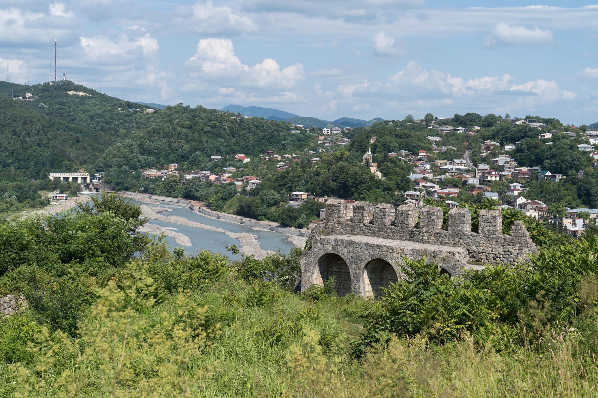
The Rioni river running past wooded hills and red-roofed houses in Kutaisi, seen over a ruined stone fortress wall with arches

Kutaisi, Batumi & Western Georgia, Georgia

Kutaisi

Kutaisi and the Rioni river seen from the walls on Ukimerioni Hill. (Alexkom000 / Wikimedia Commons · CC BY 4.0)

Georgia's third city and the historic capital of Imereti, set where the Rioni river leaves the foothills of the Caucasus in the west of the country. One of the oldest continuously inhabited cities in the region, it was the seat of Colchian and later Georgian kings, and today combines a low-rise centre of nineteenth-century streets with the monasteries, caves and canyons of the surrounding hills.

Neighbourhoods

  • Central Square and Rustaveli Avenue
    • First-time visitors
    • Central
    • Close to public transport

    The heart of the city, built around a circular square with the Colchis Fountain and its gilded animal figures, the drama theatre and the main shopping street running off it. Most hotels, cafés and bus departures are within a few minutes' walk.

    Open in Maps
  • The riverside and the White Bridge
    • Walks
    • Historic district
    • Cafés

    The banks of the Rioni below the centre, linked by a cluster of bridges including the slender pedestrian White Bridge. Nineteenth-century houses with carved balconies line the streets that climb away from the water, and paths follow the river past weirs and rapids.

    Open in Maps
  • Ukimerioni and Bagrati hill
    • Views
    • Historic district
    • Quiet

    The high ground on the right bank, crowned by the ruined fortress and the great stone mass of Bagrati Cathedral. Steep lanes of family houses and gardens climb to the top, which gives the best view over the city and the plain.

    Open in Maps
  • The bazaar quarter
    • Best for food
    • Local life
    • Markets

    The blocks around the main market north of the centre, busy with produce stalls, spice sellers, cheap canteens and minibus stands. It is the most crowded and workaday part of the city, and the place to see Imeretian produce.

    Open in Maps
  • Sapichkhia and the western districts
    • Quiet and residential
    • Close to the airport road

    Residential areas spreading west from the river towards the airport road, mixing Soviet apartment blocks with streets of single-storey houses and vineyards in the yards. Prices are lower and the atmosphere is local rather than touristic.

    Open in Maps

Things to do

Churches and landmarks

  • Bagrati Cathedrallandmark

    The cathedral built by Bagrat III, its floor laid in 1003, devastated by an Ottoman cannonball in 1692 and reconstructed in stages from the 1950s until 2012 — works that led UNESCO to remove it from the World Heritage list.

    Open in Maps
  • Colchis Fountainlandmark

    The fountain at the centre of the main square, ringed with enlarged gilded copies of animal figures of the kind excavated at Colchian sites such as Vani.

    Open in Maps
  • Kutaisi Synagoguelandmark

    A nineteenth-century synagogue in the old Jewish quarter, built in 1885, a reminder of a Jewish community long established in the city.

    Open in Maps
  • Kutaisi Botanical Gardenpark

    A garden on the right bank known for its old specimen trees and a small chapel set into a hollow trunk.

    Open in Maps

Museums

  • Kutaisi State Historical Museummuseum

    The city's main museum, formally the Niko Berdzenishvili Kutaisi State History Museum, holding archaeological and ecclesiastical collections from across Imereti alongside a large research library.

    Open in Maps

Monasteries above the city

  • Gelati Monasterylandmark

    Founded by King David IV, the Builder, in 1106 as a monastery and academy, a UNESCO World Heritage Site whose main church was completed in 1130 and holds Byzantine-style mosaics and extensive frescoes.

    Open in Maps
  • Motsameta Monasterylandmark

    A small monastery on a cliff above a bend of the Tskaltsitela river, named for David and Constantine, eighth-century brothers from Argveti who led a revolt against Arab rule and are venerated as martyrs, their relics kept there.

    Open in Maps

Caves, canyons and short trips

  • Prometheus Caveattraction

    A large karst cave at Kumistavi north-west of the city, in Tsqaltubo Municipality, with about 1.8 kilometres of lit galleries open to visitors and an underground river running through the system.

    Open in Maps
  • Sataplia Managed Reservepark

    A wooded reserve about 10 kilometres from the city on the slopes of the extinct volcano Mount Sataplia, with fossilised dinosaur traces, a karst cave and a glass observation deck above the cliff.

    Open in Maps
  • Tskaltuboattraction

    A spa town about 9 kilometres west, known for radon-carbonate springs warm enough to be used unheated and for the Soviet sanatoriums ringing its park, many now derelict and some housing people displaced by the conflict in Abkhazia.

    Open in Maps
  • Martvili Canyonattraction

    A gorge on the Abasha river in Samegrelo, about 2.4 kilometres long and up to 70 metres deep, with deep green water, waterfalls and a limestone stairway once used by the Dadiani family.

    Open in Maps
  • Okatse Canyonattraction

    A narrow canyon on the Okatse river near Zeda Gordi, reached from a visitor centre at Gordi and visited on a 780-metre trail hung from the cliff above the water.

    Open in Maps
  • Vaniattraction

    An archaeological site and museum south-west of the city, the best studied settlement of ancient Colchis, where local goldwork and imported Greek pottery were excavated.

    Open in Maps
  • David the Builder Kutaisi International Airporttransit hub

    The low-cost gateway to western Georgia, on the plain 14 kilometres west of the city and the second busiest airport in the country, with scheduled buses to the city, Batumi and Tbilisi.

    Open in Maps

Seasonal events

  • Kutaisoba2 May

    The city's own holiday, also called Gviriloba and held each year on 2 May since the 1980s, with folk music, traditional dancing and street events in the centre.

  • Rtveli, the grape harvestmid-October

    The harvest season in the villages of Imereti around the city, when families press grapes and the year's wine goes into buried clay vessels.

Eat and drink

Long-standing places and food districts in Kutaisi. Hours, ratings and directions come from your maps app, always current.

Markets and food districts

  • Kutaisi central bazaarmarket

    The city's sprawling market, where Imeretian cheese, churchkhela, spices, honey, greens and seasonal fruit are sold, with cheap canteens and bakeries around its edges.

    Open in Maps
  • Restaurants around Central Squareneighborhood

    The concentration of restaurants, wine bars and cafés in the streets radiating from the main square, serving Imeretian cooking and Georgian standards.

    Open in Maps
  • Bakeries with tone ovensneighborhood

    Small neighbourhood bakeries all over the city bake shoti bread against the walls of a clay tone oven and sell it hot through a window.

    Open in Maps

Experience Kutaisi

History

Kutaisi is among the oldest cities in Georgia, and archaeology points to settlement on the Rioni long before it appears in writing. It was the political centre of Colchis, the kingdom that Greek tradition attached to the story of the Golden Fleece, and the gold and bronze objects found at nearby Vani show how wealthy that society was. In about 786 Leon II moved the capital of the kingdom of Abkhazia here, and it remained the seat of kings who ruled western Georgia, and when Bagrat III inherited both western and eastern lands around the year 1000 Kutaisi became the capital of a united Georgian kingdom, which it remained until 1122. Bagrati Cathedral, whose floor was laid in 1003, and Gelati Monastery, founded by David the Builder in 1106 as a church and a school, date from that period.

After the united kingdom broke apart in the fifteenth century the city remained the capital of the separate kingdom of Imereti, which stood between Ottoman and Persian power and was annexed by the Russian Empire in 1810. Ottoman troops wrecked the cathedral with a cannonball in 1692, leaving it a ruin for centuries.

Under Russian and then Soviet rule Kutaisi became a provincial capital and an industrial town, with a large truck factory, engineering works and a railway junction. Industry collapsed after independence in 1991, and the city lost jobs and people. From October 2012 until December 2018 the Parliament of Georgia sat in a new building on the edge of the city, before a new constitution returned it to Tbilisi; the airport and the restored cathedral date from the same period of investment.

Culture & Customs

Kutaisi carries itself as an old capital rather than a provincial town, and residents are quick to point out that the city was a seat of kings when Tbilisi was a frontier post. The identity is Imeretian: talkative, musical and attached to the table. Western Georgian polyphonic singing is sung here in a style distinct from the eastern one, and choirs, the drama theatre named after Lado Meskhishvili, and the city's opera and puppet stages have long histories.

Religion is central to public life. Gelati was the intellectual centre of medieval Georgia, where philosophy and theology were taught, and it remains a working monastery with its academy ruins beside it; Motsameta draws pilgrims to the tomb of two brothers venerated as martyrs. The city also had a long-established Jewish community, concentrated around its synagogues, one of them built in 1885; emigration in the later twentieth century reduced it, but the buildings and the street names remain.

Hospitality follows Georgian form: guests are fed generously, toasts are proposed in sequence by a tamada and drunk in full, and a refusal is taken as coolness rather than restraint. Football is followed closely, the local club Torpedo Kutaisi being the second most successful in Georgian history. Markets are places for conversation and bargaining, and the pace of the day, slower than in Tbilisi, is something residents defend.

Daily Life

About 160,000 people live in Kutaisi, making it the third largest city in Georgia after Tbilisi and Batumi, and many households have relatives working in the capital or abroad. Households spread across the low-rise streets of the centre, the hillside lanes below the fortress and the blocks of flats in the western and northern districts, and remittances from relatives working overseas support many of them.

The economy rests on three things: the airport and the tourism it brought, which turned the centre into a place of guesthouses, hostels and car-hire offices; trade, from the bazaar to small workshops; and public employment in schools, the university and hospitals. The Soviet factories that once defined the city, above all the truck plant, are largely gone, and unemployment remains a problem. Farming in the surrounding villages supplies the markets with vegetables, fruit, maize and wine.

The day starts early at the bazaar and around the bread ovens, slows in the afternoon heat of summer, and picks up in the evening, when the square, the riverside and the cafés fill and families walk. Traffic, air quality, the state of the pavements and the loss of old wooden houses are recurring local complaints, along with the question of how much of the airport's traffic actually stays in the city rather than moving straight on to Batumi or Tbilisi.

Food

Imereti has its own cooking, lighter and more herb-led than the eastern Georgian kitchen, and Kutaisi is the place to eat it. The regional cheese, Imeretian sulguni's fresher cousin, goes into imeruli khachapuri, a flat round cheese bread quite different from the boat-shaped Adjarian version served on the coast. Herbs, walnuts and tart flavours run through the rest: satsivi, poultry in a cold walnut sauce eaten at festivals; badrijani nigvzit, aubergine rolls filled with walnut paste; pkhali, vegetables chopped with walnuts, garlic and herbs and served cold; and ajapsandali, a stew of aubergine, pepper and tomato.

Maize rather than wheat was the staple of western Georgia, and it survives in ghomi, a stiff maize porridge served hot with cheese melting into it, and in mchadi, dense maize bread. Bread elsewhere means shoti, baked against the wall of a clay tone oven. Chicken with garlic sauce, spicy kharcho and trout from the hill rivers are common on menus.

Imereti is a wine region in its own right, working with grapes such as tsitska, tsolikouri and krakhuna, and some producers still ferment in buried clay qvevri. Churchkhela, walnuts threaded on string and dipped in thickened grape juice, hangs in every market, and chacha, the grape spirit, closes many meals.

Planning tools

Budget

Kutaisi is one of the cheapest cities in Georgia for accommodation and food, and the low-cost airport means many people arrive on an inexpensive flight. The main variable costs are day trips: the caves, canyons and monasteries are scattered, and a hired car with a driver for a day is usually the largest single expense.

Daily Budget Midrange
USD 55–110 (central hotel or good guesthouse, restaurant meals, entry tickets and a shared driver for the sights around the city)
Daily Budget Shoestring
USD 20–40 (hostel bed or simple guesthouse, bakery and market food, city minibuses)

Entry to the monasteries is free, and joining other travellers for a driver to the canyons and caves cuts the cost of the sights outside town sharply.

Best Time to Visit

May, June, September and October are the most comfortable months, with warm days, green hills and the harvest in autumn. July and August are hot and humid, which makes the caves and canyons popular and the hill walks heavy going. Winters are mild and wet rather than cold, and the city is quiet and cheap then.

Suggested Number of Days

One or two days cover the centre and the hill above it. Three or four allow the monasteries, caves and canyons within reach by road, and longer if the city is used as a base for western Georgia as a whole. Distances are short but roads are slow.

First Visit
1–2 days
With Surroundings
3–4 days

Transportation

The centre is small enough to walk. Beyond it, yellow city buses and minibuses run to the outer districts and to nearby villages for a flat fare paid with a card or in cash, and taxis are cheap and plentiful. Almost every visitor uses a taxi or a hired driver for the monasteries, caves and canyons, since public transport to them is sparse and slow.

Agree a taxi fare before getting in unless the driver uses an app, and arrange day trips through a guesthouse if sharing a car with others.

Airport & Station Connections

David the Builder Kutaisi International Airport lies on the plain about 14 kilometres west of the city and is the main base for low-cost flights from Europe, with shuttle buses to the city, Tbilisi and Batumi. Trains run from Tbilisi to a station a short way from the centre, and marshrutka minibuses connect Kutaisi with Tbilisi, Batumi, Zugdidi and the mountain roads north in three to four hours.

Walkability

The centre is compact, flat along the river and easy to cross on foot, with the square, the bazaar and the bridges within about twenty minutes of each other. Pavements are uneven, parked cars block them, and the climb to the fortress and Bagrati Cathedral is steep. The sights outside the city are too far to walk.

Safety

Kutaisi is a safe city by regional standards, with low levels of violent crime and a visible police presence. The everyday hazards are traffic — drivers are assertive and crossings are not always respected — along with uneven pavements, poorly lit streets, stray dogs and the slippery paths and stairways at the canyons and caves after rain.

Take care crossing roads, use marked paths at the canyons, and treat the derelict sanatorium buildings at Tskaltubo as unsafe to enter, remembering that people live in some of them. Check current official travel advice before travelling.

Climate

A humid subtropical climate, warmer and much wetter than eastern Georgia, with rain spread through the year and heavy downpours in late autumn and winter. Snow falls occasionally but rarely lies for long in the city.

Summer
hot and humid — July and August days commonly around 30°C, with thunderstorms
Winter
mild and wet — January days usually around 5–10°C, with frost at night and occasional snow

Local Customs

The supra, the Georgian feast led by a toastmaster, is taken seriously, and guests are pressed to eat and drink more than they intend. Churches and monasteries are active: women cover their heads and wear skirts, which are usually available at the door, men avoid shorts, and photography inside is often restricted. Older residents speak Russian as a second language, and younger ones increasingly English.

Tipping is modest — rounding up or about 10 per cent where no service charge appears on the bill — and it is polite to ask before photographing worshippers or market traders.

Common Payment Methods

The currency is the Georgian lari. Cards are accepted in hotels, restaurants and larger shops, and cash machines are common in the centre, but market stalls, bakeries, minibuses and village churches work in cash, so small notes are worth carrying.