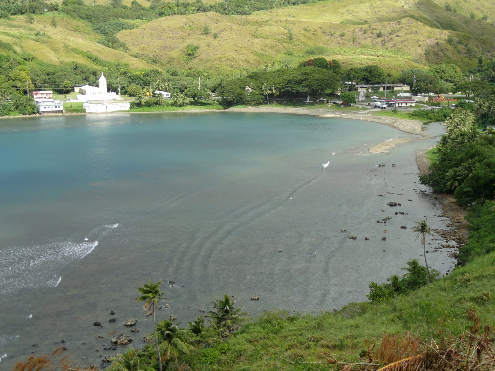
A curving bay of pale green water below steep grassy hills, with a white church and a few low buildings along the shore

Guam

Umatac

Umatac Bay, with the village church on the northern shore, seen from the hillside above. (Daderot / Wikimedia Commons · CC0)

A small village on Guam's south-western coast, set around a sheltered bay that Spanish galleons once used and that tradition names as the landing place of Magellan's fleet in 1521. A ruined Spanish fort stands on the cliff above it, and green hills rise behind a community of a few hundred people.

Neighbourhoods

  • The village and the bay
    • First-time visitors
    • Historic district
    • Quiet and residential

    A few streets of concrete houses, a church, a plaza and a monument by the shore, all within a couple of hundred yards of the water. The bay is shallow and grey-green where the river meets it, and village life is visible from the road.

    Open in Maps
  • Fort Soledad and the southern headland
    • Views
    • Walks and viewpoints

    The cliff on the far side of the bay, reached by a short road above the village, where the walls of a Spanish fort look out over the water and down the coast. It is the most visited spot in the village and open to the wind.

    Open in Maps
  • The inland hills
    • Hiking
    • Views

    The ridge behind the coast road, sparsely settled sword-grass country rising to Guam's highest points. Trails climb from the roadside to summits and crosses with views over the reef, and the hills are burnt brown in the dry season and green after the rains.

    Open in Maps
  • Merizo and the south coast
    • Beaches
    • Boats and snorkelling
    • Local life

    The neighbouring villages around the island's southern tip, a short drive away, with calmer swimming water, a pier for boats to the reef, fishing families and a string of small churches and memorials along the road.

    Open in Maps

Things to do

The village

  • Fort Nuestra Señora de la Soledadlandmark

    A small Spanish fort of about 1802–1819 on the cliff above Umatac Bay, the last of four works that guarded the galleon anchorage, with a wide view of the coast.

    Open in Maps

Hills and coast nearby

  • Mount Lamlamviewpoint

    Guam's highest point at about 1,330 feet, climbed by a short grassy trail from the coast road north of the village.

    Open in Maps
  • Cetti Bayviewpoint

    An undeveloped bay north of Umatac, seen from a roadside overlook above steep hills that drop to the reef.

    Open in Maps

Short trips from the village

  • Cocos Islandbeach

    A low islet on the reef off the island's southern tip, reached by boat from Merizo, with sand, lagoon water and snorkelling.

    Open in Maps
  • Inarajanneighborhood

    The best-preserved of Guam's Spanish-era villages on the south-east coast, with pre-war houses, a pre-war church and the Gef Pa'go cultural village.

    Open in Maps
  • War in the Pacific National Historical Parkattraction

    Sites along the west coast north of the village, including the 1944 landing beach and gun positions at Agat's Ga'an Point.

    Open in Maps
  • Talofofo Fallsattraction

    Waterfalls in the southern interior, near the jungle cave where the Japanese soldier Shoichi Yokoi hid until 1972.

    Open in Maps

Seasonal events

  • Discovery DayMarch

    Guam's holiday on the first Monday of March, established for the 1521 arrival of Magellan's ships and now a celebration of CHamoru culture, is centred on Umatac, with dancing, food stalls and a village fair.

  • San Dionisio village fiestaOctober

    The fiesta for the village's patron saint, with mass, a procession and open houses where families lay out large spreads of food for neighbours and visitors.

  • Liberation DayJuly

    The territorial holiday on 21 July, marking the 1944 recapture of the island, brings village entries to the parade in the capital and celebrations at home.

Eat and drink

Long-standing places and food districts in Umatac. Hours, ratings and directions come from your maps app, always current.

Where people eat in the south

  • Umatac's stores and barbecue standsneighborhood

    The village has small shops and occasional roadside barbecue rather than restaurants, selling grilled ribs and chicken with red rice at weekends and around fiestas.

    Open in Maps
  • Merizo and Agatneighborhood

    The nearest choice of small CHamoru and Filipino eateries, bakeries and takeaways, spread along the coast road either side of the village.

    Open in Maps
  • Chamorro Villagemarket

    The market in the capital, about forty minutes north, whose night stalls are the easiest place to try kelaguen, red rice, coconut sweets and grilled meat in one go.

    Open in Maps

Experience Umatac

History

Umåtac — spelled Humåtak in CHamoru — was one of the substantial villages of pre-contact Guam, set where a river runs into a bay that gave canoes shelter and fresh water. Tradition and the earliest chronicles place the landfall of Ferdinand Magellan's expedition here in March 1521, after the first crossing of the Pacific, although historians have argued for other points on the island; a monument by the shore records the claim and the village has built a holiday around it.

Under Spanish rule the bay mattered out of proportion to the size of the place. Manila galleons crossing between Mexico and the Philippines called for water and provisions, and to guard that anchorage the colonial government fortified the entrance, building small batteries on the headlands and, early in the nineteenth century, Fort Nuestra Señora de la Soledad on the southern cliff. Umatac was for a time the island's second town, with a church, a plaza and a Spanish garrison.

The galleon trade ended, the United States took Guam in 1898, and the village settled back into fishing and farming. Japanese occupation from 1941 fell hard on the southern villages, with forced labour and, in the last weeks before the American recapture in July 1944, killings of civilians from nearby Merizo that are commemorated at village memorials. Post-war rebuilding in concrete replaced most of the old houses, and young people left for the centre and north of the island or for the mainland. What remains is a small, strongly CHamoru community that keeps the fort, the monument and the March festival.

Culture & Customs

Umatac is known across Guam for Discovery Day, held each March, when the shore below the monument fills with dancing, food stalls and a fair. The event carries a double edge that islanders discuss openly: it marks the moment the outside world arrived, and the beginning of colonisation, and the tone of the commemoration has shifted over the years towards CHamoru performance and history rather than celebration of the explorers.

Village life is Catholic and organised around the church of San Dionisio. The patron's fiesta brings mass, a procession and open houses where families cook for days and feed anyone who comes; contributions of food, money or labour flow through the chenchule' system that binds relatives and neighbours. Funerals draw nine nights of rosary, and the whole village turns out.

The south is also where CHamoru cultural revival is strongest: language use is higher than in the north, canoe-building, weaving and chant groups are active in the southern villages, and traditional fishing rights over particular reef flats are still respected. Visitors are received with courtesy and curiosity, and the expectations are simple — greet people, ask before photographing, drive slowly past houses, and do not treat the village as a stage set.

Daily Life

Umatac is home to a few hundred people, which makes it the least populated of Guam's nineteen villages. Housing is mostly single-storey concrete built or rebuilt after typhoons, strung between the coast road and the hillside, with the mayor's office, an elementary school, the church and a community centre forming the public heart of the place.

There is little paid work in the village. Most households depend on jobs in the centre and north of the island — government offices, hospitals, hotels, construction, the military bases — which means a daily commute of forty minutes or more each way on Route 2, and many families also run a boat or a garden. Fishing on the reef and in the deeper water offshore supplements what the shops sell, and pigs and chickens are kept behind houses for fiestas.

The day starts early because of the commute and the heat, and quietens by mid-evening. Weekends belong to church, family gatherings, barbecues, sport at the village court and fishing. The pressures are those of a rural community at the edge of a US territory: the cost of shipped-in food and fuel, young people leaving for Hawaii and the mainland, thin health and transport services, and the seasonal work of preparing for typhoons, with shutters, generators and stocked larders. Coastal erosion and flooding at the river mouth are a growing worry.

Food

Food in the south is home cooking rather than restaurant cooking, and it is at its fullest at fiestas. The table is built on grilled meat and rice: short ribs and chicken cooked over wood, hineksa' aga'ga' (red rice coloured with achote seed), and kelaguen, in which chicken, beef, reef fish or shrimp is chopped fine and cured in lemon juice with grated coconut, onion and hot donne' peppers. Finadene', the dipping sauce of soy, lemon or vinegar, onion and chilli, is on every table.

Reef and ocean fish are central here in a way they are not on the hotel strip — parrotfish, rabbitfish, tuna and mahi-mahi, grilled whole, salted, or served raw with coconut and lime. Kå'du, a light soup of fish or chicken with greens and coconut milk, and estufao, a Spanish-derived stew of meat with vinegar and onions, are everyday village dishes. Taro, breadfruit, yams and green bananas come out of household gardens.

Southern sweets are worth looking out for at fiestas and roadside stalls: apigigi, grated coconut wrapped in a banana leaf and roasted; guyuria, hard coconut cookies; latiya, custard over sponge cake with cinnamon; and coconut candy boiled down until it sets. Fresh coconuts are opened to drink, and tuba, fermented coconut toddy, is still made in the villages.

Planning tools

Budget

Umatac has almost no tourist infrastructure, so costs are set by wherever a visitor sleeps — normally the hotel strip at Tumon — plus a hire car and fuel for the drive south. The village itself is nearly free to see: the fort, the monument, the bay and the hill trails cost nothing, and food in the south is cheap when it is available at all.

Daily Budget Midrange
USD 180–350 (Tumon hotel, restaurants, hire car and fuel, a boat or dive trip)
Daily Budget Shoestring
USD 80–130 (guesthouse in the centre of the island, shop and barbecue food, a shared hire car)

Carry water, snacks and a full tank when driving the southern loop, as shops and fuel stations are few and often shut early.

Best Time to Visit

January to May, the dry season, is the best time for the coast road, the fort and the hill trails, which turn slippery and overgrown in the rains. March brings the Discovery Day festival, the village's busiest weekend. July to November is wetter and greener, and is also the typhoon season.

Suggested Number of Days

The village, the fort and the monument take a couple of hours. A full day suits the whole southern coast, and two days allow a hill walk and a boat trip as well. Rain, heat and the state of the trails change the pace more than distance does.

First Visit
Half a day
With Surroundings
1–2 days

Transportation

A hire car is effectively necessary. Route 2 runs along the west coast through the village and round the south of the island, a slow and scenic two-lane road. The island bus reaches the southern villages only a few times a day, taxis are scarce and ride-hailing barely operates here. Traffic drives on the right.

The southern loop road is narrow with blind bends and roadside parking at the overlooks; watch for pedestrians, dogs and water across the road after heavy rain.

Airport & Station Connections

A. B. Won Pat International Airport at Tamuning is about 20 miles north, roughly forty-five minutes to an hour by car depending on traffic through the capital. Nearly everyone arrives by hire car on a drive round the south of the island; the village is a stop on that loop rather than a destination people fly to.

Walkability

The village is small enough to walk end to end in a few minutes, and the bay, the church and the monument are all on foot from a roadside parking spot. The fort is a short steep climb or a short drive above the bay. Beyond that, the coast road has little pavement and the hill trails are unshaded, so anything further needs a car or proper walking gear.

Safety

The village is quiet and crime is rare, with break-ins to cars parked at overlooks and trailheads the usual complaint. The hazards are natural: strong currents and surf outside the reef, a sharp drop-off at the bay mouth, sun and heat on the treeless hill trails, and flash flooding on the river and coast road during heavy rain.

Leave nothing visible in a parked car, tell someone before walking the hill trails, take plenty of water, and ask locally before swimming anywhere outside the reef. Check current official travel advice before travelling.

Climate

Tropical, hot and humid all year, with highs usually in the mid-80s °F and only small seasonal change. The dry season, about January to May, leaves the southern hills brown; the wet season from July to November brings heavy showers, green slopes and the risk of typhoons.

Summer
hot, humid and wet — highs near 87°F, heavy afternoon rain, and the typhoon season under way
Winter
the dry season — highs near 85°F, brisk trade winds, brown hillsides and the clearest views from the fort

Local Customs

The south is the most CHamoru part of Guam, and village manners matter here. Greet people, greet elders first, and accept that mangnginge' — taking an elder's hand to the face to sniff it — is a normal courtesy. Fiestas are open-house occasions where guests are fed generously and a small contribution is appreciated. Sunday mornings belong to church. Beachwear is for the beach, not the village street.

Ask before photographing houses, fiestas or funerals, ask before crossing land or fishing on a reef flat that a family holds by custom, and treat latte stones and burial sites as sacred. Tipping is customary in restaurants and the drinking age is 21.

Common Payment Methods

The currency is the US dollar. Cash is what works in the south: village shops, barbecue stands and market stalls may not take cards, and the nearest reliable ATMs are in the larger villages and shopping centres to the north. Fuel stations and the bigger stores accept cards.