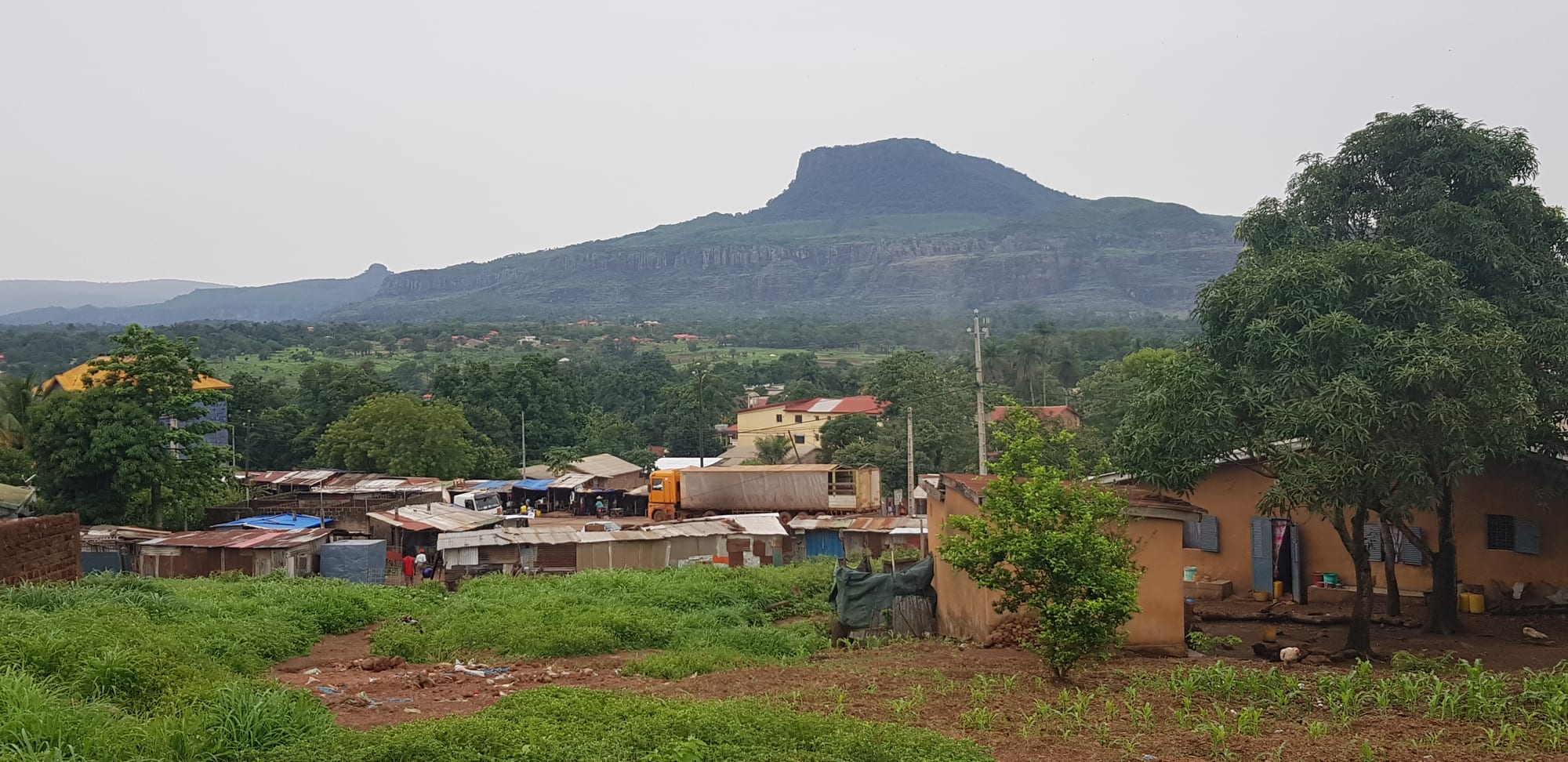
Green fields, leafy trees and tin-roofed houses below the flat-topped massif of Mount Gangan under a grey sky

Conakry & Lower Guinea, Guinea

Kindia

Mount Gangan, the flat-topped massif above Kindia, seen from the hill at Damakania. (Siddiq Diallo / Wikimedia Commons · CC BY-SA 4.0)

A market town in the green hills of Lower Guinea, on the road that climbs inland from Conakry towards the Fouta Djallon. It grew with the railway and with fruit farming, and is known for the waterfalls in the forested country around it and for the rock domes of Mount Gangan above the town.

Neighbourhoods

  • The town centre
    • First-time visitors
    • Markets
    • Local life

    The few busy streets around the market, the prefecture offices, banks and small hotels. Traders, taxis and loading yards make it the point everything in the district passes through.

    Open in Maps
  • The railway quarter
    • Historic district
    • Quiet and residential

    The older part of town laid out along the line from Conakry, with the station, railway housing and colonial-era buildings among mango trees. It is quieter than the market streets and shows the town's origins.

    Open in Maps
  • The road out to the falls
    • Waterfalls
    • Countryside
    • Quiet and residential

    The western approach out of town, where it thins into orchards, market gardens and villages below wooded ridges, and the tracks to the waterfalls turn off.

    Open in Maps
  • The Mount Gangan side
    • Walks and viewpoints
    • Quiet and residential

    The northern and eastern edges of the town beneath the massif, where compounds give way to farmland and footpaths climb towards the rock domes and viewpoints.

    Open in Maps

Things to do

Waterfalls and hills

  • Voile de la Mariéeattraction

    The Bridal Veil falls, a thin sheet of water dropping down a rock face in forest a short drive from the town, the best-known sight in the district.

    Open in Maps
  • Mount Ganganviewpoint

    The massif rising above Kindia to about 1,100 m, with weathered sandstone domes and cliffs, and long views over the plain towards the coast.

    Open in Maps
  • Tabouna fallsattraction

    A waterfall in the hills of the Kindia commune, fullest at the end of the rains.

    Open in Maps

In the town

  • Kindia marketmarket

    The central market, where the fruit and vegetables of the surrounding hills are traded and loaded for Conakry, alongside cloth, hardware and household goods.

    Open in Maps
  • The railway stationtransit hub

    The station on the line built from Conakry towards Kankan, around which the modern town grew; that line is now closed, and rail traffic in the district is the bauxite railway opened in 1972 between Kindia and the port at Conakry.

    Open in Maps

Short trips from the town

  • Coyahattraction

    A town on the road towards Conakry, known across Guinea for the mineral water that carries its name, and long a salt-producing area.

    Open in Maps
  • Mamouattraction

    The town in a valley of the Fouta Djallon where the road from the coast reaches the highlands, east of Kindia.

    Open in Maps

Eat and drink

Long-standing places and food districts in Kindia. Hours, ratings and directions come from your maps app, always current.

Markets and food streets

  • Kindia marketmarket

    Pineapples, bananas, oranges, avocados and vegetables from the surrounding hills, with rice, smoked fish and palm oil, and cooked food sold at the edges.

    Open in Maps
  • The roadside kitchens on the Conakry highwayneighborhood

    Simple eating houses and grills along the main road through town, feeding drivers and traders on rice and sauce, brochettes and tea at most hours.

    Open in Maps

Lower Guinea classics

  • Rice with sauce feuillerestaurant

    Rice under a dark sauce of pounded cassava leaves cooked with palm oil and fish or meat, the everyday meal of the region.

    Open in Maps
  • Fruit from the hillsmarket

    Pineapple, mango, orange and banana sold by the roadside and at the market, the produce that made the district's name in Conakry.

    Open in Maps

Experience Kindia

History

Kindia stands in Susu country on the route between the coast and the Fouta Djallon, a corridor used for trade in kola, cattle, salt and captives long before the colonial period. The modern town, however, dates from the railway. When the French built the line from Conakry towards Kankan in the first years of the twentieth century, Kindia became a station, a depot and then an administrative centre, and the settlement around the tracks grew into the main town between the coast and Mamou.

Its position made it a farming centre. The hills around it, wetter and cooler than the coastal plain, proved suited to bananas, pineapples, citrus and market vegetables, and colonial plantations and later state farms sent produce down the line to Conakry and on to Europe. In the early 1920s the French set up a centre for research on monkeys at Pastoria, on the estate of the Pasteur Institute at Kindia, where monkeys and chimpanzees were used in vaccine experiments; after independence it became the Institute for Applied Biological Research of Guinea, which keeps a serpentarium and treats snakebite. A fruit research station was set up outside the town in 1946 under the French colonial institute for tropical and citrus fruit, and grew much later into the University of Kindia.

After independence in 1958 the town remained a regional centre, absorbed the ups and downs of the state-run economy, and later gained a university. The closure of the railway left the road as its lifeline, and Kindia's fortunes have since risen and fallen with the price of fruit in Conakry and the condition of the highway. Growth has been steady rather than dramatic, and the town retains a provincial character its size no longer quite justifies.

Culture & Customs

Kindia is a Susu town with a mixed population: Fula traders and transporters from the highlands, Maninka merchants, one of the largest Sierra Leonean communities in the country, and students from across Guinea at the university. Susu is the common language of the street, Pular and Maninka are widely heard, and French belongs to offices and classrooms.

The town is strongly Muslim, and the rhythm of Friday prayers, Ramadan and the Tabaski festival shapes the year, with Christian families and churches forming a small minority. Naming ceremonies and weddings are public occasions that take over streets at weekends, with drumming, rented chairs and food for anyone who comes.

Music and dance matter here as everywhere in Guinea, and the djembé and balafon traditions of the region feed the national ensembles; local bands play at bars along the main road. Football is followed closely, and wrestling and card games fill the evenings. The countryside keeps older observances: some hills, groves and pools near the villages are regarded as sacred or as belonging to particular families, which is why visitors to the waterfalls and the mountain are expected to arrive with a local guide and to ask before walking, bathing or photographing.

Daily Life

Kindia is the fourth largest city in Guinea, with about 270,000 people in the commune at the 2025 census, and it grows steadily as villages around it are absorbed and as students and traders arrive.

Fruit and vegetables are the local economy. Pineapples, bananas, oranges, avocados and mangoes from the surrounding hills are trucked to Conakry every day, and the market handles produce from a wide area; rice, groundnuts and market gardening fill out the farming year. Transport, repair work, small trade, the university and government offices employ the rest, and bauxite traffic passes through on the railway and the road.

The day starts early, when the market and the transport yards are at their busiest, and slows in the afternoon heat. Power and water supplies are uneven, and the rains between May and October cut tracks and flood low ground. The issues raised locally are much the same as in the rest of the country: the price of rice and fuel, the state of the roads, jobs for young people leaving school, and the pull of Conakry, which takes many of them.

Food

Kindia eats what Lower Guinea eats, with more fruit and vegetables than most places and less fish than the coast. Rice is the base of nearly every meal, and the sauce decides the dish: sauce feuille of pounded cassava or sweet-potato leaves with palm oil, sauce arachide of groundnuts, okra sauces, and tomato-based sauces with beef or smoked fish.

Riz gras — rice cooked in a rich tomato and oil sauce with vegetables and meat — is the dish for guests and celebrations. Street food is brochettes of grilled meat, fried or grilled fish brought up from the coast, fritters of bean or wheat flour eaten in the morning, fried plantain, and maize roasted on the cob in season. Fonio arrives from the highlands and is steamed like couscous.

The town's real speciality is its fruit. Pineapples, bananas, oranges, mangoes, avocados and guavas are grown in the surrounding hills, sold at the roadside by the basket and sent to Conakry in quantity. Ginger juice, sharp and strong, bissap made from hibiscus flowers, and sweet tea poured in small rounds are the everyday drinks, with palm wine in the villages and beer in the bars along the main road.

Planning tools

Budget

Kindia is cheap: hotels are basic and local food costs very little. The expense of a visit is transport — a hired car with driver, or motorbike taxis and a guide to reach the waterfalls and the paths up Mount Gangan, which are not served by public transport.

Daily Budget Midrange
USD 90–190 (better hotel, restaurant meals, a hired car with driver for the falls and the hills)
Daily Budget Shoestring
USD 25–45 (basic hotel or guesthouse, local food, shared taxis)

Bring Guinean francs in small notes from Conakry: banking here is limited and cards are not accepted.

Best Time to Visit

The end of the rains and the early dry season, roughly September to December, when the falls are full and the roads are drying out. January to April is dry and hazy with hotter afternoons and thinner waterfalls, and the heavy rains of July and August make tracks difficult.

Suggested Number of Days

A day covers the town and one excursion. Two or three make sense for the falls, the hills and the villages, or for anyone breaking the journey between the coast and the highlands, where roads are slow.

First Visit
1 day
With Surroundings
2–3 days

Transportation

The town is small enough to walk, and motorbike taxis and shared taxis cover the rest. Bush taxis and minibuses run to Conakry, to Mamou and the highlands, and to Boké and the coast. Reaching the waterfalls and the mountain paths usually means a hired vehicle or a motorbike taxi, and then walking.

Agree fares before setting off, and allow much longer than the distance suggests on the busy road to Conakry.

Airport & Station Connections

Kindia lies on the main road inland from Conakry, about 135 km from the capital, and the journey takes several hours because of traffic on the peninsula and heavy lorry movements. Bush taxis and minibuses leave throughout the morning. The old Conakry–Kankan railway is closed, and the line through the district carries bauxite rather than passengers.

Walkability

The centre is compact, flat enough and walkable, with the market, offices and transport yards close together. Pavements are patchy, the main road is busy with lorries, and everything of interest outside the town needs transport and then a walk on footpaths.

Safety

Kindia is calmer than the capital, and ordinary precautions are enough in the town. The real hazards are road accidents on the Conakry highway, slippery rock and fast water at the waterfalls, and malaria, which is present year-round. Checkpoints are common on the roads, and protests have occurred in Guinean towns from time to time.

Avoid demonstrations, use arranged transport at night in Conakry, do not photograph military or government sites, and take malaria precautions. Check current official travel advice before travelling.

Climate

Tropical with one long rainy season, slightly cooler and less humid than the coast because of the altitude and the hills. The rains are heavy from about May to October; the dry season brings harmattan haze and hot afternoons.

Summer
warm and very wet, around 21–30°C, with frequent heavy rain
Winter
dry, around 18–34°C, with hazy mornings, hot afternoons and cooler nights than Conakry

Local Customs

The district is mainly Susu, with Pular and Maninka speakers and a strong Muslim majority, and French is used in offices and schools. Greetings come before business and are not rushed, elders are addressed first, and modest dress is expected. Waterfalls and hills near villages often have local guides and customary access arrangements.

Ask permission before photographing people or villages, hire a local guide for the falls and the mountain, and dress modestly away from the water.

Common Payment Methods

The currency is the Guinean franc (GNF), used in cash for nearly everything. A few banks and cash machines operate in the town but cannot be relied on, mobile money is widely used, and cards are of no practical use here.