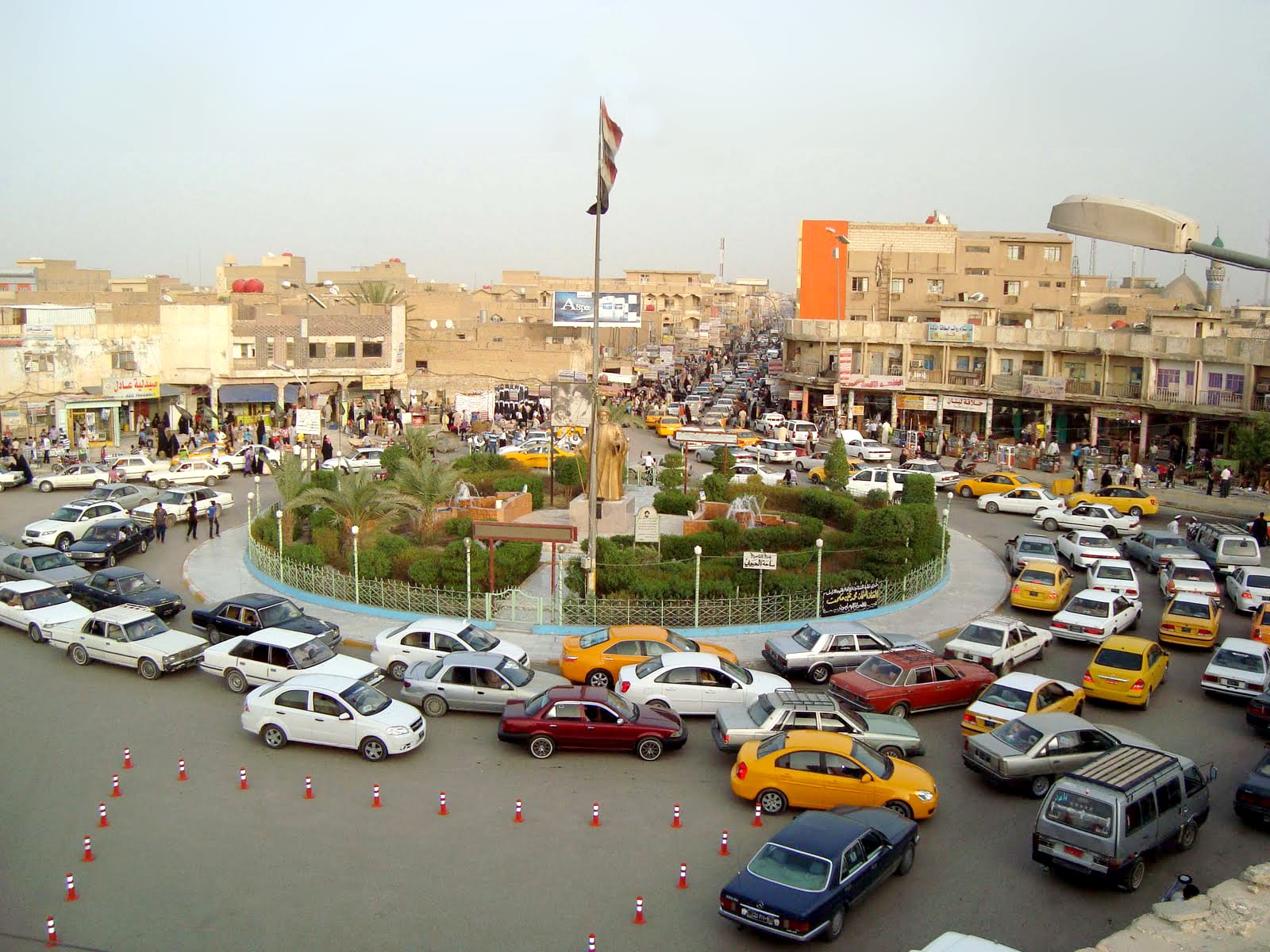
Traffic circling a planted roundabout with a statue and an Iraqi flag, ringed by low shopfronts in the centre of Nasiriyah

Basra & the South, Iraq

Nasiriyah

The central square of Nasiriyah on the lower Euphrates. (Mohamad.bagher.nasery / Wikimedia Commons · CC BY-SA 3.0)

A city on the lower Euphrates in southern Iraq, founded in 1872 by a sheikh of the Muntafiq confederation and now the capital of Dhi Qar province. It stands a short drive from Ur and the Sumerian mounds of the desert plain, and at the western edge of the Mesopotamian marshes. This page is written to explain the city, not to encourage travel.

Neighbourhoods

  • The centre and Habboubi Square
    • First-time visitors
    • Markets
    • Local life

    The commercial heart of the city, built around the square named after the poet Muhammad Said al-Habboubi, whose statue was raised at its centre in 1971. Shops, money changers, tea stalls and shared-taxi ranks crowd the streets around it, and the square has been the gathering point for the city's protests.

    Open in Maps
  • The Euphrates banks
    • Walks
    • Evenings
    • Riverside food

    The river cuts through the middle of the city and is crossed by several bridges. Paved riverside stretches with lamps and benches fill with families after sunset, and fish grills and cafés work along the water on warm evenings.

    Open in Maps
  • The old souq quarter
    • Markets
    • Historic district

    The lanes of small traders behind the main street, where cloth, spices, household goods, sweets and dates are sold from narrow shopfronts. It is the busiest part of the city in the morning and closes through the worst of the afternoon heat.

    Open in Maps
  • The western outskirts towards Ur
    • Close to the ruins
    • Quiet and residential

    Newer housing, workshops and the highway spread west of the centre towards the airbase and the desert plain where the ziggurat of Ur stands. There is little to see here, but almost every visit to the ancient city passes through it.

    Open in Maps

Things to do

Ur and the Sumerian cities

  • Ziggurat of Urlandmark

    The best-preserved ziggurat in Iraq, built around 2100 BC under Ur-Nammu for the moon god Nanna and partly reconstructed in the 20th century.

    Open in Maps
  • Urlandmark

    The Sumerian city beside the ziggurat, with excavated houses, temples and a building linked by tradition to Abraham; Pope Francis visited the site in March 2021.

    Open in Maps
  • Royal Cemetery at Urattraction

    The burial ground excavated by Leonard Woolley in the 1920s, which produced the gold headdresses, lyres and the Standard of Ur now in museums abroad.

    Open in Maps
  • Tell al-'Ubaidlandmark

    A small mound about seven kilometres west of Ur that gave its name to the Ubaid period, the culture that preceded Sumer in southern Mesopotamia.

    Open in Maps
  • Eridulandmark

    A low mound in the desert south-west of Ur, held in Sumerian tradition to be the first city of all, with the remains of a ziggurat and temples.

    Open in Maps

Sumerian cities further out

  • Girsulandmark

    The mound of Tello north of the city, capital of the Sumerian state of Lagash and the site of the first great excavations of Sumerian material in the 19th century.

    Open in Maps
  • Larsalandmark

    The ruins of a city that ruled southern Mesopotamia in the early second millennium BC, with the remains of the temple of the sun god Utu.

    Open in Maps
  • Lagashlandmark

    A large low tell on the plain north-east of Nasiriyah, one of the main cities of the Sumerian world, dug in several campaigns since the 19th century.

    Open in Maps

The marshes and river towns

  • Central Marshespark

    The reed beds and lagoons east of the city, drained in the 1990s and partly reflooded after 2003, and part of a UNESCO World Heritage Site.

    Open in Maps
  • Al-Chibayishneighborhood

    The marsh town on the Euphrates from which most boat trips into the wetlands set out, about an hour and a half east by road.

    Open in Maps
  • Suq al-Shuyukhneighborhood

    An old trading town south-east of Nasiriyah, on the right bank of the Euphrates at the western end of the Hammar lake, long a market for the tribes of the marshes and the desert.

    Open in Maps

Seasonal events

  • Muharram and Ashurathe first month of the Islamic year, which moves through the seasons

    Black banners, processions and public meals mark the mourning for Husayn ibn Ali, observed intensely across the Shia south.

  • Arba'eenforty days after Ashura

    Millions walk to Karbala, and towns along the southern roads set up free kitchens and rest stations for the walkers.

  • Date harvestlate summer into autumn

    Dates come off the palms along the Euphrates and fill the markets, fresh and dried, and are pressed into syrup.

Eat and drink

Long-standing places and food districts in Nasiriyah. Hours, ratings and directions come from your maps app, always current.

Nasiriyah classics

  • Masgouf grills by the riverrestaurant

    Carp split open and stood on stakes around an open wood fire, then finished over the embers with tomato and onion — the standard river meal along the Euphrates bank.

    Open in Maps
  • Quzi and rice kitchensrestaurant

    Lunch counters in the centre serving slow-cooked lamb on saffron-tinted rice, kubba, stews thickened with okra or beans, and flatbread from clay ovens.

    Open in Maps

Markets and tea

  • The central marketmarket

    Dates, river fish, bread, sweets, spices and dried black lime sold in the lanes off the main street, busiest in the early morning.

    Open in Maps
  • Teahouses around Habboubi Squarecafe

    Small rooms of benches and glass istikan cups where sweet black tea and cardamom coffee are drunk over conversation, cards and dominoes.

    Open in Maps

Experience Nasiriyah

History

Nasiriyah is a young city in an ancient landscape. It was founded in 1872 by Nasir Pasha al-Sadun, a sheikh of the Muntafiq tribal confederation, who laid out a planned settlement on the Euphrates as a seat for his authority and a market for the tribes; the city carries his name. Ottoman administration followed, and the town grew as a trading point between the marshes, the desert grazing lands and the river route towards Basra.

The plain around it, however, had held cities for five thousand years before that. Ur, about 16 kilometres to the south-west, was a Sumerian capital under Ur-Nammu around 2100 BC; Eridu, Girsu, Larsa and Lagash lie scattered across the same flat ground. Leonard Woolley's excavations at Ur in the 1920s and 1930s, which uncovered the royal graves and their gold and lapis, made the area known far outside Iraq, and the mounds have been dug by foreign and Iraqi teams ever since.

In the 20th century Nasiriyah became the capital of Dhi Qar province and a centre of left-wing and tribal politics. It suffered in the Iran–Iraq War, joined the southern uprising after the 1991 Gulf War and was punished for it, and lost much of its hinterland when the marshes were drained in the 1990s, bringing displaced marsh families into its edges. Heavy fighting took place here during the 2003 invasion. From October 2019 the city was one of the strongest centres of the Tishreen protest movement, with long occupations of its central square over jobs, services and corruption, and it remains a byword in Iraq for protest.

Culture & Customs

Nasiriyah has a reputation within Iraq for poetry, political argument and a stubborn independence of mind. It produced or sheltered writers and communists in the middle of the 20th century, and the shaabi poetry of the south — verse in colloquial Iraqi Arabic, recited and sung — is still composed and performed here. The city's central square honours the poet Muhammad Said al-Habboubi, whose statue was raised there in 1971, and it has served ever since as the city's meeting place and the stage for its politics.

Society is Arab and overwhelmingly Shia, and tribal identity matters: the great confederations of the lower Euphrates, above all the Muntafiq, still shape families, marriages and the settling of disputes, and a sheikh's guesthouse can carry as much weight as a courtroom. The mourning rituals of Muharram dominate the public calendar, with black banners over the streets, processions, recitations and free food, and Arba'een sends walkers north towards Karbala along roads lined with volunteer kitchens.

Hospitality is close to obligatory. Guests are given tea, coffee flavoured with cardamom and whatever food is in the house, and refusing outright can offend. Dress is conservative, greetings are long, and the day is arranged around the heat: business in the morning, rest in the afternoon, and social life after dark, when the square, the riverbanks and the tea rooms fill up.

Daily Life

About 700,000 people live in Nasiriyah, the ninth largest city in Iraq and the administrative centre of Dhi Qar province. Its population grew quickly in the late 20th century as villagers and marsh families moved in, and much of the city is low concrete housing spread out from the older core beside the river.

Work is mostly public: provincial administration, schools, hospitals, the police and the army employ a large share of those with steady jobs, alongside shopkeeping, transport, building work and farming in the irrigated land nearby. The province has oil fields, but they employ relatively few people directly, and the gap between provincial oil revenue and local unemployment is a standing grievance — one of the reasons the city became the centre of the 2019 protests. Many young people look for work in Basra or Baghdad, or abroad.

Daily life turns on water and electricity. Summer temperatures near 50°C make power cuts serious, and generators, some shared by a whole street, run through the afternoon. The Euphrates arrives here after long use upstream, and falling flows, salt and drought have hurt farming and the marshes alike, pushing more marsh families into the city. Mornings begin early in the markets, the middle of the day empties the streets, and the evening belongs to the riverfront, the square and the tea houses.

Food

The Euphrates sets the menu. Masgouf, carp split open and roasted upright beside a wood fire before being laid over the embers, is the dish of the riverbank, eaten with flatbread, raw onion, lemon and amba, a tart mango pickle. Other river fish are fried or stewed, and further towards the marshes the catch includes bunni and other carp-family fish that are the mainstay of marsh households.

Everyday food is southern Iraqi: quzi, lamb cooked until it falls apart and heaped on rice with almonds and raisins; timman bagilla, rice with broad beans and dill; kubba, shells of bulgur or rice stuffed with spiced meat, fried or dropped into soup; dolma, vegetables and vine leaves stuffed and cooked in a sour sauce; and thick stews of okra, white beans or aubergine served over rice. Noomi Basra, dried black lime, gives many of these their sour edge, and bread is baked on the inside wall of a clay tannour oven, often at home.

Dates are the pride of the province, sold fresh at the end of summer and dried the rest of the year, pressed into dibis syrup that is eaten with tahini, and baked into klecha, the stuffed biscuits made for Eid. The marshes supply buffalo milk, which becomes geymar, a thick clotted cream spread on bread with date syrup for breakfast. Tea is drunk very sweet from small waisted istikan glasses at every hour, and cardamom coffee is served to guests.

Planning tools

Budget

Nasiriyah is inexpensive by Iraqi standards. Hotels are basic and aimed at Iraqi travellers, food from local kitchens costs little, and the main expense for a visitor is a car with a driver to reach Ur and the other mounds, or a boat and guide for the marshes. Cash is essential.

Daily Budget Midrange
USD 110–230 (better hotel, private car and driver, marsh boat and guide)
Daily Budget Shoestring
USD 40–70 (simple hotel, local restaurants, shared taxis)

Bring US dollars in cash and change some into dinars; agree the price of a car or a boat trip before setting out.

Best Time to Visit

November to March, when the heat breaks and the marshes are fuller and busy with migrating birds; October and April are warm but manageable. Summer is punishing. Since February 2026 the war between the United States and Israel and Iran and its allies has disrupted flights and travel across the region, so current conditions matter more than the season.

Suggested Number of Days

The city itself is usually seen in a day, often as a base rather than a destination. Two or three days allow the Sumerian mounds on the plain and a boat trip into the marshes as well. Heat, road conditions and checkpoints all slow movement and should be allowed for.

First Visit
1 day
With Surroundings
2–3 days

Transportation

Movement is by road. Highways link Nasiriyah with Basra, Samawah, Diwaniyah and Baghdad, with frequent checkpoints, and shared taxis leave from garages on the edge of the city. Within the city, taxis and small buses cover the main streets. Ur lies a short drive west, the other Sumerian sites are scattered across the plain on rough tracks, and boats are the only way into the marshes.

Hire a car, driver and marsh boatman through a trusted local operator; independent long-distance driving is not advisable.

Airport & Station Connections

Most arrivals are by road from Baghdad, about 360 kilometres to the north-west, or from Basra to the south-east, both several hours by car or shared taxi. Basra and Baghdad have the nearest international airports, and air travel across the region has been disrupted since the war that began in February 2026. A railway line between Baghdad and Basra passes through the province.

Walkability

The centre around Habboubi Square and the riverbanks can be walked, and distances there are short, but pavements are uneven, traffic is heavy and unpredictable, and the summer heat rules out walking for much of the day. The ancient sites are far beyond walking distance and need a vehicle.

Safety

Most Western governments advise against all or all-but-essential travel to this part of Iraq, though visitors do reach Nasiriyah, Ur and the marshes with local operators. Risks include militia and tribal tension, kidnapping risk, and demonstrations, which have often centred on the main square. Unexploded ordnance remains a hazard in parts of the countryside, and extreme heat is a real danger for much of the year.

Follow the current government travel advisories, use a local operator, keep away from border areas and demonstrations, stay on known roads and paths, and carry plenty of water. Check current official travel advice before travelling.

Climate

A desert climate at the edge of the marshes, among the hottest inhabited places on Earth in summer. Rain falls only in winter and is light, and spring and early summer bring dust storms that can close roads and airports.

Summer
extreme heat, regularly 45–50°C by day, with warm nights and dust
Winter
mild, around 12–20°C by day, with cool nights and occasional rain

Local Customs

This is a conservative, overwhelmingly Shia Arab city where tribal ties remain strong. Modest dress is expected of everyone, with shoulders and knees covered; women visiting shrines cover their hair. Greetings are unhurried, hospitality is pressed on guests, and an invitation to tea is difficult to refuse. Alcohol is not part of public life here.

Ask before photographing people, and do not photograph checkpoints, soldiers, police or government buildings. Remove shoes and dress modestly at religious sites, and follow a host's lead on whether to shake hands between men and women.

Common Payment Methods

The currency is the Iraqi dinar, and US dollars are widely held and changed in the markets. This is a cash economy: card payment is rare outside a few hotels, ATMs are unreliable, and visitors bring clean, undamaged dollar notes to change into dinars as they go.