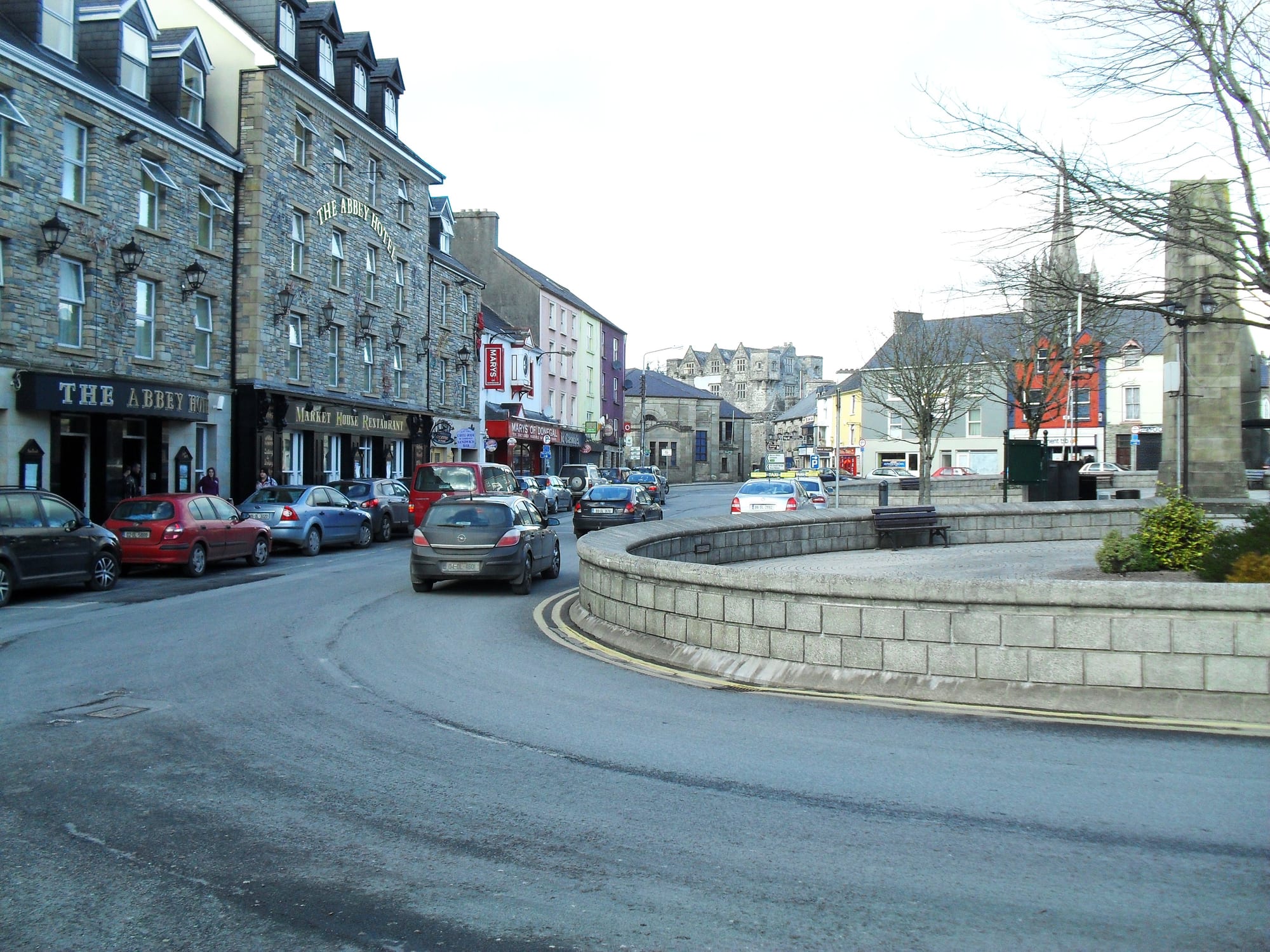
Stone-fronted buildings curving around the Diamond in Donegal, with a low stone wall, an obelisk and a church spire

Galway, Donegal & the Wild Atlantic West, Ireland

Donegal

The west side of the Diamond, the central square of Donegal town. (Dean Molyneaux / Wikimedia Commons · CC BY-SA 2.0)

A small market town where the River Eske meets Donegal Bay, below the Blue Stack Mountains in the south of County Donegal. Once the seat of the O'Donnell lords of Tyrconnell, it was rebuilt around its square, the Diamond, by a Plantation settler after 1607, and is now a base for the bay's beaches, the mountains and the cliffs of Slieve League.

Neighbourhoods

  • The Diamond and Main Street
    • First-time visitors
    • Pubs and music
    • Shops

    The square laid out by Basil Brooke in the early 17th century, with the obelisk to the Four Masters at its centre and the Catholic church at its east end. Pubs, cafés, shops and the main bus stop are on or just off it, and Main Street climbs away uphill.

    Open in Maps
  • Castle Street and the river
    • Historic district
    • Riverside walks

    The streets beside the River Eske around Donegal Castle and the Church of Ireland parish church, a few steps from the Diamond. A riverbank walk follows the west bank of the Eske from the bridge for about three kilometres.

    Open in Maps
  • The Quay and the abbey
    • Waterfront
    • Quiet and residential

    The waterfront where the Eske widens into the bay, with the tourist office, the ruins of Donegal Abbey and its old graveyard on the shore, and boat trips on the bay in summer.

    Open in Maps

Things to do

In the town

  • Donegal Castlelandmark

    The O'Donnells' stronghold on the River Eske, rebuilt with a Jacobean wing by Basil Brooke after 1611 and restored by the Office of Public Works in the 1990s.

    Open in Maps
  • Donegal Abbeylandmark

    The ruins of a Franciscan friary built in 1474 by Hugh Roe O'Donnell and his wife Finola, wrecked during the 1601 siege, with a graveyard above the estuary.

    Open in Maps
  • The Diamondlandmark

    The town's central square, laid out in the early 17th century, with an obelisk honouring the Four Masters, who compiled their great annals of Irish history in 1632–36.

    Open in Maps
  • Donegal Railway Heritage Centremuseum

    A museum in the old station building recalling the two narrow-gauge railways that crossed County Donegal from 1863 until 1959.

    Open in Maps
  • St Patrick's Church of the Four Masterslandmark

    The Catholic church at the end of the Diamond, completed in 1935 to designs by Ralph Henry Byrne in a mix of neo-Irish Romanesque and neo-Gothic.

    Open in Maps

Lakes, mountains and beaches

  • Lough Eskepark

    A lake north-east of the town, linked to it by the River Eske and ringed by the Blue Stack Mountains.

    Open in Maps
  • Blue Stack Mountainstrail

    The main mountain range of south Donegal, rising to 674 metres at Croaghgorm, used by walkers as a base from the town.

    Open in Maps
  • Rossnowlaghbeach

    A seaside village south-west of the town whose long beach on Donegal Bay is known for its surfing.

    Open in Maps

Short trips from the town

  • Mountcharlesattraction

    A village 6 km from the town on the Killybegs road.

    Open in Maps
  • Killybegsattraction

    The fishing town on the north shore of Donegal Bay, home to Ireland's largest trawlers and famous for its hand-knotted Donegal Carpets.

    Open in Maps
  • Lough Derglandmark

    A lake near the border best known for St Patrick's Purgatory, the island site of a penitential pilgrimage.

    Open in Maps
  • Slieve Leagueviewpoint

    A mountain on the Atlantic coast whose sea cliffs, rising to 601 metres, are the second-highest in Ireland and among the highest in Europe, often photographed from the Bunglass viewpoint, reached by a narrow road from Teelin.

    Open in Maps

Eat and drink

Long-standing places and food districts in Donegal. Hours, ratings and directions come from your maps app, always current.

Donegal classics

  • Blueberry Tea Roomscafe

    A café on Castle Street serving snacks and light meals.

    Open in Maps
  • The Forgerestaurant

    A bar on Meetinghouse Street.

    Open in Maps

Pubs and food streets

  • Pubs on the Diamond and Main Streetneighborhood

    The town's pubs cluster around the square and up Main Street, some with traditional music and food.

    Open in Maps
  • Quay Streetneighborhood

    The street down to the waterfront, with seafood restaurants and takeaways a short walk from the Diamond.

    Open in Maps

Experience Donegal

History

Donegal's Irish name, Dún na nGall, means 'fort of the foreigners', and there are traces of ringforts and earthworks around the town from prehistoric times. From the 15th to the early 17th century it was the capital of Tyrconnell, the Gaelic kingdom of the O'Donnells, who built their castle on the River Eske and, in 1474, a Franciscan friary on the shore of the bay. The O'Donnells were among the leaders of resistance to English colonisation, and the abbey was used for a meeting with envoys of Philip II of Spain during the Nine Years' War. In 1601 it was wrecked during the Siege of Donegal.

After the Flight of the Earls in 1607 the Crown seized the castle and granted it, around 1611, to Captain Basil Brooke as part of the Plantation of Ulster. Brooke added a Jacobean wing to the castle and laid out the present town plan around the Diamond. Meanwhile the displaced friars kept their scholarship alive, and in 1632–36 Mícheál Ó Cléirigh and his collaborators compiled the Annals of the Four Masters, commemorated today by the obelisk on the square.

From the late 17th century to the early 20th the town belonged to the estates of the Gore family, later Earls of Arran, and took on its present appearance. It sent two members to the Irish House of Commons until 1801. In 1841 it had 1,366 people; the Famine left a workhouse, now part of the hospital, and famine graves. The railway arrived in 1889 and closed in 1960.

Culture & Customs

The Diamond is the heart of the town, a meeting place for music, poetry and cultural gatherings, and pubs, some with traditional music, stand around it. Donegal is proud of its Gaelic past: the O'Donnells, and above all Red Hugh O'Donnell, whose story inspired many books and films, including Disney's The Fighting Prince of Donegal, and the Four Masters, whose annals are chronicles of medieval Irish history.

Textiles are part of the town's identity. Donegal tweed, woven in the county for centuries from local materials, is with Harris Tweed the most famous tweed in the world, best known as a plain-weave cloth flecked with small pieces of coloured yarn. Like most Irish clothing makers, local firms have shrunk; one tailor who began making suits in 1924 switched to hats in 1964 and now ships them around the world.

Sport is led by Gaelic football, played by the Four Masters GAA club, which is also developing hurling, alongside soccer, rugby, basketball and athletics. The town hosted the final stage of the World Rally Championship in 2009. Faith remains visible, from the Catholic church of the Four Masters to the pilgrimage at Lough Derg near the border.

Daily Life

About 2,700 people lived in Donegal town at the 2022 census. It is neither the county town, which is Lifford, nor the largest town, which is Letterkenny, but it is the market and service centre for the south of the county, with the community hospital, supermarkets and the regional newspapers the Donegal Democrat and Donegal Post. Ocean FM has a studio in the town.

Tourism is a large part of the economy. Visitors use the town as a base for the beaches at Murvagh and Rossnowlagh, the Blue Stack Mountains and the coast to the west, and in 2016 National Geographic Traveller named Donegal the coolest destination of 2017. Traditional clothing manufacture survives on a smaller scale than before.

Life here runs across the border. Without a railway, the town relies on buses and cars, and many routes to Dublin and Belfast pass through Northern Ireland, with no checks at the frontier. A current issue in the county is the defective concrete blocks crisis, which concerns homes built with blocks containing excessive mica.

Food

Donegal's food is that of the north-west coast. Irish cuisine is founded on the crops and animals of a temperate climate and on fish and seafood from the surrounding Atlantic, and chowder is popular around the coasts. Killybegs, on the north shore of the bay, is home to the country's largest trawlers, and seafood features on menus in the town.

The national standards — Irish stew, bacon and cabbage, boxty, colcannon and soda bread, which is predominantly an Ulster bread — belong as much to Donegal as anywhere. Pubs around the Diamond serve food by day, a tea room on Castle Street offers light meals, and the town also has a Bangladeshi restaurant and Chinese and Italian kitchens.

Quay Street leads down to the waterfront, where restaurants serve seafood and takeaways cater for families. Supermarkets, one on the Diamond itself and another south of the centre, supply self-caterers, and the craft village south of the town sells local work.

Planning tools

Budget

Donegal is among the cheaper parts of Ireland, with B&Bs, guesthouses and hotels in and around the town. Rooms fill in July and August. Bus services are limited and there is no bike or car hire in the town, so a car hired elsewhere is the main extra cost for touring the coast.

Daily Budget Midrange
USD 150–280 (B&B or hotel, restaurant dinners, a hire car and paid sights)
Daily Budget Shoestring
USD 70–115 (hostel or budget B&B, pub food and supermarket meals, local buses)

The riverbank walk, the abbey ruins, the Diamond and the beaches cost nothing; the nearest car hire offices are in Letterkenny and Derry.

Best Time to Visit

May to September, for long evenings, boat trips on the bay and the best walking weather in the mountains and on the cliffs. July and August are busiest. Winter is wet, windy and quiet, with short days, though the town stays open as a working market town.

Suggested Number of Days

A day or two covers the town. Allow three or four days to use it as a base for the bay, the mountains and the south-west coast; the weather and the slow roads usually decide how much is possible.

First Visit
1–2 days
With Surroundings
3–4 days

Transportation

The town is small enough to walk, but outlying sights need a car. Bus Éireann and Local Link buses run west to Killybegs and Glencolmcille, north to Ardara, Glenties and Dungloe, and south to Ballyshannon and Rossnowlagh, but services are infrequent. There is no bike or car hire in town; there are local taxis.

Roads in south-west Donegal are narrow and winding, including the narrow road to the Slieve League viewpoint; drive slowly.

Airport & Station Connections

There is no railway: the town's station closed in 1960, and the nearest trains are at Sligo, with services from Dublin, and Derry, with services from Belfast. Buses from Dublin take about three and a half hours via Cavan and Enniskillen, crossing Northern Ireland; express coaches run from Derry in about an hour and a half and continue south to Sligo, Knock and Galway. Many drivers also come through Northern Ireland.

Walkability

The centre is compact: the Diamond, the castle, the quay and the abbey are all a few minutes apart, and the riverbank walk runs for about three kilometres along the Eske. Main Street climbs from the square. Outside town, roads are narrow and often without pavements.

Safety

Ireland is a very safe country, with low levels of violent crime. Around Donegal the hazards are natural: Atlantic surf and rips on exposed beaches, a fast incoming tide at Rossnowlagh, where many people park on the sand, and unfenced cliffs at Slieve League.

Swim only at lifeguarded beaches, check the tide before parking or walking on the sand, and keep back from cliff edges in wind. Check current official travel advice before travelling.

Climate

A mild, wet oceanic climate with small differences between summer and winter and rain spread through the year. Across Donegal Bay in Sligo, the mean yearly temperature is just under 10°C.

Summer
cool and showery — the mean July temperature in Sligo, across the bay, is about 15°C
Winter
mild, wet and windy — the mean January temperature in Sligo, across the bay, is about 5°C

Local Customs

The Diamond is the hub for music, poetry and cultural gatherings, and pub sessions are part of evening life. Gaelic football is the main sport, played by the Four Masters club. Donegal's life runs across the border, and the town is proud of its O'Donnell past and its Four Masters.

Ask before recording a music session, respect graves at the abbey and the famine graveyard, and check that car and travel documents are valid for Northern Ireland if driving through it.

Common Payment Methods

The currency is the euro; Northern Ireland, a short drive away, uses the pound sterling. Cards are accepted in most outlets, and the banks around the Diamond have cash machines.