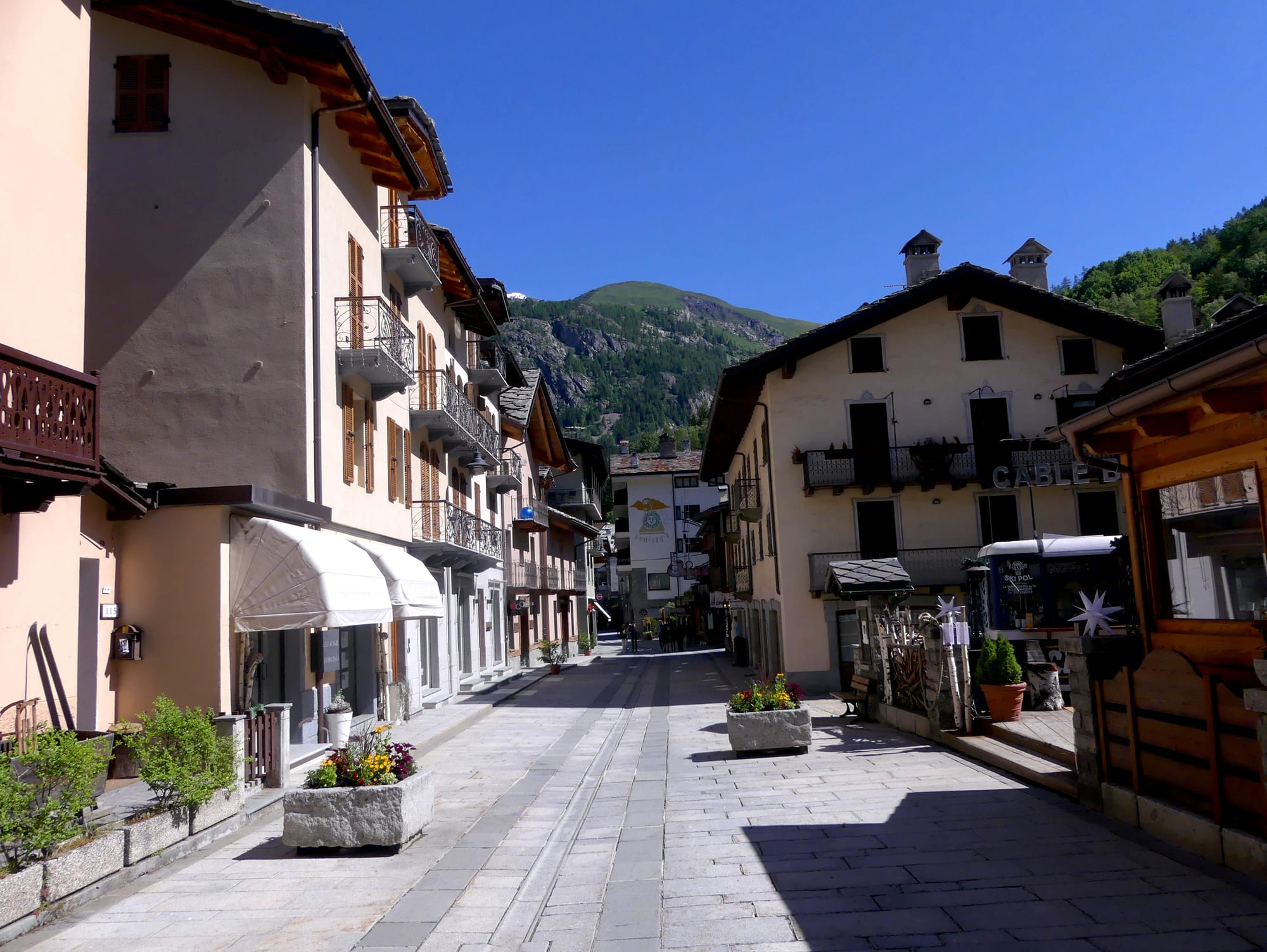
A paved pedestrian street lined with pale balconied houses and flower planters, with a wooded mountain behind under blue sky

Aosta Valley, Italy

Courmayeur

Via Roma, the pedestrian main street of Courmayeur, on a June morning. (Florian Pépellin / Wikimedia Commons · CC BY-SA 4.0)

A mountain town at the head of the Aosta Valley, on the southern side of Mont Blanc, where the Val Ferret and Val Veny meet. Sulphur springs made it a spa in the 17th century and alpinism made it famous in the 19th; today it is a ski and hiking resort with a pedestrian main street, a rotating cable car into the high peaks and the Mont Blanc Tunnel to France.

Neighbourhoods

  • Courmayeur village and Via Roma
    • First-time visitors
    • Best for food
    • Close to public transport

    The core of the town is the pedestrianised Via Roma, about a kilometre long, ending at the town hall, with shops, bars and restaurants in old stone and plastered houses. The guides' museum and the parish church stand on the square at its heart, and the main cable car to the ski slopes leaves from just south-west of the centre.

    Open in Maps
  • Dolonne
    • Skiing
    • Quiet and residential

    A district across the Dora Baltea, joined to the centre by two bridges, made up largely of residential blocks and holiday accommodation. It has its own cable car up to the slopes, the town's ice rink and a few old houses of noble families, one with a carved lintel dated 1610.

    Open in Maps
  • Entrèves and La Palud
    • Mountain views
    • Cable cars

    Two small settlements at about 1,300 metres, just above the town where the Val Veny and Val Ferret branch off. La Palud stands at the mouth of the Val Ferret and Entrèves holds the base station of the Skyway Monte Bianco, with the glaciers of Mont Blanc directly overhead.

    Open in Maps
  • Val Ferret
    • Hiking
    • Cross-country skiing
    • Quiet

    The side valley running north-east from La Palud towards the Swiss border, below the eastern side of the Mont Blanc massif. In summer it is walking country on the Tour du Mont Blanc; the riverside floor of the valley is a protected nature site.

    Open in Maps

Things to do

Mont Blanc by cable car

  • Skyway Monte Biancoattraction

    The cable car opened in 2015 from Entrèves, whose cabins make a full rotation as they climb to the Pavillon station at 2,173 metres and on to Pointe Helbronner at 3,466 metres, with views of Mont Blanc, the Matterhorn and Monte Rosa.

    Open in Maps
  • Vallée Blanche Cable Carattraction

    The small gondolas that cross about 5 kilometres of glacier from Pointe Helbronner to the Aiguille du Midi above Chamonix, passing high over the Mont Blanc massif and the frontier.

    Open in Maps
  • Alpine Botanical Garden Saussureapark

    Europe's highest alpine botanical garden, at 2,173 metres beside the Skyway's middle station, which holds some 900 alpine plant species.

    Open in Maps

In the town

  • Duke of Abruzzi Alpine Guide Museummuseum

    A small museum on the main square documenting the craft of mountain guiding and the exploratory ascents made by Courmayeur's guides, in the town where Italy's first guides' society was founded.

    Open in Maps
  • Notre Dame de Guérison sanctuarylandmark

    A sanctuary of 'Our Lady the Healer' at the foot of Mont Chétif on the Val Veny road towards the Seigne pass, well known both in Italy and abroad.

    Open in Maps
  • Plan Checrouitviewpoint

    A small plateau at about 1,700 metres reached by cable car from the town and from Dolonne, with restaurants and bars, the starting point for all of the resort's skiing and a lookout on clear days.

    Open in Maps

Valleys and glaciers

  • Val Ferrettrail

    The valley that leads up to the Col Ferret on the Swiss border, crossed on foot by the Tour du Mont Blanc.

    Open in Maps
  • Val Venytrail

    The side valley running south-west from Courmayeur along the flank of the Mont Blanc massif to the Seigne Pass and the French border, used by walkers on the Tour du Mont Blanc.

    Open in Maps
  • Brenva Glacierlandmark

    The second-longest glacier in Italy, descending from the southern face of Mont Blanc into the Val Veny close to Entrèves.

    Open in Maps

Short trips from the town

  • Pré-Saint-Didierattraction

    The neighbouring village down the valley, known for its thermal baths, first built as a spa establishment in 1834 and frequented by the House of Savoy for more than 150 years, and for the gorge of the Verney.

    Open in Maps
  • La Thuileattraction

    A mountain village on the road to the Little St Bernard Pass and France, with a ski area that the Courmayeur six-day pass also covers for part of a week.

    Open in Maps
  • Chamonixattraction

    The French resort on the northern side of Mont Blanc, one of the oldest ski resorts in France, reached by bus through the Mont Blanc Tunnel or by the chain of cable cars over the peaks.

    Open in Maps

Seasonal events

  • Ultra-Trail du Mont-Blanc weeklate August

    The week of mountain ultramarathons around Mont Blanc; the main race passes through the town, and the shorter CCC race to Champex and Chamonix starts in Courmayeur.

  • Tor des GéantsSeptember

    An endurance trail race of 330 kilometres around the high paths of the Aosta Valley, run since 2010 within a 150-hour limit, starting and finishing on the town's main square.

Eat and drink

Long-standing places and food districts in Courmayeur. Hours, ratings and directions come from your maps app, always current.

Courmayeur classics

  • Restaurants on Via Romaneighborhood

    The pedestrian main street and the lanes just off it hold most of the town's restaurants, serving Valdostan mountain dishes built around fontina, cured meats and polenta.

    Open in Maps
  • Plan Checrouit mountain restaurantsrestaurant

    Restaurants and bars on the plateau above the town, reached by cable car, which serve skiers by day and stay open into the evening.

    Open in Maps

Cafés and bars

  • Aperitivo bars on Via Romacafe

    Many bars along the main street serve an aperitivo with free snacks in the late afternoon, a good moment to try the local white Blanc de Morgex et de La Salle.

    Open in Maps

Experience Courmayeur

History

Courmayeur appears in medieval documents as Curia majori, and the maps of Ortelius in the 16th century marked it as Auri Fodinæ, "gold mines", for the gold found in the Val Ferret; old silver-lead mines in the massif, one known as the Trou des Romains, may go back to Roman times. The village's first fame came in the 17th century from its four sulphurous springs, which made it a spa resort.

In the second half of the 18th century the Genevan naturalist Horace-Bénédict de Saussure explored the massif from here with a guide from Pré-Saint-Didier, looking for a route up Mont Blanc, though the first ascent in 1786 was made from the French side. The 19th-century fashion for alpinism made Courmayeur, with Chamonix and Zermatt, one of the capitals of mountaineering, and Italy's first society of alpine guides was founded here in 1850. Members of the royal family stayed regularly in the 19th century, and in the 20th century the village grew into a ski resort.

Under Fascism its French name was Italianised to Cormaiore, from 1939 until 1946. The Mont Blanc Tunnel to Chamonix opened in 1965, making the town a main gateway between Italy and France; the presidents of the two countries were received at a villa in the town on the day of the opening. In 2014 a referendum to rename the commune Courmayeur-Mont-Blanc failed to reach its quorum, and in 2015 the rotating Skyway Monte Bianco replaced the old cable car to Pointe Helbronner.

Culture & Customs

The mountains are the culture here. The guides' museum on the main square honours the profession that made the town's name, and the town is the start and finish of the Tor des Géants, a 330-kilometre trail race round the Aosta Valley, and the starting point of the CCC race in the Ultra-Trail du Mont-Blanc week. The Giro d'Italia ended a stage here in 1959, the year the town also hosted the Biathlon World Championships, and Courmayeur is the centre of ice hockey in the Aosta Valley, with its rink in Dolonne.

Like the rest of the Valdigne, the upper part of the valley, Courmayeur keeps local traditions: the Badoche folk celebration, led by the group Les Badochys, and palet, a traditional Valdostan game played in the commune. French place names were restored after the Second World War, and the town's name in the local Valdostan patois is Croméyeui. A statue and a botanical park at Plan-Gorret honour the abbé Joseph-Marie Henry, priest, botanist and historian, after whom the main square is also named.

The town's setting has drawn film-makers: scenes of Kingsman: The Golden Circle were shot on the Skyway, and parts of the film Diabolik were shot in the town. Along Via Roma, the early-evening aperitivo is a fixed part of the resort's social life in both seasons.

Daily Life

The commune had 2,494 residents at the end of 2025, spread between the town centre and hamlets such as Dolonne, Entrèves, La Palud, La Saxe and Villair. It is the westernmost commune of the Aosta Valley and the only one in Italy that borders both France and Switzerland. Mont Blanc, the highest mountain in Italy, lies partly within the commune, which shares it with Saint-Gervais-les-Bains and Chamonix in France.

Tourism is the economy, in winter and summer, and the population swells far beyond its resident number in the ski season and in July and August; between the seasons the town is quiet and many businesses close. The tunnel brings a steady stream of heavy traffic up the valley to France.

The mountain itself is a constant presence in local life. The Mont de La Saxe landslide above the hamlet of La Saxe is watched closely by geologists after its movement accelerated, and the Fondazione Montagna Sicura, based at Villard de la Palud, carries out research on mountain safety, climate change, glaciers and snow.

Food

Courmayeur eats in the Alpine style of the Aosta Valley, with butter, cheese and cured meat in place of olive oil. The central ingredient is fontina, a cow's-milk cheese made in the valley since the 12th century; the Aosta Valley version has a protected designation of origin and must be made from unpasteurised milk from a single milking. It is the basis of fonduta alla valdostana, fontina whipped with milk, eggs and truffles, and mature fontina, though hard, still melts well.

Motsetta, or mocetta, is a dried cold cut made across the valley from lean cuts of meat flavoured with garlic, bay leaf, rosemary, sage and other mountain herbs, then salted. The local wine is Blanc de Morgex et de La Salle, a white made from the Prié blanc grape just down the valley, where vineyards at up to 1,200 metres are the highest in Europe and, untouched by phylloxera, still grow on ungrafted rootstock. After a meal comes génépy, a herbal liqueur made by steeping the flowering tops of Alpine wormwood in alcohol, traditionally taken neat.

Most restaurants line Via Roma and its side streets, and more stand up the mountain at Plan Checrouit, serving skiers at lunch and staying open in the evening. Many bars on the main street lay out snacks with drinks at aperitivo time.

Planning tools

Budget

Courmayeur is one of the more expensive places in the Aosta Valley, especially in the ski season, when lift passes and accommodation make up most of the bill and hotels may be booked out by package tours. The Skyway is a significant extra unless a lift pass covers it. Prices are lower between the winter and summer seasons, and staying in Aosta and coming up by bus is a cheaper option.

Daily Budget Midrange
USD 190–380 (mountain hotel, restaurant dinners, cable cars or a ski pass)
Daily Budget Shoestring
USD 90–140 (simple apartment or guesthouse, picnic lunches, aperitivo snacks, local buses, hiking)

Avoid the Italian school half-term in late February, the busiest week of the ski season; the Skyway is routinely closed in November for maintenance.

Best Time to Visit

December to April for skiing, when the resort's height makes snow reliable; late June to mid-September for walking in the Val Ferret and Val Veny and for the high cable cars, with July and August the busiest months. Spring and late autumn are quiet, with many lifts closed.

Suggested Number of Days

Two or three days cover the town and the high cable cars, with a spare day for cloud, which often hides the summit. Skiers and walkers usually stay a week, and longer stays can take in the neighbouring valleys and the French side of the mountain.

First Visit
2–3 days
With Surroundings
5–7 days

Transportation

The town centre is small and walkable. Local buses circle the town as far as La Palud about every half hour, and the cable cars from the centre and from Dolonne lift skiers to Plan Checrouit. The ski area does not link to any other, so reaching La Thuile or Pila means a bus or a car.

Winter tyres or snow chains are compulsory on many mountain roads in winter; the high passes close with snow.

Airport & Station Connections

Geneva Airport is the closest, about 100 kilometres away through the Mont Blanc Tunnel; Turin Airport is about 150 kilometres south and Milan's airports more than 220 kilometres away. Trains run from Turin to Aosta, changing at Ivrea, and buses connect Aosta and Courmayeur in about an hour. Buses also run to Chamonix through the tunnel in about 45 minutes. Drivers arrive on the A5 motorway from Turin and Aosta.

Walkability

The centre is compact and Via Roma is traffic-free, so most of the town can be crossed on foot in a few minutes, though the streets climb and can be icy in winter. Dolonne is a short walk over the river; Entrèves, La Palud and the Skyway are a few kilometres up the valley and easier by bus. Marked paths lead from the town into the side valleys.

Safety

Italy is generally safe, with low levels of violent crime against visitors. In Courmayeur crime is rarely a concern; the risks are mountain ones — sudden changes of weather, altitude on the high cable cars, crevasses on the glaciers, and avalanches off the marked pistes, where fatal accidents are not uncommon.

Hire a mountain guide for glacier routes and off-piste descents from Pointe Helbronner, check avalanche bulletins before leaving the pistes, and carry warm clothing for the high stations even in summer. Check current official travel advice before travelling.

Climate

An Alpine climate, with short, cool summers and harsh, snowy winters. The town lies at about 1,224 metres, so it is far cooler than the floor of the valley below, and the summits above it carry permanent glaciers.

Summer
short and cool in the town, with afternoon thunderstorms; on the valley floor in nearby Aosta, June and July mornings are around 15°C and afternoon highs commonly reach 32–33°C
Winter
harsh and snowy, with reliable snow on the slopes; even in nearby Aosta, lower down, February nights often stay below 0°C, and the record low there is −18°C

Local Customs

The town is bilingual: Italian is the everyday language, French is co-official, and place names, including Courmayeur itself, are French. Tips are not customary in Italy but are given for special service; restaurants usually add a cover charge, the coperto, which is not a tip, and tips cannot be added to a card bill. The aperitivo, a drink with snacks before dinner, is part of the evening routine.

Churches are places of worship, so keep quiet during services; respect closed paths and private pastures in summer, and leave gates as found.

Common Payment Methods

The currency is the euro. Cards work widely in shops, restaurants and at the lift offices; keep a little cash for small bars, mountain huts and tips. A per-night tourist tax may be collected by accommodation.