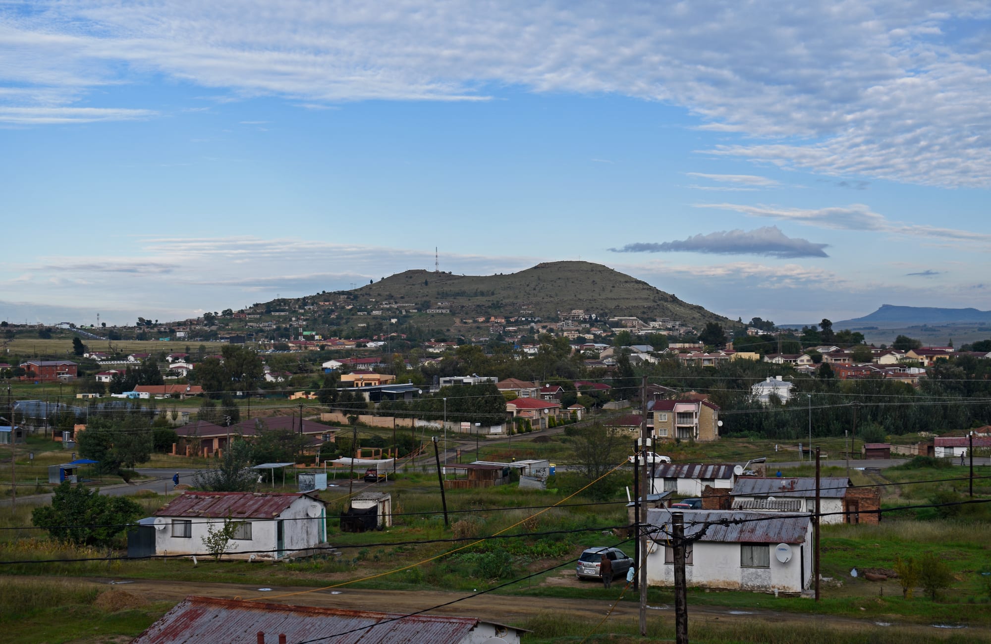
Low houses with tin roofs spread across a green valley below a long flat-topped hill under a blue sky in Maseru

Lesotho

Maseru

The Lower Thetsane area of Maseru spreads below a flat-topped hill on the city's southern edge. (Ymblanter / Wikimedia Commons · CC BY-SA 4.0)

Lesotho's capital and only large city, on the Mohokare (Caledon) River where the lowlands meet the South African border. Founded as a British police camp in 1869, with a Sesotho name meaning red sandstones, it is a low-rise administrative and trading town of about 330,000 people, with craft shops, garment factories and the roads that climb into the mountains.

Neighbourhoods

  • Kingsway and the city centre
    • First-time visitors
    • Shops and crafts
    • Close to public transport

    Kingsway, the first paved road in Lesotho, runs through the centre past government offices, banks, churches and craft shops towards the Royal Palace. Almost everything official happens along it, and the minibus taxi ranks that serve the rest of the country are a short walk away.

    Open in Maps
  • Maseru West
    • Quiet and residential
    • Restaurants
    • Embassies

    The leafy district immediately west and north of the centre, with embassies, aid offices, guesthouses and most of the city's sit-down restaurants behind walls and hedges. It is the calmest part of the city and an easy walk or short drive from Kingsway.

    Open in Maps
  • Thetsane
    • Local life
    • Shopping

    The industrial south of the city, where most of Lesotho's garment factories stand, surrounded by dense housing and shopping centres. It is where a large share of Maseru works rather than a place visitors linger, and the ridges behind it give long views back over the town.

    Open in Maps
  • Old Europa and the ridges
    • Quiet and residential
    • Views

    An older residential quarter on the higher ground east of the centre, with houses and gardens. The sandstone ridges above it give views over the city and the river plain.

    Open in Maps

Things to do

In the city

  • Basotho Hat craft centreattraction

    A landmark craft shop built in the shape of the mokorotlo, the conical Basotho straw hat, opened in 1962, burned in the unrest of 1998 and rebuilt in 2000, selling Basotho hats, masks, pottery and wood crafts.

    Open in Maps
  • Maseru Bridgetransit hub

    The crossing over the Mohokare (Caledon) River on the city's western edge, the border post between Maseru and South Africa, where the road leads on to Ladybrand and Bloemfontein.

    Open in Maps
  • Setsoto Stadiumattraction

    The national stadium in the city, used mostly for football; FIFA barred it from international matches in 2021, and it staged its first top-flight league match in many years in March 2026.

    Open in Maps

Heritage sites near the city

  • Thaba Bosiulandmark

    The flat-topped sandstone mountain about 24 km east where Moshoeshoe I established his stronghold in 1824 and founded the Basotho nation; a cultural village and visitor centre stand at its foot.

    Open in Maps
  • Kome Caveslandmark

    Mud-walled dwellings built under a sandstone overhang about 35 km from the city and still lived in by descendants of the families who took shelter there in the nineteenth century.

    Open in Maps
  • Ha Baroanaattraction

    A rock-art site near Nazareth village east of Maseru, with San paintings of people and animals thought to be about 2,000 years old.

    Open in Maps

Short trips from the city

  • Romaattraction

    A valley town about 35 km south-east ringed by sandstone cliffs, grown up around a Catholic mission founded in the 1860s.

    Open in Maps
  • National University of Lesothoattraction

    The country's main university at Roma, begun as a Catholic college in 1945 and made a national university in 1975.

    Open in Maps
  • Morijaattraction

    A mission village about 45 km south by road, the site of the first French Protestant mission in Lesotho, founded in 1833; its museum and archives, opened in 1956, keep records of the country's history going back to 1826.

    Open in Maps
  • Mohale Damlandmark

    A rockfill dam about 100 km east on the Senqunyane River, part of the Lesotho Highlands Water Project, reached by a mountain road with wide views.

    Open in Maps

Seasonal events

  • Moshoeshoe's DayMarch

    A public holiday on 11 March, the anniversary of the death of Moshoeshoe I, founder of the Basotho nation, marked with ceremonies and traditional dress.

  • Independence DayOctober

    Parades and official celebrations in the capital on 4 October, the anniversary of independence from Britain in 1966.

  • Morija Arts and Cultural FestivalOctober

    An annual festival begun in 1999 in the mission village south of the capital, with choirs, jazz, traditional music and famo, drama, poetry and traditional dance.

Eat and drink

Long-standing places and food districts in Maseru. Hours, ratings and directions come from your maps app, always current.

Maseru classics

  • Kingsway cafés and takeawaysneighborhood

    The main street is lined with bakeries, takeaways and counters serving papa with stewed beef or chicken and moroho, the everyday lunch of the city.

    Open in Maps
  • Roadside grills near the taxi ranksmarket

    Braai stands around the minibus ranks grill beef, mutton and boerewors over drums of coals and serve it with papa and chakalaka relish.

    Open in Maps

Food districts

  • Maseru West restaurantsneighborhood

    The embassy quarter holds most of the city's sit-down dining, from South African chain restaurants to Chinese, Indian and Italian kitchens.

    Open in Maps
  • Maseru produce marketsmarket

    Open-air stalls in the centre sell maize meal, beans, pumpkin, wild greens and seasonal fruit, alongside vendors selling roasted maize and fat cakes.

    Open in Maps

Experience Maseru

History

Maseru began in 1869, after Basutoland became a British protectorate, when the British set up a police camp on the flat ground beside the Mohokare, the river the colonists called the Caledon. The name is a Sesotho word meaning red sandstones. It was deliberately small: the administration wanted a post on the border rather than a rival to Moshoeshoe I's mountain capital at Thaba Bosiu, 24 km to the east.

Many of its buildings were burned during the Gun War of 1880–81, when the Basotho resisted an attempt by the Cape Colony to disarm them, and was rebuilt after Britain resumed direct control of the territory in 1884. For the next eighty years it stayed a sleepy administrative village of sandstone offices, a few trading stores and mission buildings, while the Basotho population lived in the villages around it. Independence in 1966 made it a national capital, and the town grew quickly, with ministries, a stadium, an airport to the south-east and, later, garment factories on its southern edge.

The city has been marked repeatedly by the politics of the region and of the kingdom. In the apartheid decades Lesotho's support for the ANC brought pressure from South Africa, which at one point virtually closed the land borders. After disputed elections in 1998 and the South African and regional military intervention that followed, riots and looting damaged much of the city, which was rebuilt over the following decade, and the capital has seen further periods of political tension since.

Culture & Customs

Maseru is where Basotho tradition and South African urban culture meet. The Basotho blanket is worn in the street as ordinary clothing, particularly by older men and by people in from the districts, and the mokorotlo, the conical straw hat on the national flag, is sold in the craft shops on Kingsway and gave the best-known building in the city its shape. Wool and mohair weaving, tapestry workshops and pottery are the crafts the capital is known for, several of them begun as mission or cooperative projects.

Music runs from church choirs and the massed choral singing that Lesotho takes seriously, through famo — accordion-led songs with sung poetry that grew up among Basotho migrant workers in South Africa's mines — to South African house and hip hop in the bars. Football is the sport of the city, played on every patch of open ground and watched at Setsoto Stadium, and horsemanship carries prestige: a good pony is still a mark of standing.

Manners are formal and unhurried. People greet before they ask a question, elders and chiefs are addressed with care, and Sesotho is used almost everywhere, with English reserved for offices, schools and business. Sunday belongs to the churches, whose congregations fill the streets in the morning, and the national days — Moshoeshoe's Day in March and independence in October — bring traditional dress, horses and singing into the capital.

Daily Life

About 330,000 people lived in Maseru at the 2016 census, making it by far the largest place in a country of about 2.3 million and the destination for a steady movement of people out of the mountains. The city spreads from the border eastward along Kingsway and up into the hills, with walled suburbs and embassies to the west and north, dense unplanned neighbourhoods on the slopes, and industry in the south.

Work is government, trade and clothing. The ministries and the aid and diplomatic offices employ the professional class; the garment factories in the industrial zones employ tens of thousands, mostly women, producing for export, a trade that was badly shaken in 2025 when the United States imposed a 50 per cent tariff on Lesotho before reducing it to 15 per cent that August. Many other households live on informal trade, on remittances from relatives working in South Africa, or on farming plots outside the city.

The rhythm of the day starts early, with minibus taxis filling before dawn and the border post busy with commuters and shoppers crossing to Ladybrand and Bloemfontein. Water and electricity supply, unemployment among young people and the cost of food are the persistent concerns. Maseru is also the medical centre of the country, and the national response to one of the world's highest rates of HIV is run from here.

Food

Maseru eats what the rest of Lesotho eats, with more choice. Papa, the stiff maize porridge also called pap, is the base of nearly every meal, served with moroho — cooked greens, wild or cultivated — and a stew of beef, mutton or chicken, or with beans. Likhobe, a stew of beans and sorghum, and motoho, a fermented sorghum porridge, are the older dishes that town kitchens still make.

Street and takeaway food is Southern African. Grills around the taxi ranks sell beef, mutton and boerewors sausage cooked over coals with papa and chakalaka, the spiced vegetable relish; vendors sell fat cakes, deep-fried dough buns, and roasted maize cobs in season. Oxtail stew, curries and kebabs are common too, with beetroot and carrot salads as side dishes.

Restaurants are concentrated in Maseru West and the larger hotels, where South African steakhouse and chain cooking sits beside Chinese and Indian kitchens. To drink, there is commercial lager, strong sweet tea in winter, and home-brewed sorghum beer served at gatherings.

Planning tools

Budget

Maseru is inexpensive by regional standards, though it is the most expensive place in Lesotho to sleep and eat. Prices track South Africa's because the currencies are linked. Guesthouses in Maseru West and a few larger hotels near the centre cover most of the range; hiring a vehicle or a driver for trips into the hills is usually the biggest single cost.

Daily Budget Midrange
USD 70–140 (guesthouse or hotel, restaurant meals, a hired 4x4 or a driver for day trips)
Daily Budget Shoestring
USD 30–50 (backpacker lodge or basic guesthouse, self-catering and takeaways, minibus taxis)

Rand and maloti are interchangeable in Lesotho, but maloti are hard to spend in South Africa, so change or use them before leaving.

Best Time to Visit

March to May and September to November bring mild, mostly dry days and clear air for trips into the hills. Summer, from November to March, is warm and green but brings heavy afternoon thunderstorms that can wash out dirt roads. Winter is cold and bright, with hard frosts at night and snow on the high ground east of the city.

Suggested Number of Days

A day or two covers the capital itself, which is small and quickly seen. Three or four allow the heritage sites and mission villages within an hour or two of the city. Anyone continuing into the highlands generally uses Maseru as a start and finish rather than a base.

First Visit
1–2 days
With Surroundings
3–4 days

Transportation

Minibus taxis and shared four-plus-one cars run set routes across the city and out to the districts from ranks near the centre, cheaply and without timetables. Many visitors drive, and a high-clearance or four-wheel-drive vehicle is needed for anything beyond the main tarred roads.

Driving is on the left; roads outside the centre are unlit at night and shared with livestock and pedestrians.

Airport & Station Connections

Most people arrive overland from South Africa through the Maseru Bridge border post over the Mohokare, on the road from Ladybrand and Bloemfontein. Johannesburg is roughly four hours' drive and Bloemfontein about two. Moshoeshoe I International Airport lies about 18 km south-east of the city and has only limited scheduled flights.

Walkability

The centre is walkable in an hour: Kingsway runs a few kilometres through the centre, with the ministries, banks and craft shops along it. Pavements are uneven and often absent outside that strip, the suburbs sprawl over hills, and walking after dark is not advised, so most trips beyond the centre are made by taxi or car.

Safety

Maseru has significant crime by the standards of the country around it, including muggings, carjacking and house break-ins, and political instability has occasionally brought unrest to the capital. The centre is busy and ordinary in daylight, and most visits pass without trouble.

Rural Lesotho and the pony-trekking and lodge circuit are fairly safe, but Maseru has significant crime — muggings, carjacking, and home invasion — so take normal urban precautions and avoid walking after dark. Keep valuables out of sight in vehicles, use a taxi at night, and follow local advice during demonstrations. Check current official travel advice before travelling.

Climate

Maseru sits at roughly 1,600 metres in the lowland belt, which gives it warm summers, cold nights and a dry, sunny winter. Almost all the rain falls between October and April, often as short, violent thunderstorms in the late afternoon. Summer here runs from December to February and winter from June to August.

Summer
warm to hot — December to February days usually in the high 20s °C, with heavy afternoon storms and hail
Winter
cold and clear — June to August days around 15 °C, nights frequently below freezing, with frost and occasional light snow

Local Customs

Greetings matter: 'lumela' with a handshake, and a few words of Sesotho are welcomed. Dress is modest and neat, particularly in government offices and churches, and Sunday is quiet as much of the city attends services. The Basotho blanket is everyday clothing rather than costume, and chiefs and elders are treated with formal respect.

Tipping is not obligatory but around 10 per cent is usual in restaurants; ask before photographing people, herders or ceremonies, and avoid photographing the border post, military and government buildings.

Common Payment Methods

The currency is the Lesotho loti (plural maloti), fixed one-to-one with the South African rand, which circulates freely and is accepted everywhere. Cards work in hotels, supermarkets and larger shops in Maseru, and ATMs are common in the centre, but cash is needed for taxis, markets and anything outside the city.