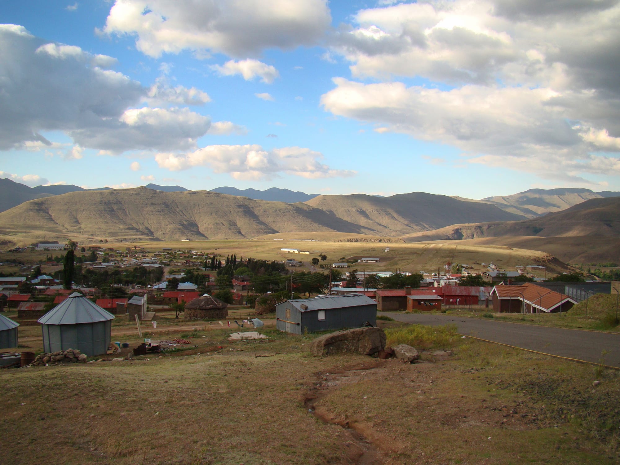
A small town of tin-roofed houses spread across a broad brown valley below rounded mountains under a cloudy blue sky

Lesotho

Mokhotlong

Mokhotlong seen from the high ground south of the town, looking down over the centre and the airstrip. (Bjørn Christian Tørrissen / Wikimedia Commons · CC BY-SA 3.0)

The main town of the eastern highlands of Lesotho, high in the Maloti mountains near the source of the Senqu river. Founded as a remote police post in 1905 and long supplied by pony trek over the Sani Pass, it is the only town in Mokhotlong District, known for blanketed horsemen, hard winters and the roads to the Sani Pass and the high peaks.

Neighbourhoods

  • The main street and town centre
    • First-time visitors
    • Shops and supplies
    • Local life

    A single tarred road through the town lined with stores, bars, a bank, government offices and the taxi rank, busiest when herders ride in from the valleys to trade. Almost every service in the district is on or just off it.

    Open in Maps
  • The upper town
    • Quiet and residential
    • Views

    Housing, the hospital, schools and district offices spread up the slopes south of the centre, with long views across the valley to the airstrip and the mountains beyond. It is a short but steep walk from the shops.

    Open in Maps
  • The river flats and outlying villages
    • Village life
    • Walks

    Below the town the Senqu river runs through grazing land, with stone-and-thatch homesteads, kraals and vegetable plots scattered along it. Paths and rough tracks lead from here into the side valleys and up to the summer cattle posts.

    Open in Maps

Things to do

In and around the town

  • Mokhotlong Airporttransit hub

    The airstrip on the valley floor below the town, built in the years after 1947, around the time the first road linked the district to the rest of the country.

    Open in Maps
  • Upper Senqu riverviewpoint

    The Senqu, known downstream in South Africa as the Orange, rises in the mountains near the town and runs past it as a clear highland stream among grazing land.

    Open in Maps

Peaks and passes

  • Thabana Ntlenyanalandmark

    At 3,482 metres the highest mountain in southern Africa, a summit of tussock grass and low shrubs on the Mohlesi ridge north of the Sani Pass, often climbed from the top of the pass.

    Open in Maps
  • Sani Passlandmark

    A steep gravel road climbing the Drakensberg escarpment from South Africa to the border at the summit, about 2,876 metres up; South Africa generally allows only four-wheel-drive vehicles on it.

    Open in Maps

Short trips from the town

  • Letšeng diamond mineattraction

    At about 3,100 metres the highest diamond mine in the world, known for exceptionally large stones and the highest value per carat of any diamond mine, and open to tours.

    Open in Maps
  • Moteng Passviewpoint

    A steep tarred pass reaching 2,820 metres on the road between Butha-Buthe and Mokhotlong, frequently closed by heavy snow and dangerous with ice in winter.

    Open in Maps
  • Afriskiattraction

    A small ski and mountain resort high on the Maluti range, open for snow sports in winter and for walking and mountain biking in summer.

    Open in Maps
  • Butha-Butheattraction

    The lowland town at the western end of the mountain road, below the hill where Moshoeshoe I first gathered his followers before moving to Thaba Bosiu.

    Open in Maps

Eat and drink

Long-standing places and food districts in Mokhotlong. Hours, ratings and directions come from your maps app, always current.

Mokhotlong classics

  • Main street cook shopsrestaurant

    Small kitchens and takeaways along the main road serve papa with mutton or beef stew and moroho, and fry fat cakes through the morning.

    Open in Maps
  • Mokhotlong general storesmarket

    Traders' stores stocking maize meal, samp, beans, sugar, tea, tinned goods and paraffin, alongside blankets, gumboots and horse tack.

    Open in Maps
  • Roadside grills and stallsmarket

    Stalls near the taxi rank grill meat over coals and sell boiled maize, fruit and vegetables brought up from the lowlands by truck.

    Open in Maps

Experience Mokhotlong

History

Mokhotlong was established in 1905 as a police post in the remote eastern highlands of Basutoland. Its Sesotho name means "place of the bald ibis", after the southern bald ibis, a bird of the Lesotho highlands that breeds on cliffs. The police post was what first brought people to settle in this part of the country, and it grew into a trading centre for the highland villages, although its separation from the rest of the country long held back any larger development.

For decades the post was supplied by pack animal. In 1922 the Basutoland government built a narrow track up the escarpment from Natal, usable only by pack animals, that later became the Sani Pass road, and supplies still came up it by pony trek long after other links improved. Radio contact with Maseru came only in 1947, and in the following years an airstrip was built and a road was laid through the town to link it to the rest of the country.

Roads changed it late. From 1949 a transport business ran jeeps over the Sani Pass, and the tarred road west over the Moteng Pass to Butha-Buthe later tied the district more firmly to the rest of the country. Since then the Letšeng diamond mine, the world's highest, the construction of the Polihali Dam for the second phase of the Lesotho Highlands Water Project and a slow trade in mountain tourism have reshaped a town that still measures much of its life in riding hours.

Culture & Customs

Few places show highland Basotho life as plainly. Men ride into town wrapped in patterned wool blankets pinned at the shoulder, wearing balaclavas and gumboots against the cold, and the horse is transport, tool and status at once; a good mount is discussed as carefully as a herd. Straw hats, saddle blankets and horse tack are made and mended in the district.

The year is organised around livestock. Sheep and goats are taken to high cattle posts in the summer months by boys and young men who live there in stone shelters, and brought down before the snow; the shearing of wool and mohair is one of the district's main sources of cash. Initiation schools are held in the mountains and treated as private, and the authority of chiefs in land, grazing and disputes remains real.

Christianity, mostly Catholic and Protestant, sits alongside older practice, and Sunday services are the week's main gathering. Music is choral singing, the herder's lesiba mouth-bow and famo accordion songs in the bars along the main street. Because the district borders KwaZulu-Natal and the Free State, South African clothing, music and slang arrive with returning migrants, but Sesotho and the blanket remain the everyday markers of belonging.

Daily Life

Mokhotlong is the only town in a district of about 98,000 people (2006 census), most of them scattered through valleys that in places are still several hours from a road. The town is where they come for the hospital, the high school, the magistrate, the bank, the agricultural office and the shops, and where the minibuses and trucks leave for Butha-Buthe and Maseru.

Livestock is the foundation of the economy: wool and mohair sold through shearing sheds, cattle as savings and status, and small plots of maize, sorghum, wheat and peas where the short growing season allows. Government service is the main formal employment in the town itself, alongside the Letšeng diamond mine and the Polihali Dam works in the district, and many households rely on money sent home from South Africa or from the lowlands.

Life is governed by cold and distance. Wood is scarce at this altitude, so dung, paraffin and gas are burned for heat; water is often fetched; power and mobile signal reach the town and thin out beyond it. Winter can close the passes and cut supplies, and the summer storms wash out tracks. Erosion of the grazing land, unemployment among young people and the health services stretched across a wide district are the persistent concerns.

Food

Food here is what the mountains produce and what the trucks bring up. Papa, stiff maize porridge, is the foundation of nearly every meal, eaten with moroho — cooked greens — and with beans, or with a stew of mutton or beef when there is meat. Motoho, thin soured sorghum porridge, is drunk at breakfast, and likhobe, samp and beans cooked slowly together, is the winter standby.

Sheep country means mutton: a slaughter marks a feast, a funeral or the return of a relative, and the meat is shared, grilled over coals or boiled with little more than salt, with the offal eaten the same day. Bread is baked in a three-legged pot under coals, and pumpkin, wild spinach, peas and dried maize are stored against the cold months. The stores on the main street sell maize meal, samp, sugar, tea, tinned fish and bread flour, and vegetables and fruit arrive by truck rather than growing locally.

Drinking is tea, strong and sweet, at almost any hour, and joala, the home-brewed sorghum beer served at gatherings and rituals. Bottled lager comes up the mountain road to the bars along the main street, which fill on shearing days and at month end when wages and pensions are paid.

Planning tools

Budget

Mokhotlong is cheap, but choice is very limited: a handful of guesthouses and lodges in and near the town, simple meals and store-bought food. Transport is the real expense, whether that is hiring a four-wheel-drive vehicle, paying for a place in a shared truck, or the fuel for the long mountain roads.

Daily Budget Midrange
USD 70–140 (guesthouse or mountain lodge, meals, a hired 4x4 or a guided ride)
Daily Budget Shoestring
USD 25–45 (basic guesthouse or camping, food from the stores, shared transport)

Draw cash before arriving and keep it in rand or maloti; fuel stations are few, so tanks are filled at every opportunity.

Best Time to Visit

March to May and September to November are the most settled months, with clear air and passable roads. Winter, from June to August, brings hard frost, snow on the passes and the ski season at the resort to the west, but also road closures and severe cold. Summer rain between December and February makes river crossings and dirt tracks difficult.

Suggested Number of Days

The town itself takes little time; most people stop for a night while crossing the highlands. Two or three days allow the passes, a walk or ride into the mountains and the high country towards the escarpment. Weather and road conditions decide more than distance does.

First Visit
1 day
With Surroundings
2–3 days

Transportation

The town is small enough to walk. Shared minibuses and light trucks link it with Butha-Buthe and Maseru, and with villages down the valley, running when they fill rather than to a timetable. Beyond the tarred road a four-wheel-drive vehicle is needed, and horses remain the normal transport for much of the district.

South Africa generally allows only four-wheel-drive vehicles on the Sani Pass road, and the border posts are open only in daytime.

Airport & Station Connections

Most arrivals are by road: the tarred mountain highway from Butha-Buthe in the north-west, about 200 km of mountain road and passes, or the rough climb from KwaZulu-Natal over the Sani Pass, about 40 km to the east, in a four-wheel-drive vehicle. Maseru, about 270 km away, is a long day's drive.

Walkability

Everything in the town is within a fifteen-minute walk, though the slopes are steep and the streets away from the main road are gravel and dust. Altitude makes short climbs harder than they look, and walking after dark is limited by a lack of street lighting. Longer walks lead straight out into grazing country.

Safety

This is one of the quieter corners of the country and serious crime is uncommon, though the border districts see livestock theft and tension over it. The real hazards are the mountains: cold, snow, lightning on open ground, fog, unfenced drops on the passes and rivers that rise fast after rain. Medical facilities are limited and far apart.

Rural Lesotho and the pony-trekking and lodge circuit are fairly safe, but Maseru has significant crime — muggings, carjacking, and home invasion — so take normal urban precautions and avoid walking after dark. In the highlands, carry warm clothing and food in any season, check the state of the passes before setting out, and cross rivers only when they are low. Check current official travel advice before travelling.

Climate

High in the Maloti mountains, Mokhotlong has a subtropical highland climate with warm summers and cool, dry winters. Nights are cold all year, winter brings frost and snow on the passes, and most rain falls as afternoon thunderstorms between October and April. Summer runs from December to February and winter from June to August.

Summer
warm — December to February, cooler than the lowlands, where Maseru can reach 30 °C, with cool nights and heavy afternoon storms
Winter
cool and dry — June to August, with frosty nights that in the highlands can fall to −18 °C at times, and snow and ice on the high passes

Local Customs

Highland manners are formal and unhurried: people greet before they speak, elders and chiefs are shown deference, and Sesotho is used almost everywhere, with English confined to offices, the hospital and lodges. The blanket, balaclava and gumboots worn by herders are working clothes, and initiation schools in the mountains are private matters.

Ask before photographing herders, homesteads or ceremonies; dress warmly and modestly; ask permission from a village before camping or crossing enclosed land.

Common Payment Methods

The Lesotho loti and the South African rand are used interchangeably. The highlands have few banks or cash machines, and only a few businesses take cards; almost everything else, including transport, guides and village purchases, needs cash.